
Washington State Route 161
Encyclopedia
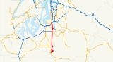
State Route 161, known as Enchanted Parkway within King County
and as Meridian within most of Pierce County
, is a numbered state highway
in the state
of Washington, U.S.A. It extends about 36 miles (57.9 km) from State Route 7 just south of Eatonville
in the south to State Route 18 at Federal Way
in the north.
!County
!Location
!Mile
!Destinations
!Notes
|-
|rowspan=10|Pierce
|
|0.00
|
|
|-
|
|6.10
|Eatonville Cutoff – McKenna, Tacoma, Yelm
|
|-
|rowspan=4|Puyallup
|25.83
|
|Interchange; south end of SR 512 overlap
|-
!colspan=3|South end of freeway
|-
|27.15
|Meridian Street South – Puyallup
|
|-
|28.21
|Pioneer Avenue East – Orting, Puyallup
|
|-
|
|29.15
|
|North end of SR 512 overlap; south end of SR 167 overlap
|-
|rowspan=2|Puyallup
!colspan=3|North end of freeway
|-
|29.87
|
|North end of SR 167 overlap
|-
|Edgewood
|33.23
|Milton Way
|Former SR 514
|-
|King
|Federal Way
|36.17
|
|
|-
King County, Washington
King County is a county located in the U.S. state of Washington. The population in the 2010 census was 1,931,249. King is the most populous county in Washington, and the 14th most populous in the United States....
and as Meridian within most of Pierce County
Pierce County, Washington
right|thumb|[[Tacoma, Washington|Tacoma]] - Seat of Pierce CountyPierce County is the second most populous county in the U.S. state of Washington. Formed out of Thurston County on December 22, 1852, by the legislature of Oregon Territory...
, is a numbered state highway
State highway
State highway, state road or state route can refer to one of three related concepts, two of them related to a state or provincial government in a country that is divided into states or provinces :#A...
in the state
U.S. state
A U.S. state is any one of the 50 federated states of the United States of America that share sovereignty with the federal government. Because of this shared sovereignty, an American is a citizen both of the federal entity and of his or her state of domicile. Four states use the official title of...
of Washington, U.S.A. It extends about 36 miles (57.9 km) from State Route 7 just south of Eatonville
Eatonville, Washington
Eatonville is a town in Pierce County, Washington, United States. The population was 2,758 at the 2010 census.-History:For centuries, Indian people roamed the rivers and streams of the Eatonville area. Indian Henry was one of those who, in 1889, guided the town's founder, Thomas C. Van Eaton, from...
in the south to State Route 18 at Federal Way
Federal Way, Washington
Federal Way is a city in King County, Washington, United States. Federal Way is located between Seattle and Tacoma. Its western boundary is Puget Sound. It is bordered by Des Moines on the north, Kent, unincorporated King County, and Milton on the east and Tacoma and Fife on the south...
in the north.
Major intersections
{| class=wikitable!County
!Location
!Mile
!Destinations
!Notes
|-
|rowspan=10|Pierce
|
|0.00
|
|
|-
|
|6.10
|Eatonville Cutoff – McKenna, Tacoma, Yelm
|
|-
|rowspan=4|Puyallup
|25.83
|
|Interchange; south end of SR 512 overlap
|-
!colspan=3|South end of freeway
|-
|27.15
|Meridian Street South – Puyallup
|
|-
|28.21
|Pioneer Avenue East – Orting, Puyallup
|
|-
|
|29.15
|
|North end of SR 512 overlap; south end of SR 167 overlap
|-
|rowspan=2|Puyallup
!colspan=3|North end of freeway
|-
|29.87
|
|North end of SR 167 overlap
|-
|Edgewood
|33.23
|Milton Way
|Former SR 514
|-
|King
|Federal Way
|36.17
|
|
|-