
.gif)
State Route 1002 (Lehigh County, Pennsylvania)
Encyclopedia
State Route 1002 , locally known as Tilghman Street and Union Boulevard, is a major 13.7 mi (22 km) long east–west road
in the Allentown-Bethlehem-Easton metropolitan area of the U.S. state
of Pennsylvania
. The majority of the roadway is the former alignment of U.S. Route 22, maintained by the Pennsylvania Department of Transportation
as a Quadrant Route, and is not signed except on small white segment markers.
Tilghman Street begins at Pennsylvania Route 100
in Fogelsville, though SR 1002 continues west on Main Street (also old US 22) to the intersection of Church Street (SR 3014). It becomes Union Boulevard just east of the bridge over the Lehigh River
in Allentown; SR 1002 ends at the interchange
with Pennsylvania Route 378
in Bethlehem. Union Boulevard continues over Monocacy Creek
, which forms the border between Lehigh and Northampton Counties, and ends in downtown Bethlehem.
The highway attracts more than the average traffic for roads in the Lehigh Valley
. An average of 21,018 vehicles use it in South Whitehall Township and 21,706 in Allentown each day.
, left Allentown further south, on Hamilton Boulevard (now Pennsylvania Route 222
and U.S. Route 222); the portion near Allentown was Legislative Route 157 (LR 157). Another route west from Allentown (LR 163, later U.S. Route 309) ran northwest from Allentown via Walbert Avenue to Schnecksville. Travelers could continue via New Tripoli
to Lenhartsville, and then along a route approximating the present I-78 to Harrisburg. From Allentown east to downtown Bethlehem, LR 159 used Hanover Avenue and Broad Street. No state highways existed within the city limits of Allentown.
The William Penn Highway
was organized as an alternative to the Lincoln Highway
being parallel to the Pennsylvania Railroad
west of Harrisburg. The route's New York Extension, adopted in 1916, passed through Allentown. The state assigned the Pennsylvania Route 3 designation to this road in 1924, and in 1926 it became part of U.S. Route 22. The road west from Allentown, now College Heights Boulevard, Broadway, Tilghman Street, and Main Street, was designated LR 443 in 1925, and soon the entire shortcut between Allentown and Harrisburg was designated Pennsylvania Route 43. The New York Times
was recommending use of this cutoff by early 1931 and the American Association of State Highway Officials officially moved US 22 to PA 43 on June 8, 1931. The Pennsylvania Department of Highways moved the William Penn Highway name to match. Tilghman Street and Union Boulevard (then Union Street) were once local streets in Allentown and Bethlehem, with no bridge over the Lehigh River
connecting them; Allentown built that bridge in 1929.
 Prior to 1931, there were no state highways in Allentown or a number of other major cities in the state. However, the state did define paths through these cities for the public; in Allentown, US 22 used Hamilton Street, and PA 43 entered on Liberty Street and turned south on 17th Street to reach Hamilton Street. The Pennsylvania General Assembly
passed, on June 22, 1931, a law defining state highways through these cities and changing routes in other cities. LR 443 was defined to use College Heights Boulevard and Tilghman Street to 15th Street, where LR 157 continued along Tilghman Street and Union Boulevard to the Allentown-Bethlehem line. LR 159 was redefined to begin at the same point, continuing on Union Boulevard to Main Street in downtown Bethlehem (and beyond to Easton). The newest part of Tilghman Street includes the bridge over Little Cedar Creek in Trexler Park west of Cedar Crest Boulevard, which dates to 1936, and bypasses the older route via Broadway and College Heights Boulevard. Tilghman Street and Union Boulevard became a major long-distance traffic route, and had eight diners as a reminder of this past importance.
 In addition to US 22, Tilghman Street also carried
U.S. Route 309 and Pennsylvania Route 29
between 19th Street and Seventh Street. They were moved from Hamilton Street with US 22 in 1931, and to a freeway bypass of Allentown in the late 1950s. The Lehigh Valley Thruway
, a freeway taking US 22 around Allentown and Bethlehem to the north, was opened on September 21, 1954. With the opening of these two highways, and the western extension of the Thruway in the late 1950s, no signed Traffic Routes remained on Tilghman Street and Union Boulevard, yet the road was still state maintained. It still carried LR 443, LR 157, and LR 159 through the cities, since the Thruway was assigned a new number — LR 772 — but west of the crossing at Kuhnsville
, LR 443 was moved to the freeway, and the old route became LR Old 443, later LR 443 Parallel.
The road west of Church Street in Fogelsville, which was also a state highway (LR 39084), was removed from the state highway system in the late 1970s. A gap in LR 159 through downtown Bethlehem was created in 1971, at the same time as Washington Avenue and Stefko Boulevard were added to the system as a bypass, with Union Boulevard east of Pennsylvania Route 378
becoming a city street. Thus in 1987, when the new Location Referencing System was adopted, only the portion of Tilghman Street and Union Boulevard between Church Street and PA 378 was assigned a new number: State Route 1002.
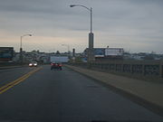
_bridge.jpg) SR 1002 begins at an intersection with Church and Main Streets (State Route 3014) in Fogelsville
SR 1002 begins at an intersection with Church and Main Streets (State Route 3014) in Fogelsville
. It then proceeds east for three-tenths of a mile (0.5 km) as Main Street to an intersection with Pennsylvania Route 100
. Upon crossing SR 100, SR 1002 becomes Tilghman Street. As Tilghman Street approaches the limited-access U.S. Route 22, the road splits into two carriageway
s in preparation for an interchange with US 22, northeast of where US 22 separates from Interstate 78. Past the interchange with US 22, Tilghman Street returns to an undivided roadway and enters the village of Cetronia
.
At an intersection with Werley Road, SR 1002 connects to Interstate 476
(the Northeast Extension of the Pennsylvania Turnpike
) via a ramp leading to the toll plaza for the nearby I-476/US 22 interchange. SR 1002 continues to the southeast, passing over the turnpike. After turning to the northeast, Tilghman Street has a cloverleaf interchange
with Pennsylvania Route 309
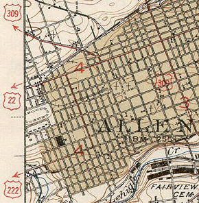
. SR 1002 enters Allentown one quarter mile west of this interchange just before its intersection with 40th Street. Tilghman Street then re-enters South Whitehall for about one block as it crosses Cedar Crest Boulevard, a local north–south arterial, before entering into the city's incorporated limits for a second time.
In Allentown, Tilghman Street (SR 1002) crosses more than 30 major streets in the city. In the more populated part of the city, SR 1002 intersects the 6th and 7th street one-way couplet
forming Pennsylvania Route 145
. East of 4th Street, the road uses the Tilghman Street Bridge to cross Jordan Creek and American Parkway. After intersecting Front Street, SR 1002 crosses the Lehigh River
on the Tilghman Street Viaduct and becomes Union Boulevard. Tilghman Street is still found in east-side Allentown, but it is not connected to SR 1002 in west-side, center city, and upper east-side Allentown.
. After the intersection with Fenwick Street, SR 1002 has a solid west–east routing. East of the Irving Street intersection, SR 1002 intersects Airport Road, the main road to Lehigh Valley International Airport
. Briefly east of Airport Road, Union Boulevard traverses the other streets of east Allentown. SR 1002 enters the city of Bethlehem
from the west as West Union Boulevard.
Approximately 1,500 feet east of the Allentown-Bethlehem boundary, Eaton Avenue is concurrent
with SR 1002 for one-tenth of a mile. The route turns to the south near the junction with Pennsylvania Avenue before taking an increasingly eastern alignment. Third Avenue provides access to and from PA 378
south. SR 1002 terminates at an interchange with Pennsylvania Route 378
. The highway only has access to PA 378 north. The designation continues as W. Union Boulevard upon entering the eastern sections of Bethlehem in Northampton County
.
Road
A road is a thoroughfare, route, or way on land between two places, which typically has been paved or otherwise improved to allow travel by some conveyance, including a horse, cart, or motor vehicle. Roads consist of one, or sometimes two, roadways each with one or more lanes and also any...
in the Allentown-Bethlehem-Easton metropolitan area of the U.S. state
U.S. state
A U.S. state is any one of the 50 federated states of the United States of America that share sovereignty with the federal government. Because of this shared sovereignty, an American is a citizen both of the federal entity and of his or her state of domicile. Four states use the official title of...
of Pennsylvania
Pennsylvania
The Commonwealth of Pennsylvania is a U.S. state that is located in the Northeastern and Mid-Atlantic regions of the United States. The state borders Delaware and Maryland to the south, West Virginia to the southwest, Ohio to the west, New York and Ontario, Canada, to the north, and New Jersey to...
. The majority of the roadway is the former alignment of U.S. Route 22, maintained by the Pennsylvania Department of Transportation
Pennsylvania Department of Transportation
The Pennsylvania Department of Transportation oversees transportation issues in the Commonwealth of Pennsylvania. The administrator of PennDOT is the Pennsylvania Secretary of Transportation, currently Barry Schoch Presently, PennDOT supports over of state roads and highways, about 25,000...
as a Quadrant Route, and is not signed except on small white segment markers.
Tilghman Street begins at Pennsylvania Route 100
Pennsylvania Route 100
Pennsylvania Route 100 is a state highway in the U.S. state of Pennsylvania that runs from U.S. Route 202 in West Chester, Pennsylvania to Pennsylvania Route 309 in Pleasant Corners, Pennsylvania....
in Fogelsville, though SR 1002 continues west on Main Street (also old US 22) to the intersection of Church Street (SR 3014). It becomes Union Boulevard just east of the bridge over the Lehigh River
Lehigh River
The Lehigh River, a tributary of the Delaware River, is a river located in eastern Pennsylvania, in the United States. Part of the Lehigh, along with a number of its tributaries, is designated a Pennsylvania Scenic River by the state's Department of Conservation and Natural Resources...
in Allentown; SR 1002 ends at the interchange
Interchange (road)
In the field of road transport, an interchange is a road junction that typically uses grade separation, and one or more ramps, to permit traffic on at least one highway to pass through the junction without directly crossing any other traffic stream. It differs from a standard intersection, at which...
with Pennsylvania Route 378
Pennsylvania Route 378
Pennsylvania Route 378 is a north-to-south road in Lehigh and Northampton counties. Its northern terminus is at U.S. Route 22 in Bethlehem and the portion north of the Lehigh River is a freeway. The highway was once Interstate 378 but when Interstate 78 was rerouted from U.S...
in Bethlehem. Union Boulevard continues over Monocacy Creek
Monocacy Creek
Monocacy Creek is a tributary of the Lehigh River in Northampton County, Pennsylvania in the United States.One of only 56 limestone streams in the state of Pennsylvania, the creek's headwaters lie in the slate belt, near the borough of Chapman....
, which forms the border between Lehigh and Northampton Counties, and ends in downtown Bethlehem.
The highway attracts more than the average traffic for roads in the Lehigh Valley
Lehigh Valley
The Lehigh Valley, known officially by the United States Census Bureau as the Allentown-Bethlehem-Easton, PA-NJ metropolitan area and referred to locally as The Valley and A-B-E, is a metropolitan region consisting of Lehigh, Northampton, Berks, and Carbon counties in eastern Pennsylvania and...
. An average of 21,018 vehicles use it in South Whitehall Township and 21,706 in Allentown each day.
History
When the state began taking over state highways through the Sproul Road Bill, signed May 31, 1911, this system did not include the direct Allentown-Harrisburg route that Interstate 78 and the parallel Tilghman Street now form part of. The main route to Harrisburg, which would soon become the William Penn HighwayWilliam Penn Highway
The William Penn Highway was an auto trail in the United States, generally running from Pittsburgh east to New York City. It served as the eastern end of the Pikes Peak Ocean-to-Ocean Highway. The William Penn Highway Association of Pennsylvania was organized March 27, 1916 to promote a road...
, left Allentown further south, on Hamilton Boulevard (now Pennsylvania Route 222
Pennsylvania Route 222
Pennsylvania Route 222 is a -long state highway contained entirely in Allentown, Lehigh County, Pennsylvania and its immediate suburbs mostly along Hamilton Boulevard. The route, in center city Allentown, is aligned along West Hamilton, West Linden, and West Walnut Streets...
and U.S. Route 222); the portion near Allentown was Legislative Route 157 (LR 157). Another route west from Allentown (LR 163, later U.S. Route 309) ran northwest from Allentown via Walbert Avenue to Schnecksville. Travelers could continue via New Tripoli
New Tripoli, Pennsylvania
New Tripoli is a small rural village in Lynn Township, in Lehigh County, Pennsylvania, in the United States.The village is located at the intersection of Madison Street and Pennsylvania Route 143 near Pennsylvania Route 309 in the Lehigh Valley region of Pennsylvania...
to Lenhartsville, and then along a route approximating the present I-78 to Harrisburg. From Allentown east to downtown Bethlehem, LR 159 used Hanover Avenue and Broad Street. No state highways existed within the city limits of Allentown.
The William Penn Highway
William Penn Highway
The William Penn Highway was an auto trail in the United States, generally running from Pittsburgh east to New York City. It served as the eastern end of the Pikes Peak Ocean-to-Ocean Highway. The William Penn Highway Association of Pennsylvania was organized March 27, 1916 to promote a road...
was organized as an alternative to the Lincoln Highway
Lincoln Highway
The Lincoln Highway was the first road across the United States of America.Conceived and promoted by entrepreneur Carl G. Fisher, the Lincoln Highway spanned coast-to-coast from Times Square in New York City to Lincoln Park in San Francisco, originally through 13 states: New York, New Jersey,...
being parallel to the Pennsylvania Railroad
Pennsylvania Railroad
The Pennsylvania Railroad was an American Class I railroad, founded in 1846. Commonly referred to as the "Pennsy", the PRR was headquartered in Philadelphia, Pennsylvania....
west of Harrisburg. The route's New York Extension, adopted in 1916, passed through Allentown. The state assigned the Pennsylvania Route 3 designation to this road in 1924, and in 1926 it became part of U.S. Route 22. The road west from Allentown, now College Heights Boulevard, Broadway, Tilghman Street, and Main Street, was designated LR 443 in 1925, and soon the entire shortcut between Allentown and Harrisburg was designated Pennsylvania Route 43. The New York Times
The New York Times
The New York Times is an American daily newspaper founded and continuously published in New York City since 1851. The New York Times has won 106 Pulitzer Prizes, the most of any news organization...
was recommending use of this cutoff by early 1931 and the American Association of State Highway Officials officially moved US 22 to PA 43 on June 8, 1931. The Pennsylvania Department of Highways moved the William Penn Highway name to match. Tilghman Street and Union Boulevard (then Union Street) were once local streets in Allentown and Bethlehem, with no bridge over the Lehigh River
Lehigh River
The Lehigh River, a tributary of the Delaware River, is a river located in eastern Pennsylvania, in the United States. Part of the Lehigh, along with a number of its tributaries, is designated a Pennsylvania Scenic River by the state's Department of Conservation and Natural Resources...
connecting them; Allentown built that bridge in 1929.
Pennsylvania General Assembly
The Pennsylvania General Assembly is the state legislature of the U.S. state of Pennsylvania. The legislature convenes in the State Capitol building in Harrisburg. In colonial times , the legislature was known as the Pennsylvania Provincial Assembly. Since the Constitution of 1776, written by...
passed, on June 22, 1931, a law defining state highways through these cities and changing routes in other cities. LR 443 was defined to use College Heights Boulevard and Tilghman Street to 15th Street, where LR 157 continued along Tilghman Street and Union Boulevard to the Allentown-Bethlehem line. LR 159 was redefined to begin at the same point, continuing on Union Boulevard to Main Street in downtown Bethlehem (and beyond to Easton). The newest part of Tilghman Street includes the bridge over Little Cedar Creek in Trexler Park west of Cedar Crest Boulevard, which dates to 1936, and bypasses the older route via Broadway and College Heights Boulevard. Tilghman Street and Union Boulevard became a major long-distance traffic route, and had eight diners as a reminder of this past importance.
Concurrency (road)
A concurrency, overlap, or coincidence in a road network is an instance of one physical road bearing two or more different highway, motorway, or other route numbers...
U.S. Route 309 and Pennsylvania Route 29
Pennsylvania Route 29
Pennsylvania Route 29 is a 118 mile long north–south state highway that runs through most of eastern Pennsylvania. The route currently exists in two segments, a southern segment and a northern segment. The southernmost terminus of the designation is at U.S. Route 30 in Malvern...
between 19th Street and Seventh Street. They were moved from Hamilton Street with US 22 in 1931, and to a freeway bypass of Allentown in the late 1950s. The Lehigh Valley Thruway
Lehigh Valley Thruway
U.S. Route 22 is an east–west route stretching from Cincinnati, Ohio in the west to Newark, New Jersey in the east. In Pennsylvania, the route runs for between the West Virginia state line at Washington County, where it is a limited-access expressway-grade route through the western suburbs...
, a freeway taking US 22 around Allentown and Bethlehem to the north, was opened on September 21, 1954. With the opening of these two highways, and the western extension of the Thruway in the late 1950s, no signed Traffic Routes remained on Tilghman Street and Union Boulevard, yet the road was still state maintained. It still carried LR 443, LR 157, and LR 159 through the cities, since the Thruway was assigned a new number — LR 772 — but west of the crossing at Kuhnsville
Kuhnsville, Pennsylvania
Kuhnsville is a small unincorporated village in Upper Macungie Township, Lehigh County, Pennsylvania. Along with the adjacent villages of Chapmans and Ruppsville , Kuhnsville forms the eastern edge of the transportation and warehousing business district centered on Fogelsville. It uses the...
, LR 443 was moved to the freeway, and the old route became LR Old 443, later LR 443 Parallel.
The road west of Church Street in Fogelsville, which was also a state highway (LR 39084), was removed from the state highway system in the late 1970s. A gap in LR 159 through downtown Bethlehem was created in 1971, at the same time as Washington Avenue and Stefko Boulevard were added to the system as a bypass, with Union Boulevard east of Pennsylvania Route 378
Pennsylvania Route 378
Pennsylvania Route 378 is a north-to-south road in Lehigh and Northampton counties. Its northern terminus is at U.S. Route 22 in Bethlehem and the portion north of the Lehigh River is a freeway. The highway was once Interstate 378 but when Interstate 78 was rerouted from U.S...
becoming a city street. Thus in 1987, when the new Location Referencing System was adopted, only the portion of Tilghman Street and Union Boulevard between Church Street and PA 378 was assigned a new number: State Route 1002.
Tilghman Street
Fogelsville, Pennsylvania
Fogelsville is a village in Lehigh County, Pennsylvania, in the United States. It is a suburb of Allentown, in Upper Macungie Township, in the Lehigh Valley region of the state....
. It then proceeds east for three-tenths of a mile (0.5 km) as Main Street to an intersection with Pennsylvania Route 100
Pennsylvania Route 100
Pennsylvania Route 100 is a state highway in the U.S. state of Pennsylvania that runs from U.S. Route 202 in West Chester, Pennsylvania to Pennsylvania Route 309 in Pleasant Corners, Pennsylvania....
. Upon crossing SR 100, SR 1002 becomes Tilghman Street. As Tilghman Street approaches the limited-access U.S. Route 22, the road splits into two carriageway
Carriageway
A carriageway consists of a width of road on which a vehicle is not restricted by any physical barriers or separation to move laterally...
s in preparation for an interchange with US 22, northeast of where US 22 separates from Interstate 78. Past the interchange with US 22, Tilghman Street returns to an undivided roadway and enters the village of Cetronia
Cetronia, Pennsylvania
Cetronia is an unincorporated community in South Whitehall Township, Lehigh County, Pennsylvania, United States, near the city of Allentown. State Route 1002 , Pennsylvania Route 309, and Cedar Crest Boulevard run through Cetronia....
.
At an intersection with Werley Road, SR 1002 connects to Interstate 476
Interstate 476
Interstate 476 is a auxiliary Interstate Highway in the U.S. state of Pennsylvania designated between Interstate 95 near Chester and Interstate 81 near Scranton, serving as the primary north–south Interstate corridor through eastern Pennsylvania....
(the Northeast Extension of the Pennsylvania Turnpike
Pennsylvania Turnpike
The Pennsylvania Turnpike is a toll highway system operated by the Pennsylvania Turnpike Commission in the Commonwealth of Pennsylvania, United States. The three sections of the turnpike system total . The main section extends from Ohio to New Jersey and is long...
) via a ramp leading to the toll plaza for the nearby I-476/US 22 interchange. SR 1002 continues to the southeast, passing over the turnpike. After turning to the northeast, Tilghman Street has a cloverleaf interchange
Cloverleaf interchange
A cloverleaf interchange is a two-level interchange in which left turns, reverse direction in left-driving regions, are handled by ramp roads...
with Pennsylvania Route 309
Pennsylvania Route 309
Pennsylvania Route 309 is a major highway which runs for 134 miles through Pennsylvania in the United States. It connects Philadelphia and its northern suburbs to Allentown, Hazleton, and Wilkes-Barre. A limited-access highway portion of PA 309 in the Wilkes-Barre area is known as the North...
. SR 1002 enters Allentown one quarter mile west of this interchange just before its intersection with 40th Street. Tilghman Street then re-enters South Whitehall for about one block as it crosses Cedar Crest Boulevard, a local north–south arterial, before entering into the city's incorporated limits for a second time.
In Allentown, Tilghman Street (SR 1002) crosses more than 30 major streets in the city. In the more populated part of the city, SR 1002 intersects the 6th and 7th street one-way couplet
One-way traffic
One-way traffic is traffic that moves in a single direction. A one-way street is a street either facilitating only one-way traffic, or designed to direct vehicles to move in one direction.-General signs:...
forming Pennsylvania Route 145
Pennsylvania Route 145
Pennsylvania Route 145 , unofficially known as "the gateway to Allentown", is a long north–south state highway in the Lehigh Valley area of eastern Pennsylvania...
. East of 4th Street, the road uses the Tilghman Street Bridge to cross Jordan Creek and American Parkway. After intersecting Front Street, SR 1002 crosses the Lehigh River
Lehigh River
The Lehigh River, a tributary of the Delaware River, is a river located in eastern Pennsylvania, in the United States. Part of the Lehigh, along with a number of its tributaries, is designated a Pennsylvania Scenic River by the state's Department of Conservation and Natural Resources...
on the Tilghman Street Viaduct and becomes Union Boulevard. Tilghman Street is still found in east-side Allentown, but it is not connected to SR 1002 in west-side, center city, and upper east-side Allentown.
Union Boulevard
East of the Tilghman Street Viaduct, SR 1002 traverses numerous streets in the eastern section of AllentownAllentown, Pennsylvania
Allentown is a city located in Lehigh County, Pennsylvania, in the United States. It is Pennsylvania's third most populous city, after Philadelphia and Pittsburgh, and the 215th largest city in the United States. As of the 2010 census, the city had a total population of 118,032 and is currently...
. After the intersection with Fenwick Street, SR 1002 has a solid west–east routing. East of the Irving Street intersection, SR 1002 intersects Airport Road, the main road to Lehigh Valley International Airport
Lehigh Valley International Airport
Lehigh Valley International Airport , formerly Allentown-Bethlehem-Easton International Airport, is a public airport in Hanover Township, Lehigh County, Pennsylvania....
. Briefly east of Airport Road, Union Boulevard traverses the other streets of east Allentown. SR 1002 enters the city of Bethlehem
Bethlehem, Pennsylvania
Bethlehem is a city in Lehigh and Northampton Counties in the Lehigh Valley region of eastern Pennsylvania, in the United States. As of the 2010 census, the city had a total population of 74,982, making it the seventh largest city in Pennsylvania, after Philadelphia, Pittsburgh, Allentown, Erie,...
from the west as West Union Boulevard.
Approximately 1,500 feet east of the Allentown-Bethlehem boundary, Eaton Avenue is concurrent
Concurrency (road)
A concurrency, overlap, or coincidence in a road network is an instance of one physical road bearing two or more different highway, motorway, or other route numbers...
with SR 1002 for one-tenth of a mile. The route turns to the south near the junction with Pennsylvania Avenue before taking an increasingly eastern alignment. Third Avenue provides access to and from PA 378
Pennsylvania Route 378
Pennsylvania Route 378 is a north-to-south road in Lehigh and Northampton counties. Its northern terminus is at U.S. Route 22 in Bethlehem and the portion north of the Lehigh River is a freeway. The highway was once Interstate 378 but when Interstate 78 was rerouted from U.S...
south. SR 1002 terminates at an interchange with Pennsylvania Route 378
Pennsylvania Route 378
Pennsylvania Route 378 is a north-to-south road in Lehigh and Northampton counties. Its northern terminus is at U.S. Route 22 in Bethlehem and the portion north of the Lehigh River is a freeway. The highway was once Interstate 378 but when Interstate 78 was rerouted from U.S...
. The highway only has access to PA 378 north. The designation continues as W. Union Boulevard upon entering the eastern sections of Bethlehem in Northampton County
Northampton County, Pennsylvania
As of the 2010 census, the county was 86.3% White, 5.0% Black or African American, 0.2% Native American or Alaskan Native, 2.4% Asian, 0.0% Native Hawaiian, 2.2% were two or more races, and 3.8% were some other race. 10.5% of the population were of Hispanic or Latino ancestry.As of the census of...
.