
Pennsylvania Route 145
Encyclopedia
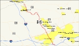
Pennsylvania Route 145 unofficially known as "the gateway to Allentown", is a 20.46 mi (32.93 km) long north–south state highway in the Lehigh Valley
area of eastern Pennsylvania
. It connects Interstate 78
and Pennsylvania Route 309
in Lanark
to Pennsylvania Route 248
in Weiders Crossing
.
Route 145 is the main arterial into Allentown, Pennsylvania
, the third-largest city in the state. In Whitehall Township
, a seven-mile (11.2 km) portion of PA 145 is known as MacArthur Road, named in honor of Gen. Douglas MacArthur
.. MacArthur Road is almost entirely divided
; between US 22
and Eberhart Road, it is six-lanes wide with ramps. In Whitehall Township, MacArthur Road is the location of the main commercial center of the Lehigh Valley
. The Lehigh Valley Mall
, a large Allentown-area shopping mall, is situated on Route 145.
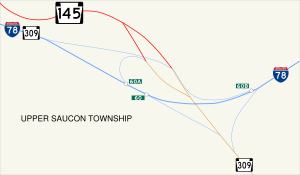
in Upper Saucon Township
, located 4 miles (6.4 km) southeast of downtown Allentown
. This interchange is not only the southern terminus of PA 145, but also the eastern terminus of the Interstate 78/PA Route 309 concurrency
. Just north of I-78, PA 145 is known as South Pike Ave. and meets Vera Cruz Rd. and Oakhurst Dr. at an at-grade intersection
.
 The route continues to the north as it runs up a hill on South Mountain
with S-curves. Upon entering the village of Summit Lawn
at the peak of South Mountain, PA 145 intersects Rock Rd., providing access to westbound I-78 and northbound PA 309. PA 145 then begins to go down another hill on South Mountain.
, Allentown, and Emmaus
. Past Emaus Avenue, PA 145 continues through the Allentown neighborhood of Mountainville, passing east of a shopping center with stores such as Price Rite and K-Mart. Exiting Mountainville, PA 145 turns west onto Susquehanna Street and crosses both Trout Creek and the Norfolk Southern Railway
before making a wide curve to the north and becoming S. 5th St.
Just after becoming S. 5th St., PA 145 divides into a pair of one-way
streets, known as a one-way couplet. Southbound PA 145 follows S. 6th St., which then turns to the east onto Wyoming St. and reunites with the other half at South Fifth Street. Northbound PA 145 is known as S. 5th St.; it passes Good Shepherd
Hospital, turns west onto Auburn St., and reunites with southbound PA 145 at a junction with S. 6th St. and Lehigh St
. North of the split, PA 145 becomes Lehigh St., crosses Little Lehigh Creek
, and intersects Martin Luther King, Jr.
Drive. Slightly north of the M.L.K. Drive intersection, PA 145 progresses on its alignment up a long hill.
At the top of the hill, PA 145 divides again, as northbound PA 145 turns east onto Union St. while southbound PA 145 comes from the west, also as Union St. Just after becoming Union St., northbound PA 145 turns back northward to become 6th St. While southbound PA 145 is known as 7th St., it passes through the commercial district of Allentown and is a major one-way three-lane street home to one of Allentown's oldest supermarkets, Little Apple Market. At the intersection of 7th and Hamilton Streets, there is a monument called the Sailors and Soldiers Monument in Center City, Allentown. The monument was built to honor General Phillip Sheridan’s Civil War
unit and the 47th Regiment of Pennsylvania Volunteers. Meanwhile, Route 145 continues its alignment as 6th St. and intersects the northern terminus of Route 222
(which is split into Walnut and Linden Streets).
 Sixth St. is home to The Morning Call
, Allentown's main newspaper distributor. In the northern region of Allentown, PA 145 (as Seventh and Sixth Streets) intersects Tilghman St., one of the major streets in Allentown. After crossing Tilghman St., northbound PA 145 turns west onto Washington St. and then north onto 7th St. to reunite with southbound Route 145. North of Washington St., PA 145 continues its course as 7th St., consisting of three lanes. Then, PA 145 crosses a tall bridge over Sumner Avenue, leaves Allentown, and becomes MacArthur Rd.
 After crossing the bridge, PA 145 enters Whitehall Township
and becomes a divided highway
known as MacArthur Road, consisting of four lanes. This section of PA 145, previously known as Seventh Street Pike, or the Seventh Street Extension, was renamed in honor of Gen. Douglas MacArthur
by township supervisors in 1942. In Whitehall, PA 145 passes several intersections, including Mickley Rd., Jordan Pkwy., and, after crossing Jordan Creek, Fairmont Ave. Just north of Fairmont Ave., PA 145 intersects the Lehigh Valley Thruway
(US 22) at a full cloverleaf interchange
. North of this point, PA 145 has been widened to six lanes.
Just north of US 22, PA 145 traverses the main commercial center of the Lehigh Valley
, passing to the west of Lehigh Valley Mall
. The first junction is Grape St., with two ramps to access it from both directions. PA 145 continues through numerous stores and businesses, passing to the west of Whitehall Mall
and making a second junction with Mickley Rd. before crossing Schadt Ave. At the intersection with Eberhart Rd., PA 145 is no longer a divided, six-lane road, but rather an undivided four-lane road. About a mile north of Eberhart Rd., PA 145 becomes a divided highway
again, but with only four lanes.
About a mile west of Northampton
, PA 145 meets PA Route 329
. North of there, PA 145 continues its course as MacArthur Rd. MacArthur Rd. comes to an end as PA 145 continues its alignment as a two lane road; at this point, the Lehigh River
is almost visible and is only about 280 feet (85.3 meters) east of PA 145. After crossing the village of Laurys Station
, PA 145 curves to the west and leaves Lehigh County
while crossing the Lehigh River
on the Treichlers Bridge.
and intersects Blue Mountain Drive, which has direct access to the Blue Mountain Ski Area
. Then, PA 145 curves to the south as Riverview Drive, later diverging to the west and back to the north, parallel to the Lehigh River. PA 145 enters Walnutport
from the south as Riverview Drive which becomes Best Avenue upon entering the borough. At the center of Walnutport, Route 145 meets Main Street. In Lehigh Township
, PA 145 becomes Riverview Drive once again as it terminates at an intersection with PA Route 248
located in Weiders Crossing
. The northern terminus of PA Route 873
is also on PA 248, just north of PA 145.
to Bath, with both termini at Pennsylvania Route 45. At the time, from Whitehall Township hamlet of Cementon to Bath
, PA 145 was routed on what is today Pennsylvania Route 329
. From Cementon to Tilghman Street in Allentown, PA 329 was signed as the modern MacArthur Road section of PA 145.
By 1940, Route 145 was a north–south route, replacing the previous PA 329 designation. From Tilghman Street to Lehigh Street
, US 309 and PA 29 were designated along 7th Street and the northernmost part of Lehigh Street, sections of the modern PA 145. Prior to the 1960s, US 309 was designated onto the southernmost segment of present-day PA 145, from downtown Allentown to Summit Lawn
.
By 1960, the southern terminus of PA 145 was slightly moved north to an interchange with I-78 and U.S. Route 22
in Whitehall Township.
In 1984, PennDOT proposed to extend Route 145 to Interstate 78
and Pennsylvania Route 309
in Lanark
. Traffic engineer Samuel D. Darrohh said that Allentown is one of few Pennsylvania cities without a traffic route going through it. He supported his idea by saying that motorists also might be aided if U.S. Route 222 eventually is extended along Hamilton Boulevard to connect with the proposed PA 145 corridor. By 1991, the extension was completed.
Lehigh Valley
The Lehigh Valley, known officially by the United States Census Bureau as the Allentown-Bethlehem-Easton, PA-NJ metropolitan area and referred to locally as The Valley and A-B-E, is a metropolitan region consisting of Lehigh, Northampton, Berks, and Carbon counties in eastern Pennsylvania and...
area of eastern Pennsylvania
Pennsylvania
The Commonwealth of Pennsylvania is a U.S. state that is located in the Northeastern and Mid-Atlantic regions of the United States. The state borders Delaware and Maryland to the south, West Virginia to the southwest, Ohio to the west, New York and Ontario, Canada, to the north, and New Jersey to...
. It connects Interstate 78
Interstate 78
Interstate 78 is an Interstate Highway in the Northeast United States, running 144 miles from Interstate 81 northeast of Harrisburg, Pennsylvania, through Allentown, Pennsylvania, and western and northern New Jersey to the Holland Tunnel and Lower Manhattan in New York City.I-78 is a major road...
and Pennsylvania Route 309
Pennsylvania Route 309
Pennsylvania Route 309 is a major highway which runs for 134 miles through Pennsylvania in the United States. It connects Philadelphia and its northern suburbs to Allentown, Hazleton, and Wilkes-Barre. A limited-access highway portion of PA 309 in the Wilkes-Barre area is known as the North...
in Lanark
Lanark, Pennsylvania
Lanark is a small unincorporated village located in Upper Saucon Township, Lehigh County, Pennsylvania. Residents of Lanark are served by the Center Valley and Coopersburg Post Offices with zip code of 18034 and 18036, respectively. Lanark is located within Southern Lehigh School District...
to Pennsylvania Route 248
Pennsylvania Route 248
Pennsylvania Route 248 is a long state highway in eastern portions of the U.S. state of Pennsylvania. The western terminus of the route is at U.S. Route 209 in Weissport. The eastern terminus is at Pennsylvania Route 611 in Easton....
in Weiders Crossing
Lehigh Gap, Pennsylvania
The Lehigh Gap, located in Lower Towamensing Township, Carbon County, Pennsylvania, is a water gap formed by the Lehigh River where it cuts through Blue Mountain in the state of Pennsylvania in the United States. The gap allows easy travel between Carbon County to the north and Lehigh and...
.
Route 145 is the main arterial into Allentown, Pennsylvania
Allentown, Pennsylvania
Allentown is a city located in Lehigh County, Pennsylvania, in the United States. It is Pennsylvania's third most populous city, after Philadelphia and Pittsburgh, and the 215th largest city in the United States. As of the 2010 census, the city had a total population of 118,032 and is currently...
, the third-largest city in the state. In Whitehall Township
Whitehall Township, Pennsylvania
Whitehall Township is a township in Lehigh County, Pennsylvania, in the United States. It is a suburb of Allentown, Pennsylvania, in the Lehigh Valley region of the state.The population of Whitehall Township was 24,896 at the 2000 census.-Geography:...
, a seven-mile (11.2 km) portion of PA 145 is known as MacArthur Road, named in honor of Gen. Douglas MacArthur
Douglas MacArthur
General of the Army Douglas MacArthur was an American general and field marshal of the Philippine Army. He was a Chief of Staff of the United States Army during the 1930s and played a prominent role in the Pacific theater during World War II. He received the Medal of Honor for his service in the...
.. MacArthur Road is almost entirely divided
Divided Highway
Divided Highway is a compilation album by American rock band The Doobie Brothers, released in 2003. . All tracks are taken from the albums Cycles and Brotherhood .-Track listing:...
; between US 22
U.S. Route 22
U.S. Route 22 is a west–east route and is one of the original United States highways of 1926, running from Cincinnati, Ohio, at US 27, US 42, US 127, and US 52 to Newark, New Jersey, at U.S. Route 1/9 near the Newark Liberty International Airport.US 22 also carries the names of the William...
and Eberhart Road, it is six-lanes wide with ramps. In Whitehall Township, MacArthur Road is the location of the main commercial center of the Lehigh Valley
Lehigh Valley
The Lehigh Valley, known officially by the United States Census Bureau as the Allentown-Bethlehem-Easton, PA-NJ metropolitan area and referred to locally as The Valley and A-B-E, is a metropolitan region consisting of Lehigh, Northampton, Berks, and Carbon counties in eastern Pennsylvania and...
. The Lehigh Valley Mall
Lehigh Valley Mall
The Lehigh Valley Mall is an enclosed super-regional shopping mall located in Whitehall Township, Lehigh County, Pennsylvania in the United States. It is the largest shopping mall in the Lehigh Valley region of Pennsylvania....
, a large Allentown-area shopping mall, is situated on Route 145.
South Mountain
PA 145 begins at an interchange with Interstate 78 at exit 60 and PA Route 309Pennsylvania Route 309
Pennsylvania Route 309 is a major highway which runs for 134 miles through Pennsylvania in the United States. It connects Philadelphia and its northern suburbs to Allentown, Hazleton, and Wilkes-Barre. A limited-access highway portion of PA 309 in the Wilkes-Barre area is known as the North...
in Upper Saucon Township
Upper Saucon Township, Pennsylvania
Upper Saucon Township is a township in Lehigh County, Pennsylvania, in the United States. It is a suburb of Allentown, Pennsylvania, in the Lehigh Valley region of the state, and geographically in the Saucon Valley....
, located 4 miles (6.4 km) southeast of downtown Allentown
Allentown, Pennsylvania
Allentown is a city located in Lehigh County, Pennsylvania, in the United States. It is Pennsylvania's third most populous city, after Philadelphia and Pittsburgh, and the 215th largest city in the United States. As of the 2010 census, the city had a total population of 118,032 and is currently...
. This interchange is not only the southern terminus of PA 145, but also the eastern terminus of the Interstate 78/PA Route 309 concurrency
Concurrency (road)
A concurrency, overlap, or coincidence in a road network is an instance of one physical road bearing two or more different highway, motorway, or other route numbers...
. Just north of I-78, PA 145 is known as South Pike Ave. and meets Vera Cruz Rd. and Oakhurst Dr. at an at-grade intersection
At-grade intersection
An at-grade intersection is a junction at which two or more transport axes cross at the same level .-Traffic management:With areas of high or fast traffic, an at-grade intersection normally requires a traffic control device such as a stop sign, traffic light or railway signal to manage conflicting...
.
South Mountain (eastern Pennsylvania)
South Mountain is a colloquial name applied to features in the mountain range extending south and south west from the Lehigh Valley to the Lebanon Valley regions of Pennsylvania. At times, it also been known as Durham Hills, Reading Hills, and the Lehigh Mountains...
with S-curves. Upon entering the village of Summit Lawn
Summit Lawn, Pennsylvania
Summit Lawn is a small unincorporated village in Lehigh County, Pennsylvania, in the Lehigh Valley region of the state. Parts of Summit Lawn are in Upper Saucon Township while others are in Salisbury Township. The Salisbury Township government offices are located in Summit Lawn.Pennsylvania Route...
at the peak of South Mountain, PA 145 intersects Rock Rd., providing access to westbound I-78 and northbound PA 309. PA 145 then begins to go down another hill on South Mountain.
Allentown
Going down a steep hill, PA 145 enters the city of Allentown as South 4th St. At the end of the hill, PA 145 intersects Emaus Avenue, a major road that connects BethlehemBethlehem, Pennsylvania
Bethlehem is a city in Lehigh and Northampton Counties in the Lehigh Valley region of eastern Pennsylvania, in the United States. As of the 2010 census, the city had a total population of 74,982, making it the seventh largest city in Pennsylvania, after Philadelphia, Pittsburgh, Allentown, Erie,...
, Allentown, and Emmaus
Emmaus, Pennsylvania
Emmaus is a borough in Lehigh County, Pennsylvania, in the United States. It is located five miles southwest of Allentown, Pennsylvania, in the Lehigh Valley region of the state.The population of Emmaus was 11,313 at the 2000 census...
. Past Emaus Avenue, PA 145 continues through the Allentown neighborhood of Mountainville, passing east of a shopping center with stores such as Price Rite and K-Mart. Exiting Mountainville, PA 145 turns west onto Susquehanna Street and crosses both Trout Creek and the Norfolk Southern Railway
Norfolk Southern Railway
The Norfolk Southern Railway is a Class I railroad in the United States, owned by the Norfolk Southern Corporation. With headquarters in Norfolk, Virginia, the company operates 21,500 route miles in 22 eastern states, the District of Columbia and the province of Ontario, Canada...
before making a wide curve to the north and becoming S. 5th St.
Just after becoming S. 5th St., PA 145 divides into a pair of one-way
One-way traffic
One-way traffic is traffic that moves in a single direction. A one-way street is a street either facilitating only one-way traffic, or designed to direct vehicles to move in one direction.-General signs:...
streets, known as a one-way couplet. Southbound PA 145 follows S. 6th St., which then turns to the east onto Wyoming St. and reunites with the other half at South Fifth Street. Northbound PA 145 is known as S. 5th St.; it passes Good Shepherd
Good Shepherd
Good Shepherd may refer to:In Christianity:* The Good Shepherd , pericope found in John 10:1-21, and a popular image in which the Good Shepherd represents Jesus...
Hospital, turns west onto Auburn St., and reunites with southbound PA 145 at a junction with S. 6th St. and Lehigh St
Lehigh Street
Lehigh Street is a major road that connects Emmaus, Pennsylvania in the west to Allentown, Pennsylvania in the east, in the Lehigh Valley region of Pennsylvania, in the United States...
. North of the split, PA 145 becomes Lehigh St., crosses Little Lehigh Creek
Little Lehigh Creek
The Little Lehigh Creek is approximately long, in eastern Pennsylvania, in the United States. It is also sometimes referred to as the Little Lehigh River. It is called the Little Lehigh because it is the largest tributary of the Lehigh River....
, and intersects Martin Luther King, Jr.
Martin Luther King, Jr.
Martin Luther King, Jr. was an American clergyman, activist, and prominent leader in the African-American Civil Rights Movement. He is best known for being an iconic figure in the advancement of civil rights in the United States and around the world, using nonviolent methods following the...
Drive. Slightly north of the M.L.K. Drive intersection, PA 145 progresses on its alignment up a long hill.
At the top of the hill, PA 145 divides again, as northbound PA 145 turns east onto Union St. while southbound PA 145 comes from the west, also as Union St. Just after becoming Union St., northbound PA 145 turns back northward to become 6th St. While southbound PA 145 is known as 7th St., it passes through the commercial district of Allentown and is a major one-way three-lane street home to one of Allentown's oldest supermarkets, Little Apple Market. At the intersection of 7th and Hamilton Streets, there is a monument called the Sailors and Soldiers Monument in Center City, Allentown. The monument was built to honor General Phillip Sheridan’s Civil War
American Civil War
The American Civil War was a civil war fought in the United States of America. In response to the election of Abraham Lincoln as President of the United States, 11 southern slave states declared their secession from the United States and formed the Confederate States of America ; the other 25...
unit and the 47th Regiment of Pennsylvania Volunteers. Meanwhile, Route 145 continues its alignment as 6th St. and intersects the northern terminus of Route 222
Pennsylvania Route 222
Pennsylvania Route 222 is a -long state highway contained entirely in Allentown, Lehigh County, Pennsylvania and its immediate suburbs mostly along Hamilton Boulevard. The route, in center city Allentown, is aligned along West Hamilton, West Linden, and West Walnut Streets...
(which is split into Walnut and Linden Streets).
The Morning Call
The Morning Call is a daily newspaper based in Allentown, Pennsylvania, in the United States. The newspaper is owned by the Tribune Company, whose other publications include the Chicago Tribune, Los Angeles Times and Baltimore Sun....
, Allentown's main newspaper distributor. In the northern region of Allentown, PA 145 (as Seventh and Sixth Streets) intersects Tilghman St., one of the major streets in Allentown. After crossing Tilghman St., northbound PA 145 turns west onto Washington St. and then north onto 7th St. to reunite with southbound Route 145. North of Washington St., PA 145 continues its course as 7th St., consisting of three lanes. Then, PA 145 crosses a tall bridge over Sumner Avenue, leaves Allentown, and becomes MacArthur Rd.
MacArthur Road
Whitehall Township, Pennsylvania
Whitehall Township is a township in Lehigh County, Pennsylvania, in the United States. It is a suburb of Allentown, Pennsylvania, in the Lehigh Valley region of the state.The population of Whitehall Township was 24,896 at the 2000 census.-Geography:...
and becomes a divided highway
Divided Highway
Divided Highway is a compilation album by American rock band The Doobie Brothers, released in 2003. . All tracks are taken from the albums Cycles and Brotherhood .-Track listing:...
known as MacArthur Road, consisting of four lanes. This section of PA 145, previously known as Seventh Street Pike, or the Seventh Street Extension, was renamed in honor of Gen. Douglas MacArthur
Douglas MacArthur
General of the Army Douglas MacArthur was an American general and field marshal of the Philippine Army. He was a Chief of Staff of the United States Army during the 1930s and played a prominent role in the Pacific theater during World War II. He received the Medal of Honor for his service in the...
by township supervisors in 1942. In Whitehall, PA 145 passes several intersections, including Mickley Rd., Jordan Pkwy., and, after crossing Jordan Creek, Fairmont Ave. Just north of Fairmont Ave., PA 145 intersects the Lehigh Valley Thruway
U.S. Route 22 in Pennsylvania
U.S. Route 22 is an east–west route stretching from Cincinnati, Ohio in the west to Newark, New Jersey in the east. In Pennsylvania, the route runs for between the West Virginia state line at Washington County, where it is a limited-access expressway-grade route through the western suburbs...
(US 22) at a full cloverleaf interchange
Cloverleaf interchange
A cloverleaf interchange is a two-level interchange in which left turns, reverse direction in left-driving regions, are handled by ramp roads...
. North of this point, PA 145 has been widened to six lanes.
Just north of US 22, PA 145 traverses the main commercial center of the Lehigh Valley
Lehigh Valley
The Lehigh Valley, known officially by the United States Census Bureau as the Allentown-Bethlehem-Easton, PA-NJ metropolitan area and referred to locally as The Valley and A-B-E, is a metropolitan region consisting of Lehigh, Northampton, Berks, and Carbon counties in eastern Pennsylvania and...
, passing to the west of Lehigh Valley Mall
Lehigh Valley Mall
The Lehigh Valley Mall is an enclosed super-regional shopping mall located in Whitehall Township, Lehigh County, Pennsylvania in the United States. It is the largest shopping mall in the Lehigh Valley region of Pennsylvania....
. The first junction is Grape St., with two ramps to access it from both directions. PA 145 continues through numerous stores and businesses, passing to the west of Whitehall Mall
Whitehall Mall
The Whitehall Mall is an enclosed shopping mall located in Whitehall Township, Lehigh County, Pennsylvania in the United States.The mall is located northeast of Allentown, on MacArthur Road at its intersection with Grape Street. It is located directly across Grape Street from the Lehigh Valley Mall...
and making a second junction with Mickley Rd. before crossing Schadt Ave. At the intersection with Eberhart Rd., PA 145 is no longer a divided, six-lane road, but rather an undivided four-lane road. About a mile north of Eberhart Rd., PA 145 becomes a divided highway
Divided Highway
Divided Highway is a compilation album by American rock band The Doobie Brothers, released in 2003. . All tracks are taken from the albums Cycles and Brotherhood .-Track listing:...
again, but with only four lanes.
About a mile west of Northampton
Northampton
Northampton is a large market town and local government district in the East Midlands region of England. Situated about north-west of London and around south-east of Birmingham, Northampton lies on the River Nene and is the county town of Northamptonshire. The demonym of Northampton is...
, PA 145 meets PA Route 329
Pennsylvania Route 329
Pennsylvania Route 329 is a Pennsylvania highway which runs for through Lehigh and Northampton counties. It runs from Bath, Pennsylvania to the North Whitehall Township hamlet of Neffs.-Lehigh County:...
. North of there, PA 145 continues its course as MacArthur Rd. MacArthur Rd. comes to an end as PA 145 continues its alignment as a two lane road; at this point, the Lehigh River
Lehigh River
The Lehigh River, a tributary of the Delaware River, is a river located in eastern Pennsylvania, in the United States. Part of the Lehigh, along with a number of its tributaries, is designated a Pennsylvania Scenic River by the state's Department of Conservation and Natural Resources...
is almost visible and is only about 280 feet (85.3 meters) east of PA 145. After crossing the village of Laurys Station
Laurys Station, Pennsylvania
Laurys Station is an unincorporated area in North Whitehall Township, Lehigh County, Pennsylvania, about north of Allentown and about miles southeast of Slatington...
, PA 145 curves to the west and leaves Lehigh County
Lehigh County, Pennsylvania
-Climate:Most of the county's climate is considered to fall in the humid continental climate zone. Summers are typically hot and muggy, fall and spring are generally mild, and winter is cold. Precipitation is almost uniformly distributed throughout the year....
while crossing the Lehigh River
Lehigh River
The Lehigh River, a tributary of the Delaware River, is a river located in eastern Pennsylvania, in the United States. Part of the Lehigh, along with a number of its tributaries, is designated a Pennsylvania Scenic River by the state's Department of Conservation and Natural Resources...
on the Treichlers Bridge.
Northampton County
After PA 145 crosses the bridge over the Lehigh River, the highway enters Northampton CountyNorthampton County, Pennsylvania
As of the 2010 census, the county was 86.3% White, 5.0% Black or African American, 0.2% Native American or Alaskan Native, 2.4% Asian, 0.0% Native Hawaiian, 2.2% were two or more races, and 3.8% were some other race. 10.5% of the population were of Hispanic or Latino ancestry.As of the census of...
and intersects Blue Mountain Drive, which has direct access to the Blue Mountain Ski Area
Blue Mountain Ski Area
Blue Mountain is a ski resort located near Palmerton, Pennsylvania, on Blue Mountain in the northern part of the Lehigh Valley, in Pennsylvania...
. Then, PA 145 curves to the south as Riverview Drive, later diverging to the west and back to the north, parallel to the Lehigh River. PA 145 enters Walnutport
Walnutport, Pennsylvania
Walnutport is a borough in Northampton County, Pennsylvania, United States. Incorporated in 1909, Walnutport is located in the Lehigh Valley region of Pennsylvania along the Lehigh River.The population of Walnutport was 2,043 at the 2000 census. The U.S...
from the south as Riverview Drive which becomes Best Avenue upon entering the borough. At the center of Walnutport, Route 145 meets Main Street. In Lehigh Township
Lehigh Township, Northampton County, Pennsylvania
Lehigh Township is a township in Northampton County, Pennsylvania, United States. Lehigh Township is located in the Lehigh Valley region of the state.The population of Lehigh Township was 9,728 at the 2000 census.-Geography:...
, PA 145 becomes Riverview Drive once again as it terminates at an intersection with PA Route 248
Pennsylvania Route 248
Pennsylvania Route 248 is a long state highway in eastern portions of the U.S. state of Pennsylvania. The western terminus of the route is at U.S. Route 209 in Weissport. The eastern terminus is at Pennsylvania Route 611 in Easton....
located in Weiders Crossing
Lehigh Gap, Pennsylvania
The Lehigh Gap, located in Lower Towamensing Township, Carbon County, Pennsylvania, is a water gap formed by the Lehigh River where it cuts through Blue Mountain in the state of Pennsylvania in the United States. The gap allows easy travel between Carbon County to the north and Lehigh and...
. The northern terminus of PA Route 873
Pennsylvania Route 873
Pennsylvania Route 873 is a north-south, two-lane road mainly located in northern Lehigh County, Pennsylvania. Its northern terminus is at PA 248 in the Lehigh Township hamlet of Weiders Crossing. It passes through Slatington as Main Street. Its southern terminus is at PA 309 in Schnecksville....
is also on PA 248, just north of PA 145.
History
PA 145 was commissioned as an east–west route from Weiders CrossingLehigh Gap, Pennsylvania
The Lehigh Gap, located in Lower Towamensing Township, Carbon County, Pennsylvania, is a water gap formed by the Lehigh River where it cuts through Blue Mountain in the state of Pennsylvania in the United States. The gap allows easy travel between Carbon County to the north and Lehigh and...
to Bath, with both termini at Pennsylvania Route 45. At the time, from Whitehall Township hamlet of Cementon to Bath
Bath, Pennsylvania
Bath is a borough in Northampton County, Pennsylvania, United States. It is named for Bath, Somerset, England. It is located in the Lehigh Valley region of the state.The population of Bath was 2,693 at the 2010 census.-History:...
, PA 145 was routed on what is today Pennsylvania Route 329
Pennsylvania Route 329
Pennsylvania Route 329 is a Pennsylvania highway which runs for through Lehigh and Northampton counties. It runs from Bath, Pennsylvania to the North Whitehall Township hamlet of Neffs.-Lehigh County:...
. From Cementon to Tilghman Street in Allentown, PA 329 was signed as the modern MacArthur Road section of PA 145.
By 1940, Route 145 was a north–south route, replacing the previous PA 329 designation. From Tilghman Street to Lehigh Street
Lehigh Street
Lehigh Street is a major road that connects Emmaus, Pennsylvania in the west to Allentown, Pennsylvania in the east, in the Lehigh Valley region of Pennsylvania, in the United States...
, US 309 and PA 29 were designated along 7th Street and the northernmost part of Lehigh Street, sections of the modern PA 145. Prior to the 1960s, US 309 was designated onto the southernmost segment of present-day PA 145, from downtown Allentown to Summit Lawn
Summit Lawn, Pennsylvania
Summit Lawn is a small unincorporated village in Lehigh County, Pennsylvania, in the Lehigh Valley region of the state. Parts of Summit Lawn are in Upper Saucon Township while others are in Salisbury Township. The Salisbury Township government offices are located in Summit Lawn.Pennsylvania Route...
.
By 1960, the southern terminus of PA 145 was slightly moved north to an interchange with I-78 and U.S. Route 22
U.S. Route 22
U.S. Route 22 is a west–east route and is one of the original United States highways of 1926, running from Cincinnati, Ohio, at US 27, US 42, US 127, and US 52 to Newark, New Jersey, at U.S. Route 1/9 near the Newark Liberty International Airport.US 22 also carries the names of the William...
in Whitehall Township.
In 1984, PennDOT proposed to extend Route 145 to Interstate 78
Interstate 78
Interstate 78 is an Interstate Highway in the Northeast United States, running 144 miles from Interstate 81 northeast of Harrisburg, Pennsylvania, through Allentown, Pennsylvania, and western and northern New Jersey to the Holland Tunnel and Lower Manhattan in New York City.I-78 is a major road...
and Pennsylvania Route 309
Pennsylvania Route 309
Pennsylvania Route 309 is a major highway which runs for 134 miles through Pennsylvania in the United States. It connects Philadelphia and its northern suburbs to Allentown, Hazleton, and Wilkes-Barre. A limited-access highway portion of PA 309 in the Wilkes-Barre area is known as the North...
in Lanark
Lanark, Pennsylvania
Lanark is a small unincorporated village located in Upper Saucon Township, Lehigh County, Pennsylvania. Residents of Lanark are served by the Center Valley and Coopersburg Post Offices with zip code of 18034 and 18036, respectively. Lanark is located within Southern Lehigh School District...
. Traffic engineer Samuel D. Darrohh said that Allentown is one of few Pennsylvania cities without a traffic route going through it. He supported his idea by saying that motorists also might be aided if U.S. Route 222 eventually is extended along Hamilton Boulevard to connect with the proposed PA 145 corridor. By 1991, the extension was completed.