

St George's Fields
Encyclopedia
Southwark
Southwark is a district of south London, England, and the administrative headquarters of the London Borough of Southwark. Situated east of Charing Cross, it forms one of the oldest parts of London and fronts the River Thames to the north...
in South London
London
London is the capital city of :England and the :United Kingdom, the largest metropolitan area in the United Kingdom, and the largest urban zone in the European Union by most measures. Located on the River Thames, London has been a major settlement for two millennia, its history going back to its...
, England.
Originally the area was an undifferentiated part of the south-side of the Thames, which was low lying marshland unsuitable for even agricultural purposes. As such it was part of the extensive holdings of the king, it is difficult to identify it in the Domesday Book
Domesday Book
Domesday Book , now held at The National Archives, Kew, Richmond upon Thames in South West London, is the record of the great survey of much of England and parts of Wales completed in 1086...
. Shortly after the foundation of Bermondsey Priory the Cluniac order there began to acquire properties neighbouring their home manor. The Priory approached Henry I in 1103/04 to acquire what was held directly by the crown there. This was all of the territory on the western side of the high street, (Borough High Street
Borough High Street
Borough High Street is a main street in Southwark, London running south-west from London Bridge, forming part of the A3 road, which runs from London to Portsmouth.- Overview :...
, Southwark). In the conveying grant it was described as ‘the hide of Southwark’, i.e. of one hide, as a part of the king’s demesne.
Therefore Bermondsey Priory had control of most of the Southwark area, its 'home' manor excepting the The Borough and the eastern side of the high street which had already been within the ownership of the Archbishop of Canterbury, which divided the Priory's holdings. However, another gift of land and a church created an anomaly. The Canterbury holding on the eastern side of the high street had a small part detached from it. This, at least in part, derives from what was the small de Ardern family property which occupied the corner of the junction of the high street and ‘old’ Kent street (now Tabard Street), presumably this had been acquired from Canterbury after 1086. It may have been a hamlet that had congealed at what is the junction of the Roman roads now known as 'Stane Street' and 'Watling Street'. This too was given to Bermondsey Priory in 1122, by the Ardern's along with St George the Martyr church which is in that precinct. It clearly is in the 'wrong' manor as the high street is the natural border. However, at the period under scrutiny it was just a small part of the extensive combined area held by the Priory occupying the western side of the high street, which as shown above was already owned by it. This area is coincident with the western part of the ancient parish of St George
Southwark St George the Martyr
Southwark St George the Martyr was a civil parish in the metropolitan area of London, England and part of the ancient Borough of Southwark. In 1855 the parish vestry became a local authority within the area of responsibility of the Metropolitan Board of Works...
. Obviously, this largely open area was assigned to that church as an administrative convenience. Hence the area was designated as 'St George's Fields', although largely unpopulated. The Rectors were appointed by the Priory/Abbey until the Reformation changes and its dissolution.
The manorial area was informally referred to as 'le weste socne' (ie the ‘soke’ west of the ‘high’ street) in the thirteenth century Rolls and as the Abbot's manor later. From some point in the fifteenth century the Brandon family became the King’s Marshals; as such they controlled the two ancient royal prisons on the eastern side of the high street, the King’s Bench and the Marshalsea. As they became more prominent at court they grew wealthier and acquired parts of the western side of the high street from the Abbey to create a large mansion and grounds including, notably, Moulton Close which is now the park around the Imperial War Museum
Imperial War Museum
Imperial War Museum is a British national museum organisation with branches at five locations in England, three of which are in London. The museum was founded during the First World War in 1917 and intended as a record of the war effort and sacrifice of Britain and her Empire...
. The house became known as Brandon Place. Charles Brandon, the last of the male line, became Marshal in 1510 and was created Duke of Suffolk in 1514; he married Henry VIII's sister in 1516. The mansion then becomes known as Suffolk Place. Charles died in 1545, but not before he disposed of the family home.
Henry took an interest in Suffolk Place and acquired it from Charles in 1536. Shortly after, in June 1536, the St Saviour’s Abbey of Bermondsey was induced to 'grant' its land to the king, part of the Dissolution process, hence he now owned all of the Abbey’s manor west of the high street. However, Henry gave this building to Queen Jane Seymour in 1537, mother of Edward VI, who died of post-natal complications shortly after his birth. It seems it was Henry's intention to create a new hunting park out of the two areas and the Brandon mansion was to act as its lodge. In any case Henry seems to have lost interest in the project before his death in 1547.
The manor belonged to the Crown for only fourteen years, as in 1550 the City acquired it from Edward VI's government and also the Canterbury manor on the east side of the high street. The 'Abbot's' manor became known as 'The King's Manor'. This was presumably because of the royal presence at the old Suffolk House. This had been specifically excluded from the City’s jurisdiction by clauses in the 1550 charter. The building remained a royal mansion; in 1554 Queen Mary stayed overnight with her new husband King Philip II of Spain as part of their progress to London. The City's jurisdiction in Southwark now stretched across from the various borders with Lambeth and Bermondsey. These lands were paid for through the use of the endowments of the Bridge House Estates
Bridge House Estates
The Bridge House Estates are a charitable trust, established in 1282 by the City of London Corporation in the English city of London. It was originally established to maintain London Bridge and, subsequently, other bridges. Funded by bridge tolls and charitable donations, the trust acquired an...
. From this point the City nominated the Rector of St George's, as to the present day.
The City's control of the area of St George's Fields allowed its development. From 1750 the creation of the new roads associated with the new Westminster Bridge
Westminster Bridge
Westminster Bridge is a road and foot traffic bridge over the River Thames between Westminster on the north side and Lambeth on the south side, in London, England....
and the improvements to the old London Bridge
London Bridge
London Bridge is a bridge over the River Thames, connecting the City of London and Southwark, in central London. Situated between Cannon Street Railway Bridge and Tower Bridge, it forms the western end of the Pool of London...
created the traffic nexus at Newington
Newington, London
Newington is a district of London, England, and part of the London Borough of Southwark. It was an ancient parish and the site of the early administration of the county of Surrey...
which because of these changes became known as Elephant and Castle
Elephant and Castle
The Elephant and Castle is a major road intersection in south London, England, located in the London Borough of Southwark. It is also used as a name for the surrounding area....
and the junction of St George's Circus was required to connect these with the later, 1769 Blackfriars Bridge
Blackfriars Bridge
Blackfriars Bridge is a road and foot traffic bridge over the River Thames in London, between Waterloo Bridge and Blackfriars Railway Bridge, carrying the A201 road. The north end is near the Inns of Court and Temple Church, along with Blackfriars station...
Road / London Road.
It was the scene of riots in 1768, agitating for the release of John Wilkes
John Wilkes
John Wilkes was an English radical, journalist and politician.He was first elected Member of Parliament in 1757. In the Middlesex election dispute, he fought for the right of voters—rather than the House of Commons—to determine their representatives...
and, more seriously, was the starting point of the Gordon Riots
Gordon Riots
The Gordon Riots of 1780 were an anti-Catholic protest against the Papists Act 1778.The Popery Act 1698 had imposed a number of penalties and disabilities on Roman Catholics in England; the 1778 act eliminated some of these. An initial peaceful protest led on to widespread rioting and looting and...
in 1780 which began in the movement to repeal the act of parliament removing penalties for Catholics. The City also decided to relocate from Moorfields the Bethlem Royal Hospital
Bethlem Royal Hospital
The Bethlem Royal Hospital is a psychiatric hospital located in London, United Kingdom and part of the South London and Maudsley NHS Foundation Trust. Although no longer based at its original location, it is recognised as the world's first and oldest institution to specialise in mental illnesses....
1815. The location at the edge of the territory it had control of in St George's Fields, was thought at the time to be sufficiently rural for the institution but also convenient to the built up area.
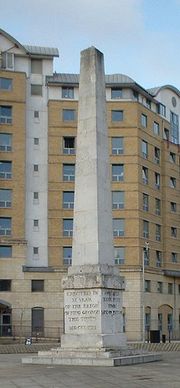
The obelisk
Obelisk
An obelisk is a tall, four-sided, narrow tapering monument which ends in a pyramid-like shape at the top, and is said to resemble a petrified ray of the sun-disk. A pair of obelisks usually stood in front of a pylon...
at St George's Circus
St George's Circus
St George's Circus is a road junction in Southwark, London, England. At its centre, which is now a traffic roundabout, is a historic obelisk, designed by Robert Mylne , in his role as surveyor and architect of Blackfriars Bridge.-History:...
was built in 1771 in honour of Brass Crosby
Brass Crosby
Brass Crosby was an English radical lawyer, Member of Parliament and Lord Mayor of London.-Life:Brass Crosby was born in Stockton-on-Tees in 1725. He qualified in law and came to London to practise his chosen profession. In 1758 he was elected to the City Council and elected 'lay' Sheriff in 1764...
, the Lord Mayor of the City of London. It was moved to the north apex of Geraldine Mary Harmsworth Park, (the remnant of Multon Close) a short distant southwest, in front of the museum, in 1905, and put back in its original spot in the late 1990s.
St. George’s Church at St. George’s Fields, Southwark, was considered the most important Catholic Church in the country when it was built. It could seat about 3,000 persons, and the building was 240 feet long by 72 feet wide. The church was solemnly opened by Bishop Wiseman on 4 July 1848. To mark the occasion Pope Pius IX sent a golden chalice and paten as a gift. Two years later Pope Pius restored the English hierarchy and St George's was chosen as the Cathedral Church of the new Diocese of Southwark, which was to cover the whole of Southern England. For the next half-century, until the opening of Westminster Cathedral, St George's was the centre of Catholic life in London.