
Springside, Ayrshire
Encyclopedia
The village of Springside is in North Ayrshire
, Parish of Dreghorn
, Scotland
. It is three miles from Irvine
, 1½ miles (2.5 km) west of Crosshouse and four miles from Kilmarnock
. In the 18th, 19th and mid 20th centuries the locality was a highly industrialised coal mining
district. The settlement is on the Garrier Burn
, which forms the boundary with East Ayrshire
. Springside had a population of around 1364 in 1991. The A71
now bypasses the village, ¼ mile (0.5 km) to the south.
 Springside (NS370386) lies on the old main road from Irvine to Kilmarnock, with a junction for Cunninghamhead
and Stewarton
district. A minor road branches off for Busbiehill and Knockentiber
. A milestone
stood near the small shop at the junction of the road leading up to the primary school.
's map of 1604 and on Armstrong's map of 1775, showing its antiquity. 1775 map. The name infers church ownership, possibly through a feudal grant of land by a local baron in pre-reformation times.
Part of the reason for the development of Springside was to cater for travelers on the roads, with the Croft Inn being built by the Bankhead family from Northern Ireland
in the 17th century to cater for the stagecoach routes from Kilmarnock to Irvine and Stewarton to Troon. This survives as Scott's Corner (2007). The Bankhead area of Springside is named after them, indeed Bankhead was the main name for the area until the Royal Mail
reorganised its postal districts in the 1930s and at that point many hamlets and other localities ceased to exist officially, such as Springhill, Corsehill, and Kirklands. The easternly area of the present Springside was called Bankhead up until at least the 1921 - 1928 OS, the hamlet of Springside being originally clustered around Springside railway station
with its Springside and Kirkland miners rows.
The earliest recording of the Bankhead surname is from 1527 in Riccarton parish and there are many references to the family in Kilmaurs
/ Kilwinning
/ Irvine
in 16th and 17th-centuries. The Bankends seem to have spread originally from Ayrshire to Northern Ireland in the 17th and 18th-Centuries, with some most likely returning in the 19th-century. Documents in the National Archives showing the Springside "lands of Bankhead" date back at least as far as 1512. Bankhead is of course an exceedingly common Scottish placename in its purely descriptive context, however it is a most uncommon surname.
Laigh Milton viaduct
over the River Irvine is situated nearby. This is the oldest railway viaduct in Scotland and one of the oldest in the world.
The old school house still stands at the Overtoun end of the village, the new primary school being opened in 1979. In the last few years (2006–2007) much of the council housing on the main road near the Croft Inn has been demolished and private housing built. The tranquil rural surroundings of 2007 totally belie the industrial past of the area.
, including Carmel Bank, previously another Cuninghame property lies just up the Thorntoun Brae towards Crosshouse. It was home to various families, such as the Montgomeries, Ross's, Mures, Cuninghame's, Peebles, Wreys and Sturrocks, before becoming a school, opened by Barnardo's
in September 1971 for children with emotional difficulties aged 11 to 16 years. The school closed in 1990 and Thorntoun finally became a nursing home. The house itself was demolished shortly after the Second World War and a new building constructed.
 Warrix (now Warrick) Hill also formed part of the demesne of the De Morvilles who forfeited their lands to Robert the Bruce. Sir James, son of Sir James Stewart of Bonkill, son of Alexander the High Steward of Scotland
, obtained Peirstoun (Perceton
) and Warrixhill, and his son, also Sir James, in turn inherited. This son had only a daughter as heir and she married Sir William Douglas and thus the property passed by marriage to the Barclay's of Pierstoun. Warrixhill became divided into two and the Montgomeries of Bourtreehill
held one half whilst the Cunninghamhead family obtained the other.
In 1524 William Cuninghame inherited the lands from his father John and both parts were sold to John Edmeston, Minister of Cardross, whose son John sold them to Jonathan Anderson, a Glasgow
Merchant. William Henry Ralston, a cadet of the Ralstons of that Ilk purchased them in 1790 from John, son of Jonathan Edmeston. A nephew, Alexander MacDougal Ralston inherited in 1833. Margaret Fullarton was the wife of Alexander McDougall Ralston. They were buried in Dreghorn parish churchyard. The three sections of Peirstoun were known as Pierstoun-Barclay, Pierstoun-Blair and Pierstoun-Cunninghame. This latter portion is thought to have contained Warrickhill itself.
John Muir of Warwick Mains died in 1875. He was a private in the Ayrshire Yeomanry Cavalry and was accidentally killed by his horse. He was buried in Dreghorn Parish Churchyard.
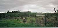
mineral railway lines, criss-crossing the countryside; they all now lifted, with only a few embankments left to indicate their original course. In 1860 numerous old and current coal pits dotted the area. The waste bing of Springhill (Pit No.3) still lies close to Springside in the field that may have been the Thorntoun deer park. Muirside pit was situated near to the Kirkland miners' row. The access track from Overtoun road is still in use today and is known as the 'pit road'.
The Corsehill tileworks made tiles for drainage and the excavation of clay lead to the creation of several large ponds. Swans nested on an islet in one of these ponds and a local football team from the area was called "The Swans". Some of the flooded claypits remain as part of a walkway and community woodland.
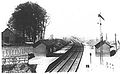 Springside railway station
or Halt opened in 1890, and closed permanently to passengers on 6 April 1964. The station never had any freight facilities and trains ran from Kilmarnock to Ardrossan where they connected up with Clyde coast steamer services to Arran and Millport. The route had ten return journeys a day in its last timetable before closure. The railway went under the road, however the cutting has been infilled and the whole line from Crosshouse railway station
and Busbie junction to Irvine is now a Sustrans
cycle path and walkway.
At the foot of Thorntoun Brae, just before the Garrier Burn on the right looking towards Thorntoun, was the site of the curling pond.
Springside had a boxing club. Jackie Paterson
was born in Springside in 1920 and went on to become Flyweight champion of the World as well as British, European and Empire bantamweight champion. Jackie died in 1966 after emigrating to South Africa.
Strawhorn states in 1951 that a fair number of inhabitants are of Cornish
extraction, having been brought up here to break a coal workers strike in the 1880s. They brought names like 'Chynoweth' with them, pronounced 'She-no-ef', Cornish
or Kernewek for 'New House'.
Messrs. Archibald Finnie and sons have a rental income of £158 10s 0d in 1912.
Quoiting
was a favourite sport in the mining community. The quoiting ground lay near the Springhill Institute.
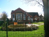
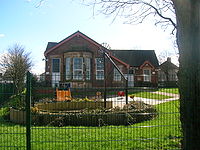
The Springhill Institute is said to have been erected around the 1840s and used to be the Miner's Welfare Institute. Archibald Finnie of Springhill House had the building constructed and it remained the property of the Finnie family until 1952. Ayr County Council took it over and had the building refurbished and turned it into the Springside Community Centre of today. On the 1895 OS map a smithy is marked in the position where the community centre is now located, giving some doubt as to the date of the institute construction as being in the 1840s. The revised 1905 map shows the institute and a smithy to the right of it where a small housing development of that name has recently been built (2006-7).
Springside - 2007
A plant nursery used to exist between the institute and the Garrier, this is remembered in the street name 'Nursery Row'. The village was well supplied with missions, two being shown on the revised 1908 OS. One has been demolished, but the other survives as a quaint ruin in 2007. The Finnie's, coalmasters, lived at Springhill in Kilmarnock. Springhill is now a nursing home.
The 'Pit Road' led to the old Muirside Pit. running towards the cyclepath and pit remains.
'Arran View' is an example of one of the early privately owned houses built in around 1902. The land was purchased from the Finnies, owners of Springhill House, Forber House and Thorntoun House.
North Ayrshire
North Ayrshire is one of 32 council areas in Scotland with a population of roughly 136,000 people. It is located in the south-west region of Scotland, and borders the areas of Inverclyde to the north, Renfrewshire to the north-east and East Ayrshire and South Ayrshire to the East and South...
, Parish of Dreghorn
Dreghorn
Dreghorn is a village near Irvine, North Ayrshire, Scotland. This parish comprehends the old parishes of Dreghorn and Pearston, which were united in 1668. The whole of the parish was historically the property of the De Morvilles, who were Constables of Scotland and Lords of Cunninghame...
, Scotland
Scotland
Scotland is a country that is part of the United Kingdom. Occupying the northern third of the island of Great Britain, it shares a border with England to the south and is bounded by the North Sea to the east, the Atlantic Ocean to the north and west, and the North Channel and Irish Sea to the...
. It is three miles from Irvine
Irvine, North Ayrshire
Irvine is a new town on the coast of the Firth of Clyde in North Ayrshire, Scotland. According to 2007 population estimates, the town is home to 39,527 inhabitants, making it the biggest settlement in North Ayrshire....
, 1½ miles (2.5 km) west of Crosshouse and four miles from Kilmarnock
Kilmarnock
Kilmarnock is a large burgh in East Ayrshire, Scotland, with a population of 44,734. It is the second largest town in Ayrshire. The River Irvine runs through its eastern section, and the Kilmarnock Water passes through it, giving rise to the name 'Bank Street'...
. In the 18th, 19th and mid 20th centuries the locality was a highly industrialised coal mining
Coal mining
The goal of coal mining is to obtain coal from the ground. Coal is valued for its energy content, and since the 1880s has been widely used to generate electricity. Steel and cement industries use coal as a fuel for extraction of iron from iron ore and for cement production. In the United States,...
district. The settlement is on the Garrier Burn
Lambroughton
Lambroughton is a village in the old Barony of Kilmaurs, North Ayrshire, Scotland. This is a rural area famous for its milk and cheese production and the Ayrshire or Dunlop breed of cattle.-Origins of the name:...
, which forms the boundary with East Ayrshire
East Ayrshire
East Ayrshire is one of 32 council areas of Scotland. It borders on to North Ayrshire, East Renfrewshire, South Lanarkshire, South Ayrshire and Dumfries and Galloway...
. Springside had a population of around 1364 in 1991. The A71
A71 road
The A71 is a major road in Scotland linking Edinburgh with Lanarkshire and Ayrshire. It adjoins the Livingston Bypass A899.It runs south west from Edinburgh for approximately 70 miles, through Saughton, Wilkieston and south of Livingston, Whitburn and Wishaw, then by way of the Garrion Bridge,...
now bypasses the village, ¼ mile (0.5 km) to the south.
Introduction
Cunninghamhead
Cunninghamhead is a hamlet in North Ayrshire, Scotland. It was the centre of the lands of Cunninghamhead, Perceton and Annick Lodge in Cunninghame...
and Stewarton
Stewarton
Stewarton is a town in East Ayrshire, Scotland. In comparison to the neighbouring towns of Kilmaurs, Fenwick, Dunlop and Lugton, it is a relatively large town, with a population of over 6,500. It is 300 feet above sea level.Groome, Francis H. . Ordnance Gazetteer of Scotland. Pub. Caxton. London....
district. A minor road branches off for Busbiehill and Knockentiber
Knockentiber
Knockentiber is a village in East Ayrshire, Parish of Kilmaurs, Scotland. Knockentiber is WNW of Kilmarnock and 1/2 mile NE of Crosshouse. Latitude:55.6193°N Longitude:4.5455°W and . The population was 359 in 1991, however the population is much higher following the construction of several...
. A milestone
Milestone
A milestone is one of a series of numbered markers placed along a road or boundary at intervals of one mile or occasionally, parts of a mile. They are typically located at the side of the road or in a median. They are alternatively known as mile markers, mileposts or mile posts...
stood near the small shop at the junction of the road leading up to the primary school.
History
The entire parish of Dreghorn belonged in the 12th century to the De Morvilles, Lord High Constables of Scotland, from whom it passed in 1196 to Roland, Lord of Galloway. The name Kirkland is marked on Timothy PontTimothy Pont
Timothy Pont was a Scottish topographer, the first to produce a detailed map of Scotland. Pont's maps are among the earliest surviving to show a European country in minute detail, from an actual survey.-Life:...
's map of 1604 and on Armstrong's map of 1775, showing its antiquity. 1775 map. The name infers church ownership, possibly through a feudal grant of land by a local baron in pre-reformation times.
Part of the reason for the development of Springside was to cater for travelers on the roads, with the Croft Inn being built by the Bankhead family from Northern Ireland
Northern Ireland
Northern Ireland is one of the four countries of the United Kingdom. Situated in the north-east of the island of Ireland, it shares a border with the Republic of Ireland to the south and west...
in the 17th century to cater for the stagecoach routes from Kilmarnock to Irvine and Stewarton to Troon. This survives as Scott's Corner (2007). The Bankhead area of Springside is named after them, indeed Bankhead was the main name for the area until the Royal Mail
Royal Mail
Royal Mail is the government-owned postal service in the United Kingdom. Royal Mail Holdings plc owns Royal Mail Group Limited, which in turn operates the brands Royal Mail and Parcelforce Worldwide...
reorganised its postal districts in the 1930s and at that point many hamlets and other localities ceased to exist officially, such as Springhill, Corsehill, and Kirklands. The easternly area of the present Springside was called Bankhead up until at least the 1921 - 1928 OS, the hamlet of Springside being originally clustered around Springside railway station
Springside railway station
Springside railway station was a railway station serving the village of Springside, North Ayrshire, Scotland. The station was originally part of the Glasgow, Paisley, Kilmarnock and Ayr Railway.-History:...
with its Springside and Kirkland miners rows.
The earliest recording of the Bankhead surname is from 1527 in Riccarton parish and there are many references to the family in Kilmaurs
Kilmaurs
Kilmaurs is a village in East Ayrshire, Scotland. It lies on the Carmel, 21.1 miles south by west of Glasgow. Population recorded in 2001 Census, 2601- History :...
/ Kilwinning
Kilwinning
Kilwinning is a historic town in North Ayrshire, Scotland. It is known as The Crossroads of Ayrshire. The 2001 Census recorded it as having a population of 15,908.-History:...
/ Irvine
Irvine, North Ayrshire
Irvine is a new town on the coast of the Firth of Clyde in North Ayrshire, Scotland. According to 2007 population estimates, the town is home to 39,527 inhabitants, making it the biggest settlement in North Ayrshire....
in 16th and 17th-centuries. The Bankends seem to have spread originally from Ayrshire to Northern Ireland in the 17th and 18th-Centuries, with some most likely returning in the 19th-century. Documents in the National Archives showing the Springside "lands of Bankhead" date back at least as far as 1512. Bankhead is of course an exceedingly common Scottish placename in its purely descriptive context, however it is a most uncommon surname.
Laigh Milton viaduct
Laigh Milton Viaduct
Laigh Milton Viaduct is a railway viaduct near Laigh Milton mill at Gatehead in East Ayrshire, Scotland. It lies in the parishes of Kilmaurs and Dundonald, at map reference: NS 3834 3690. The viaduct was closed in 1846 when the railway line was realigned.- Laigh Milton viaduct :The stone viaduct...
over the River Irvine is situated nearby. This is the oldest railway viaduct in Scotland and one of the oldest in the world.
The old school house still stands at the Overtoun end of the village, the new primary school being opened in 1979. In the last few years (2006–2007) much of the council housing on the main road near the Croft Inn has been demolished and private housing built. The tranquil rural surroundings of 2007 totally belie the industrial past of the area.
Thorntoun Estate
Springside was close to several country estates which provided employment and contributed to the need for the establishment of rural settlements such as Springside. Thorntoun house and estateThorntoun house and estate
Thorntoun School was opened by Barnardo's in September 1971 for children with emotional difficulties aged 11 to 16 years. The school closed in 1990 and Thorntoun is now a Nursing Home. The complex lies between the villages of Springside and Crosshouse, Kilmarnock in East Ayrshire, Scotland...
, including Carmel Bank, previously another Cuninghame property lies just up the Thorntoun Brae towards Crosshouse. It was home to various families, such as the Montgomeries, Ross's, Mures, Cuninghame's, Peebles, Wreys and Sturrocks, before becoming a school, opened by Barnardo's
Barnardo's
Barnardo's is a British charity founded by Thomas John Barnardo in 1866, to care for vulnerable children and young people. As of 2010, it spends over £190 million each year on more than 400 local services aimed at helping these same groups...
in September 1971 for children with emotional difficulties aged 11 to 16 years. The school closed in 1990 and Thorntoun finally became a nursing home. The house itself was demolished shortly after the Second World War and a new building constructed.
Warwickhill Estate
Warwickhill estate was situated towards the Overtoun Miners' Row. Farms with the name Warwickdale and Warwickhill are still extant, 'Warrix' being the origin of this otherwise seemingly very English sounding name.High Steward of Scotland
The title of High Steward or Great Steward was given in the 12th century to Walter Fitzalan, whose descendants became the House of Stewart. In 1371, the last High Steward inherited the throne, and thereafter the title of High Steward of Scotland has been held as a subsidiary title to that of Duke...
, obtained Peirstoun (Perceton
Perceton
Perceton is a medieval settlement and estate in North Ayrshire, Scotland, near the town of Irvine. The old church in Perceton is one of the oldest buildings in the Irvine district...
) and Warrixhill, and his son, also Sir James, in turn inherited. This son had only a daughter as heir and she married Sir William Douglas and thus the property passed by marriage to the Barclay's of Pierstoun. Warrixhill became divided into two and the Montgomeries of Bourtreehill
Bourtreehill
Bourtreehill is a housing scheme which forms part of the Irvine New Town in North Ayrshire, Scotland.- Etymology :A 'Bour Tree' is the Ayrshire name for the Common Elder tree, Sambucus nigra, often found in the older and more biodiverse local woodlands....
held one half whilst the Cunninghamhead family obtained the other.
In 1524 William Cuninghame inherited the lands from his father John and both parts were sold to John Edmeston, Minister of Cardross, whose son John sold them to Jonathan Anderson, a Glasgow
Glasgow
Glasgow is the largest city in Scotland and third most populous in the United Kingdom. The city is situated on the River Clyde in the country's west central lowlands...
Merchant. William Henry Ralston, a cadet of the Ralstons of that Ilk purchased them in 1790 from John, son of Jonathan Edmeston. A nephew, Alexander MacDougal Ralston inherited in 1833. Margaret Fullarton was the wife of Alexander McDougall Ralston. They were buried in Dreghorn parish churchyard. The three sections of Peirstoun were known as Pierstoun-Barclay, Pierstoun-Blair and Pierstoun-Cunninghame. This latter portion is thought to have contained Warrickhill itself.
John Muir of Warwick Mains died in 1875. He was a private in the Ayrshire Yeomanry Cavalry and was accidentally killed by his horse. He was buried in Dreghorn Parish Churchyard.
The Craig Estate
The Craig estate of the Dunlop family and more recently the Pollok-Morris's, lying within the ancient Barony of Robertoun, lay just before Laigh Milton Mill and the Fairlie estate is just across the River Irvine. Craig House was at one point sold to Glasgow Corporation as a 'respite home' for mainly Glaswegian children, it became a ruin after the 'school' closed, however it has since been fully restored and converted into flats (2006).The collieries, coal pits and tileworks
The 1860, 1898–1904 and, 1911 and 1912 OS maps all show that the extent to which Springside was surrounded by collieries, coal pits and freight only railway or 'tram' lines. Collieries were located near Cauldhame farm (Cauldhame and Springhill (Pit No.4), Bankhead (one called West Thorntoun), Springhill (Pit No.1) and Springhill (Pit No.2) at Springhill, and another between Busbiehill and Warwickhill. These were all served by standard gaugeStandard gauge
The standard gauge is a widely-used track gauge . Approximately 60% of the world's existing railway lines are built to this gauge...
mineral railway lines, criss-crossing the countryside; they all now lifted, with only a few embankments left to indicate their original course. In 1860 numerous old and current coal pits dotted the area. The waste bing of Springhill (Pit No.3) still lies close to Springside in the field that may have been the Thorntoun deer park. Muirside pit was situated near to the Kirkland miners' row. The access track from Overtoun road is still in use today and is known as the 'pit road'.
The Corsehill tileworks made tiles for drainage and the excavation of clay lead to the creation of several large ponds. Swans nested on an islet in one of these ponds and a local football team from the area was called "The Swans". Some of the flooded claypits remain as part of a walkway and community woodland.
Miner's rows
Springside had many, built by the mine owners for their workers. Corsehill, Sprigside and Bankhead were constructed by J & R. Howie, Archibald Finnie & Sons and A. Kenneth & Sons. Others rows were at nearby Overtoun, also Warwickhill row, and Kirkland row.The railway
Springside railway station
Springside railway station was a railway station serving the village of Springside, North Ayrshire, Scotland. The station was originally part of the Glasgow, Paisley, Kilmarnock and Ayr Railway.-History:...
or Halt opened in 1890, and closed permanently to passengers on 6 April 1964. The station never had any freight facilities and trains ran from Kilmarnock to Ardrossan where they connected up with Clyde coast steamer services to Arran and Millport. The route had ten return journeys a day in its last timetable before closure. The railway went under the road, however the cutting has been infilled and the whole line from Crosshouse railway station
Crosshouse railway station
Crosshouse railway station was a railway station serving the village of Knockentiber and nearby Crosshouse, East Ayrshire, Scotland. The station was originally part of the Glasgow, Paisley, Kilmarnock and Ayr Railway.-History:...
and Busbie junction to Irvine is now a Sustrans
Sustrans
Sustrans is a British charity to promote sustainable transport. The charity is currently working on a number of practical projects to encourage people to walk, cycle and use public transport, to give people the choice of "travelling in ways that benefit their health and the environment"...
cycle path and walkway.
The turnpike
Springside was on a toll road or turnpike. The name 'Turnpike' originated from the original 'gate' used being just a simple wooden bar attached at one end to a hinge on the supporting post. The hinge allowed it to 'open' or 'turn' This bar looked like the 'pike' used as a weapon in the army at that time and therefore we get 'turnpike'. The term was also used by the military for barriers set up on roads specifically to prevent the passage of horses. In addition to providing better surfaces and more direct routes, the turnpikes settled the confusion of the different lengths given to miles, which varied from 4,854 to nearly 7,000 feet. Long miles, short miles, Scotch or Scot's miles (5,928 feet), Irish miles (6,720 feet), etc. all existed. 5,280 feet seems to have been an average. Another important point is that when these new toll roads were constructed the Turnpike Trusts went to a great deal of trouble to improve the route of the new road and these changes could be quite considerable as the old roads tended to go from farm to farm, hardly the shortest route. The tolls on roads were abolished in 1878 to be replaced by a road 'assessment', which was taken over by the County Council in 1889.Farms
Springhill farm no longer exists, being situated where the main road houses are now. Sprimgside farm is still surrounded by open fields and the well established Kirkland farm is just across the Garrier Burn on the road to Busbiehill.Springside primary school
The local primary school was threatened with closure by North Ayrshire Council in 2008 and staff, pupils, parents and local people launched a vigorous campaign to save it. The campaign was featured on national television, local press, etc.Micro history
The County Council in 1932 planned to demolish most of the old miners' rows and this was largely carried out with new housing erected.At the foot of Thorntoun Brae, just before the Garrier Burn on the right looking towards Thorntoun, was the site of the curling pond.
| Etymology |
| The Garrier's name is thought to be derived, according to McNaught, from the Gaelic 'ruigh or righ' meaning 'fast running water' The Scots word 'Gaw' is also the term given to a 'cut made by a plough' or a furrow or channel made to draw off water. |
Springside had a boxing club. Jackie Paterson
Jackie Paterson
Jackie Paterson was a Scottish boxer who was world flyweight boxing champion. He was also British champion at flyweight and bantamweight.-Early life:...
was born in Springside in 1920 and went on to become Flyweight champion of the World as well as British, European and Empire bantamweight champion. Jackie died in 1966 after emigrating to South Africa.
Strawhorn states in 1951 that a fair number of inhabitants are of Cornish
Cornish people
The Cornish are a people associated with Cornwall, a county and Duchy in the south-west of the United Kingdom that is seen in some respects as distinct from England, having more in common with the other Celtic parts of the United Kingdom such as Wales, as well as with other Celtic nations in Europe...
extraction, having been brought up here to break a coal workers strike in the 1880s. They brought names like 'Chynoweth' with them, pronounced 'She-no-ef', Cornish
Cornish language
Cornish is a Brythonic Celtic language and a recognised minority language of the United Kingdom. Along with Welsh and Breton, it is directly descended from the ancient British language spoken throughout much of Britain before the English language came to dominate...
or Kernewek for 'New House'.
Messrs. Archibald Finnie and sons have a rental income of £158 10s 0d in 1912.
Quoiting
Quoits
Quoits is a traditional game which involves the throwing of metal, rope or rubber rings over a set distance, usually to land over or near a spike . The sport of quoits encompasses several distinct variations.-The history of quoits:The history of quoits is disputed...
was a favourite sport in the mining community. The quoiting ground lay near the Springhill Institute.
The Springhill Institute is said to have been erected around the 1840s and used to be the Miner's Welfare Institute. Archibald Finnie of Springhill House had the building constructed and it remained the property of the Finnie family until 1952. Ayr County Council took it over and had the building refurbished and turned it into the Springside Community Centre of today. On the 1895 OS map a smithy is marked in the position where the community centre is now located, giving some doubt as to the date of the institute construction as being in the 1840s. The revised 1905 map shows the institute and a smithy to the right of it where a small housing development of that name has recently been built (2006-7).
Springside - 2007
A plant nursery used to exist between the institute and the Garrier, this is remembered in the street name 'Nursery Row'. The village was well supplied with missions, two being shown on the revised 1908 OS. One has been demolished, but the other survives as a quaint ruin in 2007. The Finnie's, coalmasters, lived at Springhill in Kilmarnock. Springhill is now a nursing home.
The 'Pit Road' led to the old Muirside Pit. running towards the cyclepath and pit remains.
'Arran View' is an example of one of the early privately owned houses built in around 1902. The land was purchased from the Finnies, owners of Springhill House, Forber House and Thorntoun House.