
Speir's school
Encyclopedia
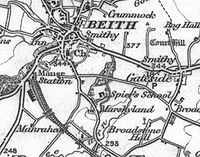
Spier's school, at Beith
, in North Ayrshire
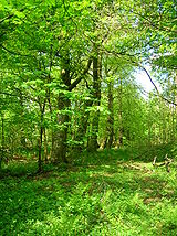
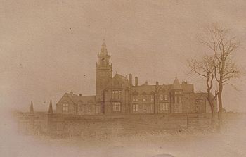
, Scotland, NS 35355327, KA15 1LU, was opened in 1888 and closed in 1972. The school, now demolished, was built using Ballochmyle red sandstone and was reminiscent of the ancient Glasgow University. The school motto was 'Quod verum tutum' (What is true is right). The gardens and woodlands are open to the public at all times.
Sustrans
National Route 7 at Kilbirnie Lochside is the nearest cycle-route access. The Barrmill Road entrance is on the bus route from Beith to Barrmill.
 Roy's map of 1747 refers to the site as Marchland, indicating that the farm lay on the boundary or march of the Barony of Broadstone within the Lordship of Giffen
, and the Barony of Beith
, the physical boundary being formed by the Powgree Burn at this point, which is also recorded as the Powgreen or Marshyland burn. Marshalland lay within the Barony of Broadstone. Later maps refer to the site as Marshyland and Marshalland.
The land upon which the school was built in 1858 only shows the presence of two wells and the fields of the old Marshalland farm with its tree lined hedgerows. Tom Paterson and his sister farmed Marshalland in the 50s, however the last people to live at Marshalland were David and Mary Kerr, the fine house and associated farm buildings being demolished in the early 1960s.
In 1686, John Shedden, ancestor of the Sheddens of Morrishill in Beith, obtained the 14s Lands of Marsheland (sic) from Hugh and John Lyle. He also obtained the 32 Penny Land of Erestoun's Mailling or Burnside of Marsheland. Robert Service bought Marsheland and passed it on to his son Robert. In 1816-17 Robert sold it on to Robert Spier, father of John Spier. Matthew Montgomerie of Bogston's daughter Margaret married John Shedden circa 1700.
A John Shedden of Marsheland (Sic), born 25 April 1756 was locally known as 'Jack the Marsheland'. He was a notorious poacher and had various brushes with the law. He had to leave the area for a while and became a game-keeper, his local nickname adapting itself to become 'Jack the Gem-Keeper.' When he died he had a friend fire a shotgun over his grave, much to the surprise and consternation of the minister.
In around 1820 the part of the Marshal-land (sic) held by Robert Spier had a rent value of £58 18s 2d, whilst that part held by Mrs.Gibson was valued at £20 0s 0d. Aitken's 1829 map shows an R. Spier Esquire as resident at Marsheyland (sic). Andrew Spier, John's brother, is designated 'of Marshalland' and may have lived there until his untimely death. A Marshall family were blacksmiths in Gateside
for many generations however no direct connection has been shown to exist.
 John Spier was the son of Robert Spier, Writer and bank agent in Beith, owner of the Marshalland and Cuff estates, which included Bogstone, Bellcraig, Eastend of Shutterflat and Lugton Ridge farms. Robert was descended from the Spier's of Kersland Mill, which he purchased from his elder brother and through good business accumen accumulated a considerable fortune of £40,000 in land and money.
John Spier of Cuff predeceased his mother, dying in 1858 at the age of 28 in Largs
; Margaret Gibson Spier (died, possibly from a carriage accident, in 1870), also from a local family, who followed his wishes and erected a school as a memorial to her son at a cost of £12,000.Groome, Francis H. (1903). Ordnance Gazetteer of Scotland. London : Caxton. p. 138. Andrew Spier of Marshalland, John's brother, had also pre-deceased his mother and brother. After many discussions and a Royal Commission investigation, the final plan for a school emerged as a co-educational day school equipped to take a few boarders.
These boarders were always a minor element, never more than 14. They lived in the Head Master's house and wore kilts on weekdays and Eton suits and hats on Sundays. Fees were 50 guineas for full-time boarders; 40 for weekly boarders; and 6 guineas per annum for day-scholars. The 1914-18 War and the shortage of domestic staff resulted in the cessation of boarding at the school. Fees
were charged at Spier's, however free education was available to local pupils who passed the qualifying examinations and were recommended by their teachers.
The school's foundation stone was laid in September 1887 in front of more than 1000 visitors and opened on 22 September 1888 with 140 pupils, mostly from North Ayrshire. The boys were taught apart from the girls until 1893 when the extra costs forced a more liberal approach to emerge. Mr. R. Bruce Lockhart from Waid Academy
was the first Head Master, followed by Dr Third in 1895. The school administration was in the hands of the Lord Lieutenant of the County, seven representatives of the school boards and the existing trustees as life governors, to be replaced by two heritors of the parish of Beith in due course.
The peak school roll was 310 in 1933 and over 350 after new classrooms were added. By 1932 however the school was in financial difficulties and after a prolonged campaign the County Authorities took over the school in 1937. In 1968 the staff consisted of 19 full-time and four itinerant teachers in the Secondary department and two in the preparatory. The school had three 'houses' to which pupils belonged, Cuff, Spier's and Marshalland. The school closed on 30 June 1972 when a modern Garnock Academy was erected at Kilbirnie, taking in the secondary pupils from Spier's, Kilbirnie Central, and Dalry High.
The headmasters were R. Bruce-Lockhart (1888–1895), Dr J. A. Third (1895–1919), Alexander Emslie (1919–1921), Gilbert R. Mair (1921–1937), Robert R. Fairley (1937–1963), and David K. Conn (1963–1972).
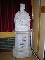
Some of the ornamental stonework was recovered after demolition and now lies near the staff car park at Garnock Academy, Kilbirnie
; some of the stones were erected in a commemorative seat. The Speir's school rector's table and chairs, together with a stained glass window and the John Spier statue are also at Garnock Academy.
The school motto was 'Quod verum, tutum' (Anonymous), meaning What is true is right.
 Margaret Gibson Spier's disposition and settlement of 19 March 1869 states that at first a ragged or charitable school near Glasgow was proposed and only later was a school in Beith parish settled on. John Spier, eldest surviving son of Margaret, intended that the school would be a memorial for himself; his mother saw the school as a memorial for her family name, construction to begin within a year of her death. The school would take any religion, except Roman Catholics and a maximum of 24 students, who were not to have pauper or tradesmen parents. Teachers and other staff were to be dismissed if they married, were to retire at 60 with no pension from the trust and if ill they were to pay for a teacher to cover their duties, again no Catholics were to be employed and the Beith presbyterian minister was to make weekly visits of inspection.
John Thomas Rochead
of Glasgow was to have been the architect of the school and a very specific requirement was that 'Binny' stone for Edinburgh was to be used in the construction if at all possible. William Brodie was to be the sculptor of the Spier memorial statues and an Italian sculpture of the 'Graces and two cupids', favourite of John spier, was to be permanently housed in the Spier's school board room.
, Dalry
, Dunlop
, Kilbirnie
and Neilston
. The Trust derives its income from the investment proceeds of the capital of the Trust and from the rental derived from letting for grazing 48.26 acres (195,301.5 m²) of land adjacent to the former school grounds. The Spiers Trust committee meet twice a year to give out small bursaries to qualifying local students. The Trust committee is made up of the local councillors from Beith, Dalry and Kilbirnie and is currently chaired by Councillor John Bell. The total area was 76.3 acres (308,775.4 m²). North Ayrshire Council now lease the school grounds from the Trust for a nominal rent.
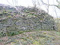
 The Barrmill Road entrance is stylistically of 17th century style, comparable to those at Moray House of 1628 in the Canongate, Edinburgh. The entrance is a C Listed structure, as are the bopundary walls and the two other gates. The total length of the boundary walls is 937 metres.
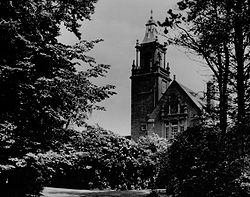
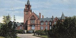
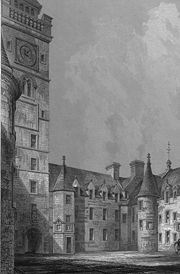
Spier's school or college when first completed had a 100 feet (30.5 m) belltower, hall, boardrooms, 10 classrooms and school-house all designed in the 17th-century style by Campbell Douglas and James Sellars, a Glasgow architectural firm. James Sellars died before the school was completed. The old seal of the governors and a stained glass window (now in Beith Primary School) depicting the seal, shows that a "French middle point" design had originally been intended. The buildings actually constructed were also on a smaller scale than had been intended. The cost was £12,000. An Art room, gymnasium and a Science room were added in 1908, during Dr Third's time. Four Horsa classrooms were added after 1945, being built on the site of the Head Master's garden or orchard. Electricity was installed once the Ayrshire Education authority took charge, however after closure on 30 June 1972 the buildings were subject to vandalism and all the buildings were demolished in 1984.
The Spier's Trust Working Group and the Regional Council made various attempts to find a new use for the buildings, even employing ASSIST, a Glasgow Architectural practice, in 1981. Many suggestions were made, ranging from Country Club to sports academy, but none were ultimately successful for this category 'B' listed building. One proposal, The Spier's Centre, would have had facilities for show jumping, a dry-ski slope, saunas, a solarium, stables, a heritage centre, a cafe, Park Ranger's office, etc. costing £730,000.
The John Spier memorials were moved to the Old Kirk in Beith in the same year. The large statue of John Spier which used to stand outside the rector's office was moved to Garnock Academy. The gate piers are C-Listed and the 'tops' were known as the 'Dunces' Caps' by the pupils.
A separate 'Janitor's or Caretaker's' house existed; last occupied by a Mrs.Rae.
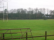
 Spier's had a great reputation for playing sports and it was the first school in Ayrshire to play rugby football, as R. Bruce Lockhart, the first headmaster, was a former Vice President of the Scottish Rugby Union. The first game was played at Marshalland on 30 October 1890. As stated, the school had a house system, with Cuff, Marshalland and Spier; providing competition on the school sports days held in June on the Marshalland playing fields. Tennis, cricket, hockey, net ball and golf were played and a quaint game called targette was played in the early days.
The Old Spierian Football Club, later the Old Spierian Rugby Club, came into existence in 1890. The Garnock Rugby Club
came into existence in 1972 as a result of the closure of Spier's and Dalry schools. G.G.H. Johnstone, a maths teacher at Spier's, had founded the rugby club for former pupils and continued his involvement until his death in 1973, at the age of 93. Old Spierians, A.Frew, J. H. Bruce Lockhart, and David Shedden were capped for Scotland.
The 7.28 acres (29,461.1 m²) 'Marshland' (Sic) playing fields are mainly used for football now and facilities are provided in the form of large metal trans-shipment containers based at the car park. A wooden games pavilion existed here in the days of the school.
Seventy Old Spierians made the supreme sacrifice and the War Memorials were a central feature of the old school buildings. The memorial is now in storage at the North Ayrshire Museum in Saltcoats
, awaiting a suitable location for re-erection.
 The Royal Caledonian Horticultural Society list Spier's as an important designed landscape.
The Earl of Eglinton's head gardener at Eglinton Castle
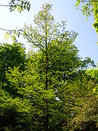
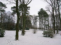
laid out the 16.53 acres (66,894.6 m²) of policies (from the Latin word politus meaning embellished) and gardens. He used a variety of trees and shrubs, especially holly varieties, eventually producing a very fine setting for the school; much of the plantings remain to this day (2008). There were between 50 and 100 varieties of trees within the grounds of Spier's and they used to be labelled with their botanical names.
A 'Coronation Garden' was established here in 1953. The site was close to the tennis lawns which lay next to the school on the Geilsland Road side.
This 1953 Coronation Garden was created with the central feature of the newly discovered 'Living Fossil' tree, the Dawn Redwood. This tree is very slow growing; it was surrounded by a key shaped edged path network with other ornamental plantings. It was damaged at the top during a money raising drive to fell trees for firewood for sale.55°44.713′N 4°37.505′W
The walled garden area, later used for extra classroom space, was originally an orchard; the entrance off the old Tennis Lawns was used by the female pupils only. The site near the Broadstone Arch with three sides formed from a yew hedge was the World War II memorial garden.
The altitude of the site is between 95 m and 100 m.
The area of woodland near the back entrance to Geilsland School is dominated by a ground layer of ivy and was known as the 'Ivy Palace' to the pupils of Spier's.
The ornamental plantings include the Laurel-leaf Holly
(Ilex aquifolia laurifolia), Highclere Holly, (Ilex aquifolia Hodginsii), Horse Chestnut, Cedar of Lebanon55°44.720′N 4°37.479′W, Yew, the large leaved Persian Ivy
(Hedera colchica), Cherry Laurel
, Lime, Holly, Scot's Fir, Dawn Redwood
, Ash, Monkey Puzzle, Great Leopard's-Bane (Dornicum pardalianches), Turkey Oak, Portuguese Laurel and Rhododendron ponticum
.
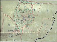
A fine boundary wall surrounds the 16 acres (64,749.8 m²) site, punctuated by gates which led onto the track which ran on the field's side or onto Barrmill and Geilsland Roads respectively. This wall was extensively repaired and rebuilt by a volunteer, Derek Graham, 2010-11.
The Spier's Trust also owns 48.26 acres (195,301.5 m²) of grazing land adjacent to the school grounds, including the High Field of 7.25 hectares lying within the school grounds.
The locals know the Powgree as the Geilsland burn and boys used to play a game of jumping across it from the Broadstone Bridge area down to Marshalland Bridge. The girls used to play in a small area nearby called the 'Fairy Glen.' Robert Aitken on his map of 1827 gives the name as Polgree Burn.
A small cottage near Broadstone Bridge stood near to an old mill and was called 'Crooked Dam' as marked on the 1850s OS map.
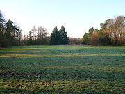
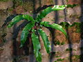
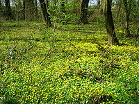
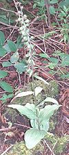 The grounds had previously been the farmland of Marshalland farm and the evidence from OS maps does not show the presence of any old woodland after the mid-eighteenth century. Several orchid species are present and a few of the indicators species of older woodland. Ivy dominates the ground flora near the Geilsland Road to the extent that almost all other species are eliminated.55°44.781′N 4°37.384′W
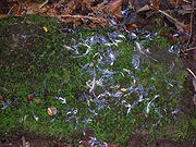
(SWT) have surveyed the grounds and recorded 19 species of birds and 136 species of plants. The grounds have a rich fungal flora, partly due to the quantity of fallen timber. This is exemplified by the presence of Parrot Waxcap (Hygrocybe psittacina
), an uncommon species. The biodiversity and other considerations have resulted in the grounds qualifying as an official SWT Wildlife Site, code NS353532. This ensures a greater degree of protection against any possibly insensitive developments that might be proposed at any future date. In 2010 a specimen of the Arran Whitebeam, Sorbus pseudofennica
, a rare species unique to Scotland, was found at Spier's.
The grounds also qualify as a Local Biodiversity Site (LBS). The Scottish Ornithologists Club (SOC) have identified Spier's as a site for birdwatching with, amongst others, tits, finches, thrushes, greater spotted woodpecker, chiffchaff, blackcap, willow and garden warbler. An unusual bird migrant record for the school grounds in the 1920s is that of the Mealy Redpoll
, Carduelis flammea flammea. It breeds across the northern parts of North America and Eurasia.
. NACs Streetscene (Grounds Maintenance) Section maintain the grounds of the parkland, mowing grass, removing fallen trees and they also use the site for In Service Training sessions.
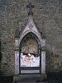
 The Spier's Memorial, now at Beith Auld Kirk, described as a "Monumental Shrine" in the RSA Exhibition of 1861, was designed by Frederick Thomas Pilkington
, and sculpted by William Brodie
. It was originally in the school yard, but later it was incorporated into Campbell Douglas & Sellars school building.
The school is remembered in 'Spiers Avenue' on the Kilbirnie Road. Part of the unmetalled road that runs from Fairholm (Craigvue) down towards Craig House is known as Spiersland Way; the latter part is known as Roughwood Road after the farm of that name. A Spier's care Home also exists in Beith.
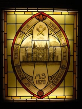
Beith Primary school has a 'Spier's Library', a painting of the school and a stained glass window depicting the alternative design of the school, never built, but used on the Governor's official seal. It is dated 1870, 18 years before the school was completed. Gateside Primary school has a Spier's House as well as a Cuff House.
The old War Memorial from Spier's is presently in storage at the North Ayrshire Museum in Saltcoats; the John Spier memorials were moved to the Old Kirk in Beith and the large statue of John Spier's was moved to Garnock Academy.
Garnock Academy holds the details of the grant of a Coat of Arms to Spier's, a number of stained glass windows, a mineralogical collection and the rector's old table and chairs from the study. It may also hold the Governor's seal.
is in of four in the Spier's and Marshalland woodlands and their co-ordinates can be found by registering on the Geocaching website, where other local caches can be found and comments added. A GPS handset is the quickest way to locate these caches.
A CITO (Cache In Trash Out) event was held at Spier's in 2010 with 58 'cachers' clearing litter and hunting for the caches.
 This was a half merk land, part of the 4 merk land of Marsheland, in the Barony of Braidstone. It was sold in four lots. In 1867, two of these lots were purchased by Wiliam Fulton Love, writer and bank agent in Beith. He built a handsome villa, in the domestic gothic style, and enclosed and planted with much taste, 5 acres (20,234.3 m²) around the villa. This property is now part of Geilsland school, run by the Church of Scotland under its 'Crossreach' initiative. The name is pronounced 'Jillsland' locally. The origin of the name may refer to a gil or gyll, referring to a cleft or ravine as found at the 'Fairy Glen' where the Powgree Burn cuts through the fields.
Pupils from Geilsland have helped to improve the grounds of Spier's by carrying out conservation projects.
lies close to Broadstone and Geilsland. It has a fine pub, primary school, plant nursery, Millennium garden, and the Isobel Patrick of Trearne Memorial Hall. Until recently it had a smithy. Trearne House stood nearby and was demolished, the site is now a large limestone quarry.
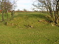 A Moot hill
or Court Hill survives near Boghall in the old Barony of Beith. Dobie states that the Abbot of Kilwinning used it to administered justice to his vassals and tenants. It is a sub-oval, flat-topped mound, situated at the foot of a small valley. A number of large stones are visible in the sides of the mound. It is turf-covered, situated on a low outcrop, and is mostly an artificial work. It pre-dates the channelling of the burn which detours around it, the mound was probably isolated in this once marshy outflow of the former Boghall Loch (see NS35SE 14). It does not seem to lie in the area identified by Smith.
, later a direct junction was laid. The line did not survive into the 20th century. The road nearby is still known as 'Reek Street'.
, an igneous basalt
. The whinstone is therefore derived from volcanic activity and often shows itself as 'dikes' which are usually linear seams of hardened lava which was originally pushed up through the overlying limestone or coal. Coal miners were greatly incovenienced by these hard dikes.
The basalt at Spier's has many distinctive holes or bubbles, known as vesicles. These formed when gases such as steam and carbon dioxide escaped as the compressive pressure got less in the molten rock as the lava reached the surface. The largest numbers of bubbles occur when the hardened skin of the lava surface prevented the bubbles from rising to the surface and bursting. Olivine
crystal faces are visible, a mineral rich in silica, iron and magnesium. The size of the faces shows that the lava cooled relatively slowly, allowing the crystals time to 'grow'.
Spier's is close to the limestone quarries of Broadstone, Hillhead, Middleton, Dockra and Trearne. Whinstone has been quarried along a dike at Barrmill and is still quarried (2011) at Loanhead.
, munitions store, for the Royal Navy
. It now processes and stores Spearfish, Storm Shadow
, Tomahawk
and Brimstone
missiles. The school lay within the 'Exclusion Zone', limiting new housing developments, etc.
John Spier owned Cuff estate and through his marriage to Margaret Gibson acquired the estate of Marshalland. In 1870 Margaret Spier died and Whang House was purchased by by a Thomas Miller.
In 1935 a cannon was located at the front of the school as seen in a photograph taken at that time.
The annual Cadger's races of the 19th century were held at the Marshalland Field.
The name 'Pow' or 'Poll' refers to a slow-moving ditch-like stream and this may be appropriate in regard of the name of the burn, the Powgree.
On May 11th 1912 an official inspection by the governors took place of the farms owned by the Spier's Trust, these being Cuff, Marshyland, Bellcraig, Bogston, and Lugtonridge.
A Spier's Knowe is marked on Windy Hill above Largs on the Muirshiel Hills.
 In 1834 Cholera broke out in Beith
and although 'clothes were burned, bedding fumigated, stairs and closes whitewashed, a nurse who was a veteran of the Dalry
outbreak was engaged and a ban placed on entertainments at funerals.' There were 100 cases in September 1834, 205 people were eventually affected with 105 deaths. Some of the people were buried in the Parish Churchyard, but others were buried in a field, close to what became Spier's School, on the little common south-west of where the Geilsland Road meets the Powgree Burn. Robert Spier, the father of John Spier, was a member of the local Health Board.
The 1st Beith Company (Spier's) Girl Guides was in the 1930s the only Guides group in Beith and was based at Spier's.
The Girl Guides had a centre in the field next to the school for some years; the Spier's Trust having sold them 2.2 acres (8,903.1 m²). This building was repeatedly vandalised. The site was sold and a dwelling built, but after two fires this was also demolished. Only a small building remains, also vandalised.
The 'Old Spierian' records that transport to the school was a regular and severe problem. The 'train students' in particular had to leave home very early and return late.
The 1910 OS map shows a 'Sheepwash' nearly opposite the side entrance to Marshalland farm. A house on the Barrmill Road where it joins the Beith bypass has the unusual name of 'Bellscauseway'. During the depression in the 1930s, times were hard and local people would go up to Spier's School to gather wood for the fire, but as often as not they got 'hunted' by the janitor. A mineral spring known as 'Spiers Well' existed near Gatehead
in 1789.
The ghost of John Spier was said to roam the school tower, possibly to discourage students from exploring it, and that of his mother, Margaret Spier, the school grounds. The ornate memorial to John Spier was partitioned off due to its depressing effect on the students.
The Pirritt Hills in Antarctica are named for John Pirritt, Old Spierian, explorer and geologist.
The Powgree Burn name may translate as 'water or marsh (Pow) in an enclose area (Gree)' which is a good description of the area below the Hill of Beith where the Powgree has its source.
Donald Reid records that the school grounds were enclosed and laid out by Mr W. F. Love of Beith.
 In 2008 Beith Community Council organised a Spier's School grounds tidy up and improvements morning. Litter was removed and an old path was cleared to allow better access to the site for local people and visitors to the area. Gateside Primary school have planted trees and bulbs donated by the community and Eglinton Country Park
. Ardrossan Academy pupils have opened up new paths through the woods and the grounds.
The 'Youth Making Beith Better' group have carried out path maintenance and other grounds improvements works at Spier's through their John Muir Award work. Ken Stewart of Dalry brings Wesley, his Clydesdale horse, to extract logs from the woodlands, providing a spectacle for visitors and removing fallen timber with minimal damage to te habitats. Beith Out of School Care have produced publicity posters for the site and the YKG youth group have had a BBQ and have planted trees. Geilsland School
is involved in several projects within the parklands.
A Sustainable Return on Investment (SRoI) project is being trialed at Spier's, organised by the Greenspace group and part finnaced by Scottish Natural Heritage.
FoS encourages other groups to become involved at Spier's through membership, carrying out conservation projects; biodiversity enhancement initiatives; photographic and other surveys; as well as arranging events and furthering the educational and ecotherapeutic uses of the Spiers woodlands and open spaces.
The first substantial sign of the regeneration of the site was the construction of the Spier's Commemorative Wall, erected in 2010.
Sixty Ayrshire Geocachers, Friends of Spiers (FoS) and Youth Making Beith Better carried out a thorough CITO (litter pick and cache search) and Action Earth project at Spier's in April 2010.
Thirty-five guests and visitors attended the official unveiling of the Spier's commemorative stone on April 18, 2010. The FoS carried out their first practical conservation workday on the same day and the NAC Ranger Service organised a spring walk.
of the Gibson family gives the date 1767 and may have come from an older mansion house once situated nearby. The farm still has many ornamental and functional entrance gates and gateposts from the Victorian era and magnificent lanes lined with beech trees. Margaret Gibson was an heiress and her son John Spier lived at The Cuff prior to his early death. The Spier are also said to have owned Cuff estate and through Robert Spier's marriage to Margaret Gibson acquired the estate of Marshalland.
Beith
Beith is a small town situated in the Garnock Valley in North Ayrshire, Scotland approximately 20-miles south-west of Glasgow. The town is situated on the crest of a hill and was known originally as the "Hill o' Beith" after its Court Hill.-History:-Name:Beith's name is thought to emanate from...
, in North Ayrshire
North Ayrshire
North Ayrshire is one of 32 council areas in Scotland with a population of roughly 136,000 people. It is located in the south-west region of Scotland, and borders the areas of Inverclyde to the north, Renfrewshire to the north-east and East Ayrshire and South Ayrshire to the East and South...
, Scotland, NS 35355327, KA15 1LU, was opened in 1888 and closed in 1972. The school, now demolished, was built using Ballochmyle red sandstone and was reminiscent of the ancient Glasgow University. The school motto was 'Quod verum tutum' (What is true is right). The gardens and woodlands are open to the public at all times.
Sustrans
Sustrans
Sustrans is a British charity to promote sustainable transport. The charity is currently working on a number of practical projects to encourage people to walk, cycle and use public transport, to give people the choice of "travelling in ways that benefit their health and the environment"...
National Route 7 at Kilbirnie Lochside is the nearest cycle-route access. The Barrmill Road entrance is on the bus route from Beith to Barrmill.
Marshalland
Barony and Castle of Giffen
The Barony of Giffen and its associated 15th-century castle were in the parish of Beith in the former District of Cunninghame, now North Ayrshire. The site may be spelled Giffen or Giffin and lay within the Lordship of Giffin, which included the Baronies of Giffen, Trearne, Hessilhead, Broadstone,...
, and the Barony of Beith
Beith
Beith is a small town situated in the Garnock Valley in North Ayrshire, Scotland approximately 20-miles south-west of Glasgow. The town is situated on the crest of a hill and was known originally as the "Hill o' Beith" after its Court Hill.-History:-Name:Beith's name is thought to emanate from...
, the physical boundary being formed by the Powgree Burn at this point, which is also recorded as the Powgreen or Marshyland burn. Marshalland lay within the Barony of Broadstone. Later maps refer to the site as Marshyland and Marshalland.
The land upon which the school was built in 1858 only shows the presence of two wells and the fields of the old Marshalland farm with its tree lined hedgerows. Tom Paterson and his sister farmed Marshalland in the 50s, however the last people to live at Marshalland were David and Mary Kerr, the fine house and associated farm buildings being demolished in the early 1960s.
In 1686, John Shedden, ancestor of the Sheddens of Morrishill in Beith, obtained the 14s Lands of Marsheland (sic) from Hugh and John Lyle. He also obtained the 32 Penny Land of Erestoun's Mailling or Burnside of Marsheland. Robert Service bought Marsheland and passed it on to his son Robert. In 1816-17 Robert sold it on to Robert Spier, father of John Spier. Matthew Montgomerie of Bogston's daughter Margaret married John Shedden circa 1700.
A John Shedden of Marsheland (Sic), born 25 April 1756 was locally known as 'Jack the Marsheland'. He was a notorious poacher and had various brushes with the law. He had to leave the area for a while and became a game-keeper, his local nickname adapting itself to become 'Jack the Gem-Keeper.' When he died he had a friend fire a shotgun over his grave, much to the surprise and consternation of the minister.
In around 1820 the part of the Marshal-land (sic) held by Robert Spier had a rent value of £58 18s 2d, whilst that part held by Mrs.Gibson was valued at £20 0s 0d. Aitken's 1829 map shows an R. Spier Esquire as resident at Marsheyland (sic). Andrew Spier, John's brother, is designated 'of Marshalland' and may have lived there until his untimely death. A Marshall family were blacksmiths in Gateside
Gateside, North Ayrshire
Gateside is a small village in North Ayrshire, Scotland about half a mile east of Beith on the B777.-The village:Gateside Primary School, headteacher Ms Fiona Dunlop, was opened in 1903, and nowadays it has 74 pupils...
for many generations however no direct connection has been shown to exist.
School history
John Spier of Cuff predeceased his mother, dying in 1858 at the age of 28 in Largs
Largs
Largs is a town on the Firth of Clyde in North Ayrshire, Scotland, about from Glasgow. The original name means "the slopes" in Scottish Gaelic....
; Margaret Gibson Spier (died, possibly from a carriage accident, in 1870), also from a local family, who followed his wishes and erected a school as a memorial to her son at a cost of £12,000.Groome, Francis H. (1903). Ordnance Gazetteer of Scotland. London : Caxton. p. 138. Andrew Spier of Marshalland, John's brother, had also pre-deceased his mother and brother. After many discussions and a Royal Commission investigation, the final plan for a school emerged as a co-educational day school equipped to take a few boarders.
These boarders were always a minor element, never more than 14. They lived in the Head Master's house and wore kilts on weekdays and Eton suits and hats on Sundays. Fees were 50 guineas for full-time boarders; 40 for weekly boarders; and 6 guineas per annum for day-scholars. The 1914-18 War and the shortage of domestic staff resulted in the cessation of boarding at the school. Fees
Independent school (UK)
An independent school is a school that is not financed through the taxation system by local or national government and is instead funded by private sources, predominantly in the form of tuition charges, gifts and long-term charitable endowments, and so is not subject to the conditions imposed by...
were charged at Spier's, however free education was available to local pupils who passed the qualifying examinations and were recommended by their teachers.
The school's foundation stone was laid in September 1887 in front of more than 1000 visitors and opened on 22 September 1888 with 140 pupils, mostly from North Ayrshire. The boys were taught apart from the girls until 1893 when the extra costs forced a more liberal approach to emerge. Mr. R. Bruce Lockhart from Waid Academy
Waid Academy
The Waid Academy is a public secondary school located in the town of Anstruther, Fife. The schools catchment area extends out to the area of Lundin Links and Largo but accepts pupils from town such as Leven, Kennoway and Markinch.-History :...
was the first Head Master, followed by Dr Third in 1895. The school administration was in the hands of the Lord Lieutenant of the County, seven representatives of the school boards and the existing trustees as life governors, to be replaced by two heritors of the parish of Beith in due course.
The peak school roll was 310 in 1933 and over 350 after new classrooms were added. By 1932 however the school was in financial difficulties and after a prolonged campaign the County Authorities took over the school in 1937. In 1968 the staff consisted of 19 full-time and four itinerant teachers in the Secondary department and two in the preparatory. The school had three 'houses' to which pupils belonged, Cuff, Spier's and Marshalland. The school closed on 30 June 1972 when a modern Garnock Academy was erected at Kilbirnie, taking in the secondary pupils from Spier's, Kilbirnie Central, and Dalry High.
The headmasters were R. Bruce-Lockhart (1888–1895), Dr J. A. Third (1895–1919), Alexander Emslie (1919–1921), Gilbert R. Mair (1921–1937), Robert R. Fairley (1937–1963), and David K. Conn (1963–1972).
Some of the ornamental stonework was recovered after demolition and now lies near the staff car park at Garnock Academy, Kilbirnie
Kilbirnie
Kilbirnie is a small town of 7280 inhabitants situated in North Ayrshire on the west coast of Scotland...
; some of the stones were erected in a commemorative seat. The Speir's school rector's table and chairs, together with a stained glass window and the John Spier statue are also at Garnock Academy.
The school motto was 'Quod verum, tutum' (Anonymous), meaning What is true is right.
The Spier's Institution
John Thomas Rochead
John Thomas Rochead
John Thomas Rochead was a British architect.He was born and raised in Edinburgh, and worked for a number of years as an apprentice of David Bryce...
of Glasgow was to have been the architect of the school and a very specific requirement was that 'Binny' stone for Edinburgh was to be used in the construction if at all possible. William Brodie was to be the sculptor of the Spier memorial statues and an Italian sculpture of the 'Graces and two cupids', favourite of John spier, was to be permanently housed in the Spier's school board room.
The Spier's Trust
The trust was founded in 1936 by Mrs Margaret Gibson Spier for the administration of Spier's and for the provision of educational grants and bursaries within the local area of benefit, this being the parishes of BeithBeith
Beith is a small town situated in the Garnock Valley in North Ayrshire, Scotland approximately 20-miles south-west of Glasgow. The town is situated on the crest of a hill and was known originally as the "Hill o' Beith" after its Court Hill.-History:-Name:Beith's name is thought to emanate from...
, Dalry
Dalry, North Ayrshire
Dalry is a small town in the Garnock Valley in Ayrshire, Scotland.-History:Dalry means "King's Valley" or more simply the "Rye Meadow"; indicating a small settlement on the Rye Burn. Its history has signs of early inhabitants in the area...
, Dunlop
Dunlop, East Ayrshire
Dunlop is a village and parish in East Ayrshire, Scotland. It lies on the A735, north-east of Stewarton, seven miles from Kilmarnock. The road runs on to Lugton and the B706 enters the village from Beith.-The village:...
, Kilbirnie
Kilbirnie
Kilbirnie is a small town of 7280 inhabitants situated in North Ayrshire on the west coast of Scotland...
and Neilston
Neilston
Neilston is a village and parish in East Renfrewshire set in the west central Lowlands of Scotland. It lies in the Levern Valley, southwest of Barrhead, south of Paisley, and south-southwest of Renfrew, at the southwestern fringe of the Greater Glasgow conurbation...
. The Trust derives its income from the investment proceeds of the capital of the Trust and from the rental derived from letting for grazing 48.26 acres (195,301.5 m²) of land adjacent to the former school grounds. The Spiers Trust committee meet twice a year to give out small bursaries to qualifying local students. The Trust committee is made up of the local councillors from Beith, Dalry and Kilbirnie and is currently chaired by Councillor John Bell. The total area was 76.3 acres (308,775.4 m²). North Ayrshire Council now lease the school grounds from the Trust for a nominal rent.
The Margaret Spier bequest
Recorded in the vestibule of Beith Kirk is the bequest made by Mrs Margaret Gibson or Spier, relict of Robert Spier of Marshalland and Cuff. In addition to the funds for the school she charged her lands of Cuff with a yearly payment of £25 to the Ministers of Beith Kirk. Warm clothing and coals were to be provided to the deserving poor of the town and parish. Margaret died on 17 February 1870. Margaret had also purchased the lands of Bogston and Corshole from Charlotte Decker nee Montgomerie in 1848 and these were part of the foundation endowment of Spier's school. Locally Margaret Spier was known as 'Lady' Spier. She also appears to have wanted to build a hospital, however funds were not available from her estates for such a costly enterprise.The school buildings
Spier's school or college when first completed had a 100 feet (30.5 m) belltower, hall, boardrooms, 10 classrooms and school-house all designed in the 17th-century style by Campbell Douglas and James Sellars, a Glasgow architectural firm. James Sellars died before the school was completed. The old seal of the governors and a stained glass window (now in Beith Primary School) depicting the seal, shows that a "French middle point" design had originally been intended. The buildings actually constructed were also on a smaller scale than had been intended. The cost was £12,000. An Art room, gymnasium and a Science room were added in 1908, during Dr Third's time. Four Horsa classrooms were added after 1945, being built on the site of the Head Master's garden or orchard. Electricity was installed once the Ayrshire Education authority took charge, however after closure on 30 June 1972 the buildings were subject to vandalism and all the buildings were demolished in 1984.
The Spier's Trust Working Group and the Regional Council made various attempts to find a new use for the buildings, even employing ASSIST, a Glasgow Architectural practice, in 1981. Many suggestions were made, ranging from Country Club to sports academy, but none were ultimately successful for this category 'B' listed building. One proposal, The Spier's Centre, would have had facilities for show jumping, a dry-ski slope, saunas, a solarium, stables, a heritage centre, a cafe, Park Ranger's office, etc. costing £730,000.
The John Spier memorials were moved to the Old Kirk in Beith in the same year. The large statue of John Spier which used to stand outside the rector's office was moved to Garnock Academy. The gate piers are C-Listed and the 'tops' were known as the 'Dunces' Caps' by the pupils.
A separate 'Janitor's or Caretaker's' house existed; last occupied by a Mrs.Rae.
School sports
The Old Spierian Football Club, later the Old Spierian Rugby Club, came into existence in 1890. The Garnock Rugby Club
Garnock RFC
Garnock Rugby Club is an amateur rugby union club based in Glengarnock in Scotland. They currently play in the Scottish National League Division One.-History:...
came into existence in 1972 as a result of the closure of Spier's and Dalry schools. G.G.H. Johnstone, a maths teacher at Spier's, had founded the rugby club for former pupils and continued his involvement until his death in 1973, at the age of 93. Old Spierians, A.Frew, J. H. Bruce Lockhart, and David Shedden were capped for Scotland.
The 7.28 acres (29,461.1 m²) 'Marshland' (Sic) playing fields are mainly used for football now and facilities are provided in the form of large metal trans-shipment containers based at the car park. A wooden games pavilion existed here in the days of the school.
The World Wars
The school had an unofficial cadet corps in 1914 and donated money to the Belgian Refugee Fund in 1915 and it also endowed a hospital bed in 1918. In the second world war part of the High Field was converted into a potato field as part of the "Dig for Victory" initiative.Seventy Old Spierians made the supreme sacrifice and the War Memorials were a central feature of the old school buildings. The memorial is now in storage at the North Ayrshire Museum in Saltcoats
Saltcoats
- References :*McSherry, R. & M. . Old Saltcoats, Stenlake Publishing, Ochiltree. ISBN 1-872074-57-X.*Stansfield, G. . Ayrshire & Renfrewshire's Lost Railways, Stenlake Publishing, Catrine. ISBN 1-84033-077-5.-External links:***...
, awaiting a suitable location for re-erection.
The gardens and woodlands
The Earl of Eglinton's head gardener at Eglinton Castle
Eglinton Country Park
Eglinton Country Park is located in the grounds of the old Eglinton Castle estate, Kilwinning, North Ayrshire, Scotland . Eglinton Park is situated in the parish of Kilwinning, part of the former district of Cunninghame, and covers an area of 400 hectares...
laid out the 16.53 acres (66,894.6 m²) of policies (from the Latin word politus meaning embellished) and gardens. He used a variety of trees and shrubs, especially holly varieties, eventually producing a very fine setting for the school; much of the plantings remain to this day (2008). There were between 50 and 100 varieties of trees within the grounds of Spier's and they used to be labelled with their botanical names.
A 'Coronation Garden' was established here in 1953. The site was close to the tennis lawns which lay next to the school on the Geilsland Road side.
This 1953 Coronation Garden was created with the central feature of the newly discovered 'Living Fossil' tree, the Dawn Redwood. This tree is very slow growing; it was surrounded by a key shaped edged path network with other ornamental plantings. It was damaged at the top during a money raising drive to fell trees for firewood for sale.55°44.713′N 4°37.505′W
The walled garden area, later used for extra classroom space, was originally an orchard; the entrance off the old Tennis Lawns was used by the female pupils only. The site near the Broadstone Arch with three sides formed from a yew hedge was the World War II memorial garden.
The altitude of the site is between 95 m and 100 m.
The area of woodland near the back entrance to Geilsland School is dominated by a ground layer of ivy and was known as the 'Ivy Palace' to the pupils of Spier's.
The ornamental plantings include the Laurel-leaf Holly
Holly
Ilex) is a genus of 400 to 600 species of flowering plants in the family Aquifoliaceae, and the only living genus in that family. The species are evergreen and deciduous trees, shrubs, and climbers from tropics to temperate zones world wide....
(Ilex aquifolia laurifolia), Highclere Holly, (Ilex aquifolia Hodginsii), Horse Chestnut, Cedar of Lebanon55°44.720′N 4°37.479′W, Yew, the large leaved Persian Ivy
Ivy
Ivy, plural ivies is a genus of 12–15 species of evergreen climbing or ground-creeping woody plants in the family Araliaceae, native to western, central and southern Europe, Macaronesia, northwestern Africa and across central-southern Asia east to Japan and Taiwan.-Description:On level ground they...
(Hedera colchica), Cherry Laurel
Cherry laurel
Prunus laurocerasus, with common names cherry laurel and sometimes called English laurel in North America, is a species in the genus Prunus, native to regions bordering the Black Sea in southwestern Asia and southeastern Europe, from Albania and Bulgaria east through Turkey to the Caucasus...
, Lime, Holly, Scot's Fir, Dawn Redwood
Metasequoia
Metasequoia is a fast-growing, deciduous tree, and the sole living species, Metasequoia glyptostroboides, is one of three species of conifers known as redwoods. It is native to the Sichuan-Hubei region of China. Although the least tall of the redwoods, it grows to at least 200 feet in height...
, Ash, Monkey Puzzle, Great Leopard's-Bane (Dornicum pardalianches), Turkey Oak, Portuguese Laurel and Rhododendron ponticum
Rhododendron ponticum
Rhododendron ponticum, called Common Rhododendron or Pontic Rhododendron, is a species of Rhododendron native to southern Europe and southwest Asia.-Description:...
.
A fine boundary wall surrounds the 16 acres (64,749.8 m²) site, punctuated by gates which led onto the track which ran on the field's side or onto Barrmill and Geilsland Roads respectively. This wall was extensively repaired and rebuilt by a volunteer, Derek Graham, 2010-11.
The Spier's Trust also owns 48.26 acres (195,301.5 m²) of grazing land adjacent to the school grounds, including the High Field of 7.25 hectares lying within the school grounds.
The locals know the Powgree as the Geilsland burn and boys used to play a game of jumping across it from the Broadstone Bridge area down to Marshalland Bridge. The girls used to play in a small area nearby called the 'Fairy Glen.' Robert Aitken on his map of 1827 gives the name as Polgree Burn.
A small cottage near Broadstone Bridge stood near to an old mill and was called 'Crooked Dam' as marked on the 1850s OS map.
Natural history
Wildlife Site status
The Scottish Wildlife TrustScottish Wildlife Trust
The Scottish Wildlife Trust is a registered charity dedicated to conserving the wildlife and natural environment of Scotland.-Description:The Scottish Wildlife Trust has over 32,800 members...
(SWT) have surveyed the grounds and recorded 19 species of birds and 136 species of plants. The grounds have a rich fungal flora, partly due to the quantity of fallen timber. This is exemplified by the presence of Parrot Waxcap (Hygrocybe psittacina
Hygrocybe psittacina
Hygrocybe psittacina, commonly known as the Parrot Toadstool or Parrot Waxcap, is a colourful member of the genus Hygrocybe, the waxcaps, found across Northern Europe. Originally described as Hygrophorus psittacinus, there have been at least two subspecies described, H. psittacina var. psittacina...
), an uncommon species. The biodiversity and other considerations have resulted in the grounds qualifying as an official SWT Wildlife Site, code NS353532. This ensures a greater degree of protection against any possibly insensitive developments that might be proposed at any future date. In 2010 a specimen of the Arran Whitebeam, Sorbus pseudofennica
Sorbus pseudofennica
Sorbus pseudofennica is a species of plant in the Rosaceae family. It is a naturally occurring hybrid caused by the Rock Whitebeam hybridising with the Rowan , then crossing back with S. aucuparia...
, a rare species unique to Scotland, was found at Spier's.
The grounds also qualify as a Local Biodiversity Site (LBS). The Scottish Ornithologists Club (SOC) have identified Spier's as a site for birdwatching with, amongst others, tits, finches, thrushes, greater spotted woodpecker, chiffchaff, blackcap, willow and garden warbler. An unusual bird migrant record for the school grounds in the 1920s is that of the Mealy Redpoll
Common Redpoll
The Common Redpoll is a species in the finch family. It breeds somewhat further south than the Arctic Redpoll, also in habitats with thickets or shrubs. Nominate C. f. flammea breeds across the northern parts of North America and Eurasia. There is also an Icelandic subspecies, Icelandic Redpoll...
, Carduelis flammea flammea. It breeds across the northern parts of North America and Eurasia.
North Ayrshire Council
The grounds are regularly patrolled by a Countryside Ranger from the North Ayrshire Ranger Service, based at Eglinton Country ParkEglinton Country Park
Eglinton Country Park is located in the grounds of the old Eglinton Castle estate, Kilwinning, North Ayrshire, Scotland . Eglinton Park is situated in the parish of Kilwinning, part of the former district of Cunninghame, and covers an area of 400 hectares...
. NACs Streetscene (Grounds Maintenance) Section maintain the grounds of the parkland, mowing grass, removing fallen trees and they also use the site for In Service Training sessions.
Memorials to John Spier and Spier's school
Frederick Thomas Pilkington
Frederick Thomas Pilkington was a Scottish architect, practising in the Victorian High Gothic revival style. His father was also an architect.Frederick Thomas Pilkington practised as an architect in Edinburgh from 1860 to 1883...
, and sculpted by William Brodie
William Brodie (sculptor)
William Brodie was a Scottish sculptor. He was the son of John Brodie, a Banff shipmaster, and elder brother of Alexander Brodie , another sculptor....
. It was originally in the school yard, but later it was incorporated into Campbell Douglas & Sellars school building.
The school is remembered in 'Spiers Avenue' on the Kilbirnie Road. Part of the unmetalled road that runs from Fairholm (Craigvue) down towards Craig House is known as Spiersland Way; the latter part is known as Roughwood Road after the farm of that name. A Spier's care Home also exists in Beith.
Beith Primary school has a 'Spier's Library', a painting of the school and a stained glass window depicting the alternative design of the school, never built, but used on the Governor's official seal. It is dated 1870, 18 years before the school was completed. Gateside Primary school has a Spier's House as well as a Cuff House.
The old War Memorial from Spier's is presently in storage at the North Ayrshire Museum in Saltcoats; the John Spier memorials were moved to the Old Kirk in Beith and the large statue of John Spier's was moved to Garnock Academy.
Garnock Academy holds the details of the grant of a Coat of Arms to Spier's, a number of stained glass windows, a mineralogical collection and the rector's old table and chairs from the study. It may also hold the Governor's seal.
The Spier's Geocaches
Geocaching is a popular new 'sport', akin to treasure hunting and orienteering combined, which involves searching for 'hidden' caches of 'swaps' and a log book in which comments can be left. The 'Grounds for Learning (Son of)' geocacheGeocaching
Geocaching is an outdoor sporting activity in which the participants use a Global Positioning System receiver or mobile device and other navigational techniques to hide and seek containers, called "geocaches" or "caches", anywhere in the world....
is in of four in the Spier's and Marshalland woodlands and their co-ordinates can be found by registering on the Geocaching website, where other local caches can be found and comments added. A GPS handset is the quickest way to locate these caches.
A CITO (Cache In Trash Out) event was held at Spier's in 2010 with 58 'cachers' clearing litter and hunting for the caches.
Geilsland
Pupils from Geilsland have helped to improve the grounds of Spier's by carrying out conservation projects.
Gateside Village
The village of GatesideGateside, North Ayrshire
Gateside is a small village in North Ayrshire, Scotland about half a mile east of Beith on the B777.-The village:Gateside Primary School, headteacher Ms Fiona Dunlop, was opened in 1903, and nowadays it has 74 pupils...
lies close to Broadstone and Geilsland. It has a fine pub, primary school, plant nursery, Millennium garden, and the Isobel Patrick of Trearne Memorial Hall. Until recently it had a smithy. Trearne House stood nearby and was demolished, the site is now a large limestone quarry.
The Moot Hill
Moot hill
A moot hill or mons placiti is a hill or mound historically used as an assembly or meeting place. In early medieval Britain, such hills were used for "moots", meetings of local people to settle local business. Among other things, proclamations might be read; decisions might be taken; court cases...
or Court Hill survives near Boghall in the old Barony of Beith. Dobie states that the Abbot of Kilwinning used it to administered justice to his vassals and tenants. It is a sub-oval, flat-topped mound, situated at the foot of a small valley. A number of large stones are visible in the sides of the mound. It is turf-covered, situated on a low outcrop, and is mostly an artificial work. It pre-dates the channelling of the burn which detours around it, the mound was probably isolated in this once marshy outflow of the former Boghall Loch (see NS35SE 14). It does not seem to lie in the area identified by Smith.
Quarrying
A sandstone quarry existed near to Marshalland farm and several sizeable limekilns and limestone quarries lay towards Broadstone; marble was found at Broadstone.Broadstone castle
The ruins of Braidstone or Broadstone Castle remained until about 1850. but when Broadstonehall Farm buildings were being rebuilt, the castle was pulled down and its stones used in the building works; the Broadstone Crags, the site of the castle, remain however.Broadstone or Hillhead Limekilns
The OS maps for 1858 show that the 'Hillhead Railway' ran to Broadstone quarry from Barkip Junction on the Ayrshire and Lanarkshire Railway branchline to Kilbirnie. At first sidings and a transfer system existed with a weighing machine at what was to become Brackenhills railway stationBrackenhills railway station
Brackenhills railway station was a railway station approximately one mile south-west of the town of Beith, North Ayrshire, Scotland, part of the Lanarkshire and Ayrshire Railway.- History :...
, later a direct junction was laid. The line did not survive into the 20th century. The road nearby is still known as 'Reek Street'.
Geology
Several large fallen trees at Spier's Old School Grounds have their roots embedded in rock which is derived from an old lava flow known as a 'dike,' one of a 'swarm' that exist locally. The solid geology of the Beith area is dominated by rocks such as limestone, coal, and also whinstoneWhinstone
Whinstone is a term used in the quarrying industry to describe any hard dark-coloured rock. Examples include the igneous rocks basalt and dolerite as well as the sedimentary rock chert....
, an igneous basalt
Basalt
Basalt is a common extrusive volcanic rock. It is usually grey to black and fine-grained due to rapid cooling of lava at the surface of a planet. It may be porphyritic containing larger crystals in a fine matrix, or vesicular, or frothy scoria. Unweathered basalt is black or grey...
. The whinstone is therefore derived from volcanic activity and often shows itself as 'dikes' which are usually linear seams of hardened lava which was originally pushed up through the overlying limestone or coal. Coal miners were greatly incovenienced by these hard dikes.
The basalt at Spier's has many distinctive holes or bubbles, known as vesicles. These formed when gases such as steam and carbon dioxide escaped as the compressive pressure got less in the molten rock as the lava reached the surface. The largest numbers of bubbles occur when the hardened skin of the lava surface prevented the bubbles from rising to the surface and bursting. Olivine
Olivine
The mineral olivine is a magnesium iron silicate with the formula 2SiO4. It is a common mineral in the Earth's subsurface but weathers quickly on the surface....
crystal faces are visible, a mineral rich in silica, iron and magnesium. The size of the faces shows that the lava cooled relatively slowly, allowing the crystals time to 'grow'.
Spier's is close to the limestone quarries of Broadstone, Hillhead, Middleton, Dockra and Trearne. Whinstone has been quarried along a dike at Barrmill and is still quarried (2011) at Loanhead.
DM Beith
A large Defence Munitions (DM) centre is located at Beith. The site was originally developed in 1943 as a conventional Royal Naval Armaments DepotRoyal Naval Armaments Depot
A Royal Naval Armament Depot was a group of armament depots dedicated to supplying the needs of the Royal Navy as well as the Royal Air Force, British Army and foreign/commonwealth governments; they were sister depots of Royal Naval Cordite Factories, Royal Naval Torpedo and Royal Naval Mine Depots...
, munitions store, for the Royal Navy
Royal Navy
The Royal Navy is the naval warfare service branch of the British Armed Forces. Founded in the 16th century, it is the oldest service branch and is known as the Senior Service...
. It now processes and stores Spearfish, Storm Shadow
Storm Shadow
Storm Shadow is a British, French and Italian air-launched cruise missile, manufactured by MBDA. Storm Shadow is the British name for the weapon; in French service it is called SCALP EG...
, Tomahawk
BGM-109 Tomahawk
The Tomahawk is a long-range, all-weather, subsonic cruise missile. Introduced by General Dynamics in the 1970s, it was designed as a medium- to long-range, low-altitude missile that could be launched from a surface platform. It has been improved several times and, by way of corporate divestitures...
and Brimstone
Brimstone
Brimstone is an alternative name for sulfur. It may also refer to:* Fire and brimstone, an idiomatic expression of signs of God's wrath in the Bible* Brimstone , a DC Comics character...
missiles. The school lay within the 'Exclusion Zone', limiting new housing developments, etc.
Marshalland Burn
This burn rises from springs within Spier's and runs under the road and field to emerge on the boundary of the Marshalland Playing Fields before entering the Powgree Burn near the old railway bridge at the 'T' junction for the DM Beith site. Polish prisoners of war in WW2 used to collect their water from the Marshalland Well close to Bellscauseway and the carbonated water factory at this site may have used these waters.Micro-history
Eglinton Street was formerly known as the Whang or Whang Street and the plot of land at No 62 was feued in 1826 from Lady Mary Montgomerie by Robert Spier. The small chapel in the grounds to the rear was apparently for the family's private use and is probably the same age as the house.John Spier owned Cuff estate and through his marriage to Margaret Gibson acquired the estate of Marshalland. In 1870 Margaret Spier died and Whang House was purchased by by a Thomas Miller.
In 1935 a cannon was located at the front of the school as seen in a photograph taken at that time.
The annual Cadger's races of the 19th century were held at the Marshalland Field.
The name 'Pow' or 'Poll' refers to a slow-moving ditch-like stream and this may be appropriate in regard of the name of the burn, the Powgree.
On May 11th 1912 an official inspection by the governors took place of the farms owned by the Spier's Trust, these being Cuff, Marshyland, Bellcraig, Bogston, and Lugtonridge.
A Spier's Knowe is marked on Windy Hill above Largs on the Muirshiel Hills.
Beith
Beith is a small town situated in the Garnock Valley in North Ayrshire, Scotland approximately 20-miles south-west of Glasgow. The town is situated on the crest of a hill and was known originally as the "Hill o' Beith" after its Court Hill.-History:-Name:Beith's name is thought to emanate from...
and although 'clothes were burned, bedding fumigated, stairs and closes whitewashed, a nurse who was a veteran of the Dalry
Dalry
Dalry is the name of several places in Scotland:* Dalry, North Ayrshire* Dalry, Edinburgh* St. John's Town of Dalry You may also be looking for Dalrigh or the Battle of Dalrigh...
outbreak was engaged and a ban placed on entertainments at funerals.' There were 100 cases in September 1834, 205 people were eventually affected with 105 deaths. Some of the people were buried in the Parish Churchyard, but others were buried in a field, close to what became Spier's School, on the little common south-west of where the Geilsland Road meets the Powgree Burn. Robert Spier, the father of John Spier, was a member of the local Health Board.
The 1st Beith Company (Spier's) Girl Guides was in the 1930s the only Guides group in Beith and was based at Spier's.
The Girl Guides had a centre in the field next to the school for some years; the Spier's Trust having sold them 2.2 acres (8,903.1 m²). This building was repeatedly vandalised. The site was sold and a dwelling built, but after two fires this was also demolished. Only a small building remains, also vandalised.
The 'Old Spierian' records that transport to the school was a regular and severe problem. The 'train students' in particular had to leave home very early and return late.
The 1910 OS map shows a 'Sheepwash' nearly opposite the side entrance to Marshalland farm. A house on the Barrmill Road where it joins the Beith bypass has the unusual name of 'Bellscauseway'. During the depression in the 1930s, times were hard and local people would go up to Spier's School to gather wood for the fire, but as often as not they got 'hunted' by the janitor. A mineral spring known as 'Spiers Well' existed near Gatehead
Gatehead, East Ayrshire
The village or hamlet of Gatehead is located in East Ayrshire, Parish of Kilmaurs, Scotland. It is one and a quarter miles from Crosshouse and one and a half miles from Kilmarnock. In the 18th and 19th centuries the locality was a busy coal mining district. The settlement is on the banks of the...
in 1789.
The ghost of John Spier was said to roam the school tower, possibly to discourage students from exploring it, and that of his mother, Margaret Spier, the school grounds. The ornate memorial to John Spier was partitioned off due to its depressing effect on the students.
The Pirritt Hills in Antarctica are named for John Pirritt, Old Spierian, explorer and geologist.
The Powgree Burn name may translate as 'water or marsh (Pow) in an enclose area (Gree)' which is a good description of the area below the Hill of Beith where the Powgree has its source.
Donald Reid records that the school grounds were enclosed and laid out by Mr W. F. Love of Beith.
Community involvement at Spier's
Eglinton Country Park
Eglinton Country Park is located in the grounds of the old Eglinton Castle estate, Kilwinning, North Ayrshire, Scotland . Eglinton Park is situated in the parish of Kilwinning, part of the former district of Cunninghame, and covers an area of 400 hectares...
. Ardrossan Academy pupils have opened up new paths through the woods and the grounds.
The 'Youth Making Beith Better' group have carried out path maintenance and other grounds improvements works at Spier's through their John Muir Award work. Ken Stewart of Dalry brings Wesley, his Clydesdale horse, to extract logs from the woodlands, providing a spectacle for visitors and removing fallen timber with minimal damage to te habitats. Beith Out of School Care have produced publicity posters for the site and the YKG youth group have had a BBQ and have planted trees. Geilsland School
Geilsland House
Geilsland House lies in between the village of Gateside and the town of Beith in North Ayrshire, Scotland.- Geilsland House:Geilsland was a half merk land, part of the 4 merk land of Marshalland, in the Barony of Braidstone. An earlier name is said to have been 'Neilsland'. The name is pronounced...
is involved in several projects within the parklands.
A Sustainable Return on Investment (SRoI) project is being trialed at Spier's, organised by the Greenspace group and part finnaced by Scottish Natural Heritage.
Friends of Spier's (FoS)
This is a Garnock Valley support group, affiliated to the British Trust For Conservation Volunteers (BTCV), which works with the Spier's Trust, North Ayrshire Council Ranger Service, Beith Cultural & Heritage Society, Youth Making Beith Better (YMBB) and others to further the development and maintenance of the Spier's Parkland.FoS encourages other groups to become involved at Spier's through membership, carrying out conservation projects; biodiversity enhancement initiatives; photographic and other surveys; as well as arranging events and furthering the educational and ecotherapeutic uses of the Spiers woodlands and open spaces.
The first substantial sign of the regeneration of the site was the construction of the Spier's Commemorative Wall, erected in 2010.
Sixty Ayrshire Geocachers, Friends of Spiers (FoS) and Youth Making Beith Better carried out a thorough CITO (litter pick and cache search) and Action Earth project at Spier's in April 2010.
Thirty-five guests and visitors attended the official unveiling of the Spier's commemorative stone on April 18, 2010. The FoS carried out their first practical conservation workday on the same day and the NAC Ranger Service organised a spring walk.
The Cuff
The Cuff was an estate and later became a farm near Gateside. A marriage stoneMarriage stone
A marriage stone is usually a stone lintel carved with the initials, coat of arms, etc. of a newly married couple with the date of the marriage. They were very popular until Victorian times, but fell out of general use in the 20th century...
of the Gibson family gives the date 1767 and may have come from an older mansion house once situated nearby. The farm still has many ornamental and functional entrance gates and gateposts from the Victorian era and magnificent lanes lined with beech trees. Margaret Gibson was an heiress and her son John Spier lived at The Cuff prior to his early death. The Spier are also said to have owned Cuff estate and through Robert Spier's marriage to Margaret Gibson acquired the estate of Marshalland.
External links
- Friends Reunited - Spiers School
- Spier's School magazine pages Accessed : 2010-11-18
- British Listed Buildings
- Spier's site in Esperanto
- NAC Spier's Site. Accessed : 2010-07-31
- Garnock Rugby Club. Accessed : 2010-04-25
- Sustrans Cyclepaths. Accessed : 2010-03-31
- Wikimapia
- Friends of Spiers Blog
- Spier's on Construction News
- A sporty photo at Spier's
- Speir family Genealogy and History Site
- Old Spierian's reunion and photographs
- Beith Online reports on Spier's Old School
- A satellite view of Spier's.
- A photograph of Senior pupils at Spier's school
- A Map of Beith
- General Roy's Military Survey of Scotland 1747 - 52
- Old maps of Scotland from the National Library
- Old Ordnance Survey Maps
- A Researcher's Guide to Local History terminology