
Gateside, North Ayrshire
Encyclopedia
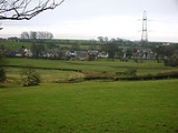
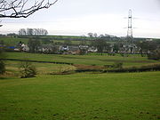
Gateside is a small village in North Ayrshire
, Scotland about half a mile east of Beith
on the B777.
Spier's school stood nearby and the grounds are now a public park used by the Gateside and Beith communities.
The Isabel Patrick Memorial Hall is a building in the Gothic style
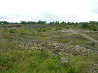
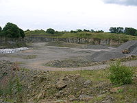
. Trearne House stood near Gateside, but it was demolished and the site is now a large worked out limestone quarry.
A field behind the primary school was given to the community by the Marshall family who were the village blacksmiths for many years.
The meaning of Powgree, Gateside's burn, is suggested as being 'Stream of the herd (of deer)'.
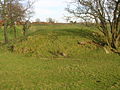 A Moot hill
or Court Hill survives near Gateside at Bog hall in the old Barony of Beith. Dobie states that the Abbot of Kilwinning used it to administered justice to his vassals & tenants. It is a sub-oval, flat-topped mound, situated at the foot of a small valley. A number of large stones are visible in the sides of the mound. It is turf-covered, situated on a low outcrop, and is mostly an artificial work. It pre-dates the channelling of the Boghall Burn which detours around it, the mound was probably isolated in this once marshy outflow of the former Boghall Loch (see NS35SE 14). Hill of Beith Castle
, a square tower castle, once held by the Cunninghame family, stood near to the moot hill.
or Bran was the name by which Boghall Loch was formerly known. The loch, drained in 1780, is one of the main sources of the Powgree Burn and lay on the lands of Boghall and Hill o'Beith. In the bottom of the loch piles or stakes of oak or elm have been found and it is thought that these may be the remains of crannog
s. The site is now represented by a low, marsh and reed covered area (less than 2 ha in extent) centred at NS 358 543 on the OS map.
The loch was once the property of the monks of Kilwinning Abbey
and it is recorded that in 1482 the monks took legal action against the Montgomeries of Giffin Castle
and James Ker who were accused of dangerous destruction and down-casting of the fosses and dikes of the loch called Loch Brand. It is not recorded what effect these actions had upon the size and depth of the loch.
the 'Weaver Poet'.
 The underlying geology of this part of Ayrshire is such that the presence of limestone quarries is to be expected. Lime kilns to produce quicklime for improving the soil, were a common feature of the countryside before the process became fully industrialised. Nettlehirst
near Barrmill was one of the last large traditionally operated lime kilns to operate, surviving until the 1970s, however Broadstone has the substantial remains of one of the largest of the early stone built kilns. This must have created considerable pollution in the area, offset only by the employment it created. It sits right next to the limestone quarry which supplied it. The road running past is still known as 'Reek Road'.
The possibly narrow gauge and single track 'Hillhead Railway', once ran from the Hillhead Limestone Quarries at Broadstone, down to the railway near Brackenhills railway station
on the old line from Giffen to the Glengarnock Steel Works, later the Lanarkshire and Ayrshire Railway
branchline to Kilbirnie South. The branchline to Beith via Barrmill did not exist at the time of the lines construction, not opening until 1873. A railway bridge was built to carry the Hillhead Railway over the new line and it must therefore have been fully active at that time.
 The Hillhead Railway is shown on the Ordnance Survey (OS) map of 1856, but not on the 1897 edition. The railway ran for several miles across what is now DM Beith land and ended up at first at an unloading point on a siding, where the limestone was emptied directly into standard gauge freight waggons. The map marks a few wooden railway bridges over burns and given the gentle gradients, it may be that the line was at first worked by horses rather than steam locomotives. Later maps show significant changes and record a 'Barkip Junction' and show the line now curving to meet was by then the Kilbirnie branchline.
Hillhead Quarry was part of the Broadstone Limestone Works and the original Broadstone Farm was entirely lost to the limestone workings. Hillhead Farm was renamed Broadstone; a farm that still exists. Little remains of the railway apart from a shallow cutting running down from near West Broadstone, the overbridge near the old South Windyhouse Farm on the Barrmill Road and the route running to the site of old Barkip Junction.
The old Ordnance Survey
maps show that a marble quarry was located nearby, being an especially hard form of limestone that could take a 'polish' and was used extensively for window and door surrounds.
are located in the woodlands and hills surrounding the village. The GPS co-ordinates of these caches can be found on the Geocaching website.
under its 'Crossreach' initiative. The name is pronounced 'Jillsland' locally. The origin of the name may refer to a gil or gyll, referring to a cleft or ravine as found at the 'Fairy Glen' where the Powgree Burn cuts through the fields.
Geilsland school
, run by the Church of Scotland
, is located nearby.
Image:Geilsland Lodge.JPG|Geilsland Lodge and main entrance
Image:Geilsland House 2.JPG|The side of the house which faces Geilsland Road and Speir's school grounds
Image:Geilsland House 4.JPG|The front of Geilsland House
showing later alterations
Image:Gielsland school Chapel.JPG|The chapel at Geilsland
North Ayrshire
North Ayrshire is one of 32 council areas in Scotland with a population of roughly 136,000 people. It is located in the south-west region of Scotland, and borders the areas of Inverclyde to the north, Renfrewshire to the north-east and East Ayrshire and South Ayrshire to the East and South...
, Scotland about half a mile east of Beith
Beith
Beith is a small town situated in the Garnock Valley in North Ayrshire, Scotland approximately 20-miles south-west of Glasgow. The town is situated on the crest of a hill and was known originally as the "Hill o' Beith" after its Court Hill.-History:-Name:Beith's name is thought to emanate from...
on the B777.
The village
Gateside Primary School, headteacher Ms Fiona Dunlop, was opened in 1903, and nowadays it has 74 pupils. The school has an extension built in 1998 which provided indoor toilets and a school hall, which is used by the nursery, PE classes and for school dinners and for assemblies. Another extension is to be built soon. The school is very environmentally aware and has achieved its Green Flag Award (2009).Spier's school stood nearby and the grounds are now a public park used by the Gateside and Beith communities.
The Isabel Patrick Memorial Hall is a building in the Gothic style
Gothic Revival architecture
The Gothic Revival is an architectural movement that began in the 1740s in England...
. Trearne House stood near Gateside, but it was demolished and the site is now a large worked out limestone quarry.
A field behind the primary school was given to the community by the Marshall family who were the village blacksmiths for many years.
The meaning of Powgree, Gateside's burn, is suggested as being 'Stream of the herd (of deer)'.
The Court Hill
Moot hill
A moot hill or mons placiti is a hill or mound historically used as an assembly or meeting place. In early medieval Britain, such hills were used for "moots", meetings of local people to settle local business. Among other things, proclamations might be read; decisions might be taken; court cases...
or Court Hill survives near Gateside at Bog hall in the old Barony of Beith. Dobie states that the Abbot of Kilwinning used it to administered justice to his vassals & tenants. It is a sub-oval, flat-topped mound, situated at the foot of a small valley. A number of large stones are visible in the sides of the mound. It is turf-covered, situated on a low outcrop, and is mostly an artificial work. It pre-dates the channelling of the Boghall Burn which detours around it, the mound was probably isolated in this once marshy outflow of the former Boghall Loch (see NS35SE 14). Hill of Beith Castle
Hill of Beith Castle
The old Barony and castle, fortalice, or tower house of Hill of Beith lay in the feudal Regality of Kilwinning, within the Baillerie of Cunninghame, and the Sherrifdom of Ayr, now the Parish of Beith, North Ayrshire, Scotland.-The Abbots of Kilwinning Abbey:...
, a square tower castle, once held by the Cunninghame family, stood near to the moot hill.
Boghall Loch
Loch BrandLoch Brand
Loch Brand or Loch of Boghall was situated in a depression between the Grange Estate, Crummock, Hill of Beith Castle site and Boghall in the Parish of Beith, East Ayrshire, Scotland. The loch was fed by the Grange Burn and surface runoff, such as from the old rig and furrows indicated by Roy's Maps...
or Bran was the name by which Boghall Loch was formerly known. The loch, drained in 1780, is one of the main sources of the Powgree Burn and lay on the lands of Boghall and Hill o'Beith. In the bottom of the loch piles or stakes of oak or elm have been found and it is thought that these may be the remains of crannog
Crannog
A crannog is typically a partially or entirely artificial island, usually built in lakes, rivers and estuarine waters of Scotland and Ireland. Crannogs were used as dwellings over five millennia from the European Neolithic Period, to as late as the 17th/early 18th century although in Scotland,...
s. The site is now represented by a low, marsh and reed covered area (less than 2 ha in extent) centred at NS 358 543 on the OS map.
The loch was once the property of the monks of Kilwinning Abbey
Kilwinning Abbey
Kilwinning Abbey is a ruined abbey located in the centre of the town of Kilwinning, North Ayrshire.-The establishment of the Abbey:The ancient name of the town is 'Segdoune' or 'Saigtown', probably derived from 'Sanctoun', meaning the 'town of the saint'. Saint Winnings festival was on 21 January...
and it is recorded that in 1482 the monks took legal action against the Montgomeries of Giffin Castle
Barony and Castle of Giffen
The Barony of Giffen and its associated 15th-century castle were in the parish of Beith in the former District of Cunninghame, now North Ayrshire. The site may be spelled Giffen or Giffin and lay within the Lordship of Giffin, which included the Baronies of Giffen, Trearne, Hessilhead, Broadstone,...
and James Ker who were accused of dangerous destruction and down-casting of the fosses and dikes of the loch called Loch Brand. It is not recorded what effect these actions had upon the size and depth of the loch.
Boghall Farm
This old habitation, marked as Boighall on a 1654 map was the home to the mother, Janet Pollock, of Robert TannahillRobert Tannahill
Robert Tannahill was a Scottish poet. Known as the 'Weaver Poet', his music and poetry is contemporaneous with that of Robert Burns.He was born at Castle Street in Paisley on 3 June 1774, the fourth son in a family of seven...
the 'Weaver Poet'.
Limestone and marble
Barony and Castle of Giffen
The Barony of Giffen and its associated 15th-century castle were in the parish of Beith in the former District of Cunninghame, now North Ayrshire. The site may be spelled Giffen or Giffin and lay within the Lordship of Giffin, which included the Baronies of Giffen, Trearne, Hessilhead, Broadstone,...
near Barrmill was one of the last large traditionally operated lime kilns to operate, surviving until the 1970s, however Broadstone has the substantial remains of one of the largest of the early stone built kilns. This must have created considerable pollution in the area, offset only by the employment it created. It sits right next to the limestone quarry which supplied it. The road running past is still known as 'Reek Road'.
The possibly narrow gauge and single track 'Hillhead Railway', once ran from the Hillhead Limestone Quarries at Broadstone, down to the railway near Brackenhills railway station
Brackenhills railway station
Brackenhills railway station was a railway station approximately one mile south-west of the town of Beith, North Ayrshire, Scotland, part of the Lanarkshire and Ayrshire Railway.- History :...
on the old line from Giffen to the Glengarnock Steel Works, later the Lanarkshire and Ayrshire Railway
Lanarkshire and Ayrshire Railway
The Lanarkshire and Ayrshire Railway was a railway company in Scotland built in the late 19th century that provided services between Ardrossan and Glasgow, with branches to Irvine and Kilbirnie. The line was operated by the Caledonian Railway with an aim to compete with the Glasgow and South...
branchline to Kilbirnie South. The branchline to Beith via Barrmill did not exist at the time of the lines construction, not opening until 1873. A railway bridge was built to carry the Hillhead Railway over the new line and it must therefore have been fully active at that time.
Hillhead Quarry was part of the Broadstone Limestone Works and the original Broadstone Farm was entirely lost to the limestone workings. Hillhead Farm was renamed Broadstone; a farm that still exists. Little remains of the railway apart from a shallow cutting running down from near West Broadstone, the overbridge near the old South Windyhouse Farm on the Barrmill Road and the route running to the site of old Barkip Junction.
The old Ordnance Survey
Ordnance Survey
Ordnance Survey , an executive agency and non-ministerial government department of the Government of the United Kingdom, is the national mapping agency for Great Britain, producing maps of Great Britain , and one of the world's largest producers of maps.The name reflects its creation together with...
maps show that a marble quarry was located nearby, being an especially hard form of limestone that could take a 'polish' and was used extensively for window and door surrounds.
Local Geocaches
Several geocachesGeocaching
Geocaching is an outdoor sporting activity in which the participants use a Global Positioning System receiver or mobile device and other navigational techniques to hide and seek containers, called "geocaches" or "caches", anywhere in the world....
are located in the woodlands and hills surrounding the village. The GPS co-ordinates of these caches can be found on the Geocaching website.
Geilsland House and School
Geilsland House is part of Geilsland school, run by the Church of ScotlandChurch of Scotland
The Church of Scotland, known informally by its Scots language name, the Kirk, is a Presbyterian church, decisively shaped by the Scottish Reformation....
under its 'Crossreach' initiative. The name is pronounced 'Jillsland' locally. The origin of the name may refer to a gil or gyll, referring to a cleft or ravine as found at the 'Fairy Glen' where the Powgree Burn cuts through the fields.
Geilsland school
Speir's school
Spier's school, at Beith, in North Ayrshire, Scotland, NS 35355327, KA15 1LU, was opened in 1888 and closed in 1972. The school, now demolished, was built using Ballochmyle red sandstone and was reminiscent of the ancient Glasgow University. The school motto was 'Quod verum tutum'...
, run by the Church of Scotland
Church of Scotland
The Church of Scotland, known informally by its Scots language name, the Kirk, is a Presbyterian church, decisively shaped by the Scottish Reformation....
, is located nearby.
Image:Geilsland Lodge.JPG|Geilsland Lodge and main entrance
Image:Geilsland House 2.JPG|The side of the house which faces Geilsland Road and Speir's school grounds
Image:Geilsland House 4.JPG|The front of Geilsland House
Geilsland House
Geilsland House lies in between the village of Gateside and the town of Beith in North Ayrshire, Scotland.- Geilsland House:Geilsland was a half merk land, part of the 4 merk land of Marshalland, in the Barony of Braidstone. An earlier name is said to have been 'Neilsland'. The name is pronounced...
showing later alterations
Image:Gielsland school Chapel.JPG|The chapel at Geilsland
See also
- Hill of Beith CastleHill of Beith CastleThe old Barony and castle, fortalice, or tower house of Hill of Beith lay in the feudal Regality of Kilwinning, within the Baillerie of Cunninghame, and the Sherrifdom of Ayr, now the Parish of Beith, North Ayrshire, Scotland.-The Abbots of Kilwinning Abbey:...
- HessilheadHessilheadHessilhead is in Beith, North Ayrshire, Scotland. Hessilhead used to be called Hazlehead or Hasslehead. The lands were part of the Lordship of Giffen, and the Barony of Hessilhead, within the Baillerie of Cunninghame and the Parish of Beith...
- Barony and Castle of GiffenBarony and Castle of GiffenThe Barony of Giffen and its associated 15th-century castle were in the parish of Beith in the former District of Cunninghame, now North Ayrshire. The site may be spelled Giffen or Giffin and lay within the Lordship of Giffin, which included the Baronies of Giffen, Trearne, Hessilhead, Broadstone,...
- BarrmillBarrmillBarrmill is a small village in North Ayrshire, Scotland about a mile and a half a mile east of Beith on the road to Lugton. Locally it is known as the Barr.- History :General Roy's survey of 1747 - 55 shows only the farm of High Barr...
- Barony of LadylandBarony of LadylandThe Barony of Ladyland was in the old feudal Baillerie of Cunninghame, near Kilbirnie in what is now North Ayrshire, Scotland.- The history of the Barony of Ladyland :...
- Broadstone, North AyrshireBroadstone, North AyrshireBroadstone lies close to the small village of Gateside in North Ayrshire, Scotland about half a mile east of Beith in the old Barony of Giffen.-The castle:The ruins of Braidstone or Broadstone Castle remained until about 1850...