
Gatehead, East Ayrshire
Encyclopedia
The village or hamlet of Gatehead is located in East Ayrshire
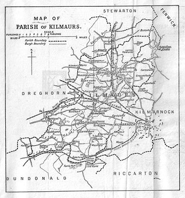
, Parish
of Kilmaurs
, Scotland
. It is one and a quarter miles from Crosshouse and one and a half miles from Kilmarnock
. In the 18th and 19th centuries the locality was a busy coal mining district. The settlement is on the banks of the River Irvine.
or Crosshouse
via Craig and yet another to Crosshouse, branching off the main Kilmarnock road. The settlement no doubt developed to cater for travellers on these roads and from the railway which was used also by carts and pedestrians as a 'toll' road or tramway
prior to 1846. The local shop and post office next to the old station closed within the last ten years (1985 OS). The river forms the boundary with South Ayrshire
, previously 'Kyle and Carrick', Parish of Dundonald
.
 Gatehead is most likely to have been named after the Turnpike road and the toll bar or gate. A 'Gatehead Toll Bar' is still marked nearby on the to Laigh Milton mill and the Craig House estate as late as 1860 on the Ordnance Survey
(OS) map of that year. 'Gatehead' is apparently first recorded marked on General Roy's Military Survey map of Scotland (1745–55) and then by Armstrong's 1775 map. The RCAHMS website records the site of a Toll house at NS 3898 3670.
Archibald Adamson records a walk through Gatehead in 1875. He mentions a neat lodge house at Fairlie, then owned by a Captain Tait and records that the Irvine bridge has recently replaced an older one. The Old Rome miners cottages are in ruins following the local coal pits being worked out and the distillery ruins are still apparent. He goes on to say that Gatehead was established around fifty years back, i.e. circa 1825, and has neither kirk, smithy, mill or market, but it does have a station.
Laigh Milton viaduct
over the River Irvine
stands nearby. This is the oldest railway viaduct in Scotland, and one of the oldest in the world.
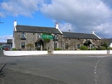
The Cochrane Inn is likely to have originally been a coaching inn, serving the stagecoach route from Kilmarnock
to Troon
and Ayr
. A milestone near the Crosshouse
junction on the main road in 1860 gave Troon as 7 miles and Dundonald
as 2 1/4 miles and another near the junction for Laigh Milton Mill gave Ayr as 10 miles and Kilmarnock as 2 1/4 miles.
A hamlet called 'Milton' is marked on the 1821 and 1828 maps, but the name is not marked on the 1860 and the more recent OS maps. Laigh Milton mill still stands, but is now in a ruinous condition (2007). A laithe or saw mill existed across the river from Craig House, which had its own mill and a ford, together with another mill near Drybridge at 'Girtrig' or previously 'Greatrig'.
Old Rome coal pit, just across the river is mentioned in the novel 'A tree in the West' by Anna Blair, and relates an incident where a young boy is so terrified of being sent down to work in the mine that he runs away instead. A 'Romford', 'Rameford', 'Room' or 'Rome Ford' was situated where the modern road bridge crossing the River Irvine
is located. In Scots 'Rommle' is to rumble or stir violently, a more likely explanation than some memory of the Roman occupation of Scotland. Another suggestion is that 'Room' or 'Rome' in Scots meant a small farm. Both Thomson and Ainslie show the railway apparently branching and crossing the Irvine by means of a bridge near to the ford and this branch or mineral line halting near Fairlie House on Thomson's map and carrying on towards Symington on Ainslie's map. This branch may never have been built, shown due to its planned, but not executed, construction.
The railway level crossing
has been here since the Kilmarnock and Troon Railway
opened in 1811, but as stated, the name 'Gatehead' predates the railway. A stable was located hereabouts and the horses pulling the wagons were changed here. Gatehead railway station
closed in 1967, having opened with the rest of the line on 6 July 1812. The 1860 OS map shows a milepost indicating Kilmarnock at 2 3/4 miles and Troon at 7 1/4 miles.
A distillery once existed near Old Rome, although no signs of its existence are now visible.
A smithy existed, as marked on the 1880s OS. It was on the left-hand side, just across the bridge from Old Rome.
and Carmel Bank (previously known as Mote or Moit in 1604), previously another Cunninghame property lies near Springside
. Craig House was at one point sold to Glasgow Corporation as a 'respite home' for mainly Glaswegian children, it became a ruin after the 'school' closed, however it has since been fully restored and converted into flats. Fairlie was locally termed "Fairlie o' the five lums" according to Adamson in 1875, on account of the five large chimneys in a row along the roof ridge of the mansion. Fairlie had been known as 'Little Dreghorn', until William Fairlie of Bruntsfield gave it his family name in around 1704. Robert Gordon's manuscript map of ca. 1636 - 52 indicates a small mansion at 'Little Drogarn', and it has been suggested by McNaught that the woodland here was locally known as 'Old Rome Forest' at this time. The 'Laird of Fairlie' also owned Arrothill. Sir William Cunninghame of Fairlie and Robertland is recorded by George Robertson in 1823 as living "in a shewy modern mansion", i.e. Fairlie. A mineral spring known as 'Spiers Well' existed near Gatehead in 1789.
, Craig, Woodhills, Greenhill, Altonhill, Plann, Hayside, Thorntoun, Rash-hill Park, Milton, Windyedge, Fardelhill, Muirfields, Corsehouse and Knockentiber and Busbie.
' father worked on the Fairlie Estate as a gardener for a time. Old Rome Forest or Old Room Ford was a house where Jean Brown, an aunt of Burns on his mother's side, lived with her husband, James Allan. When Burns had to go into hiding as a result of James Armour's warrant for his arrest, the poet stayed at his aunt's house. Nothing remains of Old Rome Forest, but according to Duncan M'Naught, the Kilmaurs
schoolmaster and local historian, (in an article in the Burns Chronicle, 1893) the house was on the Fairlie estate. McNaught states that Fairlie House was called 'Old Rome Forest' in his day. In "Poor Maillie's Elergy" Burns introduced the "famous breed" of Fairlie lambs.
On the 1923 OS mineral lines still run to collieries near Earlston, Nether Craig and Cockhill farm (Fairlie (Pit No.3)). Earlston has a sawmill marked as well. The 1860 OS names the 'Fairlie Branch' and indicates its operation by the Glasgow and South Western Railway
company. The bridges built for these lines are still clearly visible with the exception of the wooden bridge crossing the river near the original stone viaduct. The latter either being demolished or succoming to the elements when the main line was moved to its current position. The 1895 OS shows a colliery at Templeton near Earlston and another mineral line running up to a colliery at Bogside near Ellerslie in Kilmarnock. A coal pit is marked at Old Rome in 1860, with miners rows and a school. The school building survives as a private house, being the last building (2007) on the left before the junction for Symington. Another coalpit was located near a smithy opposite Peatland House. John Finnie of 'Kilmarnock fame' enlarged Peatland House for his sisters.
claimed many lives in Kilmaurs
and to prevent the entrance of strangers or vagrants, guards were placed at Gatehead, Knockentiber
and other places to prevent any communication between the occupants of Kilmaurs and the rest of the community.
East Ayrshire
East Ayrshire is one of 32 council areas of Scotland. It borders on to North Ayrshire, East Renfrewshire, South Lanarkshire, South Ayrshire and Dumfries and Galloway...
, Parish
Parish
A parish is a territorial unit historically under the pastoral care and clerical jurisdiction of one parish priest, who might be assisted in his pastoral duties by a curate or curates - also priests but not the parish priest - from a more or less central parish church with its associated organization...
of Kilmaurs
Kilmaurs
Kilmaurs is a village in East Ayrshire, Scotland. It lies on the Carmel, 21.1 miles south by west of Glasgow. Population recorded in 2001 Census, 2601- History :...
, Scotland
Scotland
Scotland is a country that is part of the United Kingdom. Occupying the northern third of the island of Great Britain, it shares a border with England to the south and is bounded by the North Sea to the east, the Atlantic Ocean to the north and west, and the North Channel and Irish Sea to the...
. It is one and a quarter miles from Crosshouse and one and a half miles from Kilmarnock
Kilmarnock
Kilmarnock is a large burgh in East Ayrshire, Scotland, with a population of 44,734. It is the second largest town in Ayrshire. The River Irvine runs through its eastern section, and the Kilmarnock Water passes through it, giving rise to the name 'Bank Street'...
. In the 18th and 19th centuries the locality was a busy coal mining district. The settlement is on the banks of the River Irvine.
Introduction
Gatehead, an old colliers' village,Groome, Francis H. (1903). Ordnance Gazetteer of Scotland. Pub. Caxton. London. P. 643. lies at or near the junction of several roads, namely the main road to Kilmarnock, Dundonald & Troon , a road to Symington or Kilmarnock via Earlston, another to Springside, East AyrshireSpringside, Ayrshire
The village of Springside is in North Ayrshire, Parish of Dreghorn, Scotland. It is three miles from Irvine, 1½ miles west of Crosshouse and four miles from Kilmarnock. In the 18th, 19th and mid 20th centuries the locality was a highly industrialised coal mining district. The settlement is on the...
or Crosshouse
Crosshouse
Crosshouse is a village located in East Ayrshire just outside Kilmarnock.The village even has its own hospital Crosshouse Hospital the hospital was built to replace the Kilmarnock Infirmary....
via Craig and yet another to Crosshouse, branching off the main Kilmarnock road. The settlement no doubt developed to cater for travellers on these roads and from the railway which was used also by carts and pedestrians as a 'toll' road or tramway
Laigh Milton Viaduct
Laigh Milton Viaduct is a railway viaduct near Laigh Milton mill at Gatehead in East Ayrshire, Scotland. It lies in the parishes of Kilmaurs and Dundonald, at map reference: NS 3834 3690. The viaduct was closed in 1846 when the railway line was realigned.- Laigh Milton viaduct :The stone viaduct...
prior to 1846. The local shop and post office next to the old station closed within the last ten years (1985 OS). The river forms the boundary with South Ayrshire
South Ayrshire
South Ayrshire is one of 32 council areas of Scotland, covering the southern part of Ayrshire. It borders onto East Ayrshire, North Ayrshire and Dumfries and Galloway....
, previously 'Kyle and Carrick', Parish of Dundonald
Dundonald
Dundonald is a large settlement in County Down, Northern Ireland. It lies east of Belfast and is often deemed to be a suburb of the city. It includes the large housing estate of Ballybeen, and many new housing estates have emerged in the past ten years....
.
History
Ordnance Survey
Ordnance Survey , an executive agency and non-ministerial government department of the Government of the United Kingdom, is the national mapping agency for Great Britain, producing maps of Great Britain , and one of the world's largest producers of maps.The name reflects its creation together with...
(OS) map of that year. 'Gatehead' is apparently first recorded marked on General Roy's Military Survey map of Scotland (1745–55) and then by Armstrong's 1775 map. The RCAHMS website records the site of a Toll house at NS 3898 3670.
Archibald Adamson records a walk through Gatehead in 1875. He mentions a neat lodge house at Fairlie, then owned by a Captain Tait and records that the Irvine bridge has recently replaced an older one. The Old Rome miners cottages are in ruins following the local coal pits being worked out and the distillery ruins are still apparent. He goes on to say that Gatehead was established around fifty years back, i.e. circa 1825, and has neither kirk, smithy, mill or market, but it does have a station.
Laigh Milton viaduct
Laigh Milton Viaduct
Laigh Milton Viaduct is a railway viaduct near Laigh Milton mill at Gatehead in East Ayrshire, Scotland. It lies in the parishes of Kilmaurs and Dundonald, at map reference: NS 3834 3690. The viaduct was closed in 1846 when the railway line was realigned.- Laigh Milton viaduct :The stone viaduct...
over the River Irvine
River Irvine
The River Irvine is a river flowing through southwest Scotland, with its watershed on the Lanarkshire border of Ayrshire at an altitude of above sea-level, near Drumclog, and SW by W of Strathaven...
stands nearby. This is the oldest railway viaduct in Scotland, and one of the oldest in the world.
The Cochrane Inn is likely to have originally been a coaching inn, serving the stagecoach route from Kilmarnock
Kilmarnock
Kilmarnock is a large burgh in East Ayrshire, Scotland, with a population of 44,734. It is the second largest town in Ayrshire. The River Irvine runs through its eastern section, and the Kilmarnock Water passes through it, giving rise to the name 'Bank Street'...
to Troon
Troon
Troon is a town in South Ayrshire. It is situated on the west coast of Scotland, about eight miles north of Ayr and three miles northwest of Glasgow Prestwick International Airport. Lying across the Firth of Clyde, the Isle of Arran can be seen. Troon is also a port with freight and ferry services...
and Ayr
Ayr
Ayr is a town and port situated on the Firth of Clyde in south-west Scotland. With a population of around 46,000, Ayr is the largest settlement in Ayrshire, of which it is the county town, and has held royal burgh status since 1205...
. A milestone near the Crosshouse
Crosshouse
Crosshouse is a village located in East Ayrshire just outside Kilmarnock.The village even has its own hospital Crosshouse Hospital the hospital was built to replace the Kilmarnock Infirmary....
junction on the main road in 1860 gave Troon as 7 miles and Dundonald
Dundonald
Dundonald is a large settlement in County Down, Northern Ireland. It lies east of Belfast and is often deemed to be a suburb of the city. It includes the large housing estate of Ballybeen, and many new housing estates have emerged in the past ten years....
as 2 1/4 miles and another near the junction for Laigh Milton Mill gave Ayr as 10 miles and Kilmarnock as 2 1/4 miles.
A hamlet called 'Milton' is marked on the 1821 and 1828 maps, but the name is not marked on the 1860 and the more recent OS maps. Laigh Milton mill still stands, but is now in a ruinous condition (2007). A laithe or saw mill existed across the river from Craig House, which had its own mill and a ford, together with another mill near Drybridge at 'Girtrig' or previously 'Greatrig'.
Old Rome coal pit, just across the river is mentioned in the novel 'A tree in the West' by Anna Blair, and relates an incident where a young boy is so terrified of being sent down to work in the mine that he runs away instead. A 'Romford', 'Rameford', 'Room' or 'Rome Ford' was situated where the modern road bridge crossing the River Irvine
River Irvine
The River Irvine is a river flowing through southwest Scotland, with its watershed on the Lanarkshire border of Ayrshire at an altitude of above sea-level, near Drumclog, and SW by W of Strathaven...
is located. In Scots 'Rommle' is to rumble or stir violently, a more likely explanation than some memory of the Roman occupation of Scotland. Another suggestion is that 'Room' or 'Rome' in Scots meant a small farm. Both Thomson and Ainslie show the railway apparently branching and crossing the Irvine by means of a bridge near to the ford and this branch or mineral line halting near Fairlie House on Thomson's map and carrying on towards Symington on Ainslie's map. This branch may never have been built, shown due to its planned, but not executed, construction.
The railway level crossing
Level crossing
A level crossing occurs where a railway line is intersected by a road or path onone level, without recourse to a bridge or tunnel. It is a type of at-grade intersection. The term also applies when a light rail line with separate right-of-way or reserved track crosses a road in the same fashion...
has been here since the Kilmarnock and Troon Railway
Kilmarnock and Troon Railway
The Kilmarnock and Troon Railway was the first railway line in Scotland authorised by Act of Parliament, in 1808; the engineer was William Jessop. It was the first railway in Scotland to use a steam locomotive; and it was the only one in Scotland for fourteen years...
opened in 1811, but as stated, the name 'Gatehead' predates the railway. A stable was located hereabouts and the horses pulling the wagons were changed here. Gatehead railway station
Gatehead railway station
Gatehead railway station was a railway station serving the village of Gatehead, East Ayrshire, Scotland.- History :The station was opened on 6 July 1812 by the Kilmarnock and Troon Railway...
closed in 1967, having opened with the rest of the line on 6 July 1812. The 1860 OS map shows a milepost indicating Kilmarnock at 2 3/4 miles and Troon at 7 1/4 miles.
A distillery once existed near Old Rome, although no signs of its existence are now visible.
A smithy existed, as marked on the 1880s OS. It was on the left-hand side, just across the bridge from Old Rome.
Estates
Gatehead was surrounded by several country estates which provided employment and helped create the need for the establishment of settlements such as Gatehead. The Craig estate of the Dunlops and more recently the Pollok-Morris's, lying within the ancient Barony of Robertoun, lay just beyond Laigh Milton Mill and the Fairlie estate is just across the River Irvine. Capringtoun, a Cunninghame clan estate is nearby and ThorntounThorntoun house and estate
Thorntoun School was opened by Barnardo's in September 1971 for children with emotional difficulties aged 11 to 16 years. The school closed in 1990 and Thorntoun is now a Nursing Home. The complex lies between the villages of Springside and Crosshouse, Kilmarnock in East Ayrshire, Scotland...
and Carmel Bank (previously known as Mote or Moit in 1604), previously another Cunninghame property lies near Springside
Springside
Springside may refer to:*Springside, Ayrshire, a village in Scotland*Springside , estate of Matthew Vassar with landscaped grounds in Poughkeepsie, New York, U.S.A....
. Craig House was at one point sold to Glasgow Corporation as a 'respite home' for mainly Glaswegian children, it became a ruin after the 'school' closed, however it has since been fully restored and converted into flats. Fairlie was locally termed "Fairlie o' the five lums" according to Adamson in 1875, on account of the five large chimneys in a row along the roof ridge of the mansion. Fairlie had been known as 'Little Dreghorn', until William Fairlie of Bruntsfield gave it his family name in around 1704. Robert Gordon's manuscript map of ca. 1636 - 52 indicates a small mansion at 'Little Drogarn', and it has been suggested by McNaught that the woodland here was locally known as 'Old Rome Forest' at this time. The 'Laird of Fairlie' also owned Arrothill. Sir William Cunninghame of Fairlie and Robertland is recorded by George Robertson in 1823 as living "in a shewy modern mansion", i.e. Fairlie. A mineral spring known as 'Spiers Well' existed near Gatehead in 1789.
The Barony of Robertoun
This barony, once part of the Barony of Kilmaurs, ran from Kilmaurs south to the river Irvine. It had no manor house and belonged to the Eglinton family latterly. The following properties were part of the barony: Gatehead, parts of KilmaursKilmaurs
Kilmaurs is a village in East Ayrshire, Scotland. It lies on the Carmel, 21.1 miles south by west of Glasgow. Population recorded in 2001 Census, 2601- History :...
, Craig, Woodhills, Greenhill, Altonhill, Plann, Hayside, Thorntoun, Rash-hill Park, Milton, Windyedge, Fardelhill, Muirfields, Corsehouse and Knockentiber and Busbie.
Robert Burns
Robert BurnsRobert Burns
Robert Burns was a Scottish poet and a lyricist. He is widely regarded as the national poet of Scotland, and is celebrated worldwide...
' father worked on the Fairlie Estate as a gardener for a time. Old Rome Forest or Old Room Ford was a house where Jean Brown, an aunt of Burns on his mother's side, lived with her husband, James Allan. When Burns had to go into hiding as a result of James Armour's warrant for his arrest, the poet stayed at his aunt's house. Nothing remains of Old Rome Forest, but according to Duncan M'Naught, the Kilmaurs
Kilmaurs
Kilmaurs is a village in East Ayrshire, Scotland. It lies on the Carmel, 21.1 miles south by west of Glasgow. Population recorded in 2001 Census, 2601- History :...
schoolmaster and local historian, (in an article in the Burns Chronicle, 1893) the house was on the Fairlie estate. McNaught states that Fairlie House was called 'Old Rome Forest' in his day. In "Poor Maillie's Elergy" Burns introduced the "famous breed" of Fairlie lambs.
Collieries and Coal Pits
A branch of rail way (sic) ran in from the Kilmarnock and Troon 'main line' near Gateside to coal works belonging to Sir William Cuninghame of Robertland Bart. The length of the branch was four furlongs and one hundred and seven yards nearly. The line crossed the river downstream of the Romeford bridge.On the 1923 OS mineral lines still run to collieries near Earlston, Nether Craig and Cockhill farm (Fairlie (Pit No.3)). Earlston has a sawmill marked as well. The 1860 OS names the 'Fairlie Branch' and indicates its operation by the Glasgow and South Western Railway
Glasgow and South Western Railway
The Glasgow and South Western Railway , one of the pre-grouping railway companies, served a triangular area of south-west Scotland, between Glasgow, Stranraer and Carlisle...
company. The bridges built for these lines are still clearly visible with the exception of the wooden bridge crossing the river near the original stone viaduct. The latter either being demolished or succoming to the elements when the main line was moved to its current position. The 1895 OS shows a colliery at Templeton near Earlston and another mineral line running up to a colliery at Bogside near Ellerslie in Kilmarnock. A coal pit is marked at Old Rome in 1860, with miners rows and a school. The school building survives as a private house, being the last building (2007) on the left before the junction for Symington. Another coalpit was located near a smithy opposite Peatland House. John Finnie of 'Kilmarnock fame' enlarged Peatland House for his sisters.
Farms
West and East Gatehead Farms are close by, New Bogside is on the direct Crosshouse road, whilst Arrathill (1860 OS) or Arrothill (1985 OS) farm lies across the river towards Earlston. An Arrathill Mount overlooks Old Rome. In 1829 the Kilmarnock & Troon Railway agreed to pay compensation to the Earl of Eglinton of £185.13s.10d for damage to East & West Gatehead Farms and land used.)Cholera
In 1832 an outbreak of CholeraCholera
Cholera is an infection of the small intestine that is caused by the bacterium Vibrio cholerae. The main symptoms are profuse watery diarrhea and vomiting. Transmission occurs primarily by drinking or eating water or food that has been contaminated by the diarrhea of an infected person or the feces...
claimed many lives in Kilmaurs
Kilmaurs
Kilmaurs is a village in East Ayrshire, Scotland. It lies on the Carmel, 21.1 miles south by west of Glasgow. Population recorded in 2001 Census, 2601- History :...
and to prevent the entrance of strangers or vagrants, guards were placed at Gatehead, Knockentiber
Knockentiber
Knockentiber is a village in East Ayrshire, Parish of Kilmaurs, Scotland. Knockentiber is WNW of Kilmarnock and 1/2 mile NE of Crosshouse. Latitude:55.6193°N Longitude:4.5455°W and . The population was 359 in 1991, however the population is much higher following the construction of several...
and other places to prevent any communication between the occupants of Kilmaurs and the rest of the community.
Scrappy
There was a scrap metal yard in the village which was located on the main road just south of the existing railway . This site could have possibly been sidings of the rail network and railway station which was on the north side of the railway . The site, which was surrouded by a mesh fence on the south village side and a sandstone wall on the main road and railway sides had a large Sandstone building was located within it . When the Yard was closed the land was used to build houses on .A Map of the Parish of Kilmaurs