

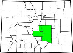
South Central Colorado Urban Area
Encyclopedia
Colorado Springs Metropolitan Statistical Area
The Colorado Springs Metropolitan Statistical Area is a United States Census Bureau defined Metropolitan Statistical Area located in the Colorado Springs region of the State of Colorado. The Census Bureau estimates that the population was 647,758 in 2010, a 20.48% increase since 2000. The...
, the Pueblo Metropolitan Statistical Area, and the Cañon City Micropolitan Statistical Area
Cañon City Micropolitan Statistical Area
The Cañon City Micropolitan Statistical Area is a United States Census Bureau defined Micropolitan Statistical Area located in the Cañon City area of the State of Colorado. The Cañon City Micropolitan Statistical Area is defined as Fremont County, Colorado. The Micropolitan Statistical Area had a...
in the central and south central region of the State of Colorado
Colorado
Colorado is a U.S. state that encompasses much of the Rocky Mountains as well as the northeastern portion of the Colorado Plateau and the western edge of the Great Plains...
. With the exception of northern Teller County
Teller County, Colorado
Teller County is the 22nd most populous of the 64 counties of the State of Colorado of the United States. The county population was 20,555 at U.S. Census 2000. The county seat is Cripple Creek, and the most populous city is Woodland Park...
and small portions of northern El Paso County
El Paso County, Colorado
El Paso County is the most populous of the 64 counties of the state of Colorado of the United States, now more populous than Denver County. The United States Census Bureau concluded that the county population was 622,371 in 2010. In recent years, the population had come closer to that of Denver...
, the entire South Central Colorado Urban Area is drained by the Arkansas River
Arkansas River
The Arkansas River is a major tributary of the Mississippi River. The Arkansas generally flows to the east and southeast as it traverses the U.S. states of Colorado, Kansas, Oklahoma, and Arkansas. The river's initial basin starts in the Western United States in Colorado, specifically the Arkansas...
and its tributaries. The South Central Colorado Urban Area is the southernmost of the three primary subregions of the Front Range Urban Corridor
Front Range Urban Corridor
The Front Range Urban Corridor is an oblong region of urban population located along the eastern face of the Southern Rocky Mountains in the U.S. states of Colorado and Wyoming. The corridor derives its name from the Front Range, the mountain range that defines the west central boundary of the...
.
The South Central Colorado Urban Area had a population of 851,500 at the 2010 United States Census, and increase of 17.43% from the 2000 United States Census. In 2010, 16.93% of Coloradans lived in the South Central Colorado Urban Area.
Extent
| Core Based Statistical Area | 2010 Census | County | 2010 Census | 2000 Census | Pop Change |
|---|---|---|---|---|---|
| Colorado Springs, CO MSA | 645,613 | El Paso County, Colorado El Paso County, Colorado El Paso County is the most populous of the 64 counties of the state of Colorado of the United States, now more populous than Denver County. The United States Census Bureau concluded that the county population was 622,371 in 2010. In recent years, the population had come closer to that of Denver... |
|||
| Teller County, Colorado Teller County, Colorado Teller County is the 22nd most populous of the 64 counties of the State of Colorado of the United States. The county population was 20,555 at U.S. Census 2000. The county seat is Cripple Creek, and the most populous city is Woodland Park... |
|||||
| Pueblo, CO MSA | 159,063 | Pueblo County, Colorado Pueblo County, Colorado Pueblo County is the tenth most populous of the 64 counties of the state of Colorado of the United States. The county was named for the historic city of Pueblo which took its name from the Spanish language word meaning "town" or "village". The United States Census Bureau estimates that the... |
|||
| Cañon City, CO μSA | 46,824 | Fremont County, Colorado Fremont County, Colorado Fremont County is the thirteenth most populous of the 64 counties of the state of Colorado of the United States. The county is named for explorer and presidential candidate John C. Frémont. The county population was 46,824 at the 2010 census. The county seat is Cañon City. The Cañon City... |
|||
|-
|}
Municipalities
| Rank | Municipality | County | CBSA | 2010 Population |
|---|---|---|---|---|
| 1 | City of Colorado Springs Colorado Springs, Colorado Colorado Springs is a Home Rule Municipality that is the county seat and most populous city of El Paso County, Colorado, United States. Colorado Springs is located in South-Central Colorado, in the southern portion of the state. It is situated on Fountain Creek and is located south of the Colorado... |
El Paso County El Paso County, Colorado El Paso County is the most populous of the 64 counties of the state of Colorado of the United States, now more populous than Denver County. The United States Census Bureau concluded that the county population was 622,371 in 2010. In recent years, the population had come closer to that of Denver... |
Colorado Springs MSA | 416,427 |
| 2 | City of Pueblo Pueblo, Colorado Pueblo is a Home Rule Municipality that is the county seat and the most populous city of Pueblo County, Colorado, United States. The population was 106,595 in 2010 census, making it the 246th most populous city in the United States.... |
Pueblo County Pueblo County, Colorado Pueblo County is the tenth most populous of the 64 counties of the state of Colorado of the United States. The county was named for the historic city of Pueblo which took its name from the Spanish language word meaning "town" or "village". The United States Census Bureau estimates that the... |
Pueblo MSA | 106,595 |
| 3 | City of Fountain Fountain A fountain is a piece of architecture which pours water into a basin or jets it into the air either to supply drinking water or for decorative or dramatic effect.... |
El Paso County El Paso County, Colorado El Paso County is the most populous of the 64 counties of the state of Colorado of the United States, now more populous than Denver County. The United States Census Bureau concluded that the county population was 622,371 in 2010. In recent years, the population had come closer to that of Denver... |
Colorado Springs MSA | 25,846 |
| 4 | City of Cañon City | Fremont County Fremont County, Colorado Fremont County is the thirteenth most populous of the 64 counties of the state of Colorado of the United States. The county is named for explorer and presidential candidate John C. Frémont. The county population was 46,824 at the 2010 census. The county seat is Cañon City. The Cañon City... |
Cañon City μSA Cañon City Micropolitan Statistical Area The Cañon City Micropolitan Statistical Area is a United States Census Bureau defined Micropolitan Statistical Area located in the Cañon City area of the State of Colorado. The Cañon City Micropolitan Statistical Area is defined as Fremont County, Colorado. The Micropolitan Statistical Area had a... |
16,400 |
| 5 | City of Woodland Park Woodland Park, Colorado The City of Woodland Park is a Home Rule Municipality that is the most populous city in Teller County, Colorado, United States and is immediately west of El Paso County and the unincorporated community of Crystola. Many residents in this bedroom community, which is surrounded by the one-million... |
Teller County Teller County, Colorado Teller County is the 22nd most populous of the 64 counties of the State of Colorado of the United States. The county population was 20,555 at U.S. Census 2000. The county seat is Cripple Creek, and the most populous city is Woodland Park... |
Colorado Springs MSA | 7,200 |
| 6 | Town of Monument Monument A monument is a type of structure either explicitly created to commemorate a person or important event or which has become important to a social group as a part of their remembrance of historic times or cultural heritage, or simply as an example of historic architecture... |
El Paso County El Paso County, Colorado El Paso County is the most populous of the 64 counties of the state of Colorado of the United States, now more populous than Denver County. The United States Census Bureau concluded that the county population was 622,371 in 2010. In recent years, the population had come closer to that of Denver... |
Colorado Springs MSA | 5,530 |
| 7 | City of Manitou Springs | El Paso County El Paso County, Colorado El Paso County is the most populous of the 64 counties of the state of Colorado of the United States, now more populous than Denver County. The United States Census Bureau concluded that the county population was 622,371 in 2010. In recent years, the population had come closer to that of Denver... |
Colorado Springs MSA | 4,992 |
| 8 | City of Florence Florence Florence is the capital city of the Italian region of Tuscany and of the province of Florence. It is the most populous city in Tuscany, with approximately 370,000 inhabitants, expanding to over 1.5 million in the metropolitan area.... |
Fremont County Fremont County, Colorado Fremont County is the thirteenth most populous of the 64 counties of the state of Colorado of the United States. The county is named for explorer and presidential candidate John C. Frémont. The county population was 46,824 at the 2010 census. The county seat is Cañon City. The Cañon City... |
Cañon City μSA Cañon City Micropolitan Statistical Area The Cañon City Micropolitan Statistical Area is a United States Census Bureau defined Micropolitan Statistical Area located in the Cañon City area of the State of Colorado. The Cañon City Micropolitan Statistical Area is defined as Fremont County, Colorado. The Micropolitan Statistical Area had a... |
3,881 |
| 9 | Town of Palmer Lake | El Paso County El Paso County, Colorado El Paso County is the most populous of the 64 counties of the state of Colorado of the United States, now more populous than Denver County. The United States Census Bureau concluded that the county population was 622,371 in 2010. In recent years, the population had come closer to that of Denver... |
Colorado Springs MSA | 2,240 |
| 10 | City of Cripple Creek Cripple Creek, Colorado The City of Cripple Creek is a Statutory City that is the county seat of Teller County, Colorado, United States. Cripple Creek is a former gold mining camp located southwest of Colorado Springs near the base of Pikes Peak. The Cripple Creek Historic District, which received National Historic... |
Teller County Teller County, Colorado Teller County is the 22nd most populous of the 64 counties of the State of Colorado of the United States. The county population was 20,555 at U.S. Census 2000. The county seat is Cripple Creek, and the most populous city is Woodland Park... |
Colorado Springs MSA | 1,189 |
| 11 | Town of Calhan | El Paso County El Paso County, Colorado El Paso County is the most populous of the 64 counties of the state of Colorado of the United States, now more populous than Denver County. The United States Census Bureau concluded that the county population was 622,371 in 2010. In recent years, the population had come closer to that of Denver... |
Colorado Springs MSA | 780 |
| 12 | Town of Green Mountain Falls | El Paso County El Paso County, Colorado El Paso County is the most populous of the 64 counties of the state of Colorado of the United States, now more populous than Denver County. The United States Census Bureau concluded that the county population was 622,371 in 2010. In recent years, the population had come closer to that of Denver... Teller County Teller County, Colorado Teller County is the 22nd most populous of the 64 counties of the State of Colorado of the United States. The county population was 20,555 at U.S. Census 2000. The county seat is Cripple Creek, and the most populous city is Woodland Park... |
Colorado Springs MSA | 773 |
| 13 | Town of Williamsburg Williamsburg, Colorado The Town of Williamsburg is a Statutory Town located in Fremont County, Colorado, United States. The town population was 714 at the U.S. Census 2000... |
Fremont County Fremont County, Colorado Fremont County is the thirteenth most populous of the 64 counties of the state of Colorado of the United States. The county is named for explorer and presidential candidate John C. Frémont. The county population was 46,824 at the 2010 census. The county seat is Cañon City. The Cañon City... |
Cañon City μSA Cañon City Micropolitan Statistical Area The Cañon City Micropolitan Statistical Area is a United States Census Bureau defined Micropolitan Statistical Area located in the Cañon City area of the State of Colorado. The Cañon City Micropolitan Statistical Area is defined as Fremont County, Colorado. The Micropolitan Statistical Area had a... |
662 |
| 14 | Town of Rockvale | Fremont County Fremont County, Colorado Fremont County is the thirteenth most populous of the 64 counties of the state of Colorado of the United States. The county is named for explorer and presidential candidate John C. Frémont. The county population was 46,824 at the 2010 census. The county seat is Cañon City. The Cañon City... |
Cañon City μSA Cañon City Micropolitan Statistical Area The Cañon City Micropolitan Statistical Area is a United States Census Bureau defined Micropolitan Statistical Area located in the Cañon City area of the State of Colorado. The Cañon City Micropolitan Statistical Area is defined as Fremont County, Colorado. The Micropolitan Statistical Area had a... |
487 |
| 15 | City of Victor Victor, Colorado Victor is a Statutory City in Teller County, Colorado, United States. The population was 445 at the 2000 census.Victor is in the heart of Colorado's gold country, home to two of the major gold mines in the Cripple Creek mining district... |
Teller County Teller County, Colorado Teller County is the 22nd most populous of the 64 counties of the State of Colorado of the United States. The county population was 20,555 at U.S. Census 2000. The county seat is Cripple Creek, and the most populous city is Woodland Park... |
Colorado Springs MSA | 397 |
| 16 | Town of Coal Creek Coal Creek, Fremont County, Colorado The Town of Coal Creek is a Statutory Town located in Fremont County, Colorado, United States. The population was 303 at the 2000 census.-Geography:Coal Creek is located at .... |
Fremont County Fremont County, Colorado Fremont County is the thirteenth most populous of the 64 counties of the state of Colorado of the United States. The county is named for explorer and presidential candidate John C. Frémont. The county population was 46,824 at the 2010 census. The county seat is Cañon City. The Cañon City... |
Cañon City μSA Cañon City Micropolitan Statistical Area The Cañon City Micropolitan Statistical Area is a United States Census Bureau defined Micropolitan Statistical Area located in the Cañon City area of the State of Colorado. The Cañon City Micropolitan Statistical Area is defined as Fremont County, Colorado. The Micropolitan Statistical Area had a... |
343 |
| 17 | Town of Boone Boone, Colorado Boone is a Statutory Town in Pueblo County, Colorado, United States. It is part of the Pueblo, Colorado Metropolitan Statistical Area. The population was 333 at the 2000 census.... |
Pueblo County Pueblo County, Colorado Pueblo County is the tenth most populous of the 64 counties of the state of Colorado of the United States. The county was named for the historic city of Pueblo which took its name from the Spanish language word meaning "town" or "village". The United States Census Bureau estimates that the... |
Pueblo MSA | 339 |
| 18 | Town of Brookside Brookside Brookside is a defunct British soap opera set in Liverpool, England. The series began on the launch night of Channel 4 on 2 November 1982, and ran for 21 years until 4 November 2003... |
Fremont County Fremont County, Colorado Fremont County is the thirteenth most populous of the 64 counties of the state of Colorado of the United States. The county is named for explorer and presidential candidate John C. Frémont. The county population was 46,824 at the 2010 census. The county seat is Cañon City. The Cañon City... |
Cañon City μSA Cañon City Micropolitan Statistical Area The Cañon City Micropolitan Statistical Area is a United States Census Bureau defined Micropolitan Statistical Area located in the Cañon City area of the State of Colorado. The Cañon City Micropolitan Statistical Area is defined as Fremont County, Colorado. The Micropolitan Statistical Area had a... |
233 |
| 19 | Town of Rye Rye Rye is a grass grown extensively as a grain and as a forage crop. It is a member of the wheat tribe and is closely related to barley and wheat. Rye grain is used for flour, rye bread, rye beer, some whiskeys, some vodkas, and animal fodder... |
Pueblo County Pueblo County, Colorado Pueblo County is the tenth most populous of the 64 counties of the state of Colorado of the United States. The county was named for the historic city of Pueblo which took its name from the Spanish language word meaning "town" or "village". The United States Census Bureau estimates that the... |
Pueblo MSA | 153 |
| 20 | Town of Ramah Ramah, Colorado The town of Ramah is a Statutory Town in El Paso County, Colorado, United States. The population was 220, as estimated in 2007.-Geography:Ramah is located at .... |
El Paso County El Paso County, Colorado El Paso County is the most populous of the 64 counties of the state of Colorado of the United States, now more populous than Denver County. The United States Census Bureau concluded that the county population was 622,371 in 2010. In recent years, the population had come closer to that of Denver... |
Colorado Springs MSA | 123 |
Places with 10,000 to 100,000 inhabitants
- Cañon CityCañon City, ColoradoThe City of Cañon City is a Home Rule Municipality that is the county seat and the most populous city of Fremont County, State of Colorado. The United States Census Bureau estimated that the city population was 16,000 in 2005. Cañon City is noted for being the location of nine state and four ...
- FountainFountain, ColoradoThe city of Fountain is a Home Rule Municipality located in El Paso County, Colorado, United States. Fountain is located just ten miles south of Colorado Springs and just east of Fort Carson. Fountain and the Colorado Springs suburbs Security and Widefield make up the "Fountain Valley" community....
Places with 1,000 to 10,000 inhabitants
- Cripple CreekCripple Creek, ColoradoThe City of Cripple Creek is a Statutory City that is the county seat of Teller County, Colorado, United States. Cripple Creek is a former gold mining camp located southwest of Colorado Springs near the base of Pikes Peak. The Cripple Creek Historic District, which received National Historic...
- FlorenceFlorence, ColoradoThe City of Florence is a Statutory City located in Fremont County, Colorado, United States. The population was 3,653 at the 2000 census.ADX Florence, the only federal Supermax prison in the United States, is located south of Florence in an unincorporated area in Fremont County...
- Manitou SpringsManitou Springs, ColoradoThe city of Manitou Springs is a Home Rule Municipality located in El Paso County, Colorado, United States. The population was 4,980 at the 2000 census.Students are served by Manitou Springs School District 14 and Manitou Springs High School....
- MonumentMonument, ColoradoMonument is a growing town situated on the Rampart Range in El Paso County, Colorado, United States. Monument is bordered by Pike National Forest on the west, Colorado Springs and the United States Air Force Academy to the south, foothills and rock outcroppings to the north and rolling plains to...
- Palmer LakePalmer Lake, ColoradoPalmer Lake is a Statutory Town in El Paso County, Colorado, United States. The population was 2,179 at the 2000 census. Palmer Lake was founded by General William Jackson Palmer in 1871. The town was soon incorporated in 1889....
- Woodland ParkWoodland Park, ColoradoThe City of Woodland Park is a Home Rule Municipality that is the most populous city in Teller County, Colorado, United States and is immediately west of El Paso County and the unincorporated community of Crystola. Many residents in this bedroom community, which is surrounded by the one-million...
Places with less than 1,000 inhabitants
- BrooksideBrookside, ColoradoBrookside is a Statutory Town in Fremont County, Colorado, United States. The population was 219 at the 2000 census.-Geography:Brookside is located at ....
- BooneBoone, ColoradoBoone is a Statutory Town in Pueblo County, Colorado, United States. It is part of the Pueblo, Colorado Metropolitan Statistical Area. The population was 333 at the 2000 census....
- CalhanCalhan, ColoradoThe town of Calhan is a Statutory Town in El Paso County, Colorado, United States. Calhan straddles U.S. Route 24. The population was 896 at the 2000 census...
- Coal CreekCoal Creek, Fremont County, ColoradoThe Town of Coal Creek is a Statutory Town located in Fremont County, Colorado, United States. The population was 303 at the 2000 census.-Geography:Coal Creek is located at ....
- Green Mountain FallsGreen Mountain Falls, ColoradoGreen Mountain Falls is a Statutory Town in El Paso and Teller counties in the U.S. state of Colorado. The population was 773 at the 2000 census.-Geography:Green Mountain Falls is located at ....
- RamahRamah, ColoradoThe town of Ramah is a Statutory Town in El Paso County, Colorado, United States. The population was 220, as estimated in 2007.-Geography:Ramah is located at ....
- RockvaleRockvale, ColoradoRockvale is a Statutory Town in Fremont County, Colorado, United States. The population was 426 at the 2000 census.-Geography:Rockvale is located at ....
- RyeRye, ColoradoRye is a Statutory Town in Pueblo County, Colorado, United States. It is part of the Pueblo, Colorado Metropolitan Statistical Area. The population was 202 at the 2000 census.-Geography:Rye is located at ....
- WilliamsburgWilliamsburg, ColoradoThe Town of Williamsburg is a Statutory Town located in Fremont County, Colorado, United States. The town population was 714 at the U.S. Census 2000...
- VictorVictor, ColoradoVictor is a Statutory City in Teller County, Colorado, United States. The population was 445 at the 2000 census.Victor is in the heart of Colorado's gold country, home to two of the major gold mines in the Cripple Creek mining district...
and-
- unincorporatedUnincorporated areaIn law, an unincorporated area is a region of land that is not a part of any municipality.To "incorporate" in this context means to form a municipal corporation, a city, town, or village with its own government. An unincorporated community is usually not subject to or taxed by a municipal government...
El Paso CountyEl Paso County, ColoradoEl Paso County is the most populous of the 64 counties of the state of Colorado of the United States, now more populous than Denver County. The United States Census Bureau concluded that the county population was 622,371 in 2010. In recent years, the population had come closer to that of Denver... - unincorporatedUnincorporated areaIn law, an unincorporated area is a region of land that is not a part of any municipality.To "incorporate" in this context means to form a municipal corporation, a city, town, or village with its own government. An unincorporated community is usually not subject to or taxed by a municipal government...
Fremont CountyFremont County, ColoradoFremont County is the thirteenth most populous of the 64 counties of the state of Colorado of the United States. The county is named for explorer and presidential candidate John C. Frémont. The county population was 46,824 at the 2010 census. The county seat is Cañon City. The Cañon City... - unincorporatedUnincorporated areaIn law, an unincorporated area is a region of land that is not a part of any municipality.To "incorporate" in this context means to form a municipal corporation, a city, town, or village with its own government. An unincorporated community is usually not subject to or taxed by a municipal government...
Pueblo CountyPueblo County, ColoradoPueblo County is the tenth most populous of the 64 counties of the state of Colorado of the United States. The county was named for the historic city of Pueblo which took its name from the Spanish language word meaning "town" or "village". The United States Census Bureau estimates that the... - unincorporatedUnincorporated areaIn law, an unincorporated area is a region of land that is not a part of any municipality.To "incorporate" in this context means to form a municipal corporation, a city, town, or village with its own government. An unincorporated community is usually not subject to or taxed by a municipal government...
Teller CountyTeller County, ColoradoTeller County is the 22nd most populous of the 64 counties of the State of Colorado of the United States. The county population was 20,555 at U.S. Census 2000. The county seat is Cripple Creek, and the most populous city is Woodland Park...
, ColoradoColoradoColorado is a U.S. state that encompasses much of the Rocky Mountains as well as the northeastern portion of the Colorado Plateau and the western edge of the Great Plains...
.
See also
- Cheyenne, WY Metropolitan Statistical Area
- Colorado metropolitan areasColorado metropolitan areasThe metropolitan areas of the State of Colorado include the urban statistical areas defined by the United States Office of Management and Budget and regions of urban population defined by other organizations.-Census statistical areas:...
- Colorado municipalitiesColorado municipalitiesThe U.S. state of Colorado currently has 271 active incorporated municipalities, including 196 towns, 73 cities, and two consolidated city and county governments.-Municipal government:...
- Front Range Urban CorridorFront Range Urban CorridorThe Front Range Urban Corridor is an oblong region of urban population located along the eastern face of the Southern Rocky Mountains in the U.S. states of Colorado and Wyoming. The corridor derives its name from the Front Range, the mountain range that defines the west central boundary of the...
- North Central Colorado Urban AreaNorth Central Colorado Urban Areathumb|240px|An enlargeable map of the 13-county North Central Colorado Urban AreaThe North Central Colorado Urban Area comprises the four contiguous metropolitan statistical areas in the north central region of the State of Colorado: the Denver-Aurora Metropolitan Statistical Area, the Boulder...
- State of Colorado