

Cañon City Micropolitan Statistical Area
Encyclopedia
United States Census Bureau
The United States Census Bureau is the government agency that is responsible for the United States Census. It also gathers other national demographic and economic data...
defined Micropolitan Statistical Area
United States micropolitan area
United States Micropolitan Statistical Areas , as defined by the United States Office of Management and Budget, are urban areas in the United States based around a core city or town with a population of 10,000 to 49,999. The micropolitan area designation was created in 2003...
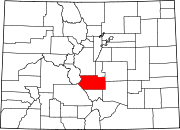
located in the Cañon City
Cañon City, Colorado
The City of Cañon City is a Home Rule Municipality that is the county seat and the most populous city of Fremont County, State of Colorado. The United States Census Bureau estimated that the city population was 16,000 in 2005. Cañon City is noted for being the location of nine state and four ...
area of the State of Colorado
Colorado
Colorado is a U.S. state that encompasses much of the Rocky Mountains as well as the northeastern portion of the Colorado Plateau and the western edge of the Great Plains...
. The Cañon City Micropolitan Statistical Area is defined as Fremont County, Colorado
Fremont County, Colorado
Fremont County is the thirteenth most populous of the 64 counties of the state of Colorado of the United States. The county is named for explorer and presidential candidate John C. Frémont. The county population was 46,824 at the 2010 census. The county seat is Cañon City. The Cañon City...
. The Micropolitan Statistical Area had a population of 46,145 at the 2000 Census
United States Census, 2000
The Twenty-second United States Census, known as Census 2000 and conducted by the Census Bureau, determined the resident population of the United States on April 1, 2000, to be 281,421,906, an increase of 13.2% over the 248,709,873 persons enumerated during the 1990 Census...
. A July 1, 2009 U.S. Census Bureau estimate placed the population at 47,815.
The Cañon City Micropolitan Statistical Area includes the City of Cañon City
Cañon City, Colorado
The City of Cañon City is a Home Rule Municipality that is the county seat and the most populous city of Fremont County, State of Colorado. The United States Census Bureau estimated that the city population was 16,000 in 2005. Cañon City is noted for being the location of nine state and four ...
, the City of Florence
Florence, Colorado
The City of Florence is a Statutory City located in Fremont County, Colorado, United States. The population was 3,653 at the 2000 census.ADX Florence, the only federal Supermax prison in the United States, is located south of Florence in an unincorporated area in Fremont County...
, the Town of Brookside
Brookside, Colorado
Brookside is a Statutory Town in Fremont County, Colorado, United States. The population was 219 at the 2000 census.-Geography:Brookside is located at ....
, the Town of Coal Creek
Coal Creek, Fremont County, Colorado
The Town of Coal Creek is a Statutory Town located in Fremont County, Colorado, United States. The population was 303 at the 2000 census.-Geography:Coal Creek is located at ....
, the Town of Rockvale
Rockvale, Colorado
Rockvale is a Statutory Town in Fremont County, Colorado, United States. The population was 426 at the 2000 census.-Geography:Rockvale is located at ....
, the Town of Williamsburg
Williamsburg, Colorado
The Town of Williamsburg is a Statutory Town located in Fremont County, Colorado, United States. The town population was 714 at the U.S. Census 2000...
, and the unincorporated area
Unincorporated area
In law, an unincorporated area is a region of land that is not a part of any municipality.To "incorporate" in this context means to form a municipal corporation, a city, town, or village with its own government. An unincorporated community is usually not subject to or taxed by a municipal government...
s of Fremont County
Fremont County, Colorado
Fremont County is the thirteenth most populous of the 64 counties of the state of Colorado of the United States. The county is named for explorer and presidential candidate John C. Frémont. The county population was 46,824 at the 2010 census. The county seat is Cañon City. The Cañon City...
.
See also
- Fremont County, ColoradoFremont County, ColoradoFremont County is the thirteenth most populous of the 64 counties of the state of Colorado of the United States. The county is named for explorer and presidential candidate John C. Frémont. The county population was 46,824 at the 2010 census. The county seat is Cañon City. The Cañon City...
- Colorado census statistical areas
- Colorado metropolitan areasColorado metropolitan areasThe metropolitan areas of the State of Colorado include the urban statistical areas defined by the United States Office of Management and Budget and regions of urban population defined by other organizations.-Census statistical areas:...
- Combined Statistical AreaCombined Statistical AreaThe United States Office of Management and Budget defines micropolitan and metropolitan statistical areas. Metropolitan and micropolitan statistical areas consist of one or more counties...
- Core Based Statistical AreaCore based statistical areaA Core Based Statistical Area is a U.S. geographic area defined by the Office of Management and Budget based around an urban center of at least 10,000 people and adjacent areas that are socioeconomically tied to the urban center by commuting. Areas defined on the basis of these standards applied...
- Metropolitan Statistical Area
- Micropolitan Statistical Area
- Table of United States Combined Statistical AreasTable of United States Combined Statistical Areasthumb|An enlargeable map of the 125 [[Combined Statistical Area]]s of the [[United States]]The United States Office of Management and Budget has defined 125 Combined Statistical Areas for the United States of America...
- Table of United States Metropolitan Statistical AreasTable of United States Metropolitan Statistical Areasthumb|An enlargeable map of the 942 [[Core Based Statistical Area]]s of the [[United States]]. The 367 [[Metropolitan Statistical Area]]s are shown in red....
- Table of United States Micropolitan Statistical AreasTable of United States Micropolitan Statistical Areasthumb|An enlargeable map of the 942 [[Core Based Statistical Area]]s of the [[United States]]. The 576 [[Micropolitan Statistical Area]]s are shown in blue....
- Table of United States primary census statistical areas
- Larger urban regions that contain the Cañon City Micropolitan Statistical Area:
- Front Range Urban CorridorFront Range Urban CorridorThe Front Range Urban Corridor is an oblong region of urban population located along the eastern face of the Southern Rocky Mountains in the U.S. states of Colorado and Wyoming. The corridor derives its name from the Front Range, the mountain range that defines the west central boundary of the...
- South Central Colorado Urban AreaSouth Central Colorado Urban Areathumb|240px|An enlargeable map of the four-county South Central Colorado Urban AreaThe South Central Colorado Urban Area comprises the Colorado Springs Metropolitan Statistical Area, the Pueblo Metropolitan Statistical Area, and the Cañon City Micropolitan Statistical Area in the central and south...
- Front Range Urban Corridor
- Census statistical areas adjacent to the Cañon City Micropolitan Statistical Area:
- Colorado Springs Metropolitan Statistical AreaColorado Springs Metropolitan Statistical AreaThe Colorado Springs Metropolitan Statistical Area is a United States Census Bureau defined Metropolitan Statistical Area located in the Colorado Springs region of the State of Colorado. The Census Bureau estimates that the population was 647,758 in 2010, a 20.48% increase since 2000. The...
- Denver-Aurora Metropolitan Statistical Area
- Denver-Aurora-Boulder Combined Statistical AreaDenver-Aurora-Boulder Combined Statistical Areathumb|300px|Map of the 12-county Denver-Aurora-Boulder Combined Statistical AreaThe Denver-Aurora-Boulder, CO Combined Statistical Area is a United States Census Bureau defined Combined Statistical Area located in the Denver region of the state of Colorado...
- Pueblo Metropolitan Statistical Area
- Colorado Springs Metropolitan Statistical Area