

Smith Point County Park
Encyclopedia
Smith Point County Park is a park located fronting on the Atlantic Ocean on the east end of Fire Island, New York
, United States, in central Long Island
by Shirley
. It is the largest park owned by Suffolk County, New York
.
The park derives its name from Smith Point, a peninsula on the Long Island mainland that extends into Bellport Bay. The peninsula was named for William "Tangier" Smith, who in the 17th century owned 50 miles (80.5 km) of ocean-front property in the Manor of St. George. The park does not own the Smith Point peninsula.
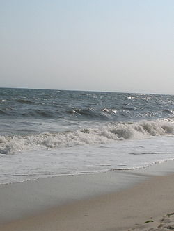
of Fire Island, is a haven for sportsmen, surfers and beach lovers. An extremely popular facility, the park has white sands, rolling Atlantic surf and an adjoining camping facility that attract both Suffolk County residents and tourists each summer.
Reservations are required for all the sites in the campground. All sites have water, and many have electric hookups and sewers. Outer beach camping is available on first come, first served basis, beach conditions permitting.
A nationally recognized team of lifeguard
s makes Smith Point its home base, providing ocean visitors with safety protection. With permits, people may drive off-road vehicles on the western portion of the outer beach. All beach-goers are advised to respect the protective fencing that marks nest sites of endangered shorebirds inhabiting the ocean
and bay
beaches.
Special events are scheduled throughout the summer months at Smith Point County Park.
William Floyd Parkway provides access to the beach and rest of the park. It crosses Narrow Bay on the two-lane Smith Point Bridge
. Large parking fields with tunnels to the seashore are available at the end of the Parkway.
A jeep road (with access by permit only) extends to the end of the island. This road as well as the main road along the beach(Suffolk CR 75) was originally intended to be part of the Ocean Parkway Extension. Suffolk Transit's 7E route also serves the beach on a seasonal basis, connecting it with points in Mastic
, Mastic Beach
, and Shirley
, and the Mastic–Shirley Long Island Rail Road
station on the Montauk Branch
. From 1983-Late 1990s Suffolk Transit also ran a bus during the summer from Smith Haven Mall to Smith Point called the S74.
The park extends from the east end of the Fire Island Wilderness portion of the National Seashore to a strip of Town of Brookhaven parkland running between this park and the west side of Cupsogue Beach County Park
which occupies both ends of Moriches Inlet
. Smith Point is a great starting point to explore Fire Island National Seashore
and its wilderness areas. A favorite hike is to walk a mile or so behind the dunes on Burma Road and back on the ocean side. The old road leads up to Old Inlet. You can return with an ocean-side walk. Along the way you can spot deer, pick beach plums during the right season, listen to birds and explore several pine groves.
The Fire Island Wilderness Visitor Center is located at the southernmost end of William Floyd Parkway, adjacent to Smith Point County Park. This is Fire Island National Seashore
's eastern gateway to the Otis Pike Fire Island High Dune Wilderness
, the only federally designated wilderness area in New York State.
 On July 17, 1996, TWA Flight 800
, a Boeing 747-131
en route from New York City
to Paris, France and Rome, Italy, crashed at sea 14 miles (22.5 km) away from the park; all passengers and crew were killed.
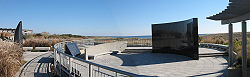
The TWA Flight 800 International Memorial was dedicated in a 2 acres (8,093.7 m²) parcel immediately adjoining the main pavilion at the park on July 14, 2004. Funds for the memorial were raised by the Families of TWA Flight 800 Association. The memorial includes landscaped grounds and flags from the 14 countries of the victims. The curved black granite
memorial has names engraved on one side and an illustration on the other of a wave releasing 230 seagulls into the sky. In July 2006 the association added an abstract design of a 10 feet (3 m) high lighthouse in black granite designed by Harry Edward Seaman, who had lost a cousin in the crash. The lighthouse
sits above a tomb holding many of the victims' personal belongings.
Fire Island, New York
Fire Island is one of the outer barrier islands adjacent to the south shore of Long Island, New York. It is approximately long and varies between broad. Fire Island is part of Suffolk County. It comprises a number of hamlets, census-designated places , and villages, all of which lie within the...
, United States, in central Long Island
Long Island
Long Island is an island located in the southeast part of the U.S. state of New York, just east of Manhattan. Stretching northeast into the Atlantic Ocean, Long Island contains four counties, two of which are boroughs of New York City , and two of which are mainly suburban...
by Shirley
Shirley, New York
Shirley is a hamlet in Suffolk County, New York, United States. As of the 2000 census, Shirley population was 26,395....
. It is the largest park owned by Suffolk County, New York
Suffolk County, New York
Suffolk County is a county located in the U.S. state of New York on the eastern portion of Long Island. As of the 2010 census, the population was 1,493,350. It was named for the county of Suffolk in England, from which its earliest settlers came...
.
The park derives its name from Smith Point, a peninsula on the Long Island mainland that extends into Bellport Bay. The peninsula was named for William "Tangier" Smith, who in the 17th century owned 50 miles (80.5 km) of ocean-front property in the Manor of St. George. The park does not own the Smith Point peninsula.
Overview
Smith Point Park, located on the barrier islandBarrier island
Barrier islands, a coastal landform and a type of barrier system, are relatively narrow strips of sand that parallel the mainland coast. They usually occur in chains, consisting of anything from a few islands to more than a dozen...
of Fire Island, is a haven for sportsmen, surfers and beach lovers. An extremely popular facility, the park has white sands, rolling Atlantic surf and an adjoining camping facility that attract both Suffolk County residents and tourists each summer.
Reservations are required for all the sites in the campground. All sites have water, and many have electric hookups and sewers. Outer beach camping is available on first come, first served basis, beach conditions permitting.
A nationally recognized team of lifeguard
Lifeguard
A lifeguard supervises the safety and rescue of swimmers, surfers, and other water sports participants such as in a swimming pool, water park, or beach. Lifeguards are strong swimmers and trained in first aid, certified in water rescue using a variety of aids and equipment depending on...
s makes Smith Point its home base, providing ocean visitors with safety protection. With permits, people may drive off-road vehicles on the western portion of the outer beach. All beach-goers are advised to respect the protective fencing that marks nest sites of endangered shorebirds inhabiting the ocean
Ocean
An ocean is a major body of saline water, and a principal component of the hydrosphere. Approximately 71% of the Earth's surface is covered by ocean, a continuous body of water that is customarily divided into several principal oceans and smaller seas.More than half of this area is over 3,000...
and bay
Bay
A bay is an area of water mostly surrounded by land. Bays generally have calmer waters than the surrounding sea, due to the surrounding land blocking some waves and often reducing winds. Bays also exist as an inlet in a lake or pond. A large bay may be called a gulf, a sea, a sound, or a bight...
beaches.
Special events are scheduled throughout the summer months at Smith Point County Park.
William Floyd Parkway provides access to the beach and rest of the park. It crosses Narrow Bay on the two-lane Smith Point Bridge
Smith Point Bridge
Smith Point Bridge is located on the south shore of central Long Island New York.The bridge crosses the narrows between the Great South Bay to its west and Moriches Bay to the east side of the bridge....
. Large parking fields with tunnels to the seashore are available at the end of the Parkway.
A jeep road (with access by permit only) extends to the end of the island. This road as well as the main road along the beach(Suffolk CR 75) was originally intended to be part of the Ocean Parkway Extension. Suffolk Transit's 7E route also serves the beach on a seasonal basis, connecting it with points in Mastic
Mastic, New York
Mastic is a hamlet in Suffolk County, New York, United States. The population was 15,436 at the 2000 census. Mastic is a community located in the southeast part of the Town of Brookhaven....
, Mastic Beach
Mastic Beach, New York
Mastic Beach is a village in the southeast part of the Town of Brookhaven in Suffolk County, New York, United States. The population was 11,543 at the 2000 census. The CDP is located in the general vicinity of the hamlet of Mastic Beach....
, and Shirley
Shirley, New York
Shirley is a hamlet in Suffolk County, New York, United States. As of the 2000 census, Shirley population was 26,395....
, and the Mastic–Shirley Long Island Rail Road
Long Island Rail Road
The Long Island Rail Road or LIRR is a commuter rail system serving the length of Long Island, New York. It is the busiest commuter railroad in North America, serving about 81.5 million passengers each year. Established in 1834 and having operated continuously since then, it is the oldest US...
station on the Montauk Branch
Montauk Branch
The Montauk Branch is a rail line owned and operated by the Long Island Rail Road in the U.S. state of New York. The branch runs the length of Long Island, 115 miles from Long Island City on the west to Montauk on the east...
. From 1983-Late 1990s Suffolk Transit also ran a bus during the summer from Smith Haven Mall to Smith Point called the S74.
The park extends from the east end of the Fire Island Wilderness portion of the National Seashore to a strip of Town of Brookhaven parkland running between this park and the west side of Cupsogue Beach County Park
Cupsogue Beach County Park
Cupsogue Beach County Park is a park at the west end of Westhampton Island, known locally as Dune Road, one of Long Island's easternmost Barrier Islands...
which occupies both ends of Moriches Inlet
Moriches Inlet
Moriches Inlet is an inlet connecting Moriches Bay and the Atlantic Ocean. The name Moriches comes from Meritces, a Native American who owned land on Moriches Neck....
. Smith Point is a great starting point to explore Fire Island National Seashore
Fire Island National Seashore
Fire Island National Seashore is a United States National Seashore that protects a section of Fire Island, an approximately long barrier island separated from Long Island by the Great South Bay....
and its wilderness areas. A favorite hike is to walk a mile or so behind the dunes on Burma Road and back on the ocean side. The old road leads up to Old Inlet. You can return with an ocean-side walk. Along the way you can spot deer, pick beach plums during the right season, listen to birds and explore several pine groves.
The Fire Island Wilderness Visitor Center is located at the southernmost end of William Floyd Parkway, adjacent to Smith Point County Park. This is Fire Island National Seashore
Fire Island National Seashore
Fire Island National Seashore is a United States National Seashore that protects a section of Fire Island, an approximately long barrier island separated from Long Island by the Great South Bay....
's eastern gateway to the Otis Pike Fire Island High Dune Wilderness
Otis Pike Fire Island High Dune Wilderness
The Otis Pike High Dune Wilderness Area, also known as the Otis G. Pike Wilderness Area, is a federally protected wilderness area composed of barrier islands off the south shore of Long Island, New York....
, the only federally designated wilderness area in New York State.
TWA Flight 800 International Memorial
TWA Flight 800
Trans World Airlines Flight 800 , a Boeing 747-131, exploded and crashed into the Atlantic Ocean near East Moriches, New York, on July 17, 1996, at about 20:31 EDT, 12 minutes after takeoff, killing all 230 persons on board. At the time, it was the second-deadliest U.S...
, a Boeing 747-131
Boeing 747
The Boeing 747 is a wide-body commercial airliner and cargo transport, often referred to by its original nickname, Jumbo Jet, or Queen of the Skies. It is among the world's most recognizable aircraft, and was the first wide-body ever produced...
en route from New York City
New York City
New York is the most populous city in the United States and the center of the New York Metropolitan Area, one of the most populous metropolitan areas in the world. New York exerts a significant impact upon global commerce, finance, media, art, fashion, research, technology, education, and...
to Paris, France and Rome, Italy, crashed at sea 14 miles (22.5 km) away from the park; all passengers and crew were killed.
The TWA Flight 800 International Memorial was dedicated in a 2 acres (8,093.7 m²) parcel immediately adjoining the main pavilion at the park on July 14, 2004. Funds for the memorial were raised by the Families of TWA Flight 800 Association. The memorial includes landscaped grounds and flags from the 14 countries of the victims. The curved black granite
Granite
Granite is a common and widely occurring type of intrusive, felsic, igneous rock. Granite usually has a medium- to coarse-grained texture. Occasionally some individual crystals are larger than the groundmass, in which case the texture is known as porphyritic. A granitic rock with a porphyritic...
memorial has names engraved on one side and an illustration on the other of a wave releasing 230 seagulls into the sky. In July 2006 the association added an abstract design of a 10 feet (3 m) high lighthouse in black granite designed by Harry Edward Seaman, who had lost a cousin in the crash. The lighthouse
Lighthouse
A lighthouse is a tower, building, or other type of structure designed to emit light from a system of lamps and lenses or, in older times, from a fire, and used as an aid to navigation for maritime pilots at sea or on inland waterways....
sits above a tomb holding many of the victims' personal belongings.