
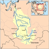
Lower Tunguska
Encyclopedia
Nizhnyaya Tunguska — is a river in Siberia
, Russia
, flows through the Irkutsk Oblast
and the Krasnoyarsk Krai
. The river is a right tributary of the Yenisei joining it at Turukhansk
(see Siberian River Routes
). Settlements on the river include Tura, Yukti and Simenga. The ice-free period on the Lower Tunguska starts in mid-June and ends in the first half of October.
. According character of stream, constitution of river's valley and its shores it can be divided into two parts: the first one starts at the source of the river and continues down to village Preobrazhenskoye and the second section of the river lies downstream of this village in a canyon-like relief.
This section of river has meandering channel approaching closely Lena River
, another great Siberian river. The minimum distance between them is as short as 15 km in the neighbourhood of town Kirensk
. All the upper stream of Nizhnyaya Tunguska is in range of the Irkutsk Oblast
.
with plateau Putorana to the north of the river, the relief alters the flow of Nizhnyaya Tunguska to west direction. The river channel frequently has lake-like widenings with lengths up to 20 km and longer. The locations with close approaches of crystalline layers create numerous rapids on the river. The most significant of them has its names: "Sakko", "Vivinskiy", "Uchamsky" and "Bolshoy" . The locations of rapids on the river has relatively high speeds of water flux reaching 3–5 m/s. In some places downstream of rapids the river channel becomes very deep with maximum depths 60–100 m. In the river's lowest flow, downstream of join with its tributary river Severnaya, Nizhnyaya Tunguska runs between limestone
rocks, which steeply rise from the water. The speeds of flow here grows to 1-1.5 m/s.
The channel and water flow of river's lower stream has its own distinguishing features, which can be met in some places at Nizhnyaya Tunguska, including follows:
In a whole, the right tributaries of Lower Tunguska dominate over left inflows adding a greater amount of water to the river than the left one. The river has not big lakes in its basin, the biggest lake is Vivi
has surface area 229 km². Incoming amount of water to Nizhnyaya Tunguska is strongly season dependant.
. The annual water discharge of river's mouth is equal to 3,680 m³/s. The minimum value observed in 1967 was equal to 2,861 m³/s, the maximum one was 4,690 m³/s in 1974 or, respectively, for estuary of the river it corresponds to ~3,093 m³/s and ~5,070 m³/s. Water supply of the river is due to melting snow and summer rains. During winter season Lower Tunguska contains little water as its basin lies in the region of permafrost
and it has not subterranean water sources. According hydrological observations during 52 years, the minimum average monthly discharge was equal to 27.8 m³/s in March 1969 — it was exceptionally dry winter — and the maximum value corresponds to June 1959 and is equal to 31,500 m³/s. The diagram below contains mean values of monthly average discharges calculated on the base of 52-year long period of observations at hydrological station "Bolshoy Porog".
The 73 per cent of entire annual water yield corresponds to the period of spring-summer season. The amplitude of water level variations in the lower stream of Nizhnyaya Tunguska is very high and is highest among all notable rivers of Russia. The narrow places of river channel jam ice during its seasonal drift creating temporal dams which blocks normal water flow and raises water level up to 30–35 m above mean value. The summer break-up and drifting of ice passes very violently, it leaves traces in the form of torned apart uprooted trees, polished rocks etc. During some days of spring freshets the river's discharge can peak at 74,000-112,000 m³/s and it supplies 50-60% of water volume to the lower stream of Yenisei river
in the time of its seasonal inundation.
, fishery
, for transportation of goods and mineral resources. Hunting
and fur trade is still a significant part of the local economy.
to Tura. As of 2010 the shipping routes of Yenisei River Steamship Lines includes village Kislokan in 1,155 km from estuary. Timber rafting is possible throughout entire course of the river.
It was suggestions and some research in 1911 to build the canal joining Lena
and Nizhnyaya Tunguska rivers in the neighbourhood of town Kirensk
. In the vicinity of this locality both rivers separated from each other no farther than 15 km, but here Nizhnyaya Tunguska is not navigable river and flows at the height 329.7 masl
, whereas river Lena flows at altitude 245.3 masl. In the beginning of 20th century the canal project was considered inexpedient due to its complexity and high cost.
After completion of this project the Lower Tunguska River will be dammed, flooding about 10000 square kilometre of forest and tundra (roughly the size of Lebanon or the islands of Hawaii), some of which contains buried nuclear waste, and displacing the indigenous Evenk population. The cost of the plant is estimated at $13 billion dollar
s, which includes costs of electric power lines. The plant will be built and operated by RusHydro
in the Krasnoyarsk region, and the electricity will be channeled to European Russia via a 3500 kilometres (2,174.8 mi) system of power lines.
Siberia
Siberia is an extensive region constituting almost all of Northern Asia. Comprising the central and eastern portion of the Russian Federation, it was part of the Soviet Union from its beginning, as its predecessor states, the Tsardom of Russia and the Russian Empire, conquered it during the 16th...
, Russia
Russia
Russia or , officially known as both Russia and the Russian Federation , is a country in northern Eurasia. It is a federal semi-presidential republic, comprising 83 federal subjects...
, flows through the Irkutsk Oblast
Irkutsk Oblast
Irkutsk Oblast is a federal subject of Russia , located in southeastern Siberia in the basins of Angara River, Lena, and Nizhnyaya Tunguska Rivers. The administrative center is the city of Irkutsk. Population: -History:...
and the Krasnoyarsk Krai
Krasnoyarsk Krai
Krasnoyarsk Krai is a federal subject of Russia . It is the second largest federal subject after the Sakha Republic, and Russia's largest krai, occupying an area of , which is 13% of the country's total territory. The administrative center of the krai is the city of Krasnoyarsk...
. The river is a right tributary of the Yenisei joining it at Turukhansk
Turukhansk
Turukhansk is a village in Krasnoyarsk Krai, Russia. It is located 1474 km north of Krasnoyarsk, at the confluence of the Yenisei and Lower Tunguska rivers. The Turukhan River joins the Yenisei about 20 km northwest. Population: 4,849 ; 8,900 ; 200...
(see Siberian River Routes
Siberian River Routes
Siberian River Routes were the main ways of communication in the Russian Siberia before the 1730s, when roads began to be built. The rivers also were of primary importance in the process of Russian exploration and colonisation of vast Siberian territories...
). Settlements on the river include Tura, Yukti and Simenga. The ice-free period on the Lower Tunguska starts in mid-June and ends in the first half of October.
Hydrography
The second largest right tributary of Yenisei joins it near town TurukhanskTurukhansk
Turukhansk is a village in Krasnoyarsk Krai, Russia. It is located 1474 km north of Krasnoyarsk, at the confluence of the Yenisei and Lower Tunguska rivers. The Turukhan River joins the Yenisei about 20 km northwest. Population: 4,849 ; 8,900 ; 200...
. According character of stream, constitution of river's valley and its shores it can be divided into two parts: the first one starts at the source of the river and continues down to village Preobrazhenskoye and the second section of the river lies downstream of this village in a canyon-like relief.
Upper stream
The first part of Lower Tunguska has length 580 km and occupies wide valley with flat slopes which is formed basically of sand and clay deposits. The speed of flow at rafts reaches 0.4-0.6 m/sec and drops significantly at the stretches of river's channel.This section of river has meandering channel approaching closely Lena River
Lena River
The Lena is the easternmost of the three great Siberian rivers that flow into the Arctic Ocean . It is the 11th longest river in the world and has the 9th largest watershed...
, another great Siberian river. The minimum distance between them is as short as 15 km in the neighbourhood of town Kirensk
Kirensk
Kirensk is a town and the administrative center of Kirensky District of Irkutsk Oblast, Russia, located at the confluence of the Kirenga and the Lena Rivers, north of Irkutsk, north-northwest of the northern tip of Lake Baikal, and northeast of Ust-Kut...
. All the upper stream of Nizhnyaya Tunguska is in range of the Irkutsk Oblast
Irkutsk Oblast
Irkutsk Oblast is a federal subject of Russia , located in southeastern Siberia in the basins of Angara River, Lena, and Nizhnyaya Tunguska Rivers. The administrative center is the city of Irkutsk. Population: -History:...
.
Lower stream
Downstream of village Preobrazhenskoye the Lower Tunguska flows in the narrow and deep valley with high, often rocky shores. Entire landscape here has volcanic originsSiberian Traps
The Siberian Traps form a large region of volcanic rock, known as a large igneous province, in the Russian region of Siberia. The massive eruptive event which formed the traps, one of the largest known volcanic events of the last 500 million years of Earth's geological history, continued for...
with plateau Putorana to the north of the river, the relief alters the flow of Nizhnyaya Tunguska to west direction. The river channel frequently has lake-like widenings with lengths up to 20 km and longer. The locations with close approaches of crystalline layers create numerous rapids on the river. The most significant of them has its names: "Sakko", "Vivinskiy", "Uchamsky" and "Bolshoy" . The locations of rapids on the river has relatively high speeds of water flux reaching 3–5 m/s. In some places downstream of rapids the river channel becomes very deep with maximum depths 60–100 m. In the river's lowest flow, downstream of join with its tributary river Severnaya, Nizhnyaya Tunguska runs between limestone
Limestone
Limestone is a sedimentary rock composed largely of the minerals calcite and aragonite, which are different crystal forms of calcium carbonate . Many limestones are composed from skeletal fragments of marine organisms such as coral or foraminifera....
rocks, which steeply rise from the water. The speeds of flow here grows to 1-1.5 m/s.
The channel and water flow of river's lower stream has its own distinguishing features, which can be met in some places at Nizhnyaya Tunguska, including follows:
- The stripes of stones with sizes 10–40 cm, which stretches near water along shore line. This peculiar feature of arctic stony rivers with local name "bechevnick" is being formed during every seasonal period of ice drift and river inundation at spring. At some locations this sort of pebbles is polished and pressed together to that extent that it creates a cobbled road of its own kind.
- The slopes of river canyon during its evolution underwent stone avalanchesLandslideA landslide or landslip is a geological phenomenon which includes a wide range of ground movement, such as rockfalls, deep failure of slopes and shallow debris flows, which can occur in offshore, coastal and onshore environments...
which formed stone runStone runA stone run is a conspicuous rock landform, result of the erosion of particular rock varieties caused by myriad freezing-thawing cycles taking place in periglacial conditions during the last Ice Age.The actual formation of stone runs involved no less than five processes: weathering, solifluction,...
s with sizes of individual rocks as big as 1.5 m in diameter. These slide-slopes has local name "korga" and create zones of calm backwater downstream. - The stream in the channel of Lower Tunguska sometimes forms whirlpoolWhirlpoolA whirlpool is a swirling body of water usually produced by ocean tides. The vast majority of whirlpools are not very powerful. More powerful ones are more properly termed maelstroms. Vortex is the proper term for any whirlpool that has a downdraft...
s. They originate downstream of cliffs which press the flow to the opposite shore. These whirlpools can reach depths of river floor down to 100 m deep and is most frequent during highwater periods at early summer.
Tributaries
The most significant tributaries of Nizhnyaya Tunguska are: right one — Eika, Kochechum, Yambuckan, Vivi, Tutonchana, Erachimo, Severnaya; left one - Nepa, Bolshaya Erema, Teteya, Ilimpeya, Nidym, Taymura, Uchami. The most prominent of them is river Kochechum, which joins it from the north near Tura. The average annual discharge of Kochechum is 600 m³/s, the area of its basin is nearly 100,000 km².In a whole, the right tributaries of Lower Tunguska dominate over left inflows adding a greater amount of water to the river than the left one. The river has not big lakes in its basin, the biggest lake is Vivi
Vivi Lake
Lake Vivi is a lake in the Putorana Plateau, Evenkia which has no permanent settlements along its banks. It is famous as the geographical center of Russia. The spot is marked by a 7-metre monument erected in August 1992. Nearby is an even higher cross dedicated to St. Sergius of Radonezh.-External...
has surface area 229 km². Incoming amount of water to Nizhnyaya Tunguska is strongly season dependant.
Hydrology
The value of average water discharge of Lower Tunguska gives it eleventh place amongst largest rivers of RussiaRussia
Russia or , officially known as both Russia and the Russian Federation , is a country in northern Eurasia. It is a federal semi-presidential republic, comprising 83 federal subjects...
. The annual water discharge of river's mouth is equal to 3,680 m³/s. The minimum value observed in 1967 was equal to 2,861 m³/s, the maximum one was 4,690 m³/s in 1974 or, respectively, for estuary of the river it corresponds to ~3,093 m³/s and ~5,070 m³/s. Water supply of the river is due to melting snow and summer rains. During winter season Lower Tunguska contains little water as its basin lies in the region of permafrost
Permafrost
In geology, permafrost, cryotic soil or permafrost soil is soil at or below the freezing point of water for two or more years. Ice is not always present, as may be in the case of nonporous bedrock, but it frequently occurs and it may be in amounts exceeding the potential hydraulic saturation of...
and it has not subterranean water sources. According hydrological observations during 52 years, the minimum average monthly discharge was equal to 27.8 m³/s in March 1969 — it was exceptionally dry winter — and the maximum value corresponds to June 1959 and is equal to 31,500 m³/s. The diagram below contains mean values of monthly average discharges calculated on the base of 52-year long period of observations at hydrological station "Bolshoy Porog".
The 73 per cent of entire annual water yield corresponds to the period of spring-summer season. The amplitude of water level variations in the lower stream of Nizhnyaya Tunguska is very high and is highest among all notable rivers of Russia. The narrow places of river channel jam ice during its seasonal drift creating temporal dams which blocks normal water flow and raises water level up to 30–35 m above mean value. The summer break-up and drifting of ice passes very violently, it leaves traces in the form of torned apart uprooted trees, polished rocks etc. During some days of spring freshets the river's discharge can peak at 74,000-112,000 m³/s and it supplies 50-60% of water volume to the lower stream of Yenisei river
Yenisei River
Yenisei , also written as Yenisey, is the largest river system flowing to the Arctic Ocean. It is the central of the three great Siberian rivers that flow into the Arctic Ocean...
in the time of its seasonal inundation.
Economy
The channel of Nizhnyaya Tunguska with its tributaries constitutes dense network of rivers and creeks which creates convenient summer pathways through the wide rifted valley of Eastern Siberia. Historically, the river was used as a route for the fur tradeFur trade
The fur trade is a worldwide industry dealing in the acquisition and sale of animal fur. Since the establishment of world market for in the early modern period furs of boreal, polar and cold temperate mammalian animals have been the most valued...
, fishery
Fishery
Generally, a fishery is an entity engaged in raising or harvesting fish which is determined by some authority to be a fishery. According to the FAO, a fishery is typically defined in terms of the "people involved, species or type of fish, area of water or seabed, method of fishing, class of boats,...
, for transportation of goods and mineral resources. Hunting
Hunting
Hunting is the practice of pursuing any living thing, usually wildlife, for food, recreation, or trade. In present-day use, the term refers to lawful hunting, as distinguished from poaching, which is the killing, trapping or capture of the hunted species contrary to applicable law...
and fur trade is still a significant part of the local economy.
Shippings
The navigation on the river is difficult because of a number of rifts, rapids and whirlpools. The passage of large ships and barges is possible during spring inundation and the particular years with rainy weather allows short period of navigation at the end of summer or at the start of autumn. The most problematic for the safe navigation of ships is rapids "Bolshoy", which is situated in 128–130 km from the river's mouth. In 1927 the first steamship passed this rapids and it is considered to be the start of modern navigation on the river from TurukhanskTurukhansk
Turukhansk is a village in Krasnoyarsk Krai, Russia. It is located 1474 km north of Krasnoyarsk, at the confluence of the Yenisei and Lower Tunguska rivers. The Turukhan River joins the Yenisei about 20 km northwest. Population: 4,849 ; 8,900 ; 200...
to Tura. As of 2010 the shipping routes of Yenisei River Steamship Lines includes village Kislokan in 1,155 km from estuary. Timber rafting is possible throughout entire course of the river.
It was suggestions and some research in 1911 to build the canal joining Lena
Lena River
The Lena is the easternmost of the three great Siberian rivers that flow into the Arctic Ocean . It is the 11th longest river in the world and has the 9th largest watershed...
and Nizhnyaya Tunguska rivers in the neighbourhood of town Kirensk
Kirensk
Kirensk is a town and the administrative center of Kirensky District of Irkutsk Oblast, Russia, located at the confluence of the Kirenga and the Lena Rivers, north of Irkutsk, north-northwest of the northern tip of Lake Baikal, and northeast of Ust-Kut...
. In the vicinity of this locality both rivers separated from each other no farther than 15 km, but here Nizhnyaya Tunguska is not navigable river and flows at the height 329.7 masl
Meters above sea level
Meters above sea Level is a standard metric measurement of the elevation of a location in reference to historic mean sea level; the determination of what actually constitutes mean sea level over time however, may be determined by other parameters, such as the effects of climate history and climate...
, whereas river Lena flows at altitude 245.3 masl. In the beginning of 20th century the canal project was considered inexpedient due to its complexity and high cost.
Planned damming
The plans to dam the river existed since soviet period starting with eightieth years of 20th century. These plans were the subject of critics by ecologists. The construction also became impossible after disintegration of Soviet Union due to economic reasons. In 2005-2010 the interest to this project and the discussion of it revived to some extent. According news media the construction of the Turukhanskaya hydroelectric powerplant would begin as soon as in 2010. As the precise date of works start is not known yet, it is more reliable that they can begin between 2010-2020.After completion of this project the Lower Tunguska River will be dammed, flooding about 10000 square kilometre of forest and tundra (roughly the size of Lebanon or the islands of Hawaii), some of which contains buried nuclear waste, and displacing the indigenous Evenk population. The cost of the plant is estimated at $13 billion dollar
Dollar
The dollar is the name of the official currency of many countries, including Australia, Belize, Canada, Ecuador, El Salvador, Hong Kong, New Zealand, Singapore, Taiwan, and the United States.-Etymology:...
s, which includes costs of electric power lines. The plant will be built and operated by RusHydro
RusHydro
RusHydro , previously known as Hydro-OGK, is a Russian hydroelectricity company. As of 2008 it has a capacity of 25 gigawatts. It is the world's second-largest hydroelectric power producer and is the country's largest power-generating company and the largest successor to RAO UES...
in the Krasnoyarsk region, and the electricity will be channeled to European Russia via a 3500 kilometres (2,174.8 mi) system of power lines.
Notable facts
- The colonisation history of Western SiberiaWest Siberian PlainThe West Siberian Plain is a large plain that occupies the western portion of Siberia, between the Ural Mountains in the west and the Yenisei River in the east, and by the Altay Mountains on the South-East. Much of the plain is poorly drained and consists of some of the world's largest swamps and...
by russians since 17th-18th centuries was reflected in various names which had river at different times. At some periods it was called Troitskaya Tunguska , Monastyrskaya Tunguska and Mangaseyan Tunguska (see Mangaseya).
- In literature river Nizhnyaya Tunguska is described in the novel "Sullen river" of Vyacheslav ShishkovVyacheslav ShishkovVyacheslav Yakovlevich Shishkov was a Soviet and Russian writer known for his descriptions of Siberia. He was awarded the Stalin Prize posthumously ....
. This writer of the first half of 20th century had visited the river during expedition in 1911, the name Sullen river was taken from siberian song.
- Existing sources indicate that the annual average discharge of water at mouth of its tributary Severnaya is equal to 300 m³/s. As this river joins Lower Tunguska downstream of hydrological station "Bolshoy Porog" it means that the known average discharge at mouth of Lower Tunguska is significantly underestimated. It must be in range 3,700-3,900 m³/s.