
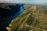
Lake Burragorang
Encyclopedia
Lake Burragorang is the water storage impounded by Warragamba Dam
. It collects the waters of the Coxs, Kowmung
, Nattai
, Wingecarribee
, and Wollondilly
Rivers. It is the major water storage for Sydney
, Australia
. It is located in the heart of the Blue Mountains, within the Greater Blue Mountains Area
World Heritage Site
.
There are fears, however, that population pressures may stretch the reservoir's ability to furnish Sydneysiders with needed water well into the 21st centuryhttp://www.population.org.au/pressrm/pub/Coxs_River_Carrying_Capacity.pdf. The city's population is rising by about 50,000 every year, and water restrictions were imposed late in 2003; a serious drought
would complicate matters.
There have been times when the lake has been seriously depleted. Since it was last full in 1998 the Warragamba Dam
catchment area has experienced extremely low rainfall, and on 8 Feb 2007 the lake recorded an all time low of 32.5% of capacity, although this had returned to 60% by late 2008. To prevent any chances of water supply failure, the NSW State government approved the building of a Desalination plant at Kurnell
to augment Sydney's water supply.
. Limited public vehicle access is allowed on fire trail W4 from Sheahys Creek to Yerranderie.
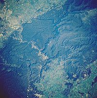
In the upper left corner of the view (below) looking roughly southeastwards are Sydney's western suburb
s. A crooked corridor of development may also be seen leading through the forested mountains to Sydney suburbs of Katoomba and Blackheath
(near the centre) and beyond.
Warragamba Dam
Warragamba Dam is the primary water source for the Australian city of Sydney. It is approximately to the west of Sydney on the Warragamba River, a tributary of the Hawkesbury River, and impounds Lake Burragorang.- Overview :...
. It collects the waters of the Coxs, Kowmung
Kowmung River
-References:...
, Nattai
Nattai River
-References:...
, Wingecarribee
Wingecarribee River
The Wingecarribee River rises on the heights at Robertson, fictional home of Babe the pig. It flows westwards, away from the sea, across the Southern Highlands plateau, near Bowral and Moss Vale, to Berrima...
, and Wollondilly
Wollondilly River
The Wollondilly River is a perennial river in New South Wales, Australia. It was originally a tributary of the Warragamba River, and hence of the Nepean and Hawkesbury Rivers...
Rivers. It is the major water storage for Sydney
Sydney
Sydney is the most populous city in Australia and the state capital of New South Wales. Sydney is located on Australia's south-east coast of the Tasman Sea. As of June 2010, the greater metropolitan area had an approximate population of 4.6 million people...
, Australia
Australia
Australia , officially the Commonwealth of Australia, is a country in the Southern Hemisphere comprising the mainland of the Australian continent, the island of Tasmania, and numerous smaller islands in the Indian and Pacific Oceans. It is the world's sixth-largest country by total area...
. It is located in the heart of the Blue Mountains, within the Greater Blue Mountains Area
Greater Blue Mountains Area
The Greater Blue Mountains Area is a World Heritage Site in the Blue Mountains of New South Wales, Australia. It was inscribed on the World Heritage List at the 24th Session of the World Heritage Committee, held in Cairns from 27 November to 2 December 2000...
World Heritage Site
World Heritage Site
A UNESCO World Heritage Site is a place that is listed by the UNESCO as of special cultural or physical significance...
.
Pre-lake history
Before the construction of the Dam, Burragorang Valley had been inhabited by white settlers since the 19th century. A number of farming towns (including the town of Burragorang) and coal mines were located in the area. All of these are now underwater.http://www.stonequarry.com.au/nature/burragorang.htmlCapacity
The reservoir's usable capacity is 2,027,000,000,000 L. Before the Deep Water Storage Recovery project completed in April 2006, the usable capacity was 1,857,000,000,000 L.There are fears, however, that population pressures may stretch the reservoir's ability to furnish Sydneysiders with needed water well into the 21st centuryhttp://www.population.org.au/pressrm/pub/Coxs_River_Carrying_Capacity.pdf. The city's population is rising by about 50,000 every year, and water restrictions were imposed late in 2003; a serious drought
Drought
A drought is an extended period of months or years when a region notes a deficiency in its water supply. Generally, this occurs when a region receives consistently below average precipitation. It can have a substantial impact on the ecosystem and agriculture of the affected region...
would complicate matters.
There have been times when the lake has been seriously depleted. Since it was last full in 1998 the Warragamba Dam
Warragamba Dam
Warragamba Dam is the primary water source for the Australian city of Sydney. It is approximately to the west of Sydney on the Warragamba River, a tributary of the Hawkesbury River, and impounds Lake Burragorang.- Overview :...
catchment area has experienced extremely low rainfall, and on 8 Feb 2007 the lake recorded an all time low of 32.5% of capacity, although this had returned to 60% by late 2008. To prevent any chances of water supply failure, the NSW State government approved the building of a Desalination plant at Kurnell
Kurnell Desalination Plant
The Sydney Desalination Plant is a drinking water supply project operated by Veolia Water Australia Pty Ltd on behalf of Sydney Water, Sydney's State-owned water supply corporation. It is located in the Kurnell industrial estate area, in Sydney's southern suburbs. The desalination plant itself was...
to augment Sydney's water supply.
Public Access
Lake Burragorang is surrounded by a 3 km wide exclusion zone to protect the integrity of the water supply; access into this zone is restricted. There are two access corridors for bushwalkers: Mount Mouin to Mount Cookem and Belloon Pass to YerranderieYerranderie, New South Wales
Yerranderrie is a ghost town located near Kanangra-Boyd National Park of New South Wales, Australia in Wollondilly Shire.-History:Yerranderie was formerly a silver mining town of 2000 people, but the mining industry collapsed in 1927, and the town was cut off from direct access from Sydney by the...
. Limited public vehicle access is allowed on fire trail W4 from Sheahys Creek to Yerranderie.
Power Station
A hydroelectric power station at Warragamba Dam begins operating once the level in the reservoir reaches to within one metre of full capacity. Its output is 50 MW, but the dam water level has not been high enough for it to operate since 1998.In the upper left corner of the view (below) looking roughly southeastwards are Sydney's western suburb
Suburb
The word suburb mostly refers to a residential area, either existing as part of a city or as a separate residential community within commuting distance of a city . Some suburbs have a degree of administrative autonomy, and most have lower population density than inner city neighborhoods...
s. A crooked corridor of development may also be seen leading through the forested mountains to Sydney suburbs of Katoomba and Blackheath
Blackheath, New South Wales
Blackheath is a small town located near the top of the Blue Mountains in New South Wales, Australia, 120 kilometres west north west of Sydney and 11 kilometres northwest of Katoomba. In 2006, Blackheath had a population of 4,177 people...
(near the centre) and beyond.
Lake Burragorang statistics
- Available storage (when full): 2,027,000 ML (note: the lowest depths have recently become available for supply)
- Total capacity (when full): 2,031,000 ML
- Surface area: 75 km²
- Length of lake: 52 km
- Length of foreshores: 354 km
- Deepest point: 105 m
- Catchment area: 9,051 km²
- Average annual rainfall: 840 mm