

Shatterford Hill
Encyclopedia
England
England is a country that is part of the United Kingdom. It shares land borders with Scotland to the north and Wales to the west; the Irish Sea is to the north west, the Celtic Sea to the south west, with the North Sea to the east and the English Channel to the south separating it from continental...
geographical feature that extends from Bewdley
Bewdley
Bewdley is a town and civil parish in the Wyre Forest District of Worcestershire, England, along the Severn Valley a few miles to the west of Kidderminster...
in north Worcestershire
Worcestershire
Worcestershire is a non-metropolitan county, established in antiquity, located in the West Midlands region of England. For Eurostat purposes it is a NUTS 3 region and is one of three counties that comprise the "Herefordshire, Worcestershire and Warwickshire" NUTS 2 region...
to Birdsgreen near Alveley, just over the border in Shropshire
Shropshire
Shropshire is a county in the West Midlands region of England. For Eurostat purposes, the county is a NUTS 3 region and is one of four counties or unitary districts that comprise the "Shropshire and Staffordshire" NUTS 2 region. It borders Wales to the west...
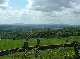
. The hill is a long ridge running up the east side of the Severn Valley and peaks at 202 metres near the village of Shatterford on the A442 road
A442 road
The A442 is a main road which passes through the counties of Worcestershire and Shropshire, in the West Midlands region of England.-Route:From Droitwich in Worcestershire it runs towards Kidderminster where it meets the A449 from Worcester...
between Kidderminster
Kidderminster
Kidderminster is a town, in the Wyre Forest district of Worcestershire, England. It is located approximately seventeen miles south-west of Birmingham city centre and approximately fifteen miles north of Worcester city centre. The 2001 census recorded a population of 55,182 in the town...
and Bridgnorth
Bridgnorth
Bridgnorth is a town in Shropshire, England, along the Severn Valley. It is split into Low Town and High Town, named on account of their elevations relative to the River Severn, which separates the upper town on the right bank from the lower on the left...
.
The ridge offers unhindered views across the Severn Valley out west to the Clee Hills
Clee Hills
The Clee Hills are a range of hills in Shropshire, England near Ludlow, consisting of Brown Clee Hill , the highest peak in Shropshire, and Titterstone Clee Hill...
, Caer Caradoc, the Long Mynd
Long Mynd
The Long Mynd in Shropshire, England, is a part of the Shropshire Hills Area of Outstanding Natural Beauty. It is south of the county town Shrewsbury, and has an area of over 22 square kilometres , most of which takes the form of a heathland plateau. Most of the land on the Long Mynd is owned by...
and on clear days to the hills of Wales
Wales
Wales is a country that is part of the United Kingdom and the island of Great Britain, bordered by England to its east and the Atlantic Ocean and Irish Sea to its west. It has a population of three million, and a total area of 20,779 km²...
. To the east is Kidderminster
Kidderminster
Kidderminster is a town, in the Wyre Forest district of Worcestershire, England. It is located approximately seventeen miles south-west of Birmingham city centre and approximately fifteen miles north of Worcester city centre. The 2001 census recorded a population of 55,182 in the town...
and the Clent Hills
Clent Hills
The Clent Hills lie 9⅓ miles southwest of Birmingham city centre in Clent, Worcestershire, England. The closest towns are Stourbridge and Halesowen, both in the West Midlands conurbation. The Clent Hills range consists of, in order from north-west to south-east: Wychbury Hill, Clent Hill , and...
, and the urban West Midlands areas of Dudley beyond. To the north the Wrekin dominates the horizon near Telford
Telford
Telford is a large new town in the borough of Telford and Wrekin and ceremonial county of Shropshire, England, approximately east of Shrewsbury, and west of Birmingham...
, whilst to the south are the Malvern Hills
Malvern Hills
The Malvern Hills are a range of hills in the English counties of Worcestershire, Herefordshire and a small area of northern Gloucestershire, dominating the surrounding countryside and the towns and villages of the district of Malvern...
. Although the triangulation pillar that officially marks the summit of the hill is in a farmers field, next to a small mast, a viewpoint is provided on the Shatterford-Trimpley road with a small layby opposite.
Villages along the hill include (south to north), Trimpley
Trimpley
Trimpley is a hamlet in the parish of Kidderminster Foreign. It lies on the ridge of Shatterford Hill, north of Wribbenhall and east of Habberley. At the village lies along Trimpley Green, a small common...
, Shatterford and Romsley
Romsley, Shropshire
Romsley is a civil parish in southeast Shropshire, England. It is bounded on the north and west by Alveley and on the south by Upper Arley in Worcestershire. On its short eastern boundary it meets Compton on Kinver...
. The road following the crown of the ridge was probably the Micclan strete (great made-road), mentioned in the Anglo-Saxon bounds of Wolverley
Wolverley
Wolverley is a village, and with Cookley together, a civil parish in the Wyre Forest District of Worcestershire, England. It is located a few miles to the north west of Kidderminster, near the town of Bewdley, and the villages of Kinver and Cookley...
. This may have been part of an ancient road from Gloucester
Gloucester
Gloucester is a city, district and county town of Gloucestershire in the South West region of England. Gloucester lies close to the Welsh border, and on the River Severn, approximately north-east of Bristol, and south-southwest of Birmingham....
and Worcester
Worcester
The City of Worcester, commonly known as Worcester, , is a city and county town of Worcestershire in the West Midlands of England. Worcester is situated some southwest of Birmingham and north of Gloucester, and has an approximate population of 94,000 people. The River Severn runs through the...
to Chester
Chester
Chester is a city in Cheshire, England. Lying on the River Dee, close to the border with Wales, it is home to 77,040 inhabitants, and is the largest and most populous settlement of the wider unitary authority area of Cheshire West and Chester, which had a population of 328,100 according to the...
. FRom Shatterford through Romsley and Quatt
Quatt
Quatt is a small village in Shropshire, England in the Severn Valley. The civil parish, formally known as Quatt Malvern, has a population of 219 according to the 2001 census.It lies on the A442 south of Bridgnorth....
, thus became part of the Kidderminster
Kidderminster
Kidderminster is a town, in the Wyre Forest district of Worcestershire, England. It is located approximately seventeen miles south-west of Birmingham city centre and approximately fifteen miles north of Worcester city centre. The 2001 census recorded a population of 55,182 in the town...
to Bridgnorth
Bridgnorth
Bridgnorth is a town in Shropshire, England, along the Severn Valley. It is split into Low Town and High Town, named on account of their elevations relative to the River Severn, which separates the upper town on the right bank from the lower on the left...
turnpike, until an easier road (now A442
A442 road
The A442 is a main road which passes through the counties of Worcestershire and Shropshire, in the West Midlands region of England.-Route:From Droitwich in Worcestershire it runs towards Kidderminster where it meets the A449 from Worcester...
) was built in the 1830s.
The ridge comes to a fairly abrupt end to the south, capped by Wassell Wood, where earthworks can still be seen from fortified enclosure of unknown date. The name "Wassell" is derived from the Anglo-Saxon "Weardsetl" meaning a watchplace. This was the westernmost of a chain of such watchplaces, also including Wassell Grove (near Wychbury Hill
Wychbury Hill
Wychbury Hill is a hill situated off the A456 Birmingham Road, at Hagley, Stourbridge, on the border of West Midlands and Worcestershire.It is divided between the parish of Hagley and former parish of Pedmore. It is one of the Clent Hills. The hill offers good views across the Severn Valley as...
), Waseley Hills and Wast Hills in Alvechurch
Alvechurch
Alvechurch is a large village and civil parish of Bromsgrove district, in the northeast of the county of Worcestershire, England. Lying in the valley of the River Arrow, the nearest city is Birmingham, 17 km / 11 miles to the north, with the closest towns being Redditch, 8 km / 5 miles...
.
Below Wassell Wood to the east is Habberley Valley
Habberley, Worcestershire
Habberley was one of the hamlet of the ancient parish of Kidderminster in the county of Worcestershire, England. It is now divided so that part of it is an area of the town of Kidderminster Habberley was one of the hamlet of the ancient parish of Kidderminster in the county of Worcestershire,...
, a Local Nature Reserve
Local Nature Reserve
Local nature reserve or LNR is a designation for nature reserves in the United Kingdom. The designation has its origin in the recommendations of the Wild Life Conservation Special Committee which established the framework for nature conservation in the United Kingdom and suggested a national suite...
of lowland heathland, which is a popular picnic site locally.