

Clent Hills
Encyclopedia
The Clent Hills lie 9⅓ miles (15 km) southwest of Birmingham city centre
in Clent
, Worcestershire
, England. The closest towns are Stourbridge
and Halesowen
, both in the West Midlands
conurbation
. The Clent Hills range consists of, in order from north-west to south-east: Wychbury Hill
, Clent Hill (and Adams Hill), and Walton Hill
(and Calcot Hill). The north Worcestershire range of hills continues eastwards to include Romsley Hill
, Waseley Hills
and the Lickey Hills
.
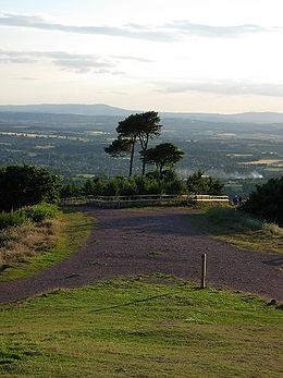
Clent Hill is the most popular hillwalking
hill in the range, although it is not often mentioned because the whole area is referred to as Clent Hills. Just under a million visitors a year are estimated to come to the hills, making them Worcestershire's most popular non-paying attraction.
 Clent appears in the Domesday Book
as "Klinter", and may be derived from the old Scandinavia
n word klint for a cliff. Once part of a Mercia
n forest, the hills contain the remains of a multi-vallate, Iron Age
hillfort on Wychbury Hill. Local historians have claimed that there was a battle between ancient Britons
and Romans fought on Clent Heath.
The Clent Hills are graced with several classically-inspired architectural works from about the 1750s. Most of them are in the private grounds of Hagley Hall
but most of them are visible from public areas. Lord Lyttelton
of Hagley Hall
constructed the Wychbury Obelisk
on Wychbury Hill in 1758, which is visible for many miles, even from the Clee Hills
. Lord Lyttelton also had constructed many other follies
including a Temple
of Theseus
, other small Greek
and Roman
temples, a full sized ruined mock castle (his lands did not contain a real one!) and 'The Four Stones' on top of Clent Hill.
The Clent Hills are also well-known for their role in the legend
of St. Kenelm, who was murdered on a hunting trip at the north eastern slopes of Clent Hill in 821 AD. St. Kenelm's Church in the parish
of Romsley
marks the site of his murder. The church is the starting point of the 60 mile walk St Kenelm's Trail
. One source of the River Stour
is within the grounds of St. Kenelm's Church.
The summits of the two largest hills, Clent Hill and Walton Hill
are now the property of the National Trust
. Clent Hill Common was managed by a Board of Conservators from 1881 to 1959. Walton Hill Common became regulated common land
(under Commons Act 1899) in 1935. Both commons and the woodlands between them were given by Worcestershire County Council and Bromsgrove Rural District Council to the National Trust
in 1959. Both hills were then managed by a Management Committee of the National Trust until 1974, when the committee became advisory only. Both the Conservators and Management Committee were largely funded by contributions from neighbouring local authorities, particularly in the Black Country
. In 1974, the hills became a country park
, managed by Hereford & Worcester County Council under the Countryside Act 1968. In 1995, management reverted to the National Trust, which set up a new Advisory Committee in 2000.
The Clent Hills were featured in the BBC
's website magazine in which Match of the Day 2
presenter Adrian Chiles
chose it as his favourite 'hidden tourist attraction'.
.
For Queen Victoria's Diamond Jubilee A. E. Housman
watched the beacons from summit of Walton Hill. He wrote in a letter to his mother that at 10 o'clock the night of 22 June 1897 (the hour designated for the event) he could see 52 just to the south and west. He did not try to count those northwards because "it was hard to tell the beacons from the ordinary illuminations of the Black Country". The one on the Malvern Hills was so large that during the day it had been visible from Walton Hill, and as it was saturated with paraffin it burned very brightly but only for an hour. By 2 o'clock, Houseman wrote that in the distance two could still be seen still burning somewhere near the Brown Clee, and three nearer, one towards Droitwich, one on Kinver Edge
(it continued to burnt brightly until dawn) and the Clent Hill beacon which was not near the summit but on the south west face.
In 1977 a bonfire beacon
was built close to the summit of Walton Hill and lit on the 6 June as one of a national chain that started with one lit by the Queen at Windsor Castle
to mark the Silver Jubilee of Elizabeth II
.
 The hills rise to a height of 1,037 ft (316 m) on Walton Hill
, with views over the Malvern Hills, Kinver Edge
, The Wrekin
, Wenlock Edge
, Shatterford Hill
, Clee Hills
and back round to Kidderminster
, Stourbridge
, Dudley
, Halesowen
and Turners Hill
. On a clear day you can even see as far as the Black Mountains
of Wales
, the Cotswolds
, the Peak District
and Charnwood Forest
. A toposcope
indicates the mountains visible. Landmarks visible from the hills include Dudley Castle
, the large Droitwich AM transmitter
s near Bromsgrove
, the large silos on the British Sugar Corporation
land in Kidderminster
, Ironbridge Power Station
, near Telford
and the nearby Wychbury Obelisk
. It is because of this that the hills are very popular with hillwalking
visitors and local ramblers groups. The hills are criss-crossed with many public footpaths. A popular means of access to Clent Hill is from Nimmings Car Park, off Hagley Wood Lane. From this an easy access walk route leads to the ridge. Another popular access is from the public car park on Adams Hill. Adams Hill is not a separate hill, but the name for the hamlet (part of the parish of Clent
) and the slope that form the south west flank of Clent Hill.
In 2009 Cooper Partnership (a firm of Chartered Landscape Architects) were commissioned to "identify and assess a selection of key views to and from the Malvern Hills" by the Malvern Hills Area of Outstanding Natural Beauty Partnership. Cooper's identified 50 key views from vantage points some on the Malvern Hills
and others from other vantage points looking at the Malverns. At 22 miles the view from the Clent Hills was the most distant. They rated importance of the view as special and the sensitivity as high and wrote that the Clent Hills had "many pedestrian and equestrian users" and in "[a] lovely environment of countryside pursuits" the vista contained a:
form a range of hills in north Worcestershire
known as the Clent-Lickey Range (or the Clent-Lickey Ridge). The largest of the Clent Hills is Walton Hill
which is 1,037 feet (316 metres) high followed by Clent Hill at 1,014 feet (309 metres). They are separated by a valley known as St. Kenelm's Pass, which starts as an escarpment
one side of which along with the sides of the two hills falls away towards Uffmoor Wood
; water flowing down this slope enters streams which become the River Stour
. The other side of the escarpment becomes a sharp V valley in which a stream flows down into Clent
village and the Walton Hill side of the valley is known as Clatterbach. In the past, before steam power replaced water power, the stream in the valley was dammed at regular intervals to provide water power for watermill
s. The remains of one such dam can be seen behind the Vine Inn in Clent which was once a mill.
 Either side of the two largest hills are two more hills. Beside Clent Hill is Wychbury Hill
and beside Walton Hill is Calcot Hill. Calcot Hill is not really a separate hill but at the end of a long spur which runs from the summit of Walton Hill for about a mile. There is a public footpath along the spur joining the two hills. Alongside the spur is another deep V shaped valley which was also dammed at frequent intervals to provide power to its mills. This stream flows on to the village of Belbroughton
in which the Nash Crown Scythe
Works used the water to power its machinery. On the other side of the valley is Romsley Hill, the valley banks of which are covered by Great Farley Wood beyond Romsley Hill are a number of lower hills (Windmill, Chapman's and Waseley) which join the Clent Hills to the Lickey Hills
in one continuous chain.
The National Trust
land on the hills encompass 0.68 square miles (1.77 square kilometres) of woodland
(both natural deciduous
and coniferous forest plantations) and heathland, important for wildlife including Fallow Deer
and Common Buzzard
, plus visiting Ring Ouzel
and Common Crossbill
.
lived at the Leasowes
and was a near neighbour of the Lyttelton family at Hagley Hall
. Shenstone Garden at the Leasowes was one of the most notable gardens in England in the mid 1700s and his Unconnected Thoughts on Gardening on of the more influential of the age.
On 30 August 1746 William Lyttelton called at the Leasowes with his friend the poet James Thomson. Shenstone later wrote a letter about the encounter which was published in 1800.
After introductions and a conversation inside the house about a valley and the brook that Lyttelton and Thomson passed on their way to the Leasowes and which had much impressed Thompson for its beauty, Shenstone invented the pair to view the vista from green behind his house. They conversed about on a small nearby feature called Farmer's Hill and Thomson suggested that Shenstone should extend his garden, but Shenstone explained to him that he would rather take what was already there and augment it "The French, it appears, have their [P]arque ornèe; and why is not Ferme ornèe as good an expression?". As his guests could not stay long owing to a dinner engagement they were unable to visit Shenstone's upper wood, but warming to Shenstone's suggestion on how to improve the landscape Shepstone wrote that the conversation continued thus:
Birmingham City Centre
Birmingham city centre is the business, retail and leisure hub of Birmingham, England. Following the removal of the Inner Ring Road, the city centre is newly defined as being the area within the Middle Ring Road. Birmingham city centre is undergoing massive redevelopment with the Big City Plan...
in Clent
Clent
Clent is a village and civil parish in the Bromsgrove District of Worcestershire, England, southwest of Birmingham and close to the edge of the West Midlands conurbation. At the 2001 census it had a population of 2,600...
, Worcestershire
Worcestershire
Worcestershire is a non-metropolitan county, established in antiquity, located in the West Midlands region of England. For Eurostat purposes it is a NUTS 3 region and is one of three counties that comprise the "Herefordshire, Worcestershire and Warwickshire" NUTS 2 region...
, England. The closest towns are Stourbridge
Stourbridge
Stourbridge is a town within the Metropolitan Borough of Dudley, in the West Midlands of England. Historically part of Worcestershire, Stourbridge was a centre of glass making, and today includes the suburbs of Amblecote, Lye, Norton, Oldswinford, Pedmore, Wollaston, Wollescote and Wordsley The...
and Halesowen
Halesowen
Halesowen is a town in the Metropolitan Borough of Dudley, in the West Midlands, England.The population, as measured by the United Kingdom Census 2001, was 55,273...
, both in the West Midlands
West Midlands (county)
The West Midlands is a metropolitan county in western central England with a 2009 estimated population of 2,638,700. It came into existence as a metropolitan county in 1974 after the passage of the Local Government Act 1972, formed from parts of Staffordshire, Worcestershire and Warwickshire. The...
conurbation
Conurbation
A conurbation is a region comprising a number of cities, large towns, and other urban areas that, through population growth and physical expansion, have merged to form one continuous urban and industrially developed area...
. The Clent Hills range consists of, in order from north-west to south-east: Wychbury Hill
Wychbury Hill
Wychbury Hill is a hill situated off the A456 Birmingham Road, at Hagley, Stourbridge, on the border of West Midlands and Worcestershire.It is divided between the parish of Hagley and former parish of Pedmore. It is one of the Clent Hills. The hill offers good views across the Severn Valley as...
, Clent Hill (and Adams Hill), and Walton Hill
Walton Hill
At 316 metres above sea level, Walton Hill is the highest point in the range of hills in northern Worcestershire known as the Clent Hills. It is the highest point for 21 miles in all directions, and as such commands an excellent panorama...
(and Calcot Hill). The north Worcestershire range of hills continues eastwards to include Romsley Hill
Romsley, Worcestershire
Romsley is a village and civil parish in the Bromsgrove District of Worcestershire, England, on the east side of the Clent Hills about 4 miles south of Halesowen. As of 2001 it has a population of 1,601....
, Waseley Hills
Waseley Hills Country Park
Waseley Hills Country Park is a Country Park, owned and managed by Worcestershire County Council's Countryside Service. It consists of rolling open hills with old hedgerows, pastures and small pockets of woodland with panoramic views over Worcestershire, England.It is just south-west of...
and the Lickey Hills
Lickey Hills
The Lickey Hills are a range of hills in Worcestershire, England, eleven miles to the south-west of the centre of Birmingham near the villages of Lickey and Barnt Green...
.
Clent Hill is the most popular hillwalking
Hillwalking
In the British Isles, the terms hillwalking or fellwalking are commonly used to describe the recreational outdoor activity of walking on hills and mountains, often with the intention of visiting their summits...
hill in the range, although it is not often mentioned because the whole area is referred to as Clent Hills. Just under a million visitors a year are estimated to come to the hills, making them Worcestershire's most popular non-paying attraction.
History
Domesday Book
Domesday Book , now held at The National Archives, Kew, Richmond upon Thames in South West London, is the record of the great survey of much of England and parts of Wales completed in 1086...
as "Klinter", and may be derived from the old Scandinavia
Scandinavia
Scandinavia is a cultural, historical and ethno-linguistic region in northern Europe that includes the three kingdoms of Denmark, Norway and Sweden, characterized by their common ethno-cultural heritage and language. Modern Norway and Sweden proper are situated on the Scandinavian Peninsula,...
n word klint for a cliff. Once part of a Mercia
Mercia
Mercia was one of the kingdoms of the Anglo-Saxon Heptarchy. It was centred on the valley of the River Trent and its tributaries in the region now known as the English Midlands...
n forest, the hills contain the remains of a multi-vallate, Iron Age
Iron Age
The Iron Age is the archaeological period generally occurring after the Bronze Age, marked by the prevalent use of iron. The early period of the age is characterized by the widespread use of iron or steel. The adoption of such material coincided with other changes in society, including differing...
hillfort on Wychbury Hill. Local historians have claimed that there was a battle between ancient Britons
Brython
The Britons were the Celtic people culturally dominating Great Britain from the Iron Age through the Early Middle Ages. They spoke the Insular Celtic language known as British or Brythonic...
and Romans fought on Clent Heath.
The Clent Hills are graced with several classically-inspired architectural works from about the 1750s. Most of them are in the private grounds of Hagley Hall
Hagley Hall
Hagley Hall is an 18th century house in Hagley, Worcestershire. It was the creation of George Lyttelton, 1st Baron Lyttelton , secretary to Frederick, Prince of Wales, poet and man of letters and briefly Chancellor of the Exchequer...
but most of them are visible from public areas. Lord Lyttelton
George Lyttelton, 1st Baron Lyttelton
George Lyttelton, 1st Baron Lyttelton PC , known as Sir George Lyttelton, Bt between 1751 and 1756, was a British politician and statesman and a patron of the arts.-Background and education:...
of Hagley Hall
Hagley Hall
Hagley Hall is an 18th century house in Hagley, Worcestershire. It was the creation of George Lyttelton, 1st Baron Lyttelton , secretary to Frederick, Prince of Wales, poet and man of letters and briefly Chancellor of the Exchequer...
constructed the Wychbury Obelisk
Wychbury Obelisk
The Wychbury Obelisk stands on Wychbury Hill, Hagley near Stourbridge, in Worcestershire, England...
on Wychbury Hill in 1758, which is visible for many miles, even from the Clee Hills
Clee Hills
The Clee Hills are a range of hills in Shropshire, England near Ludlow, consisting of Brown Clee Hill , the highest peak in Shropshire, and Titterstone Clee Hill...
. Lord Lyttelton also had constructed many other follies
Folly
In architecture, a folly is a building constructed primarily for decoration, but either suggesting by its appearance some other purpose, or merely so extravagant that it transcends the normal range of garden ornaments or other class of building to which it belongs...
including a Temple
Temple
A temple is a structure reserved for religious or spiritual activities, such as prayer and sacrifice, or analogous rites. A templum constituted a sacred precinct as defined by a priest, or augur. It has the same root as the word "template," a plan in preparation of the building that was marked out...
of Theseus
Theseus
For other uses, see Theseus Theseus was the mythical founder-king of Athens, son of Aethra, and fathered by Aegeus and Poseidon, both of whom Aethra had slept with in one night. Theseus was a founder-hero, like Perseus, Cadmus, or Heracles, all of whom battled and overcame foes that were...
, other small Greek
Greek mythology
Greek mythology is the body of myths and legends belonging to the ancient Greeks, concerning their gods and heroes, the nature of the world, and the origins and significance of their own cult and ritual practices. They were a part of religion in ancient Greece...
and Roman
Roman mythology
Roman mythology is the body of traditional stories pertaining to ancient Rome's legendary origins and religious system, as represented in the literature and visual arts of the Romans...
temples, a full sized ruined mock castle (his lands did not contain a real one!) and 'The Four Stones' on top of Clent Hill.
The Clent Hills are also well-known for their role in the legend
Legend
A legend is a narrative of human actions that are perceived both by teller and listeners to take place within human history and to possess certain qualities that give the tale verisimilitude...
of St. Kenelm, who was murdered on a hunting trip at the north eastern slopes of Clent Hill in 821 AD. St. Kenelm's Church in the parish
Parish
A parish is a territorial unit historically under the pastoral care and clerical jurisdiction of one parish priest, who might be assisted in his pastoral duties by a curate or curates - also priests but not the parish priest - from a more or less central parish church with its associated organization...
of Romsley
Romsley, Worcestershire
Romsley is a village and civil parish in the Bromsgrove District of Worcestershire, England, on the east side of the Clent Hills about 4 miles south of Halesowen. As of 2001 it has a population of 1,601....
marks the site of his murder. The church is the starting point of the 60 mile walk St Kenelm's Trail
St Kenelm's Trail
St Kenelm’s Trail is a walk originally devised by John Price, which links the two places most commonly associated with the legend of St Kenelm. These are the Clent Hills, south of Birmingham, identified as the scene of his supposed murder and the small Gloucestershire town of Winchcombe, near...
. One source of the River Stour
River Stour, Worcestershire
The Stour is a river flowing through the counties of Worcestershire, the West Midlands and Staffordshire in the West Midlands region of England. The Stour is a major tributary of the River Severn, and it is about in length...
is within the grounds of St. Kenelm's Church.
The summits of the two largest hills, Clent Hill and Walton Hill
Walton Hill
At 316 metres above sea level, Walton Hill is the highest point in the range of hills in northern Worcestershire known as the Clent Hills. It is the highest point for 21 miles in all directions, and as such commands an excellent panorama...
are now the property of the National Trust
National Trust for Places of Historic Interest or Natural Beauty
The National Trust for Places of Historic Interest or Natural Beauty, usually known as the National Trust, is a conservation organisation in England, Wales and Northern Ireland...
. Clent Hill Common was managed by a Board of Conservators from 1881 to 1959. Walton Hill Common became regulated common land
Common land
Common land is land owned collectively or by one person, but over which other people have certain traditional rights, such as to allow their livestock to graze upon it, to collect firewood, or to cut turf for fuel...
(under Commons Act 1899) in 1935. Both commons and the woodlands between them were given by Worcestershire County Council and Bromsgrove Rural District Council to the National Trust
National Trust for Places of Historic Interest or Natural Beauty
The National Trust for Places of Historic Interest or Natural Beauty, usually known as the National Trust, is a conservation organisation in England, Wales and Northern Ireland...
in 1959. Both hills were then managed by a Management Committee of the National Trust until 1974, when the committee became advisory only. Both the Conservators and Management Committee were largely funded by contributions from neighbouring local authorities, particularly in the Black Country
Black Country
The Black Country is a loosely defined area of the English West Midlands conurbation, to the north and west of Birmingham, and to the south and east of Wolverhampton. During the industrial revolution in the 19th century this area had become one of the most intensely industrialised in the nation...
. In 1974, the hills became a country park
Country park
A country park is an area designated for people to visit and enjoy recreation in a countryside environment.-History:In the United Kingdom the term 'Country Park' has a special meaning. There are over 400 Country Parks in England alone . Most Country Parks were designated in the 1970s, under the...
, managed by Hereford & Worcester County Council under the Countryside Act 1968. In 1995, management reverted to the National Trust, which set up a new Advisory Committee in 2000.
The Clent Hills were featured in the BBC
BBC
The British Broadcasting Corporation is a British public service broadcaster. Its headquarters is at Broadcasting House in the City of Westminster, London. It is the largest broadcaster in the world, with about 23,000 staff...
's website magazine in which Match of the Day 2
Match of the Day 2
Match of the Day 2 is a football highlights programme shown on BBC Two in the United Kingdom...
presenter Adrian Chiles
Adrian Chiles
Adrian Chiles is a British television and radio presenter, currently working for ITV Sport presenting football coverage....
chose it as his favourite 'hidden tourist attraction'.
Beacons
In 1588 a beacon was placed on the Bicknall as part of the chain set up to warn of the approach of the Spanish ArmadaSpanish Armada
This article refers to the Battle of Gravelines, for the modern navy of Spain, see Spanish NavyThe Spanish Armada was the Spanish fleet that sailed against England under the command of the Duke of Medina Sidonia in 1588, with the intention of overthrowing Elizabeth I of England to stop English...
.
For Queen Victoria's Diamond Jubilee A. E. Housman
A. E. Housman
Alfred Edward Housman , usually known as A. E. Housman, was an English classical scholar and poet, best known to the general public for his cycle of poems A Shropshire Lad. Lyrical and almost epigrammatic in form, the poems were mostly written before 1900...
watched the beacons from summit of Walton Hill. He wrote in a letter to his mother that at 10 o'clock the night of 22 June 1897 (the hour designated for the event) he could see 52 just to the south and west. He did not try to count those northwards because "it was hard to tell the beacons from the ordinary illuminations of the Black Country". The one on the Malvern Hills was so large that during the day it had been visible from Walton Hill, and as it was saturated with paraffin it burned very brightly but only for an hour. By 2 o'clock, Houseman wrote that in the distance two could still be seen still burning somewhere near the Brown Clee, and three nearer, one towards Droitwich, one on Kinver Edge
Kinver Edge
Kinver Edge is a high heath and woodland escarpment just west of Kinver, about four miles west of Stourbridge, and four miles north of Kidderminster, and is on the border between Worcestershire and Staffordshire, England. It is now owned by the National Trust....
(it continued to burnt brightly until dawn) and the Clent Hill beacon which was not near the summit but on the south west face.
In 1977 a bonfire beacon
Beacon
A beacon is an intentionally conspicuous device designed to attract attention to a specific location.Beacons can also be combined with semaphoric or other indicators to provide important information, such as the status of an airport, by the colour and rotational pattern of its airport beacon, or of...
was built close to the summit of Walton Hill and lit on the 6 June as one of a national chain that started with one lit by the Queen at Windsor Castle
Windsor Castle
Windsor Castle is a medieval castle and royal residence in Windsor in the English county of Berkshire, notable for its long association with the British royal family and its architecture. The original castle was built after the Norman invasion by William the Conqueror. Since the time of Henry I it...
to mark the Silver Jubilee of Elizabeth II
Silver Jubilee of Elizabeth II
The Silver Jubilee of Elizabeth II marked the 25th anniversary of Queen Elizabeth II's accession to the throne of the United Kingdom, Canada, Australia, New Zealand, and other Commonwealth realms...
.
View
Walton Hill
At 316 metres above sea level, Walton Hill is the highest point in the range of hills in northern Worcestershire known as the Clent Hills. It is the highest point for 21 miles in all directions, and as such commands an excellent panorama...
, with views over the Malvern Hills, Kinver Edge
Kinver Edge
Kinver Edge is a high heath and woodland escarpment just west of Kinver, about four miles west of Stourbridge, and four miles north of Kidderminster, and is on the border between Worcestershire and Staffordshire, England. It is now owned by the National Trust....
, The Wrekin
The Wrekin
The Wrekin is a hill in east Shropshire, England. It is located some west of Telford, on the border between the unitary authorities of Shropshire and Telford and Wrekin. Rising to a height of above the Shropshire Plain, it is a prominent and well-known landmark, marking the entrance to Shropshire...
, Wenlock Edge
Wenlock Edge
Wenlock Edge is a limestone escarpment near Much Wenlock, Shropshire, England. It is long and runs from South West to North East between Craven Arms and Much Wenlock. It is roughly 330 metres high...
, Shatterford Hill
Shatterford Hill
Shatterford Hill is an English geographical feature that extends from Bewdley in north Worcestershire to Birdsgreen near Alveley, just over the border in Shropshire...
, Clee Hills
Clee Hills
The Clee Hills are a range of hills in Shropshire, England near Ludlow, consisting of Brown Clee Hill , the highest peak in Shropshire, and Titterstone Clee Hill...
and back round to Kidderminster
Kidderminster
Kidderminster is a town, in the Wyre Forest district of Worcestershire, England. It is located approximately seventeen miles south-west of Birmingham city centre and approximately fifteen miles north of Worcester city centre. The 2001 census recorded a population of 55,182 in the town...
, Stourbridge
Stourbridge
Stourbridge is a town within the Metropolitan Borough of Dudley, in the West Midlands of England. Historically part of Worcestershire, Stourbridge was a centre of glass making, and today includes the suburbs of Amblecote, Lye, Norton, Oldswinford, Pedmore, Wollaston, Wollescote and Wordsley The...
, Dudley
Dudley
Dudley is a large town in the West Midlands county of England. At the 2001 census , the Dudley Urban Sub Area had a population of 194,919, making it the 26th largest settlement in England, the second largest town in the United Kingdom behind Reading, and the largest settlement in the UK without...
, Halesowen
Halesowen
Halesowen is a town in the Metropolitan Borough of Dudley, in the West Midlands, England.The population, as measured by the United Kingdom Census 2001, was 55,273...
and Turners Hill
Turners Hill, West Midlands
Turners Hill or Turner's Hill is the highest hill in the West Midlands, England, at 271m above sea level. The hill is situated on the border of Dudley and Rowley Regis, in the Metropolitan Borough of Sandwell , in a rural part of the predominantly industrial Black Country.The hill can be seen from...
. On a clear day you can even see as far as the Black Mountains
Black Mountains, Wales
The Black Mountains are a group of hills spread across parts of Powys and Monmouthshire in southeast Wales, and extending across the national border into Herefordshire, England. They are the easternmost of the four ranges of hills that comprise the Brecon Beacons National Park, and are frequently...
of Wales
Wales
Wales is a country that is part of the United Kingdom and the island of Great Britain, bordered by England to its east and the Atlantic Ocean and Irish Sea to its west. It has a population of three million, and a total area of 20,779 km²...
, the Cotswolds
Cotswolds
The Cotswolds are a range of hills in west-central England, sometimes called the Heart of England, an area across and long. The area has been designated as the Cotswold Area of Outstanding Natural Beauty...
, the Peak District
Peak District
The Peak District is an upland area in central and northern England, lying mainly in northern Derbyshire, but also covering parts of Cheshire, Greater Manchester, Staffordshire, and South and West Yorkshire....
and Charnwood Forest
Charnwood Forest
Charnwood Forest is an upland tract in north-western Leicestershire, England, bounded by Leicester, Loughborough, and Coalville. The area is undulating, rocky and picturesque, with barren areas. It also has some extensive tracts of woodland; its elevation is generally 600 ft and upwards, the area...
. A toposcope
Toposcope
A toposcope or topograph is a marker erected on hills, mountains or high places which indicates the direction, and usually the distance, to notable landscape features which can be seen from that point...
indicates the mountains visible. Landmarks visible from the hills include Dudley Castle
Dudley Castle
Dudley Castle is a ruined castle in the town of Dudley, West Midlands, England. Dudley Zoo is located in its grounds. The location, Castle Hill, is an outcrop of Wenlock Group limestone that was extensively quarried during the Industrial Revolution, and which now along with Wren's Nest Hill is a...
, the large Droitwich AM transmitter
Droitwich AM transmitter
The Droitwich transmitting station is a large broadcasting facility for longwave and mediumwave transmissions, established in 1934 in the civil parish of Dodderhill, just outside the village of Wychbold, which is near Droitwich, Worcestershire, England...
s near Bromsgrove
Bromsgrove
Bromsgrove is a town in Worcestershire, England. The town is about north east of Worcester and south west of Birmingham city centre. It had a population of 29,237 in 2001 with a small ethnic minority and is in Bromsgrove District.- History :Bromsgrove is first documented in the early 9th century...
, the large silos on the British Sugar Corporation
British Sugar Corporation
British Sugar plc is a subsidiary of Associated British Foods and the sole British producer of sugar from sugar beet.British Sugar processes all sugar beet grown in the UK and produces about half of the UK's quota of sugar, with the remainder covered by Tate & Lyle and imports...
land in Kidderminster
Kidderminster
Kidderminster is a town, in the Wyre Forest district of Worcestershire, England. It is located approximately seventeen miles south-west of Birmingham city centre and approximately fifteen miles north of Worcester city centre. The 2001 census recorded a population of 55,182 in the town...
, Ironbridge Power Station
Ironbridge Power Station
The Ironbridge power stations refers to a series of two coal-fired power stations which have occupied a site on the banks of the River Severn at Buildwas in Shropshire, England. The current Ironbridge B power station is operated by E.ON UK...
, near Telford
Telford
Telford is a large new town in the borough of Telford and Wrekin and ceremonial county of Shropshire, England, approximately east of Shrewsbury, and west of Birmingham...
and the nearby Wychbury Obelisk
Wychbury Obelisk
The Wychbury Obelisk stands on Wychbury Hill, Hagley near Stourbridge, in Worcestershire, England...
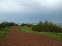
. It is because of this that the hills are very popular with hillwalking
Hillwalking
In the British Isles, the terms hillwalking or fellwalking are commonly used to describe the recreational outdoor activity of walking on hills and mountains, often with the intention of visiting their summits...
visitors and local ramblers groups. The hills are criss-crossed with many public footpaths. A popular means of access to Clent Hill is from Nimmings Car Park, off Hagley Wood Lane. From this an easy access walk route leads to the ridge. Another popular access is from the public car park on Adams Hill. Adams Hill is not a separate hill, but the name for the hamlet (part of the parish of Clent
Clent
Clent is a village and civil parish in the Bromsgrove District of Worcestershire, England, southwest of Birmingham and close to the edge of the West Midlands conurbation. At the 2001 census it had a population of 2,600...
) and the slope that form the south west flank of Clent Hill.
In 2009 Cooper Partnership (a firm of Chartered Landscape Architects) were commissioned to "identify and assess a selection of key views to and from the Malvern Hills" by the Malvern Hills Area of Outstanding Natural Beauty Partnership. Cooper's identified 50 key views from vantage points some on the Malvern Hills
Malvern Hills
The Malvern Hills are a range of hills in the English counties of Worcestershire, Herefordshire and a small area of northern Gloucestershire, dominating the surrounding countryside and the towns and villages of the district of Malvern...
and others from other vantage points looking at the Malverns. At 22 miles the view from the Clent Hills was the most distant. They rated importance of the view as special and the sensitivity as high and wrote that the Clent Hills had "many pedestrian and equestrian users" and in "[a] lovely environment of countryside pursuits" the vista contained a:
Geography
The hills along with the Lickey HillsLickey Hills
The Lickey Hills are a range of hills in Worcestershire, England, eleven miles to the south-west of the centre of Birmingham near the villages of Lickey and Barnt Green...
form a range of hills in north Worcestershire
Worcestershire
Worcestershire is a non-metropolitan county, established in antiquity, located in the West Midlands region of England. For Eurostat purposes it is a NUTS 3 region and is one of three counties that comprise the "Herefordshire, Worcestershire and Warwickshire" NUTS 2 region...
known as the Clent-Lickey Range (or the Clent-Lickey Ridge). The largest of the Clent Hills is Walton Hill
Walton Hill
At 316 metres above sea level, Walton Hill is the highest point in the range of hills in northern Worcestershire known as the Clent Hills. It is the highest point for 21 miles in all directions, and as such commands an excellent panorama...
which is 1,037 feet (316 metres) high followed by Clent Hill at 1,014 feet (309 metres). They are separated by a valley known as St. Kenelm's Pass, which starts as an escarpment
Escarpment
An escarpment is a steep slope or long cliff that occurs from erosion or faulting and separates two relatively level areas of differing elevations.-Description and variants:...
one side of which along with the sides of the two hills falls away towards Uffmoor Wood
Uffmoor Wood
Uffmoor Wood is a semi-natural woodland in Worcestershire, in theEnglish Midlands. It is one of over a thousand woods cared for by the Woodland Trust. The wood has an area of 84.84 hectares , and . Sitting at the foot of the Clent Hills and about 3 km southwest of Halesowen, Uffmoor Wood is a...
; water flowing down this slope enters streams which become the River Stour
River Stour, Worcestershire
The Stour is a river flowing through the counties of Worcestershire, the West Midlands and Staffordshire in the West Midlands region of England. The Stour is a major tributary of the River Severn, and it is about in length...
. The other side of the escarpment becomes a sharp V valley in which a stream flows down into Clent
Clent
Clent is a village and civil parish in the Bromsgrove District of Worcestershire, England, southwest of Birmingham and close to the edge of the West Midlands conurbation. At the 2001 census it had a population of 2,600...
village and the Walton Hill side of the valley is known as Clatterbach. In the past, before steam power replaced water power, the stream in the valley was dammed at regular intervals to provide water power for watermill
Watermill
A watermill is a structure that uses a water wheel or turbine to drive a mechanical process such as flour, lumber or textile production, or metal shaping .- History :...
s. The remains of one such dam can be seen behind the Vine Inn in Clent which was once a mill.
Wychbury Hill
Wychbury Hill is a hill situated off the A456 Birmingham Road, at Hagley, Stourbridge, on the border of West Midlands and Worcestershire.It is divided between the parish of Hagley and former parish of Pedmore. It is one of the Clent Hills. The hill offers good views across the Severn Valley as...
and beside Walton Hill is Calcot Hill. Calcot Hill is not really a separate hill but at the end of a long spur which runs from the summit of Walton Hill for about a mile. There is a public footpath along the spur joining the two hills. Alongside the spur is another deep V shaped valley which was also dammed at frequent intervals to provide power to its mills. This stream flows on to the village of Belbroughton
Belbroughton
Belbroughton is a village and civil parish in the Bromsgrove District of Worcestershire, England. According to the 2001 census it had a population of 2,380. It is about six miles north of Bromsgrove, six miles east of Kidderminster and four miles south of Stourbridge, in Worcestershire...
in which the Nash Crown Scythe
Scythe
A scythe is an agricultural hand tool for mowing grass, or reaping crops. It was largely replaced by horse-drawn and then tractor machinery, but is still used in some areas of Europe and Asia. The Grim Reaper is often depicted carrying or wielding a scythe...
Works used the water to power its machinery. On the other side of the valley is Romsley Hill, the valley banks of which are covered by Great Farley Wood beyond Romsley Hill are a number of lower hills (Windmill, Chapman's and Waseley) which join the Clent Hills to the Lickey Hills
Lickey Hills
The Lickey Hills are a range of hills in Worcestershire, England, eleven miles to the south-west of the centre of Birmingham near the villages of Lickey and Barnt Green...
in one continuous chain.
The National Trust
National Trust for Places of Historic Interest or Natural Beauty
The National Trust for Places of Historic Interest or Natural Beauty, usually known as the National Trust, is a conservation organisation in England, Wales and Northern Ireland...
land on the hills encompass 0.68 square miles (1.77 square kilometres) of woodland
Woodland
Ecologically, a woodland is a low-density forest forming open habitats with plenty of sunlight and limited shade. Woodlands may support an understory of shrubs and herbaceous plants including grasses. Woodland may form a transition to shrubland under drier conditions or during early stages of...
(both natural deciduous
Deciduous
Deciduous means "falling off at maturity" or "tending to fall off", and is typically used in reference to trees or shrubs that lose their leaves seasonally, and to the shedding of other plant structures such as petals after flowering or fruit when ripe...
and coniferous forest plantations) and heathland, important for wildlife including Fallow Deer
Fallow Deer
The Fallow Deer is a ruminant mammal belonging to the family Cervidae. This common species is native to western Eurasia, but has been introduced widely elsewhere. It often includes the rarer Persian Fallow Deer as a subspecies , while others treat it as an entirely different species The Fallow...
and Common Buzzard
Common Buzzard
The Common Buzzard is a medium to large bird of prey, whose range covers most of Europe and extends into Asia. It is usually resident all year, except in the coldest parts of its range, and in the case of one subspecies.-Description:...
, plus visiting Ring Ouzel
Ring Ouzel
The Ring Ouzel is a European member of the thrush family Turdidae.It is the mountain equivalent of the closely related Common Blackbird, and breeds in gullies, rocky areas or scree slopes....
and Common Crossbill
Common Crossbill
The Common Crossbill is a small passerine bird in the finch family Fringillidae. It breeds in the spruce forests of North America, where it is known as Red Crossbill, as well as Europe and Asia; some populations breed in pine forests in certain areas of all three continents, and in North...
.
Cultural influence
The poet William ShenstoneWilliam Shenstone
William Shenstone was an English poet and one of the earliest practitioners of landscape gardening through the development of his estate, The Leasowes.-Life:...
lived at the Leasowes
The Leasowes
The Leasowes is a 57 hectare estate in Halesowen, historically in the county of Shropshire, England, comprising house and gardens....
and was a near neighbour of the Lyttelton family at Hagley Hall
Hagley Hall
Hagley Hall is an 18th century house in Hagley, Worcestershire. It was the creation of George Lyttelton, 1st Baron Lyttelton , secretary to Frederick, Prince of Wales, poet and man of letters and briefly Chancellor of the Exchequer...
. Shenstone Garden at the Leasowes was one of the most notable gardens in England in the mid 1700s and his Unconnected Thoughts on Gardening on of the more influential of the age.
On 30 August 1746 William Lyttelton called at the Leasowes with his friend the poet James Thomson. Shenstone later wrote a letter about the encounter which was published in 1800.
After introductions and a conversation inside the house about a valley and the brook that Lyttelton and Thomson passed on their way to the Leasowes and which had much impressed Thompson for its beauty, Shenstone invented the pair to view the vista from green behind his house. They conversed about on a small nearby feature called Farmer's Hill and Thomson suggested that Shenstone should extend his garden, but Shenstone explained to him that he would rather take what was already there and augment it "The French, it appears, have their [P]arque ornèe; and why is not Ferme ornèe as good an expression?". As his guests could not stay long owing to a dinner engagement they were unable to visit Shenstone's upper wood, but warming to Shenstone's suggestion on how to improve the landscape Shepstone wrote that the conversation continued thus: