
Sete Cidades
Encyclopedia
Sete Cidades is also national park in the state of Piauí
, Brazil
, see Sete Cidades, Piauí
Sete Cidades is a civil parish
in the center of the municipality
of Ponta Delgada
, that is likewise located in the center of a massive volcanic crater three miles across, also referred to as Sete Cidades. The smallest parish by population (although largest in area), Sete Cidades's population was 858 (2001), in an area of 19.22 km² (its density is 44.6/km²). The parish is widely recognized as an ex-libris of the island of São Miguel
by locals and members of the Portuguese diaspora.
from the Latin
Insula Septem Civitatum, which means Island of the Seven Tribes or Island of the Seven Peoples (Portuguese: Ilha das Sete Tribos or Ilha dos Sete Povos), but became a historical reference as the Island of the Seven Cities. This comes from classical Latin, probably incorporated into the older traditions of Mediterranean peoples, through the navigators of European antiquity, or the Phoenicians. In Latin, civitas does not signify city, but rather a collectivity of citizens of a determined community.
The first Iberian
document to refer to Sete Cidades was a Latin chronicle from the city of Porto-Cale (the modern city of Oporto), written in 750 A.D. by a Christian cleric. During this era, the Iberian Kingdom of the Visigoths was in the process of collapse, under pressure from Muslim invasions (which began in 711 A.D.). The Visigoth archbishop fled to Porto-Cale, fearing the assault of the Muslim forces, where he deliberated an escape to the lands in the Western Sea, which sailors insisted existed. In 734, the archbishop, accompanied by six other bishops, their prelates and approximately 5000 faithful, sailed away in a fleet of twenty ships. The chronicle indicated that the fleet arrived at their destination, burned their ships and established seven Christian communities under the reign of the seven religious leaders. Although many prepared to follow, in truth, the archbishop (if he existed) was never heard from again, nor was the route to the mythical lands established.
Although there are no proofs that the island of Seven Cities actually existed, the belief of their existence, some tentative expeditions and brief unconfirmed visual sightings of Atlantic islands, fostered legends during the European Middle Ages
. Consequently many of the Medieval maps and charts that showed the Ocean Sea (the Atlantic Ocean
) identified a island (or islands) represented in different positions or forms. The island of Brasil and/or Antillia (from the Brendan context) and the island of Sete Cidades, were usual geographic references that persisted in the proto-geography of the Atlantic.
With the advent of the Age of Discovery, the visual references and number of voyages of discovery multiplied. One of the more consistent maps presented to King Afonso V of Portugal
was from the Azorean, Fernão Teles (in 1473). This map showed a long coastline, with various islands, bays and rivers which the author declared were part of the fabled land of Sete Cidades. In reality, the map easily follows the northern coast of Brazil, between Maranhão and Ceará, with the Rio Parnaíba delta. The King, himself, was not totally convinced of the discovery, or did not consider Fernão Teles sufficiently creditable, and that the map only represented a reference that required proofs. Unhappy with the outcome, Teles insisted on the validity of Sete Cidades. He consulted a Genovese
cosmographer Paolo del Pozzo Toscanelli (1398–1492), who declared that Antilla and the island of Sete Cidades existed along the margins of the Atlantic. In his famous letter, Toscanelli placed the mythical lands of Sete Cidades near the Azores:
In 1476, the Teles's petition of royal authentication was accepted, but no expeditions were sent by the donatario.
Of the better documented expeditions, the Fleming
Ferdinand van Olm (also known in Azorean history as Fernando de Ulmo or Fernão Dulmo) captained an expedition to re-discover the lost kingdoms of Sete Cidades. Ironically, Fernando de Ulmo was then married to one of the daughters of Fernão Teles and lived on one of the islands of the Azores when, in 1486, he received authorization from King João II of Portugal to begin his expedition. In partnership with Afonso do Estreito
, a Madeirense
, he organized his voyage, with the co-financing of the Royal Court, in order to conquer and subjugate the islands. Unfortunately, Fernão Dulmo did not have better luck, but ultimately, around the 17th Century, did organize an expedition to the northwest of Terceira, where an unknown island had been spotted.
(Sete Cidades Massif) and caldera
. Its subaerial volume, of about 70 km³, has grown at an estimated rate of 0.02-0.03 km³ per century, beginning more than 210,000 years ago. Presently, the interior of the structure is occupied by diverse volcanic structures and four lakes. It is almost ciruclur caldera (5 km in diameter and up to 400 metre high walls) formed through three phases of eruptions. The first phase occurred 36,000 years ago, and ceased with the collapse of the principal volcano. A secondary phase began around 29,000 years ago and was responsible for the collapse of the northwest portion of the primitive caldera. Around 16,000 years ago the last phase, marked by the collapse of the northern and northeastern portions of the crater occurred. The Sete Cidades Volcano has experienced 17 intra-caldera eruptions within the last 5000 years, which makes it the most active in the archipelago. The intra-calderan activity has been essentially marked by Trachyte
sub-Plinian and Plinian eruptions, with some having hydromagmatic characteristics. The last intra-calderan eruption occurred approximately 500 years A.D., resulting in the creation of the Caldeira Seca cone. At the base of the caldera, there exist six Holocene
era pyroclastic cones. Further, a large group of pleistocene
post-caldera trachytic lava dome
s, lava flows, and pyroclastic-flow deposits have been discovered on the northwestern flanks of the massif.
Along historical time eruptions have generally been basaltic in quality, with effusive characteristics that were less explosive, but generally Hawaiian or Stromblian in nature, occurring along the flanks of the crater and conditioned by regional and radial faults. Unlike Furnas
, Sete Cidades has no active fumarole, and most secondary manifestations occur in the submarine vents off the coast of Ponta da Ferraria and the coast of Mosteiros, as well as zones of natural degasification.
The most recent historical eruption dates back to the 15th Century. Other eruptions have occurred within the caldera and from submarine vents along the western coast of the island; there have been four Strombolian eruption
s and three Surtseyan eruption
s in occupied history within a short distance of the shoreline.
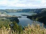
The two crater lakes (Portuguese: Lagoas das Sete Cidades), 500 m (1,500 ft) within the crater, are referred to by the color of the waters: blue, reflecting the sky (Portuguese: Lagoa Azul) and green, reflecting the ground (Portuguese: Lagoa Verde). According to legend, the differently colored lakes were created when a princess and her lover, a young shepherd, had to part from each other. The tears they shed at their farewell became the two lakes, with the water colored like their eyes (see above).
.
Sete Cidades has a school, a church and a small square.
festival.
Piauí
Piauí is one of the states of Brazil, located in the northeastern part of the country.Piauí has the shortest coastline of any of the non-landlocked Brazilian states at 66 km , and the capital, Teresina, is the only state capital in the north east to be located inland...
, Brazil
Brazil
Brazil , officially the Federative Republic of Brazil , is the largest country in South America. It is the world's fifth largest country, both by geographical area and by population with over 192 million people...
, see Sete Cidades, Piauí
Sete Cidades is a civil parish
Parish
A parish is a territorial unit historically under the pastoral care and clerical jurisdiction of one parish priest, who might be assisted in his pastoral duties by a curate or curates - also priests but not the parish priest - from a more or less central parish church with its associated organization...
in the center of the municipality
Municipality
A municipality is essentially an urban administrative division having corporate status and usually powers of self-government. It can also be used to mean the governing body of a municipality. A municipality is a general-purpose administrative subdivision, as opposed to a special-purpose district...
of Ponta Delgada
Ponta Delgada
Ponta Delgada is a city and municipality on the island of São Miguel in the archipelago of the Azores, an autonomous region of Portugal. It includes 44,403 residents in the urban area, and approximately 20,113 inhabitants in the three central parishes that comprise the historical city: São Pedro,...
, that is likewise located in the center of a massive volcanic crater three miles across, also referred to as Sete Cidades. The smallest parish by population (although largest in area), Sete Cidades's population was 858 (2001), in an area of 19.22 km² (its density is 44.6/km²). The parish is widely recognized as an ex-libris of the island of São Miguel
São Miguel Island
São Miguel Island , nicknamed "The Green Island", is the largest and most populous island in the Portuguese Azores archipelago. The island covers and has around 140,000 inhabitants, 45,000 of these people located in the largest city in the archipelago: Ponta Delgada.-History:In 1427, São Miguel...
by locals and members of the Portuguese diaspora.
Latin origins
The region received its geographic nomenclatureNomenclature
Nomenclature is a term that applies to either a list of names or terms, or to the system of principles, procedures and terms related to naming - which is the assigning of a word or phrase to a particular object or property...
from the Latin
Latin
Latin is an Italic language originally spoken in Latium and Ancient Rome. It, along with most European languages, is a descendant of the ancient Proto-Indo-European language. Although it is considered a dead language, a number of scholars and members of the Christian clergy speak it fluently, and...
Insula Septem Civitatum, which means Island of the Seven Tribes or Island of the Seven Peoples (Portuguese: Ilha das Sete Tribos or Ilha dos Sete Povos), but became a historical reference as the Island of the Seven Cities. This comes from classical Latin, probably incorporated into the older traditions of Mediterranean peoples, through the navigators of European antiquity, or the Phoenicians. In Latin, civitas does not signify city, but rather a collectivity of citizens of a determined community.
The first Iberian
Iberian Peninsula
The Iberian Peninsula , sometimes called Iberia, is located in the extreme southwest of Europe and includes the modern-day sovereign states of Spain, Portugal and Andorra, as well as the British Overseas Territory of Gibraltar...
document to refer to Sete Cidades was a Latin chronicle from the city of Porto-Cale (the modern city of Oporto), written in 750 A.D. by a Christian cleric. During this era, the Iberian Kingdom of the Visigoths was in the process of collapse, under pressure from Muslim invasions (which began in 711 A.D.). The Visigoth archbishop fled to Porto-Cale, fearing the assault of the Muslim forces, where he deliberated an escape to the lands in the Western Sea, which sailors insisted existed. In 734, the archbishop, accompanied by six other bishops, their prelates and approximately 5000 faithful, sailed away in a fleet of twenty ships. The chronicle indicated that the fleet arrived at their destination, burned their ships and established seven Christian communities under the reign of the seven religious leaders. Although many prepared to follow, in truth, the archbishop (if he existed) was never heard from again, nor was the route to the mythical lands established.
Although there are no proofs that the island of Seven Cities actually existed, the belief of their existence, some tentative expeditions and brief unconfirmed visual sightings of Atlantic islands, fostered legends during the European Middle Ages
Middle Ages
The Middle Ages is a periodization of European history from the 5th century to the 15th century. The Middle Ages follows the fall of the Western Roman Empire in 476 and precedes the Early Modern Era. It is the middle period of a three-period division of Western history: Classic, Medieval and Modern...
. Consequently many of the Medieval maps and charts that showed the Ocean Sea (the Atlantic Ocean
Atlantic Ocean
The Atlantic Ocean is the second-largest of the world's oceanic divisions. With a total area of about , it covers approximately 20% of the Earth's surface and about 26% of its water surface area...
) identified a island (or islands) represented in different positions or forms. The island of Brasil and/or Antillia (from the Brendan context) and the island of Sete Cidades, were usual geographic references that persisted in the proto-geography of the Atlantic.
With the advent of the Age of Discovery, the visual references and number of voyages of discovery multiplied. One of the more consistent maps presented to King Afonso V of Portugal
Afonso V of Portugal
Afonso V KG , called the African , was the twelfth King of Portugal and the Algarves. His sobriquet refers to his conquests in Northern Africa.-Early life:...
was from the Azorean, Fernão Teles (in 1473). This map showed a long coastline, with various islands, bays and rivers which the author declared were part of the fabled land of Sete Cidades. In reality, the map easily follows the northern coast of Brazil, between Maranhão and Ceará, with the Rio Parnaíba delta. The King, himself, was not totally convinced of the discovery, or did not consider Fernão Teles sufficiently creditable, and that the map only represented a reference that required proofs. Unhappy with the outcome, Teles insisted on the validity of Sete Cidades. He consulted a Genovese
Genoa
Genoa |Ligurian]] Zena ; Latin and, archaically, English Genua) is a city and an important seaport in northern Italy, the capital of the Province of Genoa and of the region of Liguria....
cosmographer Paolo del Pozzo Toscanelli (1398–1492), who declared that Antilla and the island of Sete Cidades existed along the margins of the Atlantic. In his famous letter, Toscanelli placed the mythical lands of Sete Cidades near the Azores:
- "The island of Antillia was discovered by the Portuguese, and now when it is sought it is not found. In this island are people who speak the Spanish tongue, and who in the time of King Roderick are believed to have fled to this island from the barbarians who at the time invaded Spain. Here dwelt an archbishop with six other bishops, each of whom had its own particular city. Wherefore this island is called by many 'seven cities.' These people live most piously in the full enjoyment of all the riches of this time."
In 1476, the Teles's petition of royal authentication was accepted, but no expeditions were sent by the donatario.
Of the better documented expeditions, the Fleming
Flemish people
The Flemings or Flemish are the Dutch-speaking inhabitants of Belgium, where they are mostly found in the northern region of Flanders. They are one of two principal cultural-linguistic groups in Belgium, the other being the French-speaking Walloons...
Ferdinand van Olm (also known in Azorean history as Fernando de Ulmo or Fernão Dulmo) captained an expedition to re-discover the lost kingdoms of Sete Cidades. Ironically, Fernando de Ulmo was then married to one of the daughters of Fernão Teles and lived on one of the islands of the Azores when, in 1486, he received authorization from King João II of Portugal to begin his expedition. In partnership with Afonso do Estreito
João Afonso do Estreito
João Afonso do Estreito, an ambitious sailor from Funchal, Madeira, was a co-partner in the Dulmo-Estreito expedition of 1487, a failed pre-Columbian voyage to the Americas....
, a Madeirense
Madeira
Madeira is a Portuguese archipelago that lies between and , just under 400 km north of Tenerife, Canary Islands, in the north Atlantic Ocean and an outermost region of the European Union...
, he organized his voyage, with the co-financing of the Royal Court, in order to conquer and subjugate the islands. Unfortunately, Fernão Dulmo did not have better luck, but ultimately, around the 17th Century, did organize an expedition to the northwest of Terceira, where an unknown island had been spotted.
Settlement
The colonization of Sete Cidades developed after the property owner, Dr. José Bettencourt, who was the principal benefactor of the lands within the crater, made tracts available for settlement. These lands were rented to farmers and other colleagues, who then cultivated the limited tracts and paid monthly stipends for their use. For a long time, this limited the number of inhabitants living within the caldera.Physical geography
The Sete Cidades volcano it situated on the extreme western portion of the island of São Miguel occupying an area of approximately 110 km², and refers to a polygenetic volcanoVolcano
2. Bedrock3. Conduit 4. Base5. Sill6. Dike7. Layers of ash emitted by the volcano8. Flank| 9. Layers of lava emitted by the volcano10. Throat11. Parasitic cone12. Lava flow13. Vent14. Crater15...
(Sete Cidades Massif) and caldera
Caldera
A caldera is a cauldron-like volcanic feature usually formed by the collapse of land following a volcanic eruption, such as the one at Yellowstone National Park in the US. They are sometimes confused with volcanic craters...
. Its subaerial volume, of about 70 km³, has grown at an estimated rate of 0.02-0.03 km³ per century, beginning more than 210,000 years ago. Presently, the interior of the structure is occupied by diverse volcanic structures and four lakes. It is almost ciruclur caldera (5 km in diameter and up to 400 metre high walls) formed through three phases of eruptions. The first phase occurred 36,000 years ago, and ceased with the collapse of the principal volcano. A secondary phase began around 29,000 years ago and was responsible for the collapse of the northwest portion of the primitive caldera. Around 16,000 years ago the last phase, marked by the collapse of the northern and northeastern portions of the crater occurred. The Sete Cidades Volcano has experienced 17 intra-caldera eruptions within the last 5000 years, which makes it the most active in the archipelago. The intra-calderan activity has been essentially marked by Trachyte
Trachyte
Trachyte is an igneous volcanic rock with an aphanitic to porphyritic texture. The mineral assemblage consists of essential alkali feldspar; relatively minor plagioclase and quartz or a feldspathoid such as nepheline may also be present....
sub-Plinian and Plinian eruptions, with some having hydromagmatic characteristics. The last intra-calderan eruption occurred approximately 500 years A.D., resulting in the creation of the Caldeira Seca cone. At the base of the caldera, there exist six Holocene
Holocene
The Holocene is a geological epoch which began at the end of the Pleistocene and continues to the present. The Holocene is part of the Quaternary period. Its name comes from the Greek words and , meaning "entirely recent"...
era pyroclastic cones. Further, a large group of pleistocene
Pleistocene
The Pleistocene is the epoch from 2,588,000 to 11,700 years BP that spans the world's recent period of repeated glaciations. The name pleistocene is derived from the Greek and ....
post-caldera trachytic lava dome
Lava dome
|250px|thumb|right|Image of the [[rhyolitic]] lava dome of [[Chaitén Volcano]] during its 2008–2009 eruption.In volcanology, a lava dome is a roughly circular mound-shaped protrusion resulting from the slow extrusion of viscous lava from a volcano...
s, lava flows, and pyroclastic-flow deposits have been discovered on the northwestern flanks of the massif.
Along historical time eruptions have generally been basaltic in quality, with effusive characteristics that were less explosive, but generally Hawaiian or Stromblian in nature, occurring along the flanks of the crater and conditioned by regional and radial faults. Unlike Furnas
Furnas
Furnas is a civil parish in the municipality of Povoação on the island of São Miguel in the Azores. The population in 2001 was 1,541, its density is 44.76/km² and the area is 34.43 km². The parish is one of the largest in the island and in the Azores...
, Sete Cidades has no active fumarole, and most secondary manifestations occur in the submarine vents off the coast of Ponta da Ferraria and the coast of Mosteiros, as well as zones of natural degasification.
The most recent historical eruption dates back to the 15th Century. Other eruptions have occurred within the caldera and from submarine vents along the western coast of the island; there have been four Strombolian eruption
Strombolian eruption
Strombolian eruptions are relatively low-level volcanic eruptions, named after the Italian volcano Stromboli, where such eruptions consist of ejection of incandescent cinder, lapilli and lava bombs to altitudes of tens to hundreds of meters...
s and three Surtseyan eruption
Surtseyan eruption
A Surtseyan eruption is a type of volcanic eruption that takes place in shallow seas or lakes. It is named after the island of Surtsey off the southern coast of Iceland....
s in occupied history within a short distance of the shoreline.
The two crater lakes (Portuguese: Lagoas das Sete Cidades), 500 m (1,500 ft) within the crater, are referred to by the color of the waters: blue, reflecting the sky (Portuguese: Lagoa Azul) and green, reflecting the ground (Portuguese: Lagoa Verde). According to legend, the differently colored lakes were created when a princess and her lover, a young shepherd, had to part from each other. The tears they shed at their farewell became the two lakes, with the water colored like their eyes (see above).
Human geography
The urbanized portion of the parish, the village of Sete Cidades, is located in the southwest portion of the crater within the Cumierias da Bretanha and extends from the Blue Lake north to south. Farmland, mostly pastures, are located around the village, and confined to the portions south of the Blue Lake. The remainder of the crater is forested, although the southeastern portion also has some grasslands. A bridge links Sete Cidades to access to Ponta Delgada, and a bridge divides the two lakes. In the western end of the crater, in an area of open parklands, a tunnel has been constructed that links the crater to the village of MosteirosMosteiros (Ponta Delgada)
Mosteiros is a civil parish in the municipality of Ponta Delgada in the Azores. The population in 2001 was 1196, its density is 130/km² and the area is 9.2 km². It is located in the northwestern part of the island of São Miguel and is connected by roads to Ponta Delgada in the south and...
.
Sete Cidades has a school, a church and a small square.
Culture
Since 2006, Sete Cidades hosts the Green Trippin Camp, an increasingly popular tranceTrance music
Trance is a genre of electronic dance music that developed in the 1990s.:251 It is generally characterized by a tempo of between 125 and 150 bpm,:252 repeating melodic synthesizer phrases, and a musical form that builds up and breaks down throughout a track...
festival.