

Scottish place names in New Zealand
Encyclopedia
This is a list of placenames in Scotland
which have subsequently been applied to parts of New Zealand
by Scottish emigrants or explorers.
The South Island also contains the Strath-Taieri and the Ben Ohau Range
of mountains, both combining Scots Gaelic and Māori
origins. Invercargill
has the appearance of a Scottish name, since it combines the Scottish prefix "Inver" (Inbhir), meaning a river's mouth, with "Cargill", the name of a Scottish official. (Invercargill's main streets are named after Scottish rivers: Dee, Tay, Spey, Esk, Don, Doon, Clyde, etc.). Inchbonnie
is a hybrid of Lowland Scots
and Scottish Gaelic
Scotland
Scotland is a country that is part of the United Kingdom. Occupying the northern third of the island of Great Britain, it shares a border with England to the south and is bounded by the North Sea to the east, the Atlantic Ocean to the north and west, and the North Channel and Irish Sea to the...
which have subsequently been applied to parts of New Zealand
New Zealand
New Zealand is an island country in the south-western Pacific Ocean comprising two main landmasses and numerous smaller islands. The country is situated some east of Australia across the Tasman Sea, and roughly south of the Pacific island nations of New Caledonia, Fiji, and Tonga...
by Scottish emigrants or explorers.
The South Island also contains the Strath-Taieri and the Ben Ohau Range
Ben Ohau Range
Ben Ohau Range is a mountain range in Canterbury Region, South Island, New Zealand. It lies west of Lake Pukaki, at .- External links :*...
of mountains, both combining Scots Gaelic and Māori
Maori language
Māori or te reo Māori , commonly te reo , is the language of the indigenous population of New Zealand, the Māori. It has the status of an official language in New Zealand...
origins. Invercargill
Invercargill
Invercargill is the southernmost and westernmost city in New Zealand, and one of the southernmost cities in the world. It is the commercial centre of the Southland region. It lies in the heart of the wide expanse of the Southland Plains on the Oreti or New River some 18 km north of Bluff,...
has the appearance of a Scottish name, since it combines the Scottish prefix "Inver" (Inbhir), meaning a river's mouth, with "Cargill", the name of a Scottish official. (Invercargill's main streets are named after Scottish rivers: Dee, Tay, Spey, Esk, Don, Doon, Clyde, etc.). Inchbonnie
Inchbonnie
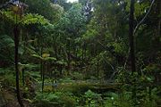
Inchbonnie is a rural locality in the West Coast region of New Zealand's South Island."Inchbonnie" is a hybrid of Lowland Scots, bonnie meaning "pretty" and Scottish Gaelic innis meaning island, often anglicised as "Inch", as in Inchkeith or Inchkenneth in Scotland.It allegedly receives 6 m of rain...
is a hybrid of Lowland Scots
Scots language
Scots is the Germanic language variety spoken in Lowland Scotland and parts of Ulster . It is sometimes called Lowland Scots to distinguish it from Scottish Gaelic, the Celtic language variety spoken in most of the western Highlands and in the Hebrides.Since there are no universally accepted...
and Scottish Gaelic
North Island
- Suburbs of Auckland (incl. North Shore City, Waitakere, Manukau)
- Ardmore
- Ardmore, New Zealand + Ardmore Airport
- Balmoral, New ZealandBalmoral, New ZealandBalmoral is a suburb of Auckland, New Zealand that is bordered by Mount Eden, Epsom, Mount Roskill and Sandringham and is located approximately 5 km from the centre of Auckland. It was named around the turn of the 20th century and derives its name from Balmoral Castle, the Scottish country...
- Glen Eden, New ZealandGlen Eden, New ZealandGlen Eden is a suburb of Auckland city, in New Zealand. The suburb is in the Waitakere Ward, one of the thirteen administrative areas of Auckland and is governed by the Auckland Council....
- Glen Innes, New ZealandGlen Innes, New ZealandGlen Innes is a suburb located in Auckland, New Zealand. It is located nine kilometres to the east of the city centre, close to the waters of the Tamaki River.The main streets in Glen Innes are Line Road and Apirana Avenue, which meet at a roundabout...
- Glendene, New ZealandGlendene, New ZealandGlendene is an Auckland suburb. It is under the local governance of the Waitakere City Council.Glendene School and community arts college is a special needs school in the north-east of England in a village called Easington, County Durham....
- Glendowie, New ZealandGlendowie, New ZealandGlendowie is a suburb in Auckland, New Zealand. Glendowie is under the local governance of the Auckland City Council.According to the 2001 census, Glendowie has a population of 3,825.-Location:...
- Glenfield, New ZealandGlenfield, New ZealandGlenfield is a suburb of North Shore, one of several cities in the Auckland metropolitan area in northern New Zealand. It is located to the north of the Waitemata Harbour, nine kilometres northwest of the Auckland city centre....
- Henderson, New ZealandHenderson, New ZealandHenderson is a major suburb of Auckland, in the North Island of New Zealand. It is located 13 kilometres to the west of Auckland city centre, and two kilometres to the west of the Whau River, a southwestern arm of the Waitemata Harbour.-Description:...
- Kirkbride, New Zealand (MangereMangereMāngere is one of the larger suburbs in South Auckland, in northern New Zealand.The suburb is located on flat land at the northeastern shore of the Manukau Harbour, to the northwest of the centre of Manukau city and 15 kilometres south of Auckland city centre...
) - Murrays BayMurrays BayMurrays Bay is a small suburb in Auckland's East Coast Bays region. The suburb is roughly the same size as Rothesay Bay, the suburb to the immediate north. It is primarily a residential area but does have a community centre, restaurant and takeaway...
- Rothesay BayRothesay Bay- to the east - to the south - to the south-west - to the north-west Browns BayHauraki GulfMurrays BayPinehillNorthcrossRothesay Bay is a small suburb in North Shore City's East Coast Bays region...
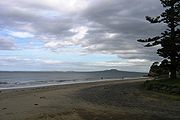
- Cape CampbellCape CampbellCape Campbell , Te Karaka in Māori language, is located in Marlborough, New Zealand, on the northeastern coast of the South Island. It lies at the southern end of Clifford Bay, 15 km northeast of Ward, and 42 km southeast of Blenheim....
- Cape EgmontCape EgmontCape Egmont is the westernmost point of Taranaki, on the west coast of New Zealand's North Island. It is located close to the volcanic cone of Mount Taranaki or Mount Egmont....
- Dalmeny Corner (Coromandel)
- Eskdale, New Zealand (Hawkes Bay)
- Firth of ThamesFirth of ThamesThe Firth of Thames is a large bay located in the north of the North Island of New Zealand. It is the firth of the rivers Waihou and Piako, the former of which was formerly named the Thames River, and the town of Thames lies on its southeastern coast....
(from the Scottish word "firthFirthFirth is the word in the Lowland Scots language and in English used to denote various coastal waters in Scotland and England. In mainland Scotland it is used to describe a large sea bay, or even a strait. In the Northern Isles it more usually refers to a smaller inlet...
") - Frasertown, New Zealand
- Gisborne suburbs
- Elgin, New Zealand
- HamiltonHamilton, New ZealandHamilton is the centre of New Zealand's fourth largest urban area, and Hamilton City is the country's fourth largest territorial authority. Hamilton is in the Waikato Region of the North Island, approximately south of Auckland...
- Callum BraeCallum BraeCallum Brae is a suburb in north-eastern Hamilton in New Zealand....
, a Hamilton suburb ("Callum McDougal" + "Brae" - a hill)
- Callum Brae
- Glenbrook, New ZealandGlenbrook, New ZealandGlenbrook is a rural and industrial area in the Franklin district of New Zealand.The industrial site, that of New Zealand's major steel mill, New Zealand Steel, is not located close to any towns - the surrounding countryside is occupied by huge farms...
(Waikato) - Glendowie, New ZealandGlendowie, New ZealandGlendowie is a suburb in Auckland, New Zealand. Glendowie is under the local governance of the Auckland City Council.According to the 2001 census, Glendowie has a population of 3,825.-Location:...
- HuntlyHuntly, New ZealandHuntly is a town in the Waikato region of the North Island of New Zealand. It is on State Highway 1, 93 kilometres south of Auckland and 35 kilometres north of Hamilton. It is situated on the North Island Main Trunk Railway and straddles the Waikato River.Huntly was called Rahui Pokeka when...
- KilbirnieKilbirnie, New ZealandKilbirnie , a suburb of Wellington in New Zealand, lies 3 kilometers to the south-east of the city centre. Travellers can reach Kilbirnie from the Wellington central business district either via the Mount Victoria Tunnel and Hataitai; over Mount Victoria; or around the coast...
- Kinloch, New ZealandKinloch, New ZealandKinloch is a small but growing town on the most northerly bay of Lake Taupo, northwest of Taupo on the North Island Volcanic Plateau of New Zealand. It is in the Waikato Region....
- LaingholmLaingholmLaingholm is a small community situated in the Waitakere Ranges west of Auckland, in one of the fastest growing regions in New Zealand. It is part of Waitakere City, New Zealand's first "eco-city"....
- Mackenzie Bay (on Rangitoto
- Napier, New ZealandNapier, New ZealandNapier is a New Zealand city with a seaport, located in Hawke's Bay on the eastern coast of the North Island. The population of Napier is about About 18 kilometres south of Napier is the inland city of Hastings. These two neighboring cities are often called "The Twin Cities" or "The Bay Cities"...
- Waverley, New ZealandWaverley, New ZealandWaverley is a small town located in the South Taranaki District in New Zealand. It is 44 km northwest of Wanganui. Patea is 17 km to the west, and Waitotara is 10 km to the southeast...
(Taranaki, after Walter ScottWalter ScottSir Walter Scott, 1st Baronet was a Scottish historical novelist, playwright, and poet, popular throughout much of the world during his time....
's hero "WaverleyWaverleyWaverley is the name of several different things:*Waverley , a novel by Sir Walter Scott**The Waverley Novels, the series of which Waverley was the first**The Waverley Overture, a work by Hector Berlioz inspired by Scott's novel...
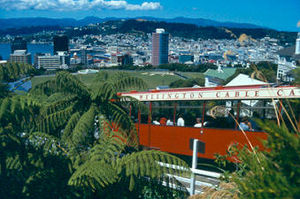
") - Suburbs of Wellington
- Kelburn, New ZealandKelburn, New Zealandthumb|300px|Panorama of Wellington including the Kelburn cable car.Kelburn is an inner suburb of Wellington, New Zealand. It is located on the hills to the west of the Central Business District.-Features of Kelburn:...
, named for David Boyle, 7th Earl of GlasgowDavid Boyle, 7th Earl of GlasgowDavid Boyle, 7th Earl of Glasgow, GCMG was a Governor of New Zealand.-Royal Navy:Boyle served with the Royal Navy during the Crimean and Second Opium Wars... - Kilbirnie, New ZealandKilbirnie, New ZealandKilbirnie , a suburb of Wellington in New Zealand, lies 3 kilometers to the south-east of the city centre. Travellers can reach Kilbirnie from the Wellington central business district either via the Mount Victoria Tunnel and Hataitai; over Mount Victoria; or around the coast...
- SeatounSeatounSeatoun is an eastern suburb of Wellington, the capital city of New Zealand. It is on the east coast of the Miramar Peninsula, close to the entrance to Wellington Harbour , some seven kilometres southeast of the CBD...
- Kelburn, New Zealand
South Island
- Athol, New ZealandAthol, New ZealandAthol is a small town in Southland, New Zealand. It is located 55 km south of Queenstown, half way between Lumsden and Kingston. The name of Athol, is rumored to be derived from either Harry Athol, the owner of the township's first public house, or after Athol, Perthshire, Scotland, the home...
- Aviemore, New Zealand
- Avon River, Christchurch - named by the Deans Brothers.
- BalcluthaBalclutha, New ZealandBalclutha is a town in Otago, it lies towards the end of the Clutha River on the east coast of the South Island of New Zealand. It is about halfway between Dunedin and Invercargill on the Main South Line railway, State Highway 1 and the Southern Scenic Route...
- from the Gaelic for 'Clydetown' (Baile Chluaidh) - Lake BenmoreLake BenmoreLake Benmore is a lake located in the South Island of New Zealand. It was artificially created in the 1960s by construction of Benmore Dam. The lake covers an area of approximately 75 km²...
(Beinn Mor) - BalfourBalfour, New ZealandBalfour is a small town located in the Southland Region of New Zealand. According to the 2001 New Zealand Census of Population and Dwellings, it has a usually resident population of 135, unchanged from the previous census in 1996....
- Bannockburn, New ZealandBannockburn, New ZealandBannockburn is a small historic gold mining town located outside of Cromwell in Central Otago, New Zealand.The area was first made known as a rich alluvial gold field and was mined extensively in the 1860s....
- Blackmount, New Zealand
- Ben McLeod
- Benmore Range (mountains)
- Ben Nevis, New Zealand
- Chatto Creek
- Suburbs of Christchurch
- Burnside, CanterburyBurnside, CanterburyBurnside is a suburb of Christchurch, New Zealand, located southeast of Christchurch International Airport. As with most suburbs in Christchurch, it has no defined boundaries and is a general area.-History:...
(from "Burn", the Scots word for a small riverhttp://library.christchurch.org.nz/Heritage/LocalHistory/Fendalton/Bryndwr_Burnside.asp) - Riccarton, New ZealandRiccarton, New ZealandRiccarton is a suburb of Christchurch. It is due west of the city centre, separated from it by Hagley Park. Upper Riccarton is to the west of Riccarton.-History:...
- Burnside, Canterbury
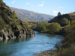
- Clutha RiverClutha RiverThe Clutha River / Mata-Au is the second longest river in New Zealand flowing south-southeast through Central and South Otago from Lake Wanaka in the Southern Alps to the Pacific Ocean, south west of Dunedin. It is the highest volume river in New Zealand, and the swiftest, with a catchment of ,...
(from "Cluaidh", Scots Gaelic for "Clyde") - ClydeClyde, New ZealandClyde is a small town in Central Otago, New Zealand with a population of 918 in 2006. It is located on the Clutha River, between Cromwell and Alexandra....
- CheviotCheviot, New ZealandCheviot is a town in the Hurunui District of north Canterbury, on the east coast of the South Island of New Zealand. It is on the Main North Line railway and State Highway 1 approximately north of Christchurch. It was originally called Mackenzie after politician John McKenzie, who was closely...
- CraigieburnCraigieburn, New ZealandCraigieburn is the name of several geographic features in northwest Canterbury, in New Zealand's South Island.The Craigieburn Range of mountains is located on the south banks of the Waimakariri River, south of Arthur's Pass. The Craigieburn Valley ski area is world renowned, and it located on its...
- Denniston (DennistounDennistounDennistoun is a district of the city of Glasgow, Scotland. It is situated north of the River Clyde in the east end of the city. It is made up of a number of smaller districts - Milnbank to the north, 'The Drives' in the centre of the area and Bellgrove below Duke Street to the south. In a 2004...
) - Dumbarton
- Dunback, New Zealand
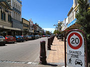
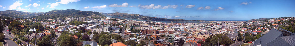
- DunedinDunedinDunedin is the second-largest city in the South Island of New Zealand, and the principal city of the Otago Region. It is considered to be one of the four main urban centres of New Zealand for historic, cultural, and geographic reasons. Dunedin was the largest city by territorial land area until...
, from Dun Eideann, Scottish Gaelic for Edinburgh, and its suburbs listed below. Many of the city's central streets (such as Princes StreetPrinces Street, DunedinPrinces Street is a major street in Dunedin, the second largest city in the South Island of New Zealand. It runs south-southwest for two kilometres from The Octagon in the city centre to the Oval sports ground, close to the city's Southern Cemetery...
and Moray PlaceMoray Place, DunedinMoray Place is an octagonal street which surrounds the city centre of Dunedin, Otago, New Zealand. The street is intersected by Stuart Street , Princes Street and George Street...
) are named after equivalent streets in Edinburgh.- Abbotsford
- Belleknowes
- BurnsideBurnside, OtagoBurnside is a mainly industrial suburb of the New Zealand city of Dunedin. It is located at the mouth of a long valley, the Kaikorai Valley, through which flows the Kaikorai Stream. This valley stretches to the northeast for . Burnside is to the southwest of the city centre, close to eastern end...
- Calton Hill
- CorstorphineCorstorphine, New ZealandCorstorphine is a suburb of southwest Dunedin in the South Island of New Zealand. It is located on the slopes of Calton Hill - a spur of Forbury Hill - between Caversham Valley and the Pacific Ocean...
- Dalmore
- Glenleith
- Macandrew Bay
- MaryhillMaryhill, New ZealandMaryhill is a residential suburb of the New Zealand city of Dunedin. It is located on a ridge to the southwest of the central city between the suburbs of Mornington, Kenmure, and Caversham. The smaller suburb of Balaclava lies immediately to its west. Maryhill takes its name from a district in the...
- MusselburghMusselburgh, New ZealandMusselburgh is a residential suburb of the New Zealand city of Dunedin. It is located in the southeast of the city's urban area, southeast of the city's centre, and at the narrowest point of the isthmus which joins Otago Peninsula to the rest of the South Island . The suburb takes its name from...
- PortobelloPortobello, New ZealandPortobello is a village beside the Otago Harbour halfway along the Otago Peninsula in Dunedin City, New Zealand. It lies at the foot of a small peninsula between Portobello Bay and Latham Bay....
- Roslyn
- Saint KildaSaint Kilda, New ZealandSt Kilda is a suburb of the New Zealand city of Dunedin. A densely populated residential suburb, it lies on the southern part of the city's central plain, to the southwest of the head of the harbour and immediately north of Ocean Beach, parts of which are within the suburb and form its major...
- Saint ClairSaint Clair, New ZealandSt Clair is a leafy residential suburb of the New Zealand city of Dunedin. It is located on the Pacific Ocean coast five kilometres from the city centre on the southwesternmost part of the coastal plain which makes up the southern part of the urban area, and also climbs the slopes of Forbury Hill...
- WaverleyWaverley, OtagoWaverley is a suburb of the New Zealand city of Dunedin. It is located at the start of the Otago Peninsula, southeast of the city centre, on a rise overlooking the Otago Harbour to the north....
- DrummondDrummond, New ZealandDrummond is a small town in Southland, New Zealand. It is 35 kilometres north of Invercargill and 18 kilometres west of Winton.The town has one golf course, a primary school called Central Southland Rural Primary School and a population of about 250....
- Duncan Bay
- DuntroonDuntroon, New ZealandDuntroon is a small farming town in the Waitaki District of New Zealand's South Island. Although traditionally considered a North Otago town, it is presently officially located within the farthest southern reaches of Canterbury...
- Eglinton RiverEglinton RiverThe Eglinton River is located in the region of Southland in the southwest of New Zealand. It flows through Fiordland National Park for 50 kilometres...
- Eyre Mountains
- Lake DunstanLake DunstanLake Dunstan is a man-made lake and reservoir in the South Island of New Zealand.The lake was formed on the Clutha River as a result of the construction of the Clyde Dam, filling in four controlled stages beginning in April 1992 and completed the next year...
- Dunstan Range (mountains)
- EttrickEttrick, New ZealandEttrick is a small town in inland Otago, in the South Island of New Zealand.-Geography:Ettrick is located on the Clutha River and State Highway 8 south of Roxburgh and five kilometres northwest of the small settlement of Millers Flat...
- Fairlie, New ZealandFairlie, New ZealandFairlieUrban AreaPopulation:723Extent:Territorial AuthorityName:Mackenzie District CouncilPopulation:Mayor:Website:Extent:Regional councilName:Environment Canterbury...
- Forsyth Island, New Zealand
- FortroseFortrose, New ZealandFortrose is a locality on the southernmost coast of the South Island of New Zealand in the Southland region. It is situated on Toetoes Bay at the mouth of the Mataura River, and is on the far western edge of the Catlins...
- Galloway, New Zealand
- Garvie Mountains
- GlenavyGlenavy, New ZealandGlenavy is a locality in the South Island of New Zealand. It is located at the southern extreme of the Canterbury region on the alluvial fan of the Waitaki River, three kilometres from the river's outflow into the Pacific Ocean....
- Glenburn, New Zealand
- Glencoe, New ZealandGlencoe, New ZealandGlencoe is a locality in the central Southland Region of New Zealand's South Island. Named after Glen Coe in Scotland, it is situated in the Hokonui Hills on the route of State Highway 96 as it travels between Hedgehope and Waitane...
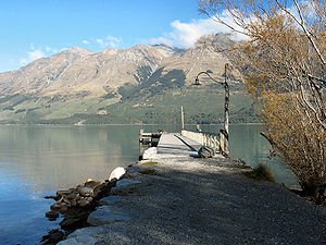
- GlenorchyGlenorchy, New ZealandGlenorchy is a small settlement nestled in spectacular scenery at the northern end of Lake Wakatipu in New Zealand's south Island. It is approximately 45 kilometres by road or boat from Queenstown, the nearest large town....
- Glentanner
- GlentunnelGlentunnelGlentunnel is a small village in the Selwyn District of the Canterbury region of New Zealand's South Island. It is officially recognised as a "populated area less than a town". The 2001 New Zealand Census of Population and Dwellings gave Glentunnel's population as 129...
- The Grampians (mountains)
- Inch CluthaInch CluthaInch Clutha is a large, flat island sitting in the delta between the Matau and Koau branches of the Clutha River, downstream from the town of Balclutha in the South Island of New Zealand...
(Meaning Clyde Island) - KelsoKelso, New ZealandKelso was a small settlement in Otago, New Zealand, located ten kilometres north of Tapanui on the Kelso River, close to its junction with the larger Pomahaka River...
- Kinloch
- Kirkliston Range
- Kyeburn, New Zealand (=River/stream of the cows)
- Lake AviemoreLake AviemoreLake Aviemore or Mahi Tikumu is a man-made lake in New Zealand's South Island, part of the Waitaki hydroelectric scheme. Immediately upstream is Lake Benmore and downstream Lake Waitaki...
- Lake BenmoreLake BenmoreLake Benmore is a lake located in the South Island of New Zealand. It was artificially created in the 1960s by construction of Benmore Dam. The lake covers an area of approximately 75 km²...
- Lake ForsythLake ForsythLake Forsyth is a lake in the Canterbury region of New Zealand.It is fed by the Takiritawai River, a short arm of the Okuti River, and exits via a gravel bank into the sea in the vicinity of the small community of Birdling's Flat.State Highway 75 leading to Akaroa and part of the Little River Rail...
- Lake InnesLake InnesLake Innes is a lake in the South Island of New Zealand.The lake is part of the Aan River....
- Lammerlaw Range (mountains)
- Lammermoor Range (mountains)
- Lauder, New Zealand
- Lochmara Bay (Queen Charlotte SoundQueen Charlotte Sound, New ZealandQueen Charlotte Sound is the easternmost of the main sounds of the Marlborough Sounds, in New Zealand's South Island. It is, like the other sounds, a drowned river valley , and like the majority of its neighbours it runs southwest to northeast before joining Cook Strait.The town of Picton, the...
- Loch na Mara = loch of the sea) - Lochiel, New Zealand
- LuggateLuggateLuggate is a small township in the South Island of New Zealand. It is located on State Highway 6 between Wanaka and Cromwell, near the junction with State Highway 8A, approximately 15 km from the Wanaka township, just past Wanaka Airport....
- LumsdenLumsden, New ZealandLumsden is a town in Southland, New Zealand. Lying in a gap in the surrounding hills, it is the location of a major junction halfway along the north-south road from Queenstown to Invercargill, where it is crossed by the east-west road from Gore to Te Anau. The town had a population of 453 as of the...
- Mackenzie BasinMackenzie BasinThe Mackenzie Basin , is an elliptical intermontane basin, located in the Mackenzie and Waitaki Districts, near the centre of the South Island of New Zealand. It is the largest such basin in New Zealand...
(James Mckenzie) - Maclennan, New ZealandMaclennan, New ZealandMaclennan is a small settlement in The Catlins, an area of the southern South Island of New Zealand. It is located 20 kilometres southwest of Owaka. From 1915 until its closure on 27 February 1971, the Catlins River Branch railway passed through the village, and the station building and goods shed...
- Maclennan Range (Catlins)
- Macraes FlatMacraes FlatMacraes Flat is a town in the Waitaki District in Otago, New Zealand. It is known as a mining town, with a long history of gold extraction. It is near Macraes Mine owned by OceanaGold Corporation. The town sits 55 km north of Dunedin in New Zealand's South Island....
- Methven, New ZealandMethven, New ZealandMethven is a small town in the Canterbury region of the South Island of New Zealand. It is located near the western edge of the Canterbury Plains, 35 kilometres north of Ashburton. It was originally the railhead of a short branch railway off the Main South Line...
- Mosgiel
- Mossburn, New Zealand
- Mount Bruce
- Nevis Bluff
- Nevis RiverNevis RiverThe Nevis River is located in Otago, New Zealand. It flows north for 40 kilometres through rough country before meeting the Kawarau River, of which it is a tributary. A prominent rock outcrop close to this junction is known as the Nevis Bluff....
- RanfurlyRanfurly, New ZealandRanfurly is the largest settlement in the Maniototo district of Otago, New Zealand. Located 110 kilometres north of Dunedin, it lies in dry rough country at a moderately high altitude close to a small tributary of the Taieri River. It is a service town for the local farming community...
- Renwick, New ZealandRenwick, New ZealandRenwick is a small town in Marlborough, New Zealand, close to the south bank of the Wairau River. It is located on State Highway 6, 12 km west of Blenheim. Havelock is 31 km north...
- RoxburghRoxburgh, New ZealandRoxburgh is a small New Zealand town of about 600 people in Central Otago. It is in Teviot Valley on the banks of the Clutha River, 40 km south of Alexandra in the South Island. State Highway 8, which links Central Otago with Dunedin city, passes through the town...
- Lake RoxburghLake RoxburghLake Roxburgh is an artificial lake, created by the Roxburgh Dam, the earliest of the large hydroelectric projects in the southern South Island of New Zealand. It lies on the Clutha River, some 160 kilometres from Dunedin. It covers an area of some 6 km², and extends for nearly 30 kilometres...
- Saint Bathans, New ZealandSaint Bathans, New ZealandThe former gold and coal mining town of St Bathans, formerly named Dunstan Creek, lies deep in the heart of the Maniototo in New Zealand's Otago region. Mining has long ceased, and it is a tranquil holiday retreat. The preservation of many of its historic buildings makes it one of the region's more...
(Abbey St Bathans) - Soutra Hill, New Zealand
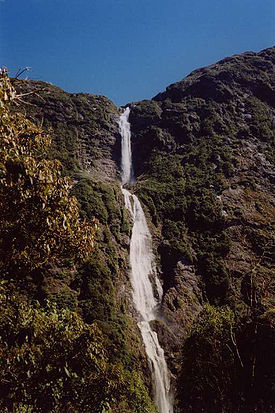
- Sutherland FallsSutherland FallsSutherland Falls is a waterfall near Milford Sound in New Zealand's South Island. At 580 metres the falls were long believed to be the tallest waterfall in New Zealand...
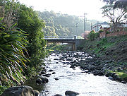
(waterfall) - Water of LeithWater of Leith, New ZealandThe Water of Leith , is a small river in the South Island of New Zealand.It rises to the north of the city of Dunedin, flowing for 14 kilometres southeast through the northern part of the city and the campus of the University of Otago before reaching the Otago Harbour...
(river) - Wedderburn, New ZealandWedderburn, New ZealandWedderburn is a community in Central Otago, New Zealand. It is located 15 kilometres northwest of Ranfurly, and was at one time close to the centre of a thriving gold and coal mining area...
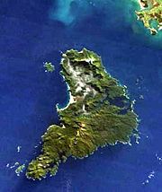
Stewart Island (Rakiura)
- Stewart Island
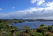
- ObanOban, New ZealandOban is the principal settlement on Stewart Island/Rakiura, the southernmost inhabited island of the New Zealand archipelago. Oban is located on Halfmoon Bay , on Paterson Inlet...
, largest settlement in Stewart Island - Paterson InletPaterson Inlet, New ZealandPaterson Inlet is a large natural harbour in the eastern coast of Stewart Island/Rakiura, New Zealand, much of which is unspoilt forest.This region was first inhabited by the Māori, who settled at a locale known as The Neck, which is a long peninsula that extends across the mouth of the inlet from...
- Ulva IslandUlva Island, New ZealandUlva Island is a small island about long lying within Paterson Inlet, which is part of Stewart Island/Rakiura in New Zealand. It has an area of about , the majority of which is public land...
- The SnaresThe SnaresSnares Islands/Tini Heke is a small island group situated approximately 200 kilometres south of New Zealand's South Island and to the south-south-west of Stewart Island/Rakiura. The Snares consist of the main island North East Island and the smaller Broughton Island as well as the somewhat...
(not a Scottish name)- Broughton IslandBroughton Island, New ZealandBroughton Island is the second largest island of The Snares, at just off the South Promontory of the main island North East Island, which lies approximately south of New Zealand's South Island. The island is some long in SW direction, and the highest elevation is...
- Broughton Island
See also
- Scottish New ZealanderScottish New ZealanderScottish New Zealanders are New Zealanders who are of Scottish ancestry.Scottish migration to New Zealand dates back to the earliest period of European colonisation, with a large proportion of Pākehā New Zealanders being of Scottish descent. However, identification as "British" or "European" New...
- Scottish place names in AustraliaScottish place names in AustraliaThis is a list of placenames in Scotland which have subsequently been applied to parts of Australia by Scottish emigrants or explorers.-Australian Capital Territory:* Campbell * Duntroon* Fraser* Lawson* Macgregor...
- Scottish place names in CanadaScottish place names in CanadaThis is a list of placenames in Scotland which have subsequently been applied to parts of Canada by Scottish emigrants or explorers.For Nova Scotian names in Scottish Gaelic see Canadian communities with Scottish Gaelic speakers and Scottish Gaelic placenames in CanadaNote that, unless otherwise...
- Scottish place names in Sri LankaScottish place names in Sri LankaThis is a list of placenames in Scotland which have subsequently been given to parts of Sri Lanka by Scottish planters. Almost without exception Scottish place names in Sri Lanka occur either in the Hill Country plantations or in Colombo....
- Scottish place names in the United StatesScottish place names in the United StatesThis is a list of names of Scottish origin which have subsequently been applied to parts of the United States by Scottish emigrants or explorers. Unfortunately many of these placenames are now wrongly pronounced in the US e.g...