

Moray Place, Dunedin
Encyclopedia
Dunedin
Dunedin is the second-largest city in the South Island of New Zealand, and the principal city of the Otago Region. It is considered to be one of the four main urban centres of New Zealand for historic, cultural, and geographic reasons. Dunedin was the largest city by territorial land area until...
, Otago
Otago
Otago is a region of New Zealand in the south of the South Island. The region covers an area of approximately making it the country's second largest region. The population of Otago is...
, New Zealand
New Zealand
New Zealand is an island country in the south-western Pacific Ocean comprising two main landmasses and numerous smaller islands. The country is situated some east of Australia across the Tasman Sea, and roughly south of the Pacific island nations of New Caledonia, Fiji, and Tonga...
. The street is intersected by Stuart Street
Stuart Street, Dunedin
Stuart Street is one of the main streets of Dunedin, New Zealand. As with many of Dunedin's streets, it is named after a main street in Edinburgh, Scotland....
(to the east and west), Princes Street
Princes Street, Dunedin
Princes Street is a major street in Dunedin, the second largest city in the South Island of New Zealand. It runs south-southwest for two kilometres from The Octagon in the city centre to the Oval sports ground, close to the city's Southern Cemetery...
(to the south) and George Street
George Street, Dunedin
George Street is the main street of Dunedin, the second largest city in the South Island of New Zealand. It runs for two and a half kilometres north-northeast from The Octagon in the city centre to the foot of Pine Hill. It is straight and undulates gently as it skirts the edge of the hills to its...
(to the north). Like many streets in Dunedin, it is named for a street in the Scottish
Scotland
Scotland is a country that is part of the United Kingdom. Occupying the northern third of the island of Great Britain, it shares a border with England to the south and is bounded by the North Sea to the east, the Atlantic Ocean to the north and west, and the North Channel and Irish Sea to the...
capital Edinburgh
Edinburgh
Edinburgh is the capital city of Scotland, the second largest city in Scotland, and the eighth most populous in the United Kingdom. The City of Edinburgh Council governs one of Scotland's 32 local government council areas. The council area includes urban Edinburgh and a rural area...
(Dunedin itself is the Gaelic name of its Scottish sister city).
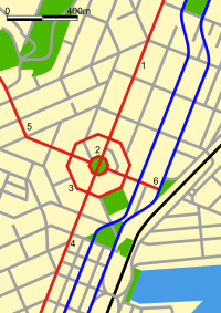
Location and layout
The northeastern quadrant between George Street and Lower Stuart Street is flat, but the other three quadrants slope considerably, especially the southeastern and northwestern quadrants.Many of Dunedin's major inner city buildings are located on Moray Place. These include Dunedin Municipal Chambers, Dunedin Public Library, and the grounds of St. Paul's Anglican Cathedral
St. Paul's Cathedral, Dunedin
St Paul's Cathedral is the mother church of the Anglican Diocese of Dunedin, in New Zealand and the seat of the Bishop of Dunedin.-Location:The Cathedral Church of St Paul occupies a site in the heart of The Octagon near the Dunedin Town Hall and hence Dunedin...
, which lie within the northwestern quadrant between Moray Place and the City Centre (The Octagon
The Octagon, Dunedin
The Octagon is the city centre of Dunedin, in the South Island of New Zealand.-Features:The Octagon is an eight sided plaza bisected by the city's main street, which is called George Street to the northeast and Princes Street to the southwest...
).
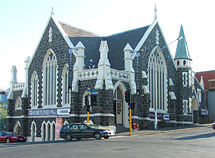
The southwestern quadrant includes the former Dunedin Public Library building (the Carnegie Centre), the Fortune Theatre, and one of the city's main cinemas. This quadrant is regarded as part of the heart of Dunedin's art district, and contains several galleries, one of which is housed in the city's original synagogue
Dunedin Synagogue
The Dunedin Synagogue is an historic synagogue in Dunedin, New Zealand. It is the world's southernmost synagogue.The name can refer both to the historic building, the old Dunedin synagogue, and to the Dunedin Jewish Congregation, Dunedin....
.
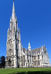
The southeastern quadrant is dominated by First Church, which sits atop the remnants of Bell Hill, the top of which was lowered to allow for First Church's construction. The home and private museum of Thomas Hocken
Thomas Hocken
Thomas Morland Hocken was a prominent New Zealand collector, bibliographer and researcher. He was born in Stamford, Lincolnshire on 14 January 1836, the son of a Wesleyan minister, and educated at Woodhouse Grove School and a school in Newcastle...
were located in this quadrant of Moray Place, and the offices of Taylormade Media are also located here.
The northeastern quadrant is part of Dunedin's central retail precinct.
History
Charles Kettle
Charles Henry Kettle surveyed the city of Dunedin in New Zealand, imposing a bold design on a challenging landscape. He was aiming to create a Romantic effect and incidentally produced the world's steepest street, Baldwin Street....
during the 1840s. An initial obstacle to the development of the city was Bell Hill, a large outcrop situated where the southeastern quadrant of Moray Place now lies. This effectively split the early settlement of Dunedin in two, and for the first few years of settlement, a cutting through the hill was the only land route between the parts of the town town to the north and south. The hill was quarried during the 1850s, providing building material for many of the city's early buildings.
Kettle's initial plan may have been for the entire area within Moray Place to be a public reserve. This did not come to pass, and it was only through Kettle's direct intervention that the central part of the Octagon itself was not built on. As it is, the buildings between Moray Place and The Octagon include many of Dunedin's most prominent structures, and - though it may not have been Kettle's original intention - the concentric octagons of Moray Place and The Octagon are now undeniably the city's centre.
In 1897, a fire station was built on Moray Place, located between the Municipal Chambers and St Paul's Cathedral. It was located here for accessibility to the city, but was moved just 14 years later in 1911 because the new motor engines used on the trucks woke residents and caused complaints as they went through the town on callouts. A larger building was also needed to house new equipment. The original building has long since been demolished and a car park now exists on that site.
External links
- The Octagon & Moray Place history Dunedin Council City