

San Gabriel Pastoral Region
Encyclopedia
The San Gabriel Pastoral Region is a pastoral region of the Archdiocese of Los Angeles
in the Roman Catholic Church
. It covers East Los Angeles
through the San Gabriel
and Pomona
valleys. The current regional auxiliary bishop
is Bishop Gabino Zavala
. The region has 67 parishes, 13 high schools, many elementary schools, 3 hospitals, 2 cemeteries, and 1 Spanish Mission
.
List of schools in the Roman Catholic Archdiocese of Los Angeles
Roman Catholic Archdiocese of Los Angeles
The Archdiocese of Los Angeles is an archdiocese of the Roman Catholic Church in the U.S. state of California. Headquartered in Los Angeles, the archdiocese comprises the California counties of Los Angeles, Santa Barbara and Ventura. The diocesan cathedral is the Cathedral of Our Lady of the...
in the Roman Catholic Church
Roman Catholic Church
The Catholic Church, also known as the Roman Catholic Church, is the world's largest Christian church, with over a billion members. Led by the Pope, it defines its mission as spreading the gospel of Jesus Christ, administering the sacraments and exercising charity...
. It covers East Los Angeles
East Los Angeles (region)
East Los Angeles is the portion of the City of Los Angeles that lies east of Downtown Los Angeles, the Los Angeles River and the unincorporated areas of Lincoln Heights, west of the San Gabriel Valley, East Los Angeles and City Terrace, south of Cypress Park, and north of Vernon, California and...
through the San Gabriel
San Gabriel Valley
The San Gabriel Valley is one of the principal valleys of Southern California, United States. It lies to the east of Los Angeles, to the north of the Puente Hills, to the south of the San Gabriel Mountains, and west of the Inland Empire. It derives its name from the San Gabriel River that flows...
and Pomona
Pomona Valley
The Pomona Valley, located between the San Gabriel Valley and Cucamonga Valley in Southern California, straddles the border between Los Angeles County and San Bernardino County. Back on March 1, 1893 the California Assembly voted 54-14 for a new county to form in the region, San Antonio County,...
valleys. The current regional auxiliary bishop
Auxiliary bishop
An auxiliary bishop, in the Roman Catholic Church, is an additional bishop assigned to a diocese because the diocesan bishop is unable to perform his functions, the diocese is so extensive that it requires more than one bishop to administer, or the diocese is attached to a royal or imperial office...
is Bishop Gabino Zavala
Gabino Zavala
Bishop Gabino Zavala currently serves as the Auxiliary Bishop of the San Gabriel Pastoral Region in the Archdiocese of Los Angeles and is considered by some to be one of the most powerful and influential Latinos in the Church in the United States today. Born in Mexico, Zavala grew up in Los...
. The region has 67 parishes, 13 high schools, many elementary schools, 3 hospitals, 2 cemeteries, and 1 Spanish Mission
Spanish missions in California
The Spanish missions in California comprise a series of religious and military outposts established by Spanish Catholics of the Franciscan Order between 1769 and 1823 to spread the Christian faith among the local Native Americans. The missions represented the first major effort by Europeans to...
.
Deanery 9 (East LA, Boyle Heights, City Terrace)
| Church name | Image | Address | Community |
|---|---|---|---|
| All Saints | 3431 Portola Ave.34°05′08"N 118°10′22"W | Los Angeles Los Angeles, California Los Angeles , with a population at the 2010 United States Census of 3,792,621, is the most populous city in California, USA and the second most populous in the United States, after New York City. It has an area of , and is located in Southern California... (El Sereno El Sereno, Los Angeles, California El Sereno is a district in Eastern Los Angeles, California.El Sereno sits atop the Monterey Hills that separate the Los Angeles Basin from the San Gabriel Valley, and is the easternmost district in the city of Los Angeles... ) |
|
| Assumption | 2832 Blanchard St.34°02′54"N 118°11′52"W | Los Angeles Los Angeles, California Los Angeles , with a population at the 2010 United States Census of 3,792,621, is the most populous city in California, USA and the second most populous in the United States, after New York City. It has an area of , and is located in Southern California... (Boyle Heights) |
|
| Dolores Mission | 171 South Gless St.34°02′44"N 118°13′23"W | Los Angeles Los Angeles, California Los Angeles , with a population at the 2010 United States Census of 3,792,621, is the most populous city in California, USA and the second most populous in the United States, after New York City. It has an area of , and is located in Southern California... (Aliso Village Aliso Village Aliso Village was a housing project in Los Angeles, California. It was built in 1942 and demolished 1999. The parcel was replaced by Pueblo del Sol.The complex was owned and managed by the Housing Authority of the City of Los Angeles.... ) |
|
| Our Lady Help of Christians | 512 South Avenue 2034°04′02"N 118°13′04"W | Los Angeles Los Angeles, California Los Angeles , with a population at the 2010 United States Census of 3,792,621, is the most populous city in California, USA and the second most populous in the United States, after New York City. It has an area of , and is located in Southern California... (Lincoln Heights Lincoln Heights, Los Angeles, California -Geography and transportation:Lincoln Heights is bounded by the Los Angeles River on the west, the San Bernardino Freeway on the south, and Indiana Street on the east; the district's Eastern border is unclear due to the area's uneven terrain... ) |
|
| Our Lady of Guadalupe | 4018 Hammel Street34°02′31"N 118°10′45"W | East Los Angeles East Los Angeles, California East Los Angeles is an unincorporated area and census-designated place in Los Angeles County, California, United States... |
|
| Our Lady of Guadalupe (Rose Hill) | 4509 Mercury Avenue34°05′09"N 118°11′24"W | Los Angeles Los Angeles, California Los Angeles , with a population at the 2010 United States Census of 3,792,621, is the most populous city in California, USA and the second most populous in the United States, after New York City. It has an area of , and is located in Southern California... (Monterey Hills Monterey Hills, Los Angeles, California Monterey Hills is a small, diverse, middle-class community within the city of Los Angeles, California located about 4 miles ENE of downtown Los Angeles and about 3 miles from Pasadena off of the 110 Freeway. It is surrounded by El Sereno to the southeast, Hermon to the east, Montecito Heights to... ) |
|
| Our Lady of Guadalupe Sanctuary | 4100 East 2nd Street34°02′02"N 118°10′39"W | East Los Angeles East Los Angeles, California East Los Angeles is an unincorporated area and census-designated place in Los Angeles County, California, United States... |
|
| Our Lady of Lourdes | 3772 East 3rd Street34°01′58"N 118°11′12"W | East Los Angeles East Los Angeles, California East Los Angeles is an unincorporated area and census-designated place in Los Angeles County, California, United States... |
|
| Our Lady of Solitude | 4561 Cesar E. Chavez Avenue34°02′26"N 118°10′02"W | East Los Angeles East Los Angeles, California East Los Angeles is an unincorporated area and census-designated place in Los Angeles County, California, United States... |
|
| Our Lady of the Rosary of Talpa | 2914 East 4th Street34°02′13"N 118°12′16"W | Los Angeles Los Angeles, California Los Angeles , with a population at the 2010 United States Census of 3,792,621, is the most populous city in California, USA and the second most populous in the United States, after New York City. It has an area of , and is located in Southern California... (Boyle Heights) |
|
| Our Lady of Victory | 1316 South Herbert Avenue34°00′58"N 118°11′00"W | East Los Angeles East Los Angeles, California East Los Angeles is an unincorporated area and census-designated place in Los Angeles County, California, United States... |
|
| Our Lady Queen of Martyrs Church (Armenian) | 1327 Pleasant Avenue34°03′06"N 118°13′19"W | Los Angeles Los Angeles, California Los Angeles , with a population at the 2010 United States Census of 3,792,621, is the most populous city in California, USA and the second most populous in the United States, after New York City. It has an area of , and is located in Southern California... (Boyle Heights) |
|
| Resurrection | 3324 East Opal Street34°01′21"N 118°12′20"W | Los Angeles Los Angeles, California Los Angeles , with a population at the 2010 United States Census of 3,792,621, is the most populous city in California, USA and the second most populous in the United States, after New York City. It has an area of , and is located in Southern California... (Boyle Heights) |
|
| Sacred Heart | 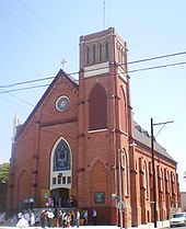 |
2210 Sichel Street34°04′13"N 118°12′45"W | Los Angeles Los Angeles, California Los Angeles , with a population at the 2010 United States Census of 3,792,621, is the most populous city in California, USA and the second most populous in the United States, after New York City. It has an area of , and is located in Southern California... (Lincoln Heights Lincoln Heights, Los Angeles, California -Geography and transportation:Lincoln Heights is bounded by the Los Angeles River on the west, the San Bernardino Freeway on the south, and Indiana Street on the east; the district's Eastern border is unclear due to the area's uneven terrain... ) |
| San Antonio de Padua | 555 North Fairview Avenue34°03′12"N 118°13′15"W | Los Angeles Los Angeles, California Los Angeles , with a population at the 2010 United States Census of 3,792,621, is the most populous city in California, USA and the second most populous in the United States, after New York City. It has an area of , and is located in Southern California... (Boyle Heights) |
|
| San Francisco | 4800 East Olympic Boulevard34°01′03"N 118°09′56"W | East Los Angeles East Los Angeles, California East Los Angeles is an unincorporated area and census-designated place in Los Angeles County, California, United States... |
|
| Santa Isabel | 918 South Soto Street34°02′01"N 118°12′57"W | Los Angeles Los Angeles, California Los Angeles , with a population at the 2010 United States Census of 3,792,621, is the most populous city in California, USA and the second most populous in the United States, after New York City. It has an area of , and is located in Southern California... (Boyle Heights) |
|
| Santa Teresita | 2645 Zonal Avenue34°03′26"N 118°11′51"W | Los Angeles Los Angeles, California Los Angeles , with a population at the 2010 United States Census of 3,792,621, is the most populous city in California, USA and the second most populous in the United States, after New York City. It has an area of , and is located in Southern California... (Lincoln Heights Lincoln Heights, Los Angeles, California -Geography and transportation:Lincoln Heights is bounded by the Los Angeles River on the west, the San Bernardino Freeway on the south, and Indiana Street on the east; the district's Eastern border is unclear due to the area's uneven terrain... ) |
|
| St. Alphonsus | 5223 Hastings Street34°01′33"N 118°09′16"W | East Los Angeles East Los Angeles, California East Los Angeles is an unincorporated area and census-designated place in Los Angeles County, California, United States... |
|
| St. Camillus Catholic Center for Pastoral Care | 1911 Zonal Avenue34°03′40"N 118°12′31"W | Los Angeles Los Angeles, California Los Angeles , with a population at the 2010 United States Census of 3,792,621, is the most populous city in California, USA and the second most populous in the United States, after New York City. It has an area of , and is located in Southern California... (Lincoln Heights Lincoln Heights, Los Angeles, California -Geography and transportation:Lincoln Heights is bounded by the Los Angeles River on the west, the San Bernardino Freeway on the south, and Indiana Street on the east; the district's Eastern border is unclear due to the area's uneven terrain... ) |
|
| St. Lucy | 1419 North Hazard Avenue34°03′21"N 118°10′44"W | City Terrace City Terrace, California City Terrace is an unincorporated community in Los Angeles County, California. It is considered part of the East Los Angeles region. The U.S. census numbers are included with East Los Angeles.-Geography and transportation:... |
|
| St. Marcellinus | 2349 Strong Avenue34°00′15"N 118°09′47"W | City of Commerce | |
| St. Mary | 407 South Chicago Street34°02′29"N 118°12′52"W | Los Angeles Los Angeles, California Los Angeles , with a population at the 2010 United States Census of 3,792,621, is the most populous city in California, USA and the second most populous in the United States, after New York City. It has an area of , and is located in Southern California... (Boyle Heights) |
|
Deanery 10 (Pasadena, Altadena, San Gabriel, Monterey Park, Montebello, Alhambra)
| Church name | Image | Address | Community |
|---|---|---|---|
| All Souls | 17 S. Electric Ave.34°05′27"N 118°08′23"W | Alhambra Alhambra, California Alhambra is a city located in the western San Gabriel Valley region of Los Angeles County, California, United States, which is approximately eight miles from the Downtown Los Angeles civic center. As of the 2010 census, the population was 83,089, down from 85,804 at the 2000 census. The city's... |
|
| St. Thomas More | 2510 S. Fremont Ave.34°03′50"N 118°08′49"W | Alhambra Alhambra, California Alhambra is a city located in the western San Gabriel Valley region of Los Angeles County, California, United States, which is approximately eight miles from the Downtown Los Angeles civic center. As of the 2010 census, the population was 83,089, down from 85,804 at the 2000 census. The city's... |
|
| St. Therese of Lisieux | 510 N. El Molino St.34°06′20"N 118°07′08"W | Alhambra Alhambra, California Alhambra is a city located in the western San Gabriel Valley region of Los Angeles County, California, United States, which is approximately eight miles from the Downtown Los Angeles civic center. As of the 2010 census, the population was 83,089, down from 85,804 at the 2000 census. The city's... |
|
| Sacred Heart | 2889 N. Lincoln Ave.34°11′43"N 118°09′32"W | Altadena Altadena, California Altadena is an unincorporated area and census-designated place in Los Angeles County, California, United States, approximately from the downtown Los Angeles Civic Center, and directly north of the city of Pasadena, California... |
|
| St. Elizabeth | 1879 N. Lake Ave.34°10′40"N 118°07′55"W | Altadena Altadena, California Altadena is an unincorporated area and census-designated place in Los Angeles County, California, United States, approximately from the downtown Los Angeles Civic Center, and directly north of the city of Pasadena, California... |
|
| St. Mary Romanian Greek Catholic Mission | Altadena Altadena, California Altadena is an unincorporated area and census-designated place in Los Angeles County, California, United States, approximately from the downtown Los Angeles Civic Center, and directly north of the city of Pasadena, California... |
||
| Our Lady of the Miraculous Medal | 820 N. Garfield Ave.34°01′49"N 118°07′40"W | Montebello Montebello, California Montebello is a city in Los Angeles County, California, United States, in the southwestern part of the San Gabriel Valley. It is located on of land just east of downtown Los Angeles. It is considered part of the Gateway Cities, and the city is a member of the Gateway Cities Council of... |
|
| St. Benedict | 1022 Cleveland Ave.34°00′46"N 118°06′41"W | Montebello Montebello, California Montebello is a city in Los Angeles County, California, United States, in the southwestern part of the San Gabriel Valley. It is located on of land just east of downtown Los Angeles. It is considered part of the Gateway Cities, and the city is a member of the Gateway Cities Council of... |
|
| St. Stephen | 320 W. Garvey Ave.34°03′43"N 118°07′34"W | Monterey Park Monterey Park, California Monterey Park is a city in Los Angeles County, California, United States, east of downtown Los Angeles. The city's motto is "Pride in the past, Faith in the future"... |
|
| St. Thomas Aquinas | 1501 S. Atlantic Blvd.34°02′43"N 118°08′33"W | Monterey Park Monterey Park, California Monterey Park is a city in Los Angeles County, California, United States, east of downtown Los Angeles. The city's motto is "Pride in the past, Faith in the future"... |
|
| Assumption of the Blessed Virgin Mary | 2640 E. Orange Grove Blvd.34°09′26"N 118°05′45"W | Pasadena Pasadena, California Pasadena is a city in Los Angeles County, California, United States. Although famous for hosting the annual Rose Bowl football game and Tournament of Roses Parade, Pasadena is the home to many scientific and cultural institutions, including the California Institute of Technology , the Jet... |
|
| St. Andrew St. Andrew's Catholic Church, Pasadena St. Andrew's Catholic Church is a Catholic church in Pasadena, California. Founded in the 1880s, it is the oldest Catholic parish in Pasadena and one of the oldest in Los Angeles County. Its Romanesque campanile bell tower is visible for miles and is one of the landmarks of Pasadena. The current... |
.jpg) |
311 N. Raymond Ave.34°09′02"N 118°08′56"W | Pasadena Pasadena, California Pasadena is a city in Los Angeles County, California, United States. Although famous for hosting the annual Rose Bowl football game and Tournament of Roses Parade, Pasadena is the home to many scientific and cultural institutions, including the California Institute of Technology , the Jet... |
| St. Philip the Apostle | 151 South Hill Ave.34°08′37"N 118°07′19"W | Pasadena Pasadena, California Pasadena is a city in Los Angeles County, California, United States. Although famous for hosting the annual Rose Bowl football game and Tournament of Roses Parade, Pasadena is the home to many scientific and cultural institutions, including the California Institute of Technology , the Jet... |
|
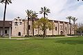
| San Gabriel Mission Mission San Gabriel Arcángel The Mission San Gabriel Arcángel is a fully functioning Roman Catholic mission and a historic landmark in San Gabriel, California. The settlement was founded by Spaniards of the Franciscan order on "The Feast of the Birth of Mary," September 8, 1771, as the fourth of what would become 21 Spanish... |
537 W. Mission Dr.34°05′48"N 118°06′23"W | San Gabriel San Gabriel, California San Gabriel is a city in Los Angeles County, California, United States. It is named after the Mission San Gabriel Arcángel, founded by Junipero Serra. The city grew outward from the mission and in 1852 became the original township of Los Angeles County. San Gabriel was incorporated in 1913... |
|
| St. Anthony | 1901 S. San Gabriel Blvd.34°04′29"N 118°05′28"W | San Gabriel San Gabriel, California San Gabriel is a city in Los Angeles County, California, United States. It is named after the Mission San Gabriel Arcángel, founded by Junipero Serra. The city grew outward from the mission and in 1852 became the original township of Los Angeles County. San Gabriel was incorporated in 1913... |
|
| SS. Felicitas and Perpetua | 1190 Palomar Rd.34°07′37"N 118°05′33"W | San Marino San Marino, California San Marino is a small, affluent city in Los Angeles County, California. Incorporated in 1913, the City founders designed the community to be uniquely residential, with expansive properties surrounded by beautiful gardens, wide streets, and well maintained parkways... |
|
| St. Rita | 50 E. Alegria Ave.34°10′03"N 118°03′04"W | Sierra Madre Sierra Madre, California The city of Sierra Madre is a municipality in Los Angeles County, California whose population was 10,917 at the 2010 census, up from 10,580 at the time of the 2000 census. The city is located in the Foothills of the San Gabriel Mountains below the southern edge of the Angeles National Forest. ... |
|
| Holy Family | 1527 Fremont Ave.34°06′28"N 118°09′12"W | South Pasadena South Pasadena, California South Pasadena is a city in Los Angeles County, California, United States. As of the 2010 census, it had a population of 25,619, up from 24,292 at the 2000 census. It is located in in the West San Gabriel Valley... |
|
| St. Luke the Evangelist | 5605 Cloverly Ave.34°06′04"N 118°03′46"W | Temple City Temple City, California Temple City is a city in Los Angeles County, California. Temple City is part of a cluster of cities, along with Arcadia, Rosemead, Monterey Park, San Marino, and San Gabriel, in the west San Gabriel Valley with a rapidly growing Asian population. Temple City also has a Cuban and Puerto Rican... |
|
Deanery 11 (Arcadia, Covina, Glendora, Monrovia, La Puente)
| Church name | Image | Address | Community |
|---|---|---|---|
| Annunciation | 1307 E. Longden Ave.34°06′52"N 118°00′18"W | Mayflower Village Mayflower Village, California Mayflower Village is a census-designated place in the San Gabriel Valley, in Los Angeles County, California, United States. The population was 5,515 at the 2010 census, up from 5,081 at the 2000 census... |
|
| Holy Angels | 370 Campus Dr.34°07′51"N 118°02′44"W | Arcadia Arcadia, California Arcadia is an affluent city in Los Angeles County, California, United States, and located approximately northeast of downtown Los Angeles in the San Gabriel Valley and at the base of the San Gabriel Mountains.... |
|
| St. Frances of Rome | 501 East Foothill Boulevard34°08′00"N 117°54′08"W | Azusa Azusa, California Azusa is a city in Los Angeles County, California, United States. The population was 46,361 at the 2010 census, up from 44,712 at the 2000 census. Though sometimes assumed to be a compaction of the phrase "everything from A to Z in the USA" from an old Jack Benny joke, the place name "Azusa"... |
|
| St. John the Baptist | 3848 Stewart Avenue34°04′55"N 117°58′02"W | Baldwin Park Baldwin Park, California Baldwin Park is a city located in the central San Gabriel Valley region of Los Angeles County, California, United States. As of the 2010 census, the population was 75,390, down from 75,837 at the 2000 census.- History :... |
|
| Sacred Heart | 314 West Workman Street34°04′31"N 117°53′39"W | Covina Covina, California Covina is a small city in Los Angeles County, California about east of downtown Los Angeles, in the San Gabriel Valley region. The population was 47,796 at the 2010 census, up from 46,837 at the 2000 census... |
|
| St. Louise de Marillac | 1720 East Covina Boulevard34°05′57"N 117°52′46"W | Covina Covina, California Covina is a small city in Los Angeles County, California about east of downtown Los Angeles, in the San Gabriel Valley region. The population was 47,796 at the 2010 census, up from 46,837 at the 2000 census... |
|
| Nativity | 3743 North Tyler Avenue34°04′41"N 118°02′01"W | El Monte El Monte, California El Monte is a residential, industrial, and commercial city in Los Angeles County, California, United States. The city's slogan is "Welcome to Friendly El Monte," and historically is known as "The End of the Santa Fe Trail." As of the 2010 census, the city had a total population of 113,475,... |
|
| Our Lady of Guadalupe | 11359 Coffield Avenue34°04′28"N 118°01′32"W | El Monte El Monte, California El Monte is a residential, industrial, and commercial city in Los Angeles County, California, United States. The city's slogan is "Welcome to Friendly El Monte," and historically is known as "The End of the Santa Fe Trail." As of the 2010 census, the city had a total population of 113,475,... |
|
| Epiphany | 10911 Michael Hunt Drive34°02′43"N 118°02′30"W | South El Monte South El Monte, California South El Monte is a city in the San Gabriel Valley, in Los Angeles County, California, United States. As of the 2010 census, the city had a population of 20,116, down from 21,144 at the 2000 census.-Geography:... |
|
| St. Dorothy | 241 South Valley Center Avenue34°06′24"N 117°50′15"W | Glendora Glendora, California Glendora is a municipality in Los Angeles County, California, United States, east of downtown Los Angeles. As of the 2010 census, the population of Glendora was 50,073.... |
|
| Our Lady of Guadalupe | 16025 East Cypress Street34°05′46"N 117°55′59"W | Irwindale Irwindale, California Irwindale is a city in the San Gabriel Valley, in Los Angeles County, California, United States. The population was 1,422 at the 2010 census, down from 1,446 at the 2000 census.... |
|
| St. Louis of France | 13935 East Temple Avenue34°02′53"N 117°58′41"W | La Puente La Puente, California La Puente is a city in Los Angeles County, California, United States. The population was 39,816 at the 2010 census.* City flower: The Golden Hibiscus* City colors: Green and White.-History:... (Bassett Bassett, California Bassett is an unincorporated community in the San Gabriel Valley, in Los Angeles County, California, United States, located within the Census boundaries of Avocado Heights... ) |
|
| Immaculate Conception | 740 South Shamrock Avenue34°08′36"N 117°59′26"W | Monrovia Monrovia, California Monrovia is a city located in the foothills of the San Gabriel Mountains in the San Gabriel Valley of Los Angeles County, California, United States. The population was 36,590 at the 2010 census, down from 36,929 at the 2000 census... |
|
| St. Christopher | 629 South Glendora Avenue34°03′53"N 117°55′43"W | West Covina West Covina, California West Covina is a city located in Los Angeles County, California. Located some east of Downtown Los Angeles in the eastern San Gabriel Valley, it is a mostly middle class suburb of Los Angeles... |
|
Deanery 12 (San Dimas, Claremont, Pomona, Diamond Bar, La Puente, Valinda, Walnut)
| Church name | Image | Address | Community |
|---|---|---|---|
| Our Lady of the Assumption | 435 Berkeley Ave.34°05′51"N 117°43′23"W | Claremont Claremont, California Claremont is a small affluent college town in eastern Los Angeles County, California, United States, about east of downtown Los Angeles at the base of the San Gabriel Mountains. The population as of the 2010 census is 34,926. Claremont is known for its seven higher-education institutions, its... |
|
| St. Denis | 2151 Diamond Bar Blvd.33°59′09"N 117°43′23"W | Diamond Bar Diamond Bar, California Diamond Bar is a city in eastern Los Angeles County, California, United States. The population was 55,544 at the 2010 census, down from 56,287 at the 2000 census. It is named after the "diamond over a bar" branding iron registered in 1918 by ranch owner Frederick E... |
|
| St. John Vianney | 1345 Turnbull Canyon Rd.34°00′37"N 117°58′44"W | Hacienda Heights Hacienda Heights, California Hacienda Heights is an unincorporated census-designated place in and below the Puente Hills of the San Gabriel Valley, in Los Angeles County, California, United States... |
|
| St. Joseph | 550 N. Glendora Ave. | La Puente La Puente, California La Puente is a city in Los Angeles County, California, United States. The population was 39,816 at the 2010 census.* City flower: The Golden Hibiscus* City colors: Green and White.-History:... |
|
| Sacred Heart | 1215 S. Hamilton Blvd.34°02′54"N 117°45′48"W | Pomona Pomona, California -2010:The 2010 United States Census reported that Pomona had a population of 149,058, a slight decline from the 2000 census population. The population density was 6,491.2 people per square mile... |
|
| St. Joseph | 1150 W. Holt Ave.34°03′39"N 117°46′07"W | Pomona Pomona, California -2010:The 2010 United States Census reported that Pomona had a population of 149,058, a slight decline from the 2000 census population. The population density was 6,491.2 people per square mile... |
|
| St. Madeleine | 931 E. Kingsley Ave.34°04′00"N 117°43′57"W | Pomona Pomona, California -2010:The 2010 United States Census reported that Pomona had a population of 149,058, a slight decline from the 2000 census population. The population density was 6,491.2 people per square mile... |
|
| St. Elizabeth Ann Seton | 1835 Larkvane Rd.33°59′11"N 117°54′33"W | Rowland Heights Rowland Heights, California Rowland Heights is an unincorporated community of , located in and below the Puente Hills in the San Gabriel Valley, in Los Angeles County, California. The population of the census-designated place was 48,993 at the 2010 census, up from 48,553 at the 2000 census... |
|
| Holy Name of Mary | 724 E. Bonita Ave.34°06′22"N 117°49′36"W | San Dimas San Dimas, California San Dimas is a city located in the San Gabriel Valley, in Los Angeles County, California. As of the 2010 census, the city had a total population of 33,371. The city historically took its name from San Dismas Canyon in the San Gabriel Mountains above the northern section of present day San Dimas... |
|
| St. Martha | 444 N. Azusa Ave. | Valinda Valinda, California Valinda is a census-designated place in the San Gabriel Valley, in Los Angeles County, California, in the United States. As of the 2010 census, the population was 22,822, up from 21,776 at the 2000 census.-Geography:... |
|
| St. Lorenzo Ruiz | 747 Meadow Pass Rd.34°01′38"N 117°51′58"W | Walnut Walnut, California Walnut is a city in Los Angeles County, California, United States. The population was 29,172 at the 2010 census and its current mayor is Tom King, a former Detective from the Los Angeles Police Department.... |
|
Spanish Missions
| Mission name | Image | Address | Community |
|---|---|---|---|
| Mission San Gabriel Arcángel Mission San Gabriel Arcángel The Mission San Gabriel Arcángel is a fully functioning Roman Catholic mission and a historic landmark in San Gabriel, California. The settlement was founded by Spaniards of the Franciscan order on "The Feast of the Birth of Mary," September 8, 1771, as the fourth of what would become 21 Spanish... |
 |
537 W. Mission Dr.34°05′48"N 118°06′23"W | San Gabriel San Gabriel, California San Gabriel is a city in Los Angeles County, California, United States. It is named after the Mission San Gabriel Arcángel, founded by Junipero Serra. The city grew outward from the mission and in 1852 became the original township of Los Angeles County. San Gabriel was incorporated in 1913... |
High schools
| School name | Image | Address | Community |
|---|---|---|---|
| Ramona Convent Secondary School Ramona Convent Secondary School Ramona Convent Secondary School is a private, Catholic, college preparatory school for girls grades 7-12. Established in 1889 by the Sisters of the Holy Names, Ramona is one of the oldest continually operating schools in the same location in California and has graduated over 8,300 students... |
1701 W. Ramona Rd.34°04′24"N 118°08′23"W | Alhambra Alhambra, California Alhambra is a city located in the western San Gabriel Valley region of Los Angeles County, California, United States, which is approximately eight miles from the Downtown Los Angeles civic center. As of the 2010 census, the population was 83,089, down from 85,804 at the 2000 census. The city's... |
|
| St. Lucy's Priory High School St. Lucy's Priory High School St. Lucy's Priory High School is a private, Roman Catholic, all-girls high school in Glendora, California built in 1963. It is located in the Roman Catholic Archdiocese of Los Angeles.-History and Traditions:St... |
655 W. Sierra Madre Ave.34°08′53"N 117°52′37"W | Glendora Glendora, California Glendora is a municipality in Los Angeles County, California, United States, east of downtown Los Angeles. As of the 2010 census, the population of Glendora was 50,073.... |
|
| Bishop Amat High School | 14301 Fairgrove Ave.34°03′15"N 117°57′54"W | La Puente La Puente, California La Puente is a city in Los Angeles County, California, United States. The population was 39,816 at the 2010 census.* City flower: The Golden Hibiscus* City colors: Green and White.-History:... |
|
| Damien High School Damien High School Damien High School is a private, all-male Roman Catholic high school in La Verne, California named for Saint Damien of Molokai. The school had its first graduating class in 1963. Each of Damien's freshmen classes draws from an average of over 75 different elementary and junior high schools for... |
2280 Damien Ave.34°06′15"N 117°47′14"W | La Verne La Verne, California La Verne is a city in Los Angeles County, California, United States. The population was 31,063 at the 2010 census, down from 31,638 at the 2000 census.-History:... |
|
| Bishop Mora Salesian High School | 960 S. Soto St.34°01′58"N 118°12′58"W | Los Angeles Los Angeles, California Los Angeles , with a population at the 2010 United States Census of 3,792,621, is the most populous city in California, USA and the second most populous in the United States, after New York City. It has an area of , and is located in Southern California... |
|
| Sacred Heart High School | 2111 N. Griffin Ave.34°04′11"N 118°12′43"W | Los Angeles Los Angeles, California Los Angeles , with a population at the 2010 United States Census of 3,792,621, is the most populous city in California, USA and the second most populous in the United States, after New York City. It has an area of , and is located in Southern California... |
|
| Cantwell Sacred Heart of Mary School Cantwell Sacred Heart of Mary School Cantwell-Sacred Heart of Mary High School , is a Roman Catholic high school located in Montebello, California, precisely on the border of East Los Angeles and Montebello. It is now owned and operated by the Archdiocese of Los Angeles... |
329 N. Garfield Ave.34°01′02"N 118°07′48"W | Montebello Montebello, California Montebello is a city in Los Angeles County, California, United States, in the southwestern part of the San Gabriel Valley. It is located on of land just east of downtown Los Angeles. It is considered part of the Gateway Cities, and the city is a member of the Gateway Cities Council of... |
|
| La Salle High School La Salle High School (Pasadena, California) La Salle High School is a private, Roman Catholic college preparatory high school in Pasadena, California. It is located in the Roman Catholic Archdiocese of Los Angeles.La Salle High School, founded in 1956, is a Lasallian school... |
3880 E. Sierra Madre Blvd.34°09′40"N 118°04′05"W | Pasadena Pasadena, California Pasadena is a city in Los Angeles County, California, United States. Although famous for hosting the annual Rose Bowl football game and Tournament of Roses Parade, Pasadena is the home to many scientific and cultural institutions, including the California Institute of Technology , the Jet... |
|
| Mayfield Senior School Mayfield Senior School Mayfield Senior School is a Catholic, independent, college preparatory school founded in 1931 for young women grades 9-12, sponsored by the Society of the Holy Child Jesus and a member of the Holy Child Network of Schools and guided by the educational philosophy of the Society's foundress, Cornelia... |
500 Bellefontaine St.34°07′49"N 118°09′41"W | Pasadena Pasadena, California Pasadena is a city in Los Angeles County, California, United States. Although famous for hosting the annual Rose Bowl football game and Tournament of Roses Parade, Pasadena is the home to many scientific and cultural institutions, including the California Institute of Technology , the Jet... |
|
| St. Monica Academy St. Monica Academy (Pasadena, California) St. Monica Academy is a private, independent Roman Catholic high school in Pasadena, California. It is operated independently of the Roman Catholic Archdiocese of Los Angeles.-Background:St. Monica Academy was established in 2001 by lay parents... |
301 N. Orange Grove Blvd.34°08′59"N 118°09′36"W | Pasadena Pasadena, California Pasadena is a city in Los Angeles County, California, United States. Although famous for hosting the annual Rose Bowl football game and Tournament of Roses Parade, Pasadena is the home to many scientific and cultural institutions, including the California Institute of Technology , the Jet... |
|
| Pomona Catholic High School Pomona Catholic High School Pomona Catholic High School is a four-year Archdiocesan high school for girls in Pomona on Holt and White. It is located in the Roman Catholic Archdiocese of Los Angeles.-History:... |
533 W. Holt Ave.34°03′45"N 117°45′29"W | Pomona Pomona, California -2010:The 2010 United States Census reported that Pomona had a population of 149,058, a slight decline from the 2000 census population. The population density was 6,491.2 people per square mile... |
|
| San Gabriel Mission High School San Gabriel Mission High School San Gabriel Mission High School, the "school with a mission," is an all-girl's Catholic College Preparatory high school located on the grounds of the fourth mission of California, which was founded in 1771 by the Franciscan Padres and often used by Father Junipero Serra as his headquarters. It is... |
254 S. Santa Anita St.34°05′56"N 118°06′25"W | San Gabriel San Gabriel, California San Gabriel is a city in Los Angeles County, California, United States. It is named after the Mission San Gabriel Arcángel, founded by Junipero Serra. The city grew outward from the mission and in 1852 became the original township of Los Angeles County. San Gabriel was incorporated in 1913... |
|
| Alverno High School Alverno High School Alverno High School is an independent, Catholic, college-prep high school for girls located in the Sierra Madre/Pasadena area of Southern California.-History:Alverno High School was originally the home of prominent Los Angeles physician Walter Jarvis Barlow... |
200 N. Michillinda Ave.34°09′56"N 118°03′59"W | Sierra Madre Sierra Madre, California The city of Sierra Madre is a municipality in Los Angeles County, California whose population was 10,917 at the 2010 census, up from 10,580 at the time of the 2000 census. The city is located in the Foothills of the San Gabriel Mountains below the southern edge of the Angeles National Forest. ... |
|
Elementary schools
- All Souls, Alhambra
- Ramona Convent, Alhambra
- St. Therese, Alhambra
- St. Thomas More, Alhambra
- St. Elizabeth, Altadena
- Annunciation, Arcadia
- Holy Angels, Arcadia
- St. Frances of Rome, Azusa
- St. John the Baptist, Baldwin Park
- Our Lady of the Assumption, Claremont
- Sacred Heart, Covina
- St. Louise de Marillac, Covina
- Nativity, El Monte
- St. Dorothy, Glendora
- St. Joseph, La Puente
- St. Louis of France, La Puente
- St. Martha, La Puente
- All Saints, Los Angeles
- Assumption, Los Angeles
- Dolores Mission, Los Angeles
- Our Lady Help of Christians, Los Angeles
- Our Lady of Guadalupe, 436 N. Hazard Ave., Los Angeles
- Our Lady of Guadalupe, 4522 Browne Ave., Los Angeles
- Our Lady of Lourdes, Los Angeles
- Our Lady of Soledad, Los Angeles
- Our Lady of Talpa, Los Angeles
- Resurrection, Los Angeles
- Sacred Heart, Los Angeles
- San Antonio de Padua, Los Angeles
- Santa Isabel, Los Angeles
- Santa Teresita, Los Angeles
- St. Alphonsus, Los Angeles
- St. Mary, Los Angeles
- Immaculate Conception, Monrovia
- Our Lady of the Miraculous Medal, Montebello
- St. Benedict, Montebello
- St. Stephen, Monterey Park
- St. Thomas Aquinas, Monterey Park
- Armenian Sisters Academy, Montrose
- Assumption of the BVM, Pasadena
- Mayfield Junior School, Pasadena
- St. Andrew, Pasadena
- St. Philip the Apostle, Pasadena
- St. Joseph, Pomona
- St. Madeleine, Pomona
- Holy Name of Mary, San Dimas
- San Gabriel Mission, San Gabriel
- St. Anthony, San Gabriel
- SS. Felicitas & Perpetua, San Marino
- St. Rita, Sierra Madre
- Epiphany, So. El Monte
- Holy Family, So. Pasadena
- St. Luke, Temple City
- St. Christopher, West Covina
Cemeteries
- Calvary CemeteryCalvary Cemetery, East Los AngelesThe Calvary Cemetery is a Roman Catholic cemetery operated by the Los Angeles Archdiocese, located at 4201 Whittier Boulevard in Los Angeles, California...
, East Los AngelesEast Los Angeles, CaliforniaEast Los Angeles is an unincorporated area and census-designated place in Los Angeles County, California, United States... - Holy Cross Cemetery, PomonaPomona, California-2010:The 2010 United States Census reported that Pomona had a population of 149,058, a slight decline from the 2000 census population. The population density was 6,491.2 people per square mile...
See also
Roman Catholic Archdiocese of Los AngelesRoman Catholic Archdiocese of Los Angeles
The Archdiocese of Los Angeles is an archdiocese of the Roman Catholic Church in the U.S. state of California. Headquartered in Los Angeles, the archdiocese comprises the California counties of Los Angeles, Santa Barbara and Ventura. The diocesan cathedral is the Cathedral of Our Lady of the...
- Our Lady of the Angels Pastoral RegionOur Lady of the Angels Pastoral RegionThe Our Lady of the Angels Pastoral Region is a pastoral region of the Archdiocese of Los Angeles in the Roman Catholic Church. It covers Downtown and central Los Angeles west to Malibu, south to LAX. The current regional auxiliary bishop is Bishop Edward W. Clark...
- San Fernando Pastoral RegionSan Fernando Pastoral RegionThe San Fernando Pastoral Region is a pastoral region of the Archdiocese of Los Angeles in the Roman Catholic Church. It covers the San Fernando, Santa Clarita, and Antelope Valleys. The current regional auxiliary bishop is Bishop Gerald E. Wilkerson...
- San Pedro Pastoral RegionSan Pedro Pastoral RegionThe San Pedro Pastoral Region is a pastoral region of the Archdiocese of Los Angeles in the Roman Catholic Church. It covers Long Beach and southern Los Angeles County. The current regional auxiliary bishop is Bishop Oscar A. Solis...
- Santa Barbara Pastoral RegionSanta Barbara Pastoral RegionThe Santa Barbara Pastoral Region is a pastoral region of the Archdiocese of Los Angeles in the Roman Catholic Church. It covers Santa Barbara and Ventura counties in the state of California, USA. The current regional auxiliary bishop is Bishop Thomas J. Curry...
List of schools in the Roman Catholic Archdiocese of Los Angeles