

Our Lady of the Angels Pastoral Region
Encyclopedia
The Our Lady of the Angels Pastoral Region is a pastoral region of the Archdiocese of Los Angeles
in the Roman Catholic Church
. It covers Downtown and central Los Angeles
west to Malibu, south to LAX. The current regional auxiliary bishop
is Bishop Edward W. Clark
. The Region has 76 parish
es, 10 high schools, many elementary schools, 5 hospitals, and 0 Spanish Missions
.
, but rather, a parish church.
Daniel Murphy High School
, located at 241 S. Detroit St., Los Angeles, closed in 2008.
List of schools in the Roman Catholic Archdiocese of Los Angeles
Roman Catholic Archdiocese of Los Angeles
The Archdiocese of Los Angeles is an archdiocese of the Roman Catholic Church in the U.S. state of California. Headquartered in Los Angeles, the archdiocese comprises the California counties of Los Angeles, Santa Barbara and Ventura. The diocesan cathedral is the Cathedral of Our Lady of the...
in the Roman Catholic Church
Roman Catholic Church
The Catholic Church, also known as the Roman Catholic Church, is the world's largest Christian church, with over a billion members. Led by the Pope, it defines its mission as spreading the gospel of Jesus Christ, administering the sacraments and exercising charity...
. It covers Downtown and central Los Angeles
Los Ángeles
Los Ángeles is the capital of the province of Biobío, in the commune of the same name, in Region VIII , in the center-south of Chile. It is located between the Laja and Biobío rivers. The population is 123,445 inhabitants...
west to Malibu, south to LAX. The current regional auxiliary bishop
Auxiliary bishop
An auxiliary bishop, in the Roman Catholic Church, is an additional bishop assigned to a diocese because the diocesan bishop is unable to perform his functions, the diocese is so extensive that it requires more than one bishop to administer, or the diocese is attached to a royal or imperial office...
is Bishop Edward W. Clark
Edward W. Clark
Edward William Clark is an American prelate of the Roman Catholic Church. He currently serves as an auxiliary bishop of the Archdiocese of Los Angeles.-Biography:...
. The Region has 76 parish
Parish
A parish is a territorial unit historically under the pastoral care and clerical jurisdiction of one parish priest, who might be assisted in his pastoral duties by a curate or curates - also priests but not the parish priest - from a more or less central parish church with its associated organization...
es, 10 high schools, many elementary schools, 5 hospitals, and 0 Spanish Missions
Spanish missions in California
The Spanish missions in California comprise a series of religious and military outposts established by Spanish Catholics of the Franciscan Order between 1769 and 1823 to spread the Christian faith among the local Native Americans. The missions represented the first major effort by Europeans to...
.
Deanery 13 (Westside)
| Church name | Image | Address | Community | School |
|---|---|---|---|---|
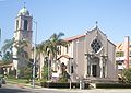
| Corpus Christihttp://www.corpuschristichurch.com/ | 887 Toyopa Dr.34°02′39"N 118°31′27"W | Los Angeles Los Ángeles Los Ángeles is the capital of the province of Biobío, in the commune of the same name, in Region VIII , in the center-south of Chile. It is located between the Laja and Biobío rivers. The population is 123,445 inhabitants... (Pacific Palisades Pacific Palisades, Los Angeles, California Pacific Palisades is an affluent neighborhood and district within the U.S. city of Los Angeles, California, located among Brentwood to the east, Malibu and Topanga to the west, Santa Monica to the southeast, the Santa Monica Bay to the southwest, and the Santa Monica Mountains to the north. The... ) |
K-8http://www.archdiocese.la/directories/schools/info.php?school_id=25 | |
| Our Lady of Malibuhttp://www.olmalibu.org/ | 3625 Winter Canyon Rd.34°02′20"N 118°41′57"W | Malibu | K-8http://www.archdiocese.la/directories/schools/info.php?school_id=92 | |
| St. Annehttp://www.stanneshrine.org/aboutus.html | 2011 Colorado Ave.34°01′35"N 118°28′35"W | Santa Monica Santa Monica, California Santa Monica is a beachfront city in western Los Angeles County, California, US. Situated on Santa Monica Bay, it is surrounded on three sides by the city of Los Angeles — Pacific Palisades on the northwest, Brentwood on the north, West Los Angeles on the northeast, Mar Vista on the east, and... |
K-8http://www.archdiocese.la/directories/schools/info.php?school_id=140 | |
| St. Clementhttp://www.stclementscc.org/ | 3102 3rd St.33°59′54"N 118°28′40"W | Santa Monica Santa Monica, California Santa Monica is a beachfront city in western Los Angeles County, California, US. Situated on Santa Monica Bay, it is surrounded on three sides by the city of Los Angeles — Pacific Palisades on the northwest, Brentwood on the north, West Los Angeles on the northeast, Mar Vista on the east, and... |
No | |
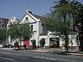
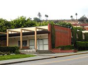
| St. Monica St. Monica Catholic Church, Santa Monica St. Monica Catholic Church is a Catholic church in Santa Monica, California. The church, located at 7th and California Streets, was erected in 1926 and was featured in the 1944 film classic Going My Way with Bing Crosby. It is also the home parish of former California Governor Arnold Schwarzenegger... |
.jpg) |
725 California Ave.34°01′23"N 118°29′49"W | Santa Monica Santa Monica, California Santa Monica is a beachfront city in western Los Angeles County, California, US. Situated on Santa Monica Bay, it is surrounded on three sides by the city of Los Angeles — Pacific Palisades on the northwest, Brentwood on the north, West Los Angeles on the northeast, Mar Vista on the east, and... |
K-8http://www.archdiocese.la/directories/schools/info.php?school_id=245 9-12http://www.archdiocese.la/directories/schools/info.php?school_id=246 |
| St. Markhttp://www.st-mark.net/ | 940 Coeur D' Alene Ave.33°59′32"N 118°27′05"W | Los Angeles Los Ángeles Los Ángeles is the capital of the province of Biobío, in the commune of the same name, in Region VIII , in the center-south of Chile. It is located between the Laja and Biobío rivers. The population is 123,445 inhabitants... (Venice Venice, Los Angeles, California Venice is a beachfront district on the Westside of Los Angeles, California, United States. It is known for its canals, beaches and circus-like Ocean Front Walk, a two-and-a-half mile pedestrian-only promenade that features performers, fortune-tellers, artists, and vendors... ) |
K-8http://www.archdiocese.la/directories/schools/info.php?school_id=231 | |
| St. Augustine St. Augustine Catholic Church, Culver City St. Augustine Catholic Church is a Catholic church located in Culver City, California, part of the Roman Catholic Archdiocese of Los Angeles. The church is located across the street from the Sony Studios, previously the MGM Studios.-The mission church:... |
10195 Washington Blvd.34°01′12"N 118°24′01"W | Culver City Culver City, California Culver City is a city in western Los Angeles County, California. As of the 2010 census, the city had a population of 38,883, up from 38,816 at the 2000 census. It is mostly surrounded by the city of Los Angeles, but also shares a border with unincorporated areas of Los Angeles County. Culver... |
K-8http://www.archdiocese.la/directories/schools/info.php?school_id=149 | |
| St. Jeromehttp://www.stjeromewestchester.org/ | 5550 Thornburn St.33°58′24"N 118°22′38"W | Los Angeles Los Ángeles Los Ángeles is the capital of the province of Biobío, in the commune of the same name, in Region VIII , in the center-south of Chile. It is located between the Laja and Biobío rivers. The population is 123,445 inhabitants... (Westchester Westchester, Los Angeles, California Westchester is a suburban neighborhood in western Los Angeles, California, United States. It is home to Los Angeles International Airport , Loyola Marymount University , and Otis College of Art and Design.-Geography:... ) |
K-8http://www.archdiocese.la/directories/schools/info.php?school_id=201 | |
| Visitationhttp://www.visitationschool.org/ | 8740 S. Emerson Ave.33°57′29"N 118°24′13"W | Los Angeles Los Ángeles Los Ángeles is the capital of the province of Biobío, in the commune of the same name, in Region VIII , in the center-south of Chile. It is located between the Laja and Biobío rivers. The population is 123,445 inhabitants... (Westchester Westchester, Los Angeles, California Westchester is a suburban neighborhood in western Los Angeles, California, United States. It is home to Los Angeles International Airport , Loyola Marymount University , and Otis College of Art and Design.-Geography:... ) |
K-8http://www.archdiocese.la/directories/schools/info.php?school_id=280 | |
| St. Anastasiahttp://www.st-anastasia.org/ | 7390 West Manchester Ave.33°57′34"N 118°25′32"W | Los Angeles Los Ángeles Los Ángeles is the capital of the province of Biobío, in the commune of the same name, in Region VIII , in the center-south of Chile. It is located between the Laja and Biobío rivers. The population is 123,445 inhabitants... (Westchester Westchester, Los Angeles, California Westchester is a suburban neighborhood in western Los Angeles, California, United States. It is home to Los Angeles International Airport , Loyola Marymount University , and Otis College of Art and Design.-Geography:... ) |
K-8http://www.archdiocese.la/directories/schools/info.php?school_id=138 | |
| St. Martin of Tours St. Martin of Tours Catholic Church St. Martin of Tours Catholic Church is a Roman Catholic church and parish in the Los Angeles Archdiocese, Our Lady of the Angels Pastoral Region. The church is located on Sunset Boulevard in the affluent Brentwood section of Los Angeles, California.... |
11967 Sunset Blvd.34°03′32"N 118°28′28"W | Los Angeles Los Ángeles Los Ángeles is the capital of the province of Biobío, in the commune of the same name, in Region VIII , in the center-south of Chile. It is located between the Laja and Biobío rivers. The population is 123,445 inhabitants... (Brentwood Brentwood, Los Angeles, California Brentwood is a district in western Los Angeles, California, United States. The district is located at the base of the Santa Monica Mountains, bounded by the San Diego Freeway on the east, Wilshire Boulevard on the south, the Santa Monica city limits on the southwest, the border of Topanga State... ) |
K-8http://www.archdiocese.la/directories/schools/info.php?school_id=233 | |
| St. Sebastianhttp://saintsebastianschool.com/about.html | 11607 Ohio Ave.34°02′44"N 118°27′18"W | Los Angeles Los Ángeles Los Ángeles is the capital of the province of Biobío, in the commune of the same name, in Region VIII , in the center-south of Chile. It is located between the Laja and Biobío rivers. The population is 123,445 inhabitants... (West Los Angeles West Los Angeles, Los Angeles, California West Los Angeles is a district in Los Angeles, California, within a larger region known as the "Westside."-Geography and transportation:... ) |
K-8http://www.archdiocese.la/directories/schools/info.php?school_id=267 | |
| St. Paul the Apostlehttp://www.sp-apostle.org/ | 10750 Ohio Ave.34°03′21"N 118°26′14"W | Los Angeles Los Ángeles Los Ángeles is the capital of the province of Biobío, in the commune of the same name, in Region VIII , in the center-south of Chile. It is located between the Laja and Biobío rivers. The population is 123,445 inhabitants... (Westwood Westwood, Los Angeles, California Westwood is a neighborhood on the Westside of Los Angeles, California, United States. It is the home of the University of California, Los Angeles .-History:... ) |
K-8http://www.archdiocese.la/directories/schools/info.php?school_id=254 | |
| St. Joan of Archttp://www.stjoanofarcla.com/ | 11534 Gateway Blvd.34°01′54"N 118°26′30"W | Los Angeles Los Ángeles Los Ángeles is the capital of the province of Biobío, in the commune of the same name, in Region VIII , in the center-south of Chile. It is located between the Laja and Biobío rivers. The population is 123,445 inhabitants... (West Los Angeles West Los Angeles, Los Angeles, California West Los Angeles is a district in Los Angeles, California, within a larger region known as the "Westside."-Geography and transportation:... ) |
K-8http://www.archdiocese.la/directories/schools/info.php?school_id=202 | |
| St. Timothy St. Timothy Catholic Church St. Timothy Catholic Church is a Roman Catholic parish in the Los Angeles Archdiocese, Our Lady of the Angels Pastoral Region. The church is located at 10425 West Pico Boulevard in the Rancho Park neighborhood on the westside of Los Angeles, California, USA. Its Spanish Renaissance style church was... |
 |
10425 W Pico Blvd.34°03′46"N 118°25′04"W | Los Angeles Los Ángeles Los Ángeles is the capital of the province of Biobío, in the commune of the same name, in Region VIII , in the center-south of Chile. It is located between the Laja and Biobío rivers. The population is 123,445 inhabitants... (Rancho Park Rancho Park, Los Angeles, California Rancho Park is a small residential neighborhood in West Los Angeles, California with mostly single family homes and tree lined streets. The community is nestled between Westwood and Cheviot Hills. This enclave draws young professionals and families and is home to residents working in a variety of... ) |
K-8http://www.archdiocese.la/directories/schools/info.php?school_id=274 |
| Good Shepherd Roman Catholic Church of the Good Shepherd (Beverly Hills) The Church of the Good Shepherd, located at 505 North Bedford Drive is now the oldest church in Beverly Hills. It has only 600 seats.Over the years, this small house of worship has been the local parish church for most of the Catholic movie stars who live in Beverly Hills, from Rudolph Valentino to... |
505 N. Bedford Dr.34°04′10"N 118°24′25"W | Beverly Hills Beverly Hills, California Beverly Hills is an affluent city located in Los Angeles County, California, United States. With a population of 34,109 at the 2010 census, up from 33,784 as of the 2000 census, it is home to numerous Hollywood celebrities. Beverly Hills and the neighboring city of West Hollywood are together... |
K-8http://www.archdiocese.la/directories/schools/info.php?school_id=35 | |
| Our Lady of Mount Lebanon - St. Peter Cathedralhttp://www.ourladyofmountlebanon.com/root/oloml/sf_home.asp | 333 S. San Vicente Blvd.34°04′21"N 118°22′38"W | Los Angeles Los Angeles, California Los Angeles , with a population at the 2010 United States Census of 3,792,621, is the most populous city in California, USA and the second most populous in the United States, after New York City. It has an area of , and is located in Southern California... (Beverly Center) |
No | |
| St. Gerard Majellahttp://www.stgerardla.com/ | 4439 Inglewood Blvd.33°59′43"N 118°25′08"W | Los Angeles Los Angeles, California Los Angeles , with a population at the 2010 United States Census of 3,792,621, is the most populous city in California, USA and the second most populous in the United States, after New York City. It has an area of , and is located in Southern California... (Mar Vista Mar Vista, Los Angeles, California Mar Vista is a district on the West Side of Los Angeles, California.-Geography and transportation:Mar Vista is near the center of LA's West Side. The city of Santa Monica lies to the northwest, West Los Angeles to the north, Palms to the northeast, Culver City to the east, Del Rey to the southwest,... ) |
K-8http://www.archdiocese.la/directories/schools/info.php?school_id=191 | |
| St. Ambrosehttp://www.st-ambrose.com/ | 1281 N. Fairfax Ave.34°05′39"N 118°21′42"W | West Hollywood West Hollywood, California West Hollywood, a city of Los Angeles County, California, was incorporated on November 29, 1984, with a population of 34,399 at the 2010 census. 41% of the city's population is made up of gay men according to a 2002 demographic analysis by Sara Kocher Consulting for the City of West Hollywood... |
No | |
| St. Victorhttp://www.saintvictor.org/home.html | 8634 Holloway Dr.34°05′25"N 118°22′49"W | West Hollywood West Hollywood, California West Hollywood, a city of Los Angeles County, California, was incorporated on November 29, 1984, with a population of 34,399 at the 2010 census. 41% of the city's population is made up of gay men according to a 2002 demographic analysis by Sara Kocher Consulting for the City of West Hollywood... |
No | |
Deanery 14 (Central LA/Hollywood)
| Church name | Image | Address | Community | School |
|---|---|---|---|---|
| Blessed Sacrament Blessed Sacrament Catholic Church, Hollywood Blessed Sacrament Catholic Church is a parish in the Roman Catholic Archdiocese of Los Angeles located on Sunset Boulevard in the heart of Hollywood, California. The church today serves an urban, multiethnic community and is known for, among other things, its gay and lesbian ministry and its many... |
6657 W. Sunset Blvd.34°05′53"N 118°20′06"W | Los Angeles Los Ángeles Los Ángeles is the capital of the province of Biobío, in the commune of the same name, in Region VIII , in the center-south of Chile. It is located between the Laja and Biobío rivers. The population is 123,445 inhabitants... (Hollywood Hollywood, Los Angeles, California Hollywood is a famous district in Los Angeles, California, United States situated west-northwest of downtown Los Angeles. Due to its fame and cultural identity as the historical center of movie studios and movie stars, the word Hollywood is often used as a metonym of American cinema... ) |
K-8http://www.archdiocese.la/directories/schools/info.php?school_id=18 | |
| St. Vibianahttp://www.cathedralchapel.org/ | 923 South La Brea Ave.34°03′28"N 118°20′45"W | Los Angeles Los Angeles, California Los Angeles , with a population at the 2010 United States Census of 3,792,621, is the most populous city in California, USA and the second most populous in the United States, after New York City. It has an area of , and is located in Southern California... (Mid-City Mid-City, Los Angeles, California Mid-City is a district in Los Angeles, California. It is 2.5 miles south of Hollywood and 3.5 miles west of downtown Los Angeles. The Lafayette Square, Victoria Park, Wellington Square, and Vineyard neighborhoods are part of the district.-Geography and history:Mid-City's boundaries are roughly... ) |
No | |
| Christ the Kinghttp://www.ctkla.org | 624 North Rossmore Ave.34°04′56"N 118°19′35"W | Los Angeles Los Ángeles Los Ángeles is the capital of the province of Biobío, in the commune of the same name, in Region VIII , in the center-south of Chile. It is located between the Laja and Biobío rivers. The population is 123,445 inhabitants... (Hollywood Hollywood, Los Angeles, California Hollywood is a famous district in Los Angeles, California, United States situated west-northwest of downtown Los Angeles. Due to its fame and cultural identity as the historical center of movie studios and movie stars, the word Hollywood is often used as a metonym of American cinema... ) |
K-8http://www.archdiocese.la/directories/schools/info.php?school_id=24 | |
| Holy Spirithttp://www.holyspiritla.org/ | 1425 S. Dunsmuir Ave.34°02′51"N 118°21′15"W | Los Angeles Los Angeles, California Los Angeles , with a population at the 2010 United States Census of 3,792,621, is the most populous city in California, USA and the second most populous in the United States, after New York City. It has an area of , and is located in Southern California... (Mid-City Mid-City, Los Angeles, California Mid-City is a district in Los Angeles, California. It is 2.5 miles south of Hollywood and 3.5 miles west of downtown Los Angeles. The Lafayette Square, Victoria Park, Wellington Square, and Vineyard neighborhoods are part of the district.-Geography and history:Mid-City's boundaries are roughly... ) |
||
| Immaculate Heart of Maryhttp://www.sistersihmla.com/ | 4954 Santa Monica Blvd.34°05′25"N 118°17′51"W | Los Angeles Los Ángeles Los Ángeles is the capital of the province of Biobío, in the commune of the same name, in Region VIII , in the center-south of Chile. It is located between the Laja and Biobío rivers. The population is 123,445 inhabitants... (East Hollywood East Hollywood, Los Angeles, California East Hollywood is a community that forms the eastern portion of the Hollywood district in the City of Los Angeles, California.East Hollywood encompasses part of Hollywood east of Western Avenue and north of, according to East Hollywood.net, the 101 Hollywood Freeway; however in other sources,... ) |
K-8http://www.archdiocese.la/directories/schools/info.php?school_id=54 9-12http://www.archdiocese.la/directories/schools/info.php?school_id=52 |
|
| Nativity of the Blessed Virgin Mary (Ukrainian-Byzantine)http://www.parishesonline.com/Scripts/HostedSites/Org.asp?ID=18779 | 5154 De Longpre Ave.34°05′47"N 118°18′08"W | Los Angeles Los Ángeles Los Ángeles is the capital of the province of Biobío, in the commune of the same name, in Region VIII , in the center-south of Chile. It is located between the Laja and Biobío rivers. The population is 123,445 inhabitants... (East Hollywood East Hollywood, Los Angeles, California East Hollywood is a community that forms the eastern portion of the Hollywood district in the City of Los Angeles, California.East Hollywood encompasses part of Hollywood east of Western Avenue and north of, according to East Hollywood.net, the 101 Hollywood Freeway; however in other sources,... ) |
No | |
| Our Lady of Loretto | 250 N. Union Ave.34°04′00"N 118°15′52"W | Los Angeles Los Ángeles Los Ángeles is the capital of the province of Biobío, in the commune of the same name, in Region VIII , in the center-south of Chile. It is located between the Laja and Biobío rivers. The population is 123,445 inhabitants... (Echo Park Echo Park, Los Angeles, California Echo Park is a hilly neighborhood in Los Angeles, California, northwest of Downtown Los Angeles and southeast of Hollywood.-History:At the end of the 19th century, when the hills were still covered with native vegetation, a horse-drawn streetcar line served the dirt road that is now Echo Park Avenue... ) |
K-8http://www.archdiocese.la/directories/schools/info.php?school_id=88 | |
| Our Mother of Good Counselhttp://www.omogc.org/ | 2060 N. Vermont Ave.34°06′34"N 118°17′29"W | Los Angeles Los Ángeles Los Ángeles is the capital of the province of Biobío, in the commune of the same name, in Region VIII , in the center-south of Chile. It is located between the Laja and Biobío rivers. The population is 123,445 inhabitants... (Los Feliz Los Feliz, Los Angeles, California Los Feliz, also Rancho Los Feliz is an affluent, hilly neighborhood in the Hollywood district of Los Angeles, California, named after its land grantee José Vicente Feliz.... ) |
K-8http://www.archdiocese.la/directories/schools/info.php?school_id=107 | |
| Precious Blood Precious Blood Catholic Church (Los Angeles) Precious Blood Catholic Church is a Roman Catholic church and parish in the Los Angeles Archdiocese, Our Lady of the Angels Pastoral Region. The church is located one block north of Lafayette Park at 435 South Occidental Boulevard in the Westlake section of Los Angeles, California... |
435 S. Occidental Blvd.34°03′54"N 118°17′02"W | Los Angeles Los Angeles, California Los Angeles , with a population at the 2010 United States Census of 3,792,621, is the most populous city in California, USA and the second most populous in the United States, after New York City. It has an area of , and is located in Southern California... (Westlake Westlake, Los Angeles, California Westlake is a neighborhood in Los Angeles, California. It should not be confused with Westlake Village, an independent municipality in Los Angeles County near Thousand Oaks and close to the Ventura County line.... ) |
K-8http://www.archdiocese.la/directories/schools/info.php?school_id=110 | |
| San Conrado Missionhttp://www.stpeterschurchla.org/SanCorrado.html | 1820 Bouett St.34°04′39"N 118°14′06"W | Los Angeles Los Ángeles Los Ángeles is the capital of the province of Biobío, in the commune of the same name, in Region VIII , in the center-south of Chile. It is located between the Laja and Biobío rivers. The population is 123,445 inhabitants... (Elysian Park Elysian Park, Los Angeles, California Elysian Park is a park and adjacent neighborhood in the City of Los Angeles, California.Encompassing Chavez Ravine where Dodger Stadium is located, Elysian Park is mostly a hillside community that is also home to the Los Angeles Police Academy.... ) |
No | |
| St. Basil St. Basil Catholic Church St. Basil Catholic Church is a Roman Catholic church and parish in the Los Angeles Archdiocese, Our Lady of the Angels Pastoral Region. The church is located at 3611 Wilshire Boulevard in the Wilshire district of Los Angeles, California. The church was built from 1967-1969 and dedicated in 1969... |
3611 Wilshire Blvd.34°03′42"N 118°18′11"W | Los Angeles Los Ángeles Los Ángeles is the capital of the province of Biobío, in the commune of the same name, in Region VIII , in the center-south of Chile. It is located between the Laja and Biobío rivers. The population is 123,445 inhabitants... (Miracle Mile Miracle Mile, Los Angeles, California The Miracle Mile in Los Angeles, California, is an area in the Mid-Wilshire region consisting of an almost two-mile stretch of Wilshire Boulevard between Fairfax and Western Avenues... ) |
No | |
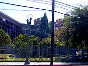
| St. Brendan St. Brendan Catholic Church, Los Angeles St. Brendan Catholic Church is a Catholic church in the Roman Catholic Archdiocese of Los Angeles, located in the Hancock Park section of Los Angeles, California. The current Gothic Revival-style church was built in 1927 and has also served as a location for various Hollywood productions.-Early... |
_edit.jpg) |
310 S. Van Ness Ave.34°04′07"N 118°18′53"W | Los Angeles Los Angeles, California Los Angeles , with a population at the 2010 United States Census of 3,792,621, is the most populous city in California, USA and the second most populous in the United States, after New York City. It has an area of , and is located in Southern California... (Koreatown Koreatown, Los Angeles, California Koreatown is a neighborhood in the Mid-Wilshire district of the city of Los Angeles, California known for its concentration of Korean American people and institutions... ) |
K-8http://www.archdiocese.la/directories/schools/info.php?school_id=159 |
| St. Bridget (Chinese)http://www.stbridgetccc.com/ | 510 Cottage Home St.34°04′08"N 118°14′08"W | Los Angeles Los Ángeles Los Ángeles is the capital of the province of Biobío, in the commune of the same name, in Region VIII , in the center-south of Chile. It is located between the Laja and Biobío rivers. The population is 123,445 inhabitants... (Chinatown) |
No | |
| St. Casimir | 2718 Saint George St.34°06′30"N 118°16′29"W | Los Angeles Los Angeles, California Los Angeles , with a population at the 2010 United States Census of 3,792,621, is the most populous city in California, USA and the second most populous in the United States, after New York City. It has an area of , and is located in Southern California... (Los Feliz Los Feliz, Los Angeles, California Los Feliz, also Rancho Los Feliz is an affluent, hilly neighborhood in the Hollywood district of Los Angeles, California, named after its land grantee José Vicente Feliz.... ) |
No | |
| St. Columban | 125 Loma Dr.34°03′45"N 118°15′49"W | Los Angeles Los Ángeles Los Ángeles is the capital of the province of Biobío, in the commune of the same name, in Region VIII , in the center-south of Chile. It is located between the Laja and Biobío rivers. The population is 123,445 inhabitants... (Filipinotown Historic Filipinotown, Los Angeles, California Historic Filipinotown is a newly created district of the city of Los Angeles, California,that makes up the southwest portion of Echo Park, Los Angeles, California . It was created by a resolution proposed by city council member Eric Garcetti on August 2, 2002... ) |
No | |
| St. Francis of Assisihttp://www.angelfire.com/la3/sfa/chomepage.html | 1523 Golden Gate Ave.34°05′23"N 118°16′33"W | Los Angeles Los Ángeles Los Ángeles is the capital of the province of Biobío, in the commune of the same name, in Region VIII , in the center-south of Chile. It is located between the Laja and Biobío rivers. The population is 123,445 inhabitants... (Silverlake) |
K-8http://www.archdiocese.la/directories/schools/info.php?school_id=187 | |
| St. Gregory Nazianzenhttp://stgregorylaschool.com/frame_history.htm | 900 S. Bronson Ave.34°03′21"N 118°19′15"W | Los Angeles Los Ángeles Los Ángeles is the capital of the province of Biobío, in the commune of the same name, in Region VIII , in the center-south of Chile. It is located between the Laja and Biobío rivers. The population is 123,445 inhabitants... (Koreatown Koreatown, Los Angeles, California Koreatown is a neighborhood in the Mid-Wilshire district of the city of Los Angeles, California known for its concentration of Korean American people and institutions... ) |
1-8http://www.archdiocese.la/directories/schools/info.php?school_id=193 | |
| St. Kevinhttp://stkevinparish.org/about_us | 4072 Beverly Blvd.34°04′34"N 118°17′53"W | Los Angeles Los Angeles, California Los Angeles , with a population at the 2010 United States Census of 3,792,621, is the most populous city in California, USA and the second most populous in the United States, after New York City. It has an area of , and is located in Southern California... (South Hollywood Hollywood, Los Angeles, California Hollywood is a famous district in Los Angeles, California, United States situated west-northwest of downtown Los Angeles. Due to its fame and cultural identity as the historical center of movie studios and movie stars, the word Hollywood is often used as a metonym of American cinema... ) |
No | |
| St. Mary Magdalenhttp://www.stmarymagdalenla.org/start/main.html | 1241 Corning St.34°03′16"N 118°22′39"W | Los Angeles Los Angeles, California Los Angeles , with a population at the 2010 United States Census of 3,792,621, is the most populous city in California, USA and the second most populous in the United States, after New York City. It has an area of , and is located in Southern California... (South Robertson South Robertson, Los Angeles, California South Robertson is a Los Angeles neighborhood south of Beverly Hills. The commercial district along Robertson is sometimes called SoRo Village. It is served by zip codes 90034 and 90035, and a local neighborhood council... ) |
1-8http://www.archdiocese.la/directories/schools/info.php?school_id=237 | |
| St. Peter (Italian)http://www.stpeterschurchla.org/ | 1039 N. Broadway34°04′04"N 118°14′06"W | Los Angeles Los Ángeles Los Ángeles is the capital of the province of Biobío, in the commune of the same name, in Region VIII , in the center-south of Chile. It is located between the Laja and Biobío rivers. The population is 123,445 inhabitants... (Solano Canyon Solano Canyon, Los Angeles, California Solano Canyon is a village-like community in Los Angeles, California completely surrounded by Elysian Park. Adjacent communities include Chinatown, Elysian Heights, Echo Park and Lincoln Heights.-External links:**... ) |
No | |
| St. Teresa of Avilahttp://www.stteresaofavilala.org/parish.php | 2215 Fargo St.34°05′31"N 118°15′32"W | Los Angeles Los Ángeles Los Ángeles is the capital of the province of Biobío, in the commune of the same name, in Region VIII , in the center-south of Chile. It is located between the Laja and Biobío rivers. The population is 123,445 inhabitants... (Silverlake) |
K-8http://www.archdiocese.la/directories/schools/info.php?school_id=269 | |
Deanery 15 (Downtown/South)
| Church name | Image | Address | Community | School |
|---|---|---|---|---|
| Cathedral of Our Lady of the Angels Cathedral of Our Lady of the Angels The Cathedral of Our Lady of the Angels, also called "COLA" and the Los Angeles Cathedral, is a cathedral of the Roman Catholic Church in Los Angeles, California, United States... |
 |
555 West Temple St.34°03′25"N 118°14′41"W | Los Angeles Los Ángeles Los Ángeles is the capital of the province of Biobío, in the commune of the same name, in Region VIII , in the center-south of Chile. It is located between the Laja and Biobío rivers. The population is 123,445 inhabitants... (Downtown) |
K-8http://www.archdiocese.la/directories/schools/info.php?school_id=20 9-12http://www.archdiocese.la/directories/schools/info.php?school_id=21 |
| Holy Cross | 4705 S. Main St.34°00′03"N 118°16′27"W | Los Angeles Los Angeles, California Los Angeles , with a population at the 2010 United States Census of 3,792,621, is the most populous city in California, USA and the second most populous in the United States, after New York City. It has an area of , and is located in Southern California... (South Los Angeles South Los Angeles South Los Angeles, often abbreviated as South L.A. and formerly South Central Los Angeles, is the official name for a large geographic and cultural portion lying to the southwest and southeast of downtown Los Angeles, California. The area was formerly called South Central, and is still widely known... ) |
No | |
| Holy Name of Jesushttp://holynameofjesus-la.org/ | 1955 W. Jefferson Blvd.34°01′32"N 118°18′53"W | Los Angeles Los Angeles, California Los Angeles , with a population at the 2010 United States Census of 3,792,621, is the most populous city in California, USA and the second most populous in the United States, after New York City. It has an area of , and is located in Southern California... (Jefferson Park Jefferson Park, Los Angeles, California -Geography and transportation:Jefferson Park's boundaries are, roughly, Western Avenue on the east, Adams on the north, Crenshaw Boulevard on the west, and Exposition Boulevard/Rodeo Road on the south. It is bordered by Arlington Heights on the north, Mid-City on the northwest, Leimert Park/King... ) |
K-8http://www.archdiocese.la/directories/schools/info.php?school_id=44 | |
| Immaculate Conception | 1433 James M. Wood Blvd.34°03′02"N 118°16′17"W | Los Angeles Los Angeles, California Los Angeles , with a population at the 2010 United States Census of 3,792,621, is the most populous city in California, USA and the second most populous in the United States, after New York City. It has an area of , and is located in Southern California... (Pico-Union) |
K-8http://www.archdiocese.la/directories/schools/info.php?school_id=51 | |
| Our Lady of the Bright Mount | 3424 W. Adams Blvd.34°01′55"N 118°19′19"W | Los Angeles Los Angeles, California Los Angeles , with a population at the 2010 United States Census of 3,792,621, is the most populous city in California, USA and the second most populous in the United States, after New York City. It has an area of , and is located in Southern California... (West Adams West Adams, Los Angeles, California West Adams, also known as Historic West Adams, is a large district located in the center of Los Angeles, California, southwest of Downtown and west of USC... ) |
No | |
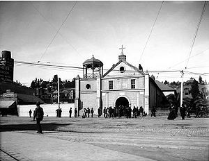
| Our Lady Queen of Angels ("La Placita") La Iglesia de Nuestra Señora Reina de los Angeles La Iglesia de Nuestra Señora la Reina de Los Angeles is a Catholic church founded on August 18, 1814 by Fray Luis Gil y Taboada, who placed the cornerstone of a new church amid the ruins of the former "sub-mission," the Nuestra Señora Reina de los Angeles Asistencia to serve the local... |
 |
535 N. Main St.34°03′25"N 118°14′25"W | Los Angeles Los Angeles, California Los Angeles , with a population at the 2010 United States Census of 3,792,621, is the most populous city in California, USA and the second most populous in the United States, after New York City. It has an area of , and is located in Southern California... (Downtown) |
No |
| Our Saviour (USC)http://www.catholictrojan.org/ | 3207 University Ave.34°01′26"N 118°17′07"W | Los Angeles Los Angeles, California Los Angeles , with a population at the 2010 United States Census of 3,792,621, is the most populous city in California, USA and the second most populous in the United States, after New York City. It has an area of , and is located in Southern California... (Expo Park Exposition Park (Los Angeles) Exposition Park is located in University Park, Los Angeles, California, across the street from the University of Southern California. Exposition Park houses the following:* Los Angeles Memorial Coliseum* Los Angeles Memorial Sports Arena... ) |
No | |
| St. Agathahttp://www.stagathas.org/ | 2646 S Mansfield Ave.34°01′51"N 118°21′09"W | Los Angeles Los Angeles, California Los Angeles , with a population at the 2010 United States Census of 3,792,621, is the most populous city in California, USA and the second most populous in the United States, after New York City. It has an area of , and is located in Southern California... (Baldwin Hills Baldwin Hills, Los Angeles, California Baldwin Hills is a community and neighborhood in the South Los Angeles area of Los Angeles, within southwestern Los Angeles County, California... ) |
No | |
| St. Agnes | 2625 S. Vermont Ave.34°01′55"N 118°17′30"W | Los Angeles Los Angeles, California Los Angeles , with a population at the 2010 United States Census of 3,792,621, is the most populous city in California, USA and the second most populous in the United States, after New York City. It has an area of , and is located in Southern California... (West Adams, Los Angeles, California West Adams, Los Angeles, California West Adams, also known as Historic West Adams, is a large district located in the center of Los Angeles, California, southwest of Downtown and west of USC... ) |
K-8http://www.archdiocese.la/directories/schools/info.php?school_id=134 | |
| St. Anthony (Croatian)http://www.croatianchurch.org/ | 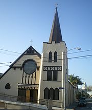 |
712 N. Grand Ave.34°03′46"N 118°14′35"W | Los Angeles Los Angeles, California Los Angeles , with a population at the 2010 United States Census of 3,792,621, is the most populous city in California, USA and the second most populous in the United States, after New York City. It has an area of , and is located in Southern California... (Downtown) |
No |
| St. Bernadettehttp://www.parishesonline.com/scripts/hostedsites/Org.asp?ID=16867 | 3825 Don Felipe Dr.34°00′28"N 118°20′33"W | Los Angeles Los Angeles, California Los Angeles , with a population at the 2010 United States Census of 3,792,621, is the most populous city in California, USA and the second most populous in the United States, after New York City. It has an area of , and is located in Southern California... (Baldwin Hills Baldwin Hills, Los Angeles, California Baldwin Hills is a community and neighborhood in the South Los Angeles area of Los Angeles, within southwestern Los Angeles County, California... ) |
K-8http://www.archdiocese.la/directories/schools/info.php?school_id=153 | |
| St. Cecilia St. Cecilia Catholic Church (Los Angeles) St. Cecilia's Catholic Church is a Roman Catholic parish in the Our Lady of the Angels Pastoral Region of the Archdiocese of Los Angeles. The church is located at 4230 South Normandie Avenue in the South Los Angeles section of Los Angeles, California USA. The Lombard Romanesque church was built in... |
4230 South Normandie Ave.34°00′20"N 118°17′59"W | Los Angeles Los Angeles, California Los Angeles , with a population at the 2010 United States Census of 3,792,621, is the most populous city in California, USA and the second most populous in the United States, after New York City. It has an area of , and is located in Southern California... (South Los Angeles South Los Angeles South Los Angeles, often abbreviated as South L.A. and formerly South Central Los Angeles, is the official name for a large geographic and cultural portion lying to the southwest and southeast of downtown Los Angeles, California. The area was formerly called South Central, and is still widely known... ) |
K-8http://www.archdiocese.la/directories/schools/info.php?school_id=165 | |
| St. Joseph | 1202 S. Los Angeles St.34°02′12"N 118°15′30"W | Los Angeles Los Angeles, California Los Angeles , with a population at the 2010 United States Census of 3,792,621, is the most populous city in California, USA and the second most populous in the United States, after New York City. It has an area of , and is located in Southern California... (Downtown) |
No | |
| St. Patrick St. Patrick Catholic Church (Los Angeles) Saint Patrick Catholic Church is a Catholic church in Los Angeles, California. It is located just east of Downtown Los Angeles and is one of the oldest parishes in Los Angeles.-History:... |
1046 E. 34th St.34°00′44"N 118°15′24"W | Los Angeles Los Angeles, California Los Angeles , with a population at the 2010 United States Census of 3,792,621, is the most populous city in California, USA and the second most populous in the United States, after New York City. It has an area of , and is located in Southern California... (South Central) |
No | |
| St. Paul | 1920 South Bronson Ave.34°02′20"N 118°19′47"W | Los Angeles Los Angeles, California Los Angeles , with a population at the 2010 United States Census of 3,792,621, is the most populous city in California, USA and the second most populous in the United States, after New York City. It has an area of , and is located in Southern California... (Mid-City Mid-City, Los Angeles, California Mid-City is a district in Los Angeles, California. It is 2.5 miles south of Hollywood and 3.5 miles west of downtown Los Angeles. The Lafayette Square, Victoria Park, Wellington Square, and Vineyard neighborhoods are part of the district.-Geography and history:Mid-City's boundaries are roughly... ) |
1-8http://www.archdiocese.la/directories/schools/info.php?school_id=251 | |
| St. Stephenhttp://www.saintstephencatholic.org/ | 3705 Woodlawn Ave.34°00′52"N 118°16′23"W | Los Angeles Los Angeles, California Los Angeles , with a population at the 2010 United States Census of 3,792,621, is the most populous city in California, USA and the second most populous in the United States, after New York City. It has an area of , and is located in Southern California... (South Central) |
No | |
| St. Thomas the Apostle St. Thomas the Apostle Catholic Church (Los Angeles) St. Thomas the Apostle Catholic Church is a Roman Catholic church and parish in the Los Angeles Archdiocese, Our Lady of the Angels Pastoral Region. The church faces Pico Boulevard at 1321 S. Mariposa Avenue in the Pico Union section of Los Angeles, California... |
 |
1321 S. Mariposa Ave.34°02′48"N 118°17′56"W | Los Angeles Los Angeles, California Los Angeles , with a population at the 2010 United States Census of 3,792,621, is the most populous city in California, USA and the second most populous in the United States, after New York City. It has an area of , and is located in Southern California... (Pico-Union Pico-Union, Los Angeles, California Pico-Union is a district in Los Angeles, California. Its name derives from the intersection of Pico Boulevard and Union Avenue. The Los Angeles Community Redevelopment Agency officially adopted the name in 1970, when it launched a neighborhood renewal program that continues to this day... ) |
K-8http://www.archdiocese.la/directories/schools/info.php?school_id=273 |
| St. Vincent St. Vincent de Paul Church (Los Angeles, California) St. Vincent de Paul Church is a Roman Catholic parish and Los Angeles Historic-Cultural Monument in the West Adams section of Los Angeles, California. The church was built in the 1920s and designed by architect Albert C. Martin, Sr... |
 |
621 West Adams Blvd.34°01′43"N 118°16′34"W | Los Angeles Los Angeles, California Los Angeles , with a population at the 2010 United States Census of 3,792,621, is the most populous city in California, USA and the second most populous in the United States, after New York City. It has an area of , and is located in Southern California... (West Adams West Adams, Los Angeles, California West Adams, also known as Historic West Adams, is a large district located in the center of Los Angeles, California, southwest of Downtown and west of USC... ) |
K-8http://www.archdiocese.la/directories/schools/info.php?school_id=276 |
| Transfiguration | 2515 W. Martin Luther King Blvd.34°00′39"N 118°19′16"W | Los Angeles Los Angeles, California Los Angeles , with a population at the 2010 United States Census of 3,792,621, is the most populous city in California, USA and the second most populous in the United States, after New York City. It has an area of , and is located in Southern California... (Leimert Park Leimert Park, Los Angeles, California Leimert Park is a neighborhood in Los Angeles, California roughly bounded by Rodeo Road on the north, 4th Avenue and Roxton Avenue on the east, Vernon Avenue on the south, and Crenshaw Boulevard on the west. Crenshaw District lies to the south, View Park to the west, Vermont Square to the east,... ) |
K-8http://www.archdiocese.la/directories/schools/info.php?school_id=277 | |
Deanery 16 (South LA/Inglewood)
| Church name | Image | Address | Community | School |
|---|---|---|---|---|
| Ascensionhttp://www.ascensionla.org/ | 517 West 112th St.33°55′59"N 118°16′59"W | Athens Athens, California Athens is an unincorporated community in Los Angeles County, California. It lies at an elevation of 171 feet . Athens is located in the South Los Angeles region, near the intersection of the Century and the Harbor freeways... (unincorporated Los Angeles) |
K-8http://www.archdiocese.la/directories/schools/info.php?school_id=7 | |
| Mother of Sorrows | 114 West 87th St.33°57′30"N 118°16′28"W | Los Angeles Los Angeles, California Los Angeles , with a population at the 2010 United States Census of 3,792,621, is the most populous city in California, USA and the second most populous in the United States, after New York City. It has an area of , and is located in Southern California... (South Los Angeles South Los Angeles South Los Angeles, often abbreviated as South L.A. and formerly South Central Los Angeles, is the official name for a large geographic and cultural portion lying to the southwest and southeast of downtown Los Angeles, California. The area was formerly called South Central, and is still widely known... ) |
K-8http://www.archdiocese.la/directories/schools/info.php?school_id=72 | |
| Nativity | 953 West 57th St.33°59′26"N 118°17′27"W | Los Angeles Los Angeles, California Los Angeles , with a population at the 2010 United States Census of 3,792,621, is the most populous city in California, USA and the second most populous in the United States, after New York City. It has an area of , and is located in Southern California... (South Los Angeles South Los Angeles South Los Angeles, often abbreviated as South L.A. and formerly South Central Los Angeles, is the official name for a large geographic and cultural portion lying to the southwest and southeast of downtown Los Angeles, California. The area was formerly called South Central, and is still widely known... ) |
K-8http://www.archdiocese.la/directories/schools/info.php?school_id=75 | |
| Presentation of Mary | 6406 Parmelee Ave.33°58′51"N 118°14′58"W | Florence Florence, California Florence is an unincorporated community in California. It is often considered part of South Los Angeles despite being outside of the Los Angeles city limits. It is serviced by area code 323 and has a ZIP code of 90001... (unincorporated Los Angeles) |
No | |
| St. Anselm | 2222 West 70th St.33°58′34"N 118°19′06"W | Los Angeles Los Angeles, California Los Angeles , with a population at the 2010 United States Census of 3,792,621, is the most populous city in California, USA and the second most populous in the United States, after New York City. It has an area of , and is located in Southern California... (Hyde Park Hyde Park, Los Angeles, California -History:Hyde Park is one of the oldest neighborhoods in the city of Los Angeles. It was established in 1887 as a stop on the Atchison, Topeka and Santa Fe Railway's Harbor Subdivision, which ran from Downtown Los Angeles to the port at Wilmington in a westward loop.It was incorporated as a city... |
K-8http://www.archdiocese.la/directories/schools/info.php?school_id=141 | |
| St. Brigid | 5214 South Western Ave.33°59′40"N 118°18′31"W | Los Angeles Los Angeles, California Los Angeles , with a population at the 2010 United States Census of 3,792,621, is the most populous city in California, USA and the second most populous in the United States, after New York City. It has an area of , and is located in Southern California... (Crenshaw Crenshaw, Los Angeles, California Crenshaw is a neighborhood and district in southwestern Los Angeles, California. It derives its name from Crenshaw Boulevard, one of the city's principal thoroughfares.... ) |
No | |
| St. Columbkille | 6315 South Main St.33°58′54"N 118°16′27"W | Los Angeles Los Angeles, California Los Angeles , with a population at the 2010 United States Census of 3,792,621, is the most populous city in California, USA and the second most populous in the United States, after New York City. It has an area of , and is located in Southern California... (South Los Angeles South Los Angeles South Los Angeles, often abbreviated as South L.A. and formerly South Central Los Angeles, is the official name for a large geographic and cultural portion lying to the southwest and southeast of downtown Los Angeles, California. The area was formerly called South Central, and is still widely known... ) |
K-8http://www.archdiocese.la/directories/schools/info.php?school_id=168 | |
| St. Eugene | 9505 Haas Ave.33°57′00"N 118°19′00"W | Westmont Westmont, California Westmont is a census-designated place in Los Angeles County, California, United States. The population was 31,853 at the 2010 census, up from 31,623 at the 2000 census... (unincorporated Los Angeles) |
K-8http://www.archdiocese.la/directories/schools/info.php?school_id=179 | |
| St. Frances X. Cabrini | 1440 West Imperial Hwy.33°55′49"N 118°18′06"W | Athens Athens, California Athens is an unincorporated community in Los Angeles County, California. It lies at an elevation of 171 feet . Athens is located in the South Los Angeles region, near the intersection of the Century and the Harbor freeways... (unincorporated Los Angeles) |
K-8http://www.archdiocese.la/directories/schools/info.php?school_id=184 | |
| St. John Chrysostom | 546 East Florence Ave.33°58′10"N 118°20′51"W | Inglewood Inglewood, California Inglewood is a city in southwestern Los Angeles County, California, southwest of downtown Los Angeles. It was incorporated on February 14, 1908. Its population stood at 109,673 as of the 2010 Census... |
K-8http://www.archdiocese.la/directories/schools/info.php?school_id=204 | |
| St. John the Evangelisthttp://johnevangelist.org/ | 6028 Victoria Ave.33°59′05"N 118°19′55"W | Los Angeles Los Angeles, California Los Angeles , with a population at the 2010 United States Census of 3,792,621, is the most populous city in California, USA and the second most populous in the United States, after New York City. It has an area of , and is located in Southern California... (Hyde Park Hyde Park, Los Angeles, California -History:Hyde Park is one of the oldest neighborhoods in the city of Los Angeles. It was established in 1887 as a stop on the Atchison, Topeka and Santa Fe Railway's Harbor Subdivision, which ran from Downtown Los Angeles to the port at Wilmington in a westward loop.It was incorporated as a city... ) |
K-8http://www.archdiocese.la/directories/schools/info.php?school_id=209 | |
| St. Lawrence of Brindisi | 10122 Compton Ave.33°56′40"N 118°14′45"W | Los Angeles Los Angeles, California Los Angeles , with a population at the 2010 United States Census of 3,792,621, is the most populous city in California, USA and the second most populous in the United States, after New York City. It has an area of , and is located in Southern California... (Watts Watts, Los Angeles, California Watts is a mostly residential neighborhood in South Los Angeles, California.-History:The area now known as Watts is located on the Rancho La Tajauta Mexican land grant... ) |
K-8http://www.archdiocese.la/directories/schools/info.php?school_id=217 | |
| St. Malachy | 1221 East 82nd St.33°57′53"N 118°15′11"W | Graham Florence-Graham, California Florence-Graham is a census-designated place in Los Angeles County, California, United States. The population was 63,387 at the 2010 census, up from 60,197 at the 2000 census... (Unincorporated Los Angeles) |
K-8http://www.archdiocese.la/directories/schools/info.php?school_id=227 | |
| St. Michael | 1016 West Manchester Ave.33°57′34"N 118°17′34"W | Los Angeles Los Angeles, California Los Angeles , with a population at the 2010 United States Census of 3,792,621, is the most populous city in California, USA and the second most populous in the United States, after New York City. It has an area of , and is located in Southern California... (Vermont Knolls Vermont Knolls, Los Angeles, California Vermont Knolls is a district in Los Angeles. Vermont Knolls is a Black majority district with a large Latino population. The neighborhood is roughly 65% Black and the rest being mainly Latino.-External links:*... ) |
K-8http://www.archdiocese.la/directories/schools/info.php?school_id=244 | |
| St. Odilia | 5222 Hooper Ave.33°59′43"N 118°15′06"W | Los Angeles Los Angeles, California Los Angeles , with a population at the 2010 United States Census of 3,792,621, is the most populous city in California, USA and the second most populous in the United States, after New York City. It has an area of , and is located in Southern California... (South Los Angeles South Los Angeles South Los Angeles, often abbreviated as South L.A. and formerly South Central Los Angeles, is the official name for a large geographic and cultural portion lying to the southwest and southeast of downtown Los Angeles, California. The area was formerly called South Central, and is still widely known... ) |
K-8http://www.archdiocese.la/directories/schools/info.php?school_id=247 | |
| St. Raphaelhttp://www.saintraphaelschool.com/ | 942 West 70th St.33°58′34"N 118°17′26"W | Los Angeles Los Angeles, California Los Angeles , with a population at the 2010 United States Census of 3,792,621, is the most populous city in California, USA and the second most populous in the United States, after New York City. It has an area of , and is located in Southern California... (South Los Angeles South Los Angeles South Los Angeles, often abbreviated as South L.A. and formerly South Central Los Angeles, is the official name for a large geographic and cultural portion lying to the southwest and southeast of downtown Los Angeles, California. The area was formerly called South Central, and is still widely known... ) |
K-8http://www.archdiocese.la/directories/schools/info.php?school_id=259 | |
Spanish Mission
Note: This is not a Spanish MissionSpanish missions in California
The Spanish missions in California comprise a series of religious and military outposts established by Spanish Catholics of the Franciscan Order between 1769 and 1823 to spread the Christian faith among the local Native Americans. The missions represented the first major effort by Europeans to...
, but rather, a parish church.
| Name | Image | Address | Community |
|---|---|---|---|
| La Iglesia de Nuestra Señora Reina de los Angeles La Iglesia de Nuestra Señora Reina de los Angeles La Iglesia de Nuestra Señora la Reina de Los Angeles is a Catholic church founded on August 18, 1814 by Fray Luis Gil y Taboada, who placed the cornerstone of a new church amid the ruins of the former "sub-mission," the Nuestra Señora Reina de los Angeles Asistencia to serve the local... |
 |
Los Angeles Los Angeles, California Los Angeles , with a population at the 2010 United States Census of 3,792,621, is the most populous city in California, USA and the second most populous in the United States, after New York City. It has an area of , and is located in Southern California... |
|
Universities and Colleges
| School name | Image | Address | Community |
|---|---|---|---|
| Loyola Marymount University Loyola Marymount University Loyola Marymount University is a comprehensive co-educational private Roman Catholic university in the Jesuit and Marymount traditions located in Los Angeles, California, United States... |
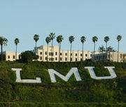 |
Westchester Westchester, Los Angeles, California Westchester is a suburban neighborhood in western Los Angeles, California, United States. It is home to Los Angeles International Airport , Loyola Marymount University , and Otis College of Art and Design.-Geography:... |
|
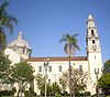
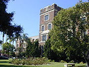
| Mount St. Mary's College Mount St. Mary's College Mount St. Mary's College is a private, independent, Catholic liberal arts college, primarily for women, in Los Angeles, California. The college was founded in 1925 by the Sisters of St... |
 |
Los Angeles Los Angeles, California Los Angeles , with a population at the 2010 United States Census of 3,792,621, is the most populous city in California, USA and the second most populous in the United States, after New York City. It has an area of , and is located in Southern California... |
|
High schools
| School name | Image | Address | Community |
|---|---|---|---|
| Bishop Conaty-Our Lady of Loretto High School Bishop Conaty-Our Lady of Loretto High School Bishop Conaty-Our Lady of Loretto High School is a Catholic, archdiocesan, all-female high school located in the Harvard Heights neighborhood of Los Angeles, California... (Girls) |
 |
2900 W. Pico Blvd.34°02′47"N 118°18′11"W | Harvard Heights Harvard Heights, Los Angeles, California Harvard Heights is a district in the Mid-Wilshire region of Los Angeles, California.-Geography and transportation:The boundaries of Harvard Heights are Pico Boulevard on the north, Western Avenue on the west, The Santa Monica freeway on the south, and Normandie Avenue on the east... |
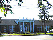
| Cathedral High School Cathedral High School (Los Angeles, California) Cathedral High School is a private, college preparatory Catholic all-boys school in Los Angeles, California.-History and background:Cathedral High School was founded by Archbishop John Joseph Cantwell as the first Los Angeles Archdiocesan high school for boys in Fall 1925. The Christian Brothers... (Boys) |
 |
1253 Bishops Rd.34°04′12"N 118°14′04"W | Los Angeles Los Angeles, California Los Angeles , with a population at the 2010 United States Census of 3,792,621, is the most populous city in California, USA and the second most populous in the United States, after New York City. It has an area of , and is located in Southern California... |
| Immaculate Heart High School Immaculate Heart High School (Los Angeles) Immaculate Heart High School is a Catholic, all-girl, college preparatory school located in the Los Feliz neighborhood in Los Angeles, California, at the intersection of Franklin Avenue and Western Avenue. There are 200 students in the middle school and 521 in the high school . It is located in... (Girls) |
5515 Franklin Ave.34°06′24"N 118°18′38"W | Los Feliz Los Feliz, Los Angeles, California Los Feliz, also Rancho Los Feliz is an affluent, hilly neighborhood in the Hollywood district of Los Angeles, California, named after its land grantee José Vicente Feliz.... |
|
| Loyola High School Loyola High School (Los Angeles) Loyola High School of Los Angeles is a Jesuit preparatory school for young men. It is the oldest high school in Southern California, and one of the oldest in California... (Boys) |
 |
1901 Venice Blvd.34°02′41"N 118°17′47"W | Harvard Heights Harvard Heights, Los Angeles, California Harvard Heights is a district in the Mid-Wilshire region of Los Angeles, California.-Geography and transportation:The boundaries of Harvard Heights are Pico Boulevard on the north, Western Avenue on the west, The Santa Monica freeway on the south, and Normandie Avenue on the east... |
| Marymount High School Marymount High School Marymount High School is a private, Roman Catholic, all-girls, college-preparatory high school located in the Holmby Hills/Bel Air neighborhood of Los Angeles. It sits across from the University of California, Los Angeles campus at 10643 Sunset Boulevard.... (Girls) |
10643 Sunset Blvd.34°04′31"N 118°26′42"W | Bel Air | |
| Notre Dame Academy Notre Dame Academy (Los Angeles, California) Notre Dame Academy Girls' High School is a private, all-girls Catholic High School located in West Los Angeles, California. Part of the Roman Catholic Archdiocese of Los Angeles, it was founded in 1949 by the Sisters of Notre Dame.-Academics:... (Girls) |
 |
2851 Overland Ave.34°02′00"N 118°25′07"W | Los Angeles Los Angeles, California Los Angeles , with a population at the 2010 United States Census of 3,792,621, is the most populous city in California, USA and the second most populous in the United States, after New York City. It has an area of , and is located in Southern California... |
| St. Bernard High School St. Bernard High School (Los Angeles, California) St. Bernard High School is a four-year coeducational Catholic high school located in Playa Del Rey, California, which is in the West Los Angeles area... |
9100 Falmouth Ave.33°57′15"N 118°25′57"W | Playa del Rey Playa del Rey, Los Angeles, California Playa del Rey is a beachside community within the city of Los Angeles, California. It has a ZIP code of 90293 and area codes of 310 and 424... |
|
| St. Mary's Academy St. Mary's Academy (Inglewood, California) St. Mary's Academy is a Roman Catholic high school for girls located within the city of Inglewood, California, United States.-Background:St. Mary's was established in 1889 by the Sisters of Saint Joseph of Carondelet.-External links:*... (Girls) |
701 Grace Ave.33°58′07"N 118°20′43"W | Inglewood Inglewood, California Inglewood is a city in southwestern Los Angeles County, California, southwest of downtown Los Angeles. It was incorporated on February 14, 1908. Its population stood at 109,673 as of the 2010 Census... |
|
| St. Monica Catholic High School Saint Monica Catholic High School Saint Monica Catholic High School is a parochial, co-educational, secondary school in Santa Monica, California, consisting of students in grades 9-12... |
1030 Lincoln Blvd.34°01′26"N 118°29′49"W | Santa Monica Santa Monica, California Santa Monica is a beachfront city in western Los Angeles County, California, US. Situated on Santa Monica Bay, it is surrounded on three sides by the city of Los Angeles — Pacific Palisades on the northwest, Brentwood on the north, West Los Angeles on the northeast, Mar Vista on the east, and... |
|
| Verbum Dei High School Verbum Dei High School Verbum Dei High School, colloquially referred to as "the Verb", is an all-male Catholic high school combining college-preparatory academic courses and immersion in corporate work environments. It is operated by the Roman Catholic Archdiocese of Los Angeles with the sponsorship of the of the... (Boys) |
11100 S. Central Ave.33°56′04"N 118°15′14"W | Watts Watts, Los Angeles, California Watts is a mostly residential neighborhood in South Los Angeles, California.-History:The area now known as Watts is located on the Rancho La Tajauta Mexican land grant... |
|
Daniel Murphy High School
Daniel Murphy High School
Daniel Murphy High School was a Roman Catholic all-boys high school located in Los Angeles, California. It was located in the Roman Catholic Archdiocese of Los Angeles.-History:...
, located at 241 S. Detroit St., Los Angeles, closed in 2008.
Elementary schools
Parish-affiliated elementary schools are noted above in the charts listing parishes. In addition to parish-affiliated elementary schools, there is several non-affiliated elementary or middle school in the Our Lady of the Angels Pastoral Region.- Cathedral Chapel, 755 S. Cochran Ave., Los Angeles
- Immaculate Heart Middle SchoolImmaculate Heart High School (Los Angeles)Immaculate Heart High School is a Catholic, all-girl, college preparatory school located in the Los Feliz neighborhood in Los Angeles, California, at the intersection of Franklin Avenue and Western Avenue. There are 200 students in the middle school and 521 in the high school . It is located in...
, 5515 Franklin Ave., Los Angeles - Notre Dame Academy ElementaryNotre Dame Academy (Los Angeles, California)Notre Dame Academy Girls' High School is a private, all-girls Catholic High School located in West Los Angeles, California. Part of the Roman Catholic Archdiocese of Los Angeles, it was founded in 1949 by the Sisters of Notre Dame.-Academics:...
, 2911 Overland Ave., Los Angeles - St. Turibius, 1524 Essex St., Los Angeles
Hospitals
- St. John's Health Center, 1328 Twenty-Second Street, Santa MonicaSanta Monica, CaliforniaSanta Monica is a beachfront city in western Los Angeles County, California, US. Situated on Santa Monica Bay, it is surrounded on three sides by the city of Los Angeles — Pacific Palisades on the northwest, Brentwood on the north, West Los Angeles on the northeast, Mar Vista on the east, and...
- St. Vincent Medical Center
Cemeteries
- Crypt Mausoleum of the Cathedral of Our Lady of the AngelsCathedral of Our Lady of the AngelsThe Cathedral of Our Lady of the Angels, also called "COLA" and the Los Angeles Cathedral, is a cathedral of the Roman Catholic Church in Los Angeles, California, United States...
, Los AngelesLos Angeles, CaliforniaLos Angeles , with a population at the 2010 United States Census of 3,792,621, is the most populous city in California, USA and the second most populous in the United States, after New York City. It has an area of , and is located in Southern California... - Holy Cross CemeteryHoly Cross Cemetery, Culver CityHoly Cross Cemetery is a Roman Catholic cemetery at 5835 West Slauson Avenue in Culver City, California, operated by the Roman Catholic Archdiocese of Los Angeles....
, Culver CityCulver City, CaliforniaCulver City is a city in western Los Angeles County, California. As of the 2010 census, the city had a population of 38,883, up from 38,816 at the 2000 census. It is mostly surrounded by the city of Los Angeles, but also shares a border with unincorporated areas of Los Angeles County. Culver...
See also
Roman Catholic Archdiocese of Los AngelesRoman Catholic Archdiocese of Los Angeles
The Archdiocese of Los Angeles is an archdiocese of the Roman Catholic Church in the U.S. state of California. Headquartered in Los Angeles, the archdiocese comprises the California counties of Los Angeles, Santa Barbara and Ventura. The diocesan cathedral is the Cathedral of Our Lady of the...
- San Fernando Pastoral RegionSan Fernando Pastoral RegionThe San Fernando Pastoral Region is a pastoral region of the Archdiocese of Los Angeles in the Roman Catholic Church. It covers the San Fernando, Santa Clarita, and Antelope Valleys. The current regional auxiliary bishop is Bishop Gerald E. Wilkerson...
- San Gabriel Pastoral RegionSan Gabriel Pastoral RegionThe San Gabriel Pastoral Region is a pastoral region of the Archdiocese of Los Angeles in the Roman Catholic Church. It covers East Los Angeles through the San Gabriel and Pomona valleys. The current regional auxiliary bishop is Bishop Gabino Zavala...
- San Pedro Pastoral RegionSan Pedro Pastoral RegionThe San Pedro Pastoral Region is a pastoral region of the Archdiocese of Los Angeles in the Roman Catholic Church. It covers Long Beach and southern Los Angeles County. The current regional auxiliary bishop is Bishop Oscar A. Solis...
- Santa Barbara Pastoral RegionSanta Barbara Pastoral RegionThe Santa Barbara Pastoral Region is a pastoral region of the Archdiocese of Los Angeles in the Roman Catholic Church. It covers Santa Barbara and Ventura counties in the state of California, USA. The current regional auxiliary bishop is Bishop Thomas J. Curry...
List of schools in the Roman Catholic Archdiocese of Los Angeles