

Altadena, California
Encyclopedia
Altadena is an unincorporated
area and census-designated place
in Los Angeles County
, California
, United States
, approximately 14 miles (22.5 km) from the downtown Los Angeles
Civic Center, and directly north of the city of Pasadena, California
. The population was 42,777 at the 2010 census, up from 42,610 at the 2000 census.
and Eaton Canyon
from the mid-1860s from his vineyard near the edge of Eaton Canyon. This made development of Altadena, Pasadena, and South Pasadena possible. He did the work for B.D. Wilson and Dr. John Griffin, who jointly owned the Mexican land grant of the Rancho San Pascual
, about 14000 acres (56.7 km²) that comprised the future sites of the three communities. They hoped to develop and sell part of this in a real estate scheme called the San Pasqual Plantation. It failed by 1870 despite the irrigation ditch Eaton engineered for the partners that drew water from around the site of present day Jet Propulsion Laboratory
in the Arroyo Seco. The failure had two main causes: few believed citrus or other crops could thrive so close to the mountains, and the land was relatively inaccessible.
Eaton then tried to sell the land for the partners, and in late 1873 helped broker a deal with Daniel Berry, who represented a group of investors from Indiana to purchase 4000 acres (16.2 km²) of the rancho. Although this included the land of present day Altadena, they developed the 2500 acres (10.1 km²) section further south into Pasadena. In 1881, the land that became Altadena was sold to the Woodbury brothers, John and Fred, who launched the subdivision of Altadena in 1887 just as Southern California's great land boom busted. The land remained mostly agricultural. However, several millionaires (mainly from Chicago) built mansions along Mariposa Street, and a small community slowly developed through the 1890s and into the new century.
In 1880, Capt. Frederick Woodbury and his brother John Woodbury of Marshalltown, Iowa
, purchased 937 acres (3.8 km²) known as the Woodbury Ranch. John Woodbury established the Pasadena Improvement Company in 1887 with a plot plan of residential development referred to as the Woodbury Subdivision. They contacted Byron O. Clark who established a nursery in the foothills in 1875 and had since moved away. He called his nursery "Altadena Nursery", a name he coined from the Spanish "alta" meaning "upper" and "dena" from Pasadena. Woodbury asked if he could use the name "Altadena" for his subdivision and Clark agreed.
The newly sprouted community of Altadena immediately began to attract millionaires from the East. In 1887 Andrew McNally
, the printing magnate from Chicago and his good friend Col. G. G. Green
had built mansions on what was to become Millionaire's Row, Mariposa Street near Santa Rosa. Newspaper moguls William Armiger Scripps and William Kellogg built side by side just east of Fair Oaks Avenue. The grandson of Andrew McNally, Wallace Neff
, became a famous Southern California architect. He started his career in Altadena with the design and construction of St. Elizabeth of Hungary Catholic Church ( parish est.1918) which was dedicated in October 1926.
Over the years Altadena has been subject to attempted annexation by Pasadena. Annexation was stopped in 1956 by community campaigns though it has been resurrected several times since by Pasadena without success. Had the annexation succeeded, Pasadena would be the 108th largest city in the United States.
While Altadena long refused wholesale annexation by neighboring Pasadena
, the larger community nibbled at its edges in several small annexations of neighborhoods through the 1940s. With early 1960s redevelopment in Pasadena, the routing of extensions of 134 and 210 freeways, and lawsuits over the desegregation of Pasadena Unified School District, there was white flight and convulsive racial change in Altadena. In 1960, its black population was under four percent; over the next 15 years, half the Caucasian population left and was replaced by people of color — many of whom settled on the west side of town after being displaced by Pasadena's redevelopment and freeway projects.
The name Altadena derives from the Spanish
alta, meaning "upper", and dena from Pasadena; the area is adjacent to, but at a higher elevation than, Pasadena.
, the CDP has a total area of 8.7 square miles (22.5 km²), over 99% of it land.
was 4,900.4 people per square mile (1,892.1/km²). The racial makeup of Altadena was 22,569 (52.8%) White, 10,136 (23.7%) African American, 300 (0.7%) Native American, 2,307 (5.4%) Asian, 71 (0.2%) Pacific Islander, 4,852 (11.3%) from other races
, and 2,542 (5.9%) from two or more races. Hispanic or Latino of any race were 11,502 persons (26.9%).
The Census reported that 42,276 people (98.8% of the population) lived in households, 234 (0.5%) lived in non-institutionalized group quarters, and 267 (0.6%) were institutionalized.
There were 15,212 households, out of which 5,170 (34.0%) had children under the age of 18 living in them, 7,684 (50.5%) were opposite-sex married couples
living together, 2,210 (14.5%) had a female householder with no husband present, 814 (5.4%) had a male householder with no wife present. There were 661 (4.3%) unmarried opposite-sex partnerships
, and 271 (1.8%) same-sex married couples or partnerships. 3,489 households (22.9%) were made up of individuals and 1,318 (8.7%) had someone living alone who was 65 years of age or older. The average household size was 2.78. There were 10,708 families
(70.4% of all households); the average family size was 3.26.
The population was spread out with 9,507 people (22.2%) under the age of 18, 3,286 people (7.7%) aged 18 to 24, 10,622 people (24.8%) aged 25 to 44, 13,298 people (31.1%) aged 45 to 64, and 6,064 people (14.2%) who were 65 years of age or older. The median age was 41.8 years. For every 100 females there were 93.1 males. For every 100 females age 18 and over, there were 89.2 males.
There were 15,947 housing units at an average density of 1,826.8 per square mile (705.4/km²), of which 10,889 (71.6%) were owner-occupied, and 4,323 (28.4%) were occupied by renters. The homeowner vacancy rate was 0.9%; the rental vacancy rate was 4.9%. 30,319 people (70.9% of the population) lived in owner-occupied housing units and 11,957 people (28.0%) lived in rental housing units.
of 2000, there were 42,610 people, 14,780 households, and 10,671 families residing in the CDP. The population density
was 4,898.9 people per square mile (1,891.0/km²). There were 15,250 housing units at an average density of 1,753.3 per square mile (676.8/km²). The racial makeup of the CDP was 47.30% White
, 31.42% Black
or African American
, 0.58% Native American
, 4.24% Asian
, 0.13% Pacific Islander
, 10.19% from other races
, and 6.14% from two or more races. 20.39% of the population were Hispanic or Latino
of any race.
There were 14,780 households out of which 34.1% had children under the age of 18 living with them, 52.3% were married couples
living together, 15.2% had a female householder with no husband present, and 27.8% were non-families. 21.8% of all households were made up of individuals and 7.1% had someone living alone who was 65 years of age or older. The average household size was 2.82 and the average family size was 3.29.
In the CDP the population was spread out with 26.6% under the age of 18, 6.4% from 18 to 24, 30.1% from 25 to 44, 24.6% from 45 to 64, and 12.3% who were 65 years of age or older. The median age was 38 years. For every 100 females there were 91.8 males. For every 100 females age 18 and over, there were 86.6 males.
The median income for a household in the CDP was $60,549, and the median income for a family was $66,800 (these figures had risen to $77,020 and $86,778 respectively as of a 2007 estimate). Males had a median income of $49,098 versus $38,054 for females. The per capita income
for the CDP was $27,604. About 7.4% of families and 10.6% of the population were below the poverty line, including 14.1% of those under age 18 and 8.3% of those age 65 or over.
. In 1975, a group of Altadenans formed The Altadena Town Council with the help of Los Angeles County Supervisor Baxter Ward
and the Pasadena Chapter of the League of Women Voters
.
The Altadena Town Council acts as an ombudsman
group to express to county, state and federal agencies the will and wishes of the Altadena community. Altadena is identified collectively by eight census tract, (U.S. Census Bureau) from each of which two resident census tract representatives are elected. The Altadena Town Council meets monthly at the Altadena Community Center to provide a forum for residents and government officials to convene. The council has no legislative powers and makes no legal decisions for the community; it only operates to express consensus to governmental officials.
Altadena is located in the 21st Senate
District, represented by Democrat Carol Liu
, and in the 44th Assembly
District, represented by Democrat Anthony J. Portantino
. Federally, Altadena is located in California's 26th
and 29th
congressional districts, which have Cook PVIs
of R +4 and D +12 respectively and are represented by Republican David Dreier
and Democrat Adam Schiff
respectively.
(LASD) operates the Altadena Station in Altadena.
The Los Angeles County Department of Health Services
operates the Monrovia Health Center in Monrovia
, serving Altadena.
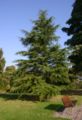
 Official tree: The Deodar Cedar
(Cedrus deodara). Indigenous to the Himalayas, the deodar was brought as seeds to Altadena in 1883 by Founder John Woodbury who saw the beautiful trees in Italy. After growing the trees for two years, the trees were transplanted to Santa Rosa Avenue where they now stand majestically as Christmas Tree Lane
.
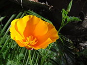
Official flower: The California Golden Poppy
(Eschscholzia californica). Indigenous to the southland, the golden poppy was a landmark to Spanish sailors who recognized the area by a sweeping gold carpet. The sailors referred to the marvelous vision as sabanilla de oro, or, "altar cloth of gold."
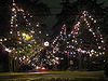 Christmas Tree Lane
is a 0.7 miles (1.1 km) stretch of Santa Rosa Avenue from Woodbury Road to Altadena Drive
. It has been a holiday attraction since 1920 and it is the oldest large-scale outdoor Christmas lighting venue in the world. Each December, members of the Christmas Tree Lane Association http://www.christmastreelane.net/ festoon the 110 still standing giant deodars
that line the street with thousands of Christmas lights. Christmas Tree Lane was placed on the National Register of Historic Places
in 1990, and is a California Historical Landmark
.
Among Altadena's Christmas lighting attractions is the Balian Mansion, which collects worldwide tours for its Christmas lighting display. The Balian Mansion has been lighted since 1955 and is arguably the pioneer of home holiday lighting. The Balian Mansion is located at the 5-point junction of Mendocino Street, Mendocino Lane, Allen Avenue, and East Glenview Terrace.
The historic Mount Lowe Railway
was once a scenic railway that carried passengers to any four resort hotels high in the San Gabriel Mountains above Altadena and Pasadena. Although the mountains and the remains of the railway are not strictly in Altadena, the most direct trail to the sites, the Sam Merrill Trail
, starts in Altadena at the top of Lake Avenue
and leads to Mount Echo, about 3 miles (4.8 km). Chaney Trail, just west of the intersection at Fair Oaks Avenue and Loma Alta Street, is a forestry service road leading to the old right of way. The Mount Lowe Railway was placed on the National Register of Historic Places
in 1993.
The Cobb Estate at the top of Lake Avenue is now a free botanical garden
of the United States Forest Service
. It is guarded by its historic gates which are easily bypassed to allow visitors and hikers to ascend its long and winding paved driveway to the site of what was once one of Altadena's premier mansions. This is found alongside the Sam Merrill Trail which accesses Las Flores Canyon on the way to Echo Mountain
.
Farnsworth Park located on Lake Avenue is a large county park that offers picnic grounds, play areas, and a club house and amphitheater. It was placed in the National Register of Historic Places in 1997.
schools. Zoned elementary schools include Altadena Elementary School, Burbank Elementary School, Edison Elementary School, Franklin Elementary School, Jackson Elementary School, Loma Alta Elementary School, Webster Elementary School, Aveson School of Leaders, Eliot Middle School, Muir High School
, Pasadena High School, John Marshall Fundamental
and Blair High School.
Private schools include Sahag-Mesrob Armenian Christian School, St. Elizabeth Catholic School, Saint Mark's, Pasadena Waldorf School, Walden School and Jane Warner's School
Unincorporated area
In law, an unincorporated area is a region of land that is not a part of any municipality.To "incorporate" in this context means to form a municipal corporation, a city, town, or village with its own government. An unincorporated community is usually not subject to or taxed by a municipal government...
area and census-designated place
Census-designated place
A census-designated place is a concentration of population identified by the United States Census Bureau for statistical purposes. CDPs are delineated for each decennial census as the statistical counterparts of incorporated places such as cities, towns and villages...
in Los Angeles County
Los Angeles County, California
Los Angeles County is a county in the U.S. state of California. As of 2010 U.S. Census, the county had a population of 9,818,605, making it the most populous county in the United States. Los Angeles County alone is more populous than 42 individual U.S. states...
, California
California
California is a state located on the West Coast of the United States. It is by far the most populous U.S. state, and the third-largest by land area...
, United States
United States
The United States of America is a federal constitutional republic comprising fifty states and a federal district...
, approximately 14 miles (22.5 km) from the downtown Los Angeles
Downtown Los Angeles
Downtown Los Angeles is the central business district of Los Angeles, California, United States, located close to the geographic center of the metropolitan area...
Civic Center, and directly north of the city of Pasadena, California
Pasadena, California
Pasadena is a city in Los Angeles County, California, United States. Although famous for hosting the annual Rose Bowl football game and Tournament of Roses Parade, Pasadena is the home to many scientific and cultural institutions, including the California Institute of Technology , the Jet...
. The population was 42,777 at the 2010 census, up from 42,610 at the 2000 census.
History
Benjamin Eaton first developed water sources from the Arroyo SecoArroyo Seco
The Arroyo Seco, meaning "dry stream" in Spanish, is a seasonal river, canyon, watershed, and cultural area in Los Angeles County, California, United States. The Arroyo Seco has been called the most celebrated canyon in Southern California.-River course:...
and Eaton Canyon
Eaton Canyon
Eaton Canyon is a major canyon beginning at the Eaton Saddle near Mount Markham and San Gabriel Peak in the San Gabriel Mountains in the Angeles National Forest, USA. Its drainage flows into the Rio Hondo river and then into the Los Angeles River...
from the mid-1860s from his vineyard near the edge of Eaton Canyon. This made development of Altadena, Pasadena, and South Pasadena possible. He did the work for B.D. Wilson and Dr. John Griffin, who jointly owned the Mexican land grant of the Rancho San Pascual
Rancho San Pascual
Rancho San Pascual also known as Rancho el Rincon de San Pascual was a Mexican land grant in present day Los Angeles County, California given to Juan Marine in 1834 by José Figueroa...
, about 14000 acres (56.7 km²) that comprised the future sites of the three communities. They hoped to develop and sell part of this in a real estate scheme called the San Pasqual Plantation. It failed by 1870 despite the irrigation ditch Eaton engineered for the partners that drew water from around the site of present day Jet Propulsion Laboratory
Jet Propulsion Laboratory
Jet Propulsion Laboratory is a federally funded research and development center and NASA field center located in the San Gabriel Valley area of Los Angeles County, California, United States. The facility is headquartered in the city of Pasadena on the border of La Cañada Flintridge and Pasadena...
in the Arroyo Seco. The failure had two main causes: few believed citrus or other crops could thrive so close to the mountains, and the land was relatively inaccessible.
Eaton then tried to sell the land for the partners, and in late 1873 helped broker a deal with Daniel Berry, who represented a group of investors from Indiana to purchase 4000 acres (16.2 km²) of the rancho. Although this included the land of present day Altadena, they developed the 2500 acres (10.1 km²) section further south into Pasadena. In 1881, the land that became Altadena was sold to the Woodbury brothers, John and Fred, who launched the subdivision of Altadena in 1887 just as Southern California's great land boom busted. The land remained mostly agricultural. However, several millionaires (mainly from Chicago) built mansions along Mariposa Street, and a small community slowly developed through the 1890s and into the new century.
In 1880, Capt. Frederick Woodbury and his brother John Woodbury of Marshalltown, Iowa
Marshalltown, Iowa
Marshalltown is a city in and the county seat of Marshall County, Iowa, United States. The population was 27,552 in the 2010 census, an increase from the 26,009 population in the 2000 census. -History:...
, purchased 937 acres (3.8 km²) known as the Woodbury Ranch. John Woodbury established the Pasadena Improvement Company in 1887 with a plot plan of residential development referred to as the Woodbury Subdivision. They contacted Byron O. Clark who established a nursery in the foothills in 1875 and had since moved away. He called his nursery "Altadena Nursery", a name he coined from the Spanish "alta" meaning "upper" and "dena" from Pasadena. Woodbury asked if he could use the name "Altadena" for his subdivision and Clark agreed.
The newly sprouted community of Altadena immediately began to attract millionaires from the East. In 1887 Andrew McNally
Andrew McNally
Andrew McNally was born in Armagh, Northern Ireland, and immigrated to New York City in 1857. A printer by trade, he moved to Chicago in 1858 and got a job in a print shop owned by William Rand at a wage of $9 per week. Rand and McNally became business partners and incorporated Rand, McNally & Co...
, the printing magnate from Chicago and his good friend Col. G. G. Green
George Gill Green
George Gill Green was a patent medicine entrepreneur, and Colonel in the American Civil War.He was born in Clarksboro, New Jersey to Ellen and Lewis M. Green . George's mother was from Pennsylvania, and his father was working as a butcher...
had built mansions on what was to become Millionaire's Row, Mariposa Street near Santa Rosa. Newspaper moguls William Armiger Scripps and William Kellogg built side by side just east of Fair Oaks Avenue. The grandson of Andrew McNally, Wallace Neff
Wallace Neff
Wallace Neff was an architect based in Southern California and was largely responsible for developing the region's distinct architectural style referred to as "California" style...
, became a famous Southern California architect. He started his career in Altadena with the design and construction of St. Elizabeth of Hungary Catholic Church ( parish est.1918) which was dedicated in October 1926.
Over the years Altadena has been subject to attempted annexation by Pasadena. Annexation was stopped in 1956 by community campaigns though it has been resurrected several times since by Pasadena without success. Had the annexation succeeded, Pasadena would be the 108th largest city in the United States.
While Altadena long refused wholesale annexation by neighboring Pasadena
Pasadena, California
Pasadena is a city in Los Angeles County, California, United States. Although famous for hosting the annual Rose Bowl football game and Tournament of Roses Parade, Pasadena is the home to many scientific and cultural institutions, including the California Institute of Technology , the Jet...
, the larger community nibbled at its edges in several small annexations of neighborhoods through the 1940s. With early 1960s redevelopment in Pasadena, the routing of extensions of 134 and 210 freeways, and lawsuits over the desegregation of Pasadena Unified School District, there was white flight and convulsive racial change in Altadena. In 1960, its black population was under four percent; over the next 15 years, half the Caucasian population left and was replaced by people of color — many of whom settled on the west side of town after being displaced by Pasadena's redevelopment and freeway projects.
The name Altadena derives from the Spanish
Spanish language
Spanish , also known as Castilian , is a Romance language in the Ibero-Romance group that evolved from several languages and dialects in central-northern Iberia around the 9th century and gradually spread with the expansion of the Kingdom of Castile into central and southern Iberia during the...
alta, meaning "upper", and dena from Pasadena; the area is adjacent to, but at a higher elevation than, Pasadena.
Geography
According to the United States Census BureauUnited States Census Bureau
The United States Census Bureau is the government agency that is responsible for the United States Census. It also gathers other national demographic and economic data...
, the CDP has a total area of 8.7 square miles (22.5 km²), over 99% of it land.
2010
The 2010 United States Census reported that Altadena had a population of 42,777. The population densityPopulation density
Population density is a measurement of population per unit area or unit volume. It is frequently applied to living organisms, and particularly to humans...
was 4,900.4 people per square mile (1,892.1/km²). The racial makeup of Altadena was 22,569 (52.8%) White, 10,136 (23.7%) African American, 300 (0.7%) Native American, 2,307 (5.4%) Asian, 71 (0.2%) Pacific Islander, 4,852 (11.3%) from other races
Race (United States Census)
Race and ethnicity in the United States Census, as defined by the Federal Office of Management and Budget and the United States Census Bureau, are self-identification data items in which residents choose the race or races with which they most closely identify, and indicate whether or not they are...
, and 2,542 (5.9%) from two or more races. Hispanic or Latino of any race were 11,502 persons (26.9%).
The Census reported that 42,276 people (98.8% of the population) lived in households, 234 (0.5%) lived in non-institutionalized group quarters, and 267 (0.6%) were institutionalized.
There were 15,212 households, out of which 5,170 (34.0%) had children under the age of 18 living in them, 7,684 (50.5%) were opposite-sex married couples
Marriage
Marriage is a social union or legal contract between people that creates kinship. It is an institution in which interpersonal relationships, usually intimate and sexual, are acknowledged in a variety of ways, depending on the culture or subculture in which it is found...
living together, 2,210 (14.5%) had a female householder with no husband present, 814 (5.4%) had a male householder with no wife present. There were 661 (4.3%) unmarried opposite-sex partnerships
POSSLQ
POSSLQ is an abbreviation for "Persons of Opposite Sex Sharing Living Quarters," a term coined in the late 1970s by the United States Census Bureau as part of an effort to more accurately gauge the prevalence of cohabitation in American households....
, and 271 (1.8%) same-sex married couples or partnerships. 3,489 households (22.9%) were made up of individuals and 1,318 (8.7%) had someone living alone who was 65 years of age or older. The average household size was 2.78. There were 10,708 families
Family (U.S. Census)
A family or family household is defined by the United States Census Bureau for statistical purposes as "a householder and one or more other people related to the householder by birth, marriage, or adoption. They do not include same-sex married couples even if the marriage was performed in a state...
(70.4% of all households); the average family size was 3.26.
The population was spread out with 9,507 people (22.2%) under the age of 18, 3,286 people (7.7%) aged 18 to 24, 10,622 people (24.8%) aged 25 to 44, 13,298 people (31.1%) aged 45 to 64, and 6,064 people (14.2%) who were 65 years of age or older. The median age was 41.8 years. For every 100 females there were 93.1 males. For every 100 females age 18 and over, there were 89.2 males.
There were 15,947 housing units at an average density of 1,826.8 per square mile (705.4/km²), of which 10,889 (71.6%) were owner-occupied, and 4,323 (28.4%) were occupied by renters. The homeowner vacancy rate was 0.9%; the rental vacancy rate was 4.9%. 30,319 people (70.9% of the population) lived in owner-occupied housing units and 11,957 people (28.0%) lived in rental housing units.
2000
As of the censusCensus
A census is the procedure of systematically acquiring and recording information about the members of a given population. It is a regularly occurring and official count of a particular population. The term is used mostly in connection with national population and housing censuses; other common...
of 2000, there were 42,610 people, 14,780 households, and 10,671 families residing in the CDP. The population density
Population density
Population density is a measurement of population per unit area or unit volume. It is frequently applied to living organisms, and particularly to humans...
was 4,898.9 people per square mile (1,891.0/km²). There were 15,250 housing units at an average density of 1,753.3 per square mile (676.8/km²). The racial makeup of the CDP was 47.30% White
Race (United States Census)
Race and ethnicity in the United States Census, as defined by the Federal Office of Management and Budget and the United States Census Bureau, are self-identification data items in which residents choose the race or races with which they most closely identify, and indicate whether or not they are...
, 31.42% Black
Race (United States Census)
Race and ethnicity in the United States Census, as defined by the Federal Office of Management and Budget and the United States Census Bureau, are self-identification data items in which residents choose the race or races with which they most closely identify, and indicate whether or not they are...
or African American
Race (United States Census)
Race and ethnicity in the United States Census, as defined by the Federal Office of Management and Budget and the United States Census Bureau, are self-identification data items in which residents choose the race or races with which they most closely identify, and indicate whether or not they are...
, 0.58% Native American
Race (United States Census)
Race and ethnicity in the United States Census, as defined by the Federal Office of Management and Budget and the United States Census Bureau, are self-identification data items in which residents choose the race or races with which they most closely identify, and indicate whether or not they are...
, 4.24% Asian
Race (United States Census)
Race and ethnicity in the United States Census, as defined by the Federal Office of Management and Budget and the United States Census Bureau, are self-identification data items in which residents choose the race or races with which they most closely identify, and indicate whether or not they are...
, 0.13% Pacific Islander
Race (United States Census)
Race and ethnicity in the United States Census, as defined by the Federal Office of Management and Budget and the United States Census Bureau, are self-identification data items in which residents choose the race or races with which they most closely identify, and indicate whether or not they are...
, 10.19% from other races
Race (United States Census)
Race and ethnicity in the United States Census, as defined by the Federal Office of Management and Budget and the United States Census Bureau, are self-identification data items in which residents choose the race or races with which they most closely identify, and indicate whether or not they are...
, and 6.14% from two or more races. 20.39% of the population were Hispanic or Latino
Race (United States Census)
Race and ethnicity in the United States Census, as defined by the Federal Office of Management and Budget and the United States Census Bureau, are self-identification data items in which residents choose the race or races with which they most closely identify, and indicate whether or not they are...
of any race.
There were 14,780 households out of which 34.1% had children under the age of 18 living with them, 52.3% were married couples
Marriage
Marriage is a social union or legal contract between people that creates kinship. It is an institution in which interpersonal relationships, usually intimate and sexual, are acknowledged in a variety of ways, depending on the culture or subculture in which it is found...
living together, 15.2% had a female householder with no husband present, and 27.8% were non-families. 21.8% of all households were made up of individuals and 7.1% had someone living alone who was 65 years of age or older. The average household size was 2.82 and the average family size was 3.29.
In the CDP the population was spread out with 26.6% under the age of 18, 6.4% from 18 to 24, 30.1% from 25 to 44, 24.6% from 45 to 64, and 12.3% who were 65 years of age or older. The median age was 38 years. For every 100 females there were 91.8 males. For every 100 females age 18 and over, there were 86.6 males.
The median income for a household in the CDP was $60,549, and the median income for a family was $66,800 (these figures had risen to $77,020 and $86,778 respectively as of a 2007 estimate). Males had a median income of $49,098 versus $38,054 for females. The per capita income
Per capita income
Per capita income or income per person is a measure of mean income within an economic aggregate, such as a country or city. It is calculated by taking a measure of all sources of income in the aggregate and dividing it by the total population...
for the CDP was $27,604. About 7.4% of families and 10.6% of the population were below the poverty line, including 14.1% of those under age 18 and 8.3% of those age 65 or over.
Government and politics
Altadena is part of the County of Los Angeles and is politically run by the Los Angeles County Board of Supervisors who have executive, legislative and judicial powers. There are five members of the Board of Supervisors, elected by geographic district. Altadena is in District five, presently represented by Supervisor Michael D. AntonovichMichael D. Antonovich
Michael Dennis Antonovich is a politician and the most senior-serving member of the Los Angeles County Board of Supervisors...
. In 1975, a group of Altadenans formed The Altadena Town Council with the help of Los Angeles County Supervisor Baxter Ward
Baxter Ward
Baxter Ward was a television news anchor who served two terms on the Los Angeles County Board of Supervisors. Prior to his election on the board, he ran third in an unsuccessful bid to unseat Sam Yorty for Mayor of Los Angeles in 1969.In 1974, Ward launched the nation’s first county-owned...
and the Pasadena Chapter of the League of Women Voters
League of Women Voters
The League of Women Voters is an American political organization founded in 1920 by Carrie Chapman Catt during the last meeting of the National American Woman Suffrage Association approximately six months before the Nineteenth Amendment to the United States Constitution gave women the right to vote...
.
The Altadena Town Council acts as an ombudsman
Ombudsman
An ombudsman is a person who acts as a trusted intermediary between an organization and some internal or external constituency while representing not only but mostly the broad scope of constituent interests...
group to express to county, state and federal agencies the will and wishes of the Altadena community. Altadena is identified collectively by eight census tract, (U.S. Census Bureau) from each of which two resident census tract representatives are elected. The Altadena Town Council meets monthly at the Altadena Community Center to provide a forum for residents and government officials to convene. The council has no legislative powers and makes no legal decisions for the community; it only operates to express consensus to governmental officials.
Politics
In the state legislatureCalifornia State Legislature
The California State Legislature is the state legislature of the U.S. state of California. It is a bicameral body consisting of the lower house, the California State Assembly, with 80 members, and the upper house, the California State Senate, with 40 members...
Altadena is located in the 21st Senate
California State Senate
The California State Senate is the upper house of the California State Legislature. There are 40 state senators. The state legislature meets in the California State Capitol in Sacramento. The Lieutenant Governor is the ex officio President of the Senate and may break a tied vote...
District, represented by Democrat Carol Liu
Carol Liu
Carol Liu is a Democratic politician in the state of California who served in the State Assembly from 2000 until she was termed out in 2006. Liu was elected to succeed termed-out Jack Scott in 2008 to gain entrance to the California State Senate....
, and in the 44th Assembly
California State Assembly
The California State Assembly is the lower house of the California State Legislature. There are 80 members in the Assembly, representing an approximately equal number of constituents, with each district having a population of at least 420,000...
District, represented by Democrat Anthony J. Portantino
Anthony J. Portantino
Anthony J. Portantino , has represented California's 44th assembly district since December 2006. He is a Democrat.- Entertainment career :...
. Federally, Altadena is located in California's 26th
California's 26th congressional district
California 26th congressional district is a congressional district in the U.S. state of California that spans the foothills of the San Gabriel Valley from La Cañada Flintridge to Rancho Cucamonga...
and 29th
California's 29th congressional district
California's 29th congressional district is a congressional district in the U.S. state of California based in Los Angeles County. The district takes in Alhambra, San Gabriel, Burbank, Glendale, South Pasadena, Temple City, Monterey Park, and Pasadena in Greater Los Angeles.The district is...
congressional districts, which have Cook PVIs
Cook Partisan Voting Index
The Cook Partisan Voting Index , sometimes referred to as simply the Partisan Voting Index , is a measurement of how strongly an American congressional district or state leans toward one political party compared to the nation as a whole...
of R +4 and D +12 respectively and are represented by Republican David Dreier
David Dreier
David Timothy Dreier is the U.S. Representative for , serving in Congress since 1981. He is a member of the Republican Party.-Early life, education, and business career:...
and Democrat Adam Schiff
Adam Schiff
Adam Bennett Schiff is the U.S. Representative for . He has served in Congress since 2001. He is a member of the Democratic Party...
respectively.
Government and infrastructure
The Los Angeles County Sheriff's DepartmentLos Angeles County Sheriff's Department
The Los Angeles County Sheriff's Department is a local county law enforcement agency that serves Los Angeles County, California. It is the fourth largest local policing agency in the United States, with the New York City Police Department being the first. The second largest is the Chicago Police...
(LASD) operates the Altadena Station in Altadena.
The Los Angeles County Department of Health Services
Los Angeles County Department of Health Services
Health services to over 10 million residents in the Los Angeles County are provided by the Los Angeles County Department of Health Services and the Los Angeles County Department of Public Health. Mental health services are provided by the County Department of Mental Health...
operates the Monrovia Health Center in Monrovia
Monrovia, California
Monrovia is a city located in the foothills of the San Gabriel Mountains in the San Gabriel Valley of Los Angeles County, California, United States. The population was 36,590 at the 2010 census, down from 36,929 at the 2000 census...
, serving Altadena.
Official tree and flower
Deodar Cedar
Cedrus deodara is a species of cedar native to the western Himalayas in eastern Afghanistan, northern Pakistan, north-central India , southwesternmost Tibet and western Nepal, occurring at 1500–3200 m altitude...
(Cedrus deodara). Indigenous to the Himalayas, the deodar was brought as seeds to Altadena in 1883 by Founder John Woodbury who saw the beautiful trees in Italy. After growing the trees for two years, the trees were transplanted to Santa Rosa Avenue where they now stand majestically as Christmas Tree Lane
Christmas Tree Lane
Christmas Tree Lane is a boulevard of deodar cedar trees in Altadena, California. The trees on the Lane, Santa Rosa Avenue, have been lighted annually as a Christmas Holiday display since 1920. The association which runs it claims it "is the oldest large-scale Christmas lighting spectacle in the...
.
Official flower: The California Golden Poppy
California poppy
The California poppy is a perennial and annual plant, native to the United States, and the official state flower of California.- Description :...
(Eschscholzia californica). Indigenous to the southland, the golden poppy was a landmark to Spanish sailors who recognized the area by a sweeping gold carpet. The sailors referred to the marvelous vision as sabanilla de oro, or, "altar cloth of gold."
Points of interest
Christmas Tree Lane
Christmas Tree Lane is a boulevard of deodar cedar trees in Altadena, California. The trees on the Lane, Santa Rosa Avenue, have been lighted annually as a Christmas Holiday display since 1920. The association which runs it claims it "is the oldest large-scale Christmas lighting spectacle in the...
is a 0.7 miles (1.1 km) stretch of Santa Rosa Avenue from Woodbury Road to Altadena Drive
Altadena Drive (California)
Altadena Drive is one of the major east-west roadways in Altadena, California, stretching almost continuously from one end of the town to the other. The road is actually a convergence of several smaller roads which were established over the half century of a growing Altadena community...
. It has been a holiday attraction since 1920 and it is the oldest large-scale outdoor Christmas lighting venue in the world. Each December, members of the Christmas Tree Lane Association http://www.christmastreelane.net/ festoon the 110 still standing giant deodars
Deodar Cedar
Cedrus deodara is a species of cedar native to the western Himalayas in eastern Afghanistan, northern Pakistan, north-central India , southwesternmost Tibet and western Nepal, occurring at 1500–3200 m altitude...
that line the street with thousands of Christmas lights. Christmas Tree Lane was placed on the National Register of Historic Places
National Register of Historic Places
The National Register of Historic Places is the United States government's official list of districts, sites, buildings, structures, and objects deemed worthy of preservation...
in 1990, and is a California Historical Landmark
California Historical Landmark
California Historical Landmarks are buildings, structures, sites, or places in the state of California that have been determined to have statewide historical significance by meeting at least one of the criteria listed below:...
.
Among Altadena's Christmas lighting attractions is the Balian Mansion, which collects worldwide tours for its Christmas lighting display. The Balian Mansion has been lighted since 1955 and is arguably the pioneer of home holiday lighting. The Balian Mansion is located at the 5-point junction of Mendocino Street, Mendocino Lane, Allen Avenue, and East Glenview Terrace.
The historic Mount Lowe Railway
Mount Lowe Railway
The Mount Lowe Railway was the third in a series of scenic mountain railroads in America created as a tourist attraction on Echo Mountain and Mount Lowe, north of Los Angeles, California. The railway, originally incorporated by Professor Thaddeus S. C. Lowe as the Pasadena & Mt. Wilson Railroad Co...
was once a scenic railway that carried passengers to any four resort hotels high in the San Gabriel Mountains above Altadena and Pasadena. Although the mountains and the remains of the railway are not strictly in Altadena, the most direct trail to the sites, the Sam Merrill Trail
Sam Merrill Trail
The Sam Merrill Trail is a major hiking trail in the Las Flores Canyon of the San Gabriel Mountain Range north of Altadena, California which leads to the top of Echo Mountain. It was built by Charles Warner and the Forest Conservation Club of Pasadena during the 1930s...
, starts in Altadena at the top of Lake Avenue
Lake Avenue (Pasadena)
Lake Avenue is a major north-south feeder road for the Pasadena and Altadena communities in Los Angeles County, California. The road was developed in the mid 19th century and takes its name from a lake which was located at its southern most end known variously as Mission Lake, Kewen Lake, and...
and leads to Mount Echo, about 3 miles (4.8 km). Chaney Trail, just west of the intersection at Fair Oaks Avenue and Loma Alta Street, is a forestry service road leading to the old right of way. The Mount Lowe Railway was placed on the National Register of Historic Places
National Register of Historic Places
The National Register of Historic Places is the United States government's official list of districts, sites, buildings, structures, and objects deemed worthy of preservation...
in 1993.
The Cobb Estate at the top of Lake Avenue is now a free botanical garden
Botanical garden
A botanical garden The terms botanic and botanical, and garden or gardens are used more-or-less interchangeably, although the word botanic is generally reserved for the earlier, more traditional gardens. is a well-tended area displaying a wide range of plants labelled with their botanical names...
of the United States Forest Service
United States Forest Service
The United States Forest Service is an agency of the United States Department of Agriculture that administers the nation's 155 national forests and 20 national grasslands, which encompass...
. It is guarded by its historic gates which are easily bypassed to allow visitors and hikers to ascend its long and winding paved driveway to the site of what was once one of Altadena's premier mansions. This is found alongside the Sam Merrill Trail which accesses Las Flores Canyon on the way to Echo Mountain
Echo Mountain
Echo Mountain is a summit on the Angeles National Forest above Altadena, California.-Geography:Echo Mountain was shaped from an alluvial fan between Rubio and Las Flores canyons. It is geographically defined by Castle Canyon to its leeward side, Rubio Canyon at its foot, and Las Flores Canyon on...
.
Farnsworth Park located on Lake Avenue is a large county park that offers picnic grounds, play areas, and a club house and amphitheater. It was placed in the National Register of Historic Places in 1997.
Education
Residents are zoned to Pasadena Unified School DistrictPasadena Unified School District
The Pasadena Unified School District is a unified school district that is responsible for the schools of Pasadena, California. , it has 4 high schools, 3 middle schools, 2 K-8 schools and 16 elementary schools...
schools. Zoned elementary schools include Altadena Elementary School, Burbank Elementary School, Edison Elementary School, Franklin Elementary School, Jackson Elementary School, Loma Alta Elementary School, Webster Elementary School, Aveson School of Leaders, Eliot Middle School, Muir High School
John Muir High School (Pasadena, California)
John Muir High School is a four-year comprehensive secondary school in Pasadena, California, United States and is a part of the Pasadena Unified School District. The school is named after preservationist John Muir.-History:...
, Pasadena High School, John Marshall Fundamental
Marshall Fundamental Secondary School
Marshall Fundamental Secondary School is a secondary school located in Pasadena, California at 990 North Allen Avenue, and is part of the Pasadena Unified School District...
and Blair High School.
Private schools include Sahag-Mesrob Armenian Christian School, St. Elizabeth Catholic School, Saint Mark's, Pasadena Waldorf School, Walden School and Jane Warner's School
Further reading
- The Altadena Historical Society
- Altadena Town Council
- Ives, Sarah Noble, Altadena. Pasadena, California: The Star-News Publishing Co., 1938. Out of print.
- Peterson, Robert H. Altadena's Golden Years. Alhambra, California: Sinclair Printing and Litho, Inc., 1976.
- Zack, Michele. Altadena: Between Wilderness and City. Altadena, California: Altadena Historical Society, 2004. ISBN 0-9747257-0-6