
Rutledge, Tennessee
Encyclopedia
Rutledge is a town in Grainger County, Tennessee
, United States
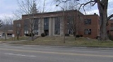
. It is the county seat
of Grainger County. It is part of the Morristown, Tennessee
Metropolitan Statistical Area
. As of the 2010 census, the town had a total population of 1,122, a decrease of 65 from 2000.
 Rutledge was established in 1798 and named for General George Rutledge, a prominent citizen in nearby Sullivan County. In 1801, Rutledge became the official county seat of Grainger County, a distinction that had been shared by several communities since the county's formation in 1796. Rutledge prospered in the early 19th century in part due to its situation along the Federal Road (now US-11W), which connected New Orleans
and Virginia. The road intersected the Old Kentucky Road (now US-25E) at Bean Station, just east of Rutledge.
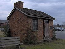
In the 1820s, future president Andrew Johnson
, who worked as a tailor in Greeneville
, briefly operated a tailor shop in Rutledge. In 1976, a replica of Johnson's tailor shop was erected on the Grainger County Courthouse lawn.
During the U.S. Civil War, guerilla warfare largely paralyzed Grainger County. In December 1863, Confederate
General James Longstreet
, who had earlier failed to wrest Knoxville from Union
forces, passed through Rutledge en route to winter quarters at Russellville
. On December 14, in what became known as the Battle of Bean's Station, Longstreet attacked a Union detachment that had been pursuing him. The Confederates failed to exploit the element of surprise, and the Union forces were able to hold out until reinforcements arrived. While Longstreet was victorious, Union forces were able to retreat to fortifications at Blaine, and Longstreet subsequently abandoned the assault and continued eastward to Russellville.
Cherokee Lake, created by the Tennessee Valley Authority
in 1941 with the completion of Cherokee Dam
, is located just south of Rutledge.
between Blaine
and Bean Station
. Richland Creek
traverses most of the valley en route to its confluence along the Cherokee Lake
impoundment of the Holston River
, approximately 20 miles (32.2 km) downstream from Rutledge. Cherokee Lake's Ray Creek embayment is located approximately 10 miles (16.1 km) east of Rutledge.
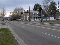
Rutledge is centered around the junction of U.S. Route 11W
, which connects the town to Kingsport
to the east and Knoxville
to the west, and Tennessee State Route 92, which connects the town to Jefferson County
and Interstate 40
to the south. U.S. Route 25
, which traverses Clinch Mountain, intersects US-11W approximately 10 miles (16.1 km) east of Rutledge.
According to the United States Census Bureau
, the town has a total area of 4.7 square miles (12.2 km²), all land.
 As of the census
of 2000, there were 1,187 people, 475 households, and 298 families residing in the town. The population density
was 253.1 people per square mile (97.7/km²). There were 530 housing units at an average density of 113.0 per square mile (43.6/km²). The racial makeup of the town was 96.88% White, 2.02% African American, 0.08% Native American, 0.08% Asian, 0.42% from other races, and 0.51% from two or more races. Hispanic or Latino of any race were 1.01% of the population.
There were 475 households out of which 27.2% had children under the age of 18 living with them, 46.9% were married couples
living together, 14.1% had a female householder with no husband present, and 37.1% were non-families. 34.7% of all households were made up of individuals and 18.1% had someone living alone who was 65 years of age or older. The average household size was 2.17 and the average family size was 2.76.
In the town the population was spread out with 19.0% under the age of 18, 5.7% from 18 to 24, 28.1% from 25 to 44, 21.7% from 45 to 64, and 25.4% who were 65 years of age or older. The median age was 43 years. For every 100 females there were 86.1 males. For every 100 females age 18 and over, there were 83.2 males.
The median income for a household in the town was $24,276, and the median income for a family was $33,571. Males had a median income of $26,151 versus $20,677 for females. The per capita income
for the town was $14,477. About 11.8% of families and 20.0% of the population were below the poverty line, including 20.8% of those under the age of 18 and 31.9% of those 65 and older.
Tennessee
Tennessee is a U.S. state located in the Southeastern United States. It has a population of 6,346,105, making it the nation's 17th-largest state by population, and covers , making it the 36th-largest by total land area...
, United States
United States
The United States of America is a federal constitutional republic comprising fifty states and a federal district...
. It is the county seat
County seat
A county seat is an administrative center, or seat of government, for a county or civil parish. The term is primarily used in the United States....
of Grainger County. It is part of the Morristown, Tennessee
Morristown, Tennessee
Morristown is a city in, and the county seat of, Hamblen County, Tennessee, United States. The population was 29,137 at the 2010 United States Census. It is the principal city of the Morristown, Tennessee Metropolitan Statistical Area, which encompasses all of Grainger, Hamblen and Jefferson counties...
Metropolitan Statistical Area
Morristown metropolitan area
The Morristown, Tennessee Metropolitan Statistical Area, as defined by the United States Census Bureau, is an area consisting of three counties - Grainger, Hamblen, and Jefferson - in eastern Tennessee, anchored by the city of Morristown. As of the 2000 census, the MSA had a population of 123,081...
. As of the 2010 census, the town had a total population of 1,122, a decrease of 65 from 2000.
History
New Orleans, Louisiana
New Orleans is a major United States port and the largest city and metropolitan area in the state of Louisiana. The New Orleans metropolitan area has a population of 1,235,650 as of 2009, the 46th largest in the USA. The New Orleans – Metairie – Bogalusa combined statistical area has a population...
and Virginia. The road intersected the Old Kentucky Road (now US-25E) at Bean Station, just east of Rutledge.
In the 1820s, future president Andrew Johnson
Andrew Johnson
Andrew Johnson was the 17th President of the United States . As Vice-President of the United States in 1865, he succeeded Abraham Lincoln following the latter's assassination. Johnson then presided over the initial and contentious Reconstruction era of the United States following the American...
, who worked as a tailor in Greeneville
Greeneville, Tennessee
Greeneville is a town in Greene County, Tennessee, United States. The population was 15,198 at the 2000 census. It is the county seat of Greene County. The town was named in honor of Revolutionary War hero Nathanael Greene. It is the only town with this spelling in the United States, although there...
, briefly operated a tailor shop in Rutledge. In 1976, a replica of Johnson's tailor shop was erected on the Grainger County Courthouse lawn.
During the U.S. Civil War, guerilla warfare largely paralyzed Grainger County. In December 1863, Confederate
Confederate States of America
The Confederate States of America was a government set up from 1861 to 1865 by 11 Southern slave states of the United States of America that had declared their secession from the U.S...
General James Longstreet
James Longstreet
James Longstreet was one of the foremost Confederate generals of the American Civil War and the principal subordinate to General Robert E. Lee, who called him his "Old War Horse." He served under Lee as a corps commander for many of the famous battles fought by the Army of Northern Virginia in the...
, who had earlier failed to wrest Knoxville from Union
Union (American Civil War)
During the American Civil War, the Union was a name used to refer to the federal government of the United States, which was supported by the twenty free states and five border slave states. It was opposed by 11 southern slave states that had declared a secession to join together to form the...
forces, passed through Rutledge en route to winter quarters at Russellville
Russellville, Tennessee
Russellville is an unincorporated community in Hamblen County, Tennessee, United States. Located along U.S. Route 11E, it lies approximately midway between Whitesburg and Morristown.-History:...
. On December 14, in what became known as the Battle of Bean's Station, Longstreet attacked a Union detachment that had been pursuing him. The Confederates failed to exploit the element of surprise, and the Union forces were able to hold out until reinforcements arrived. While Longstreet was victorious, Union forces were able to retreat to fortifications at Blaine, and Longstreet subsequently abandoned the assault and continued eastward to Russellville.
Cherokee Lake, created by the Tennessee Valley Authority
Tennessee Valley Authority
The Tennessee Valley Authority is a federally owned corporation in the United States created by congressional charter in May 1933 to provide navigation, flood control, electricity generation, fertilizer manufacturing, and economic development in the Tennessee Valley, a region particularly affected...
in 1941 with the completion of Cherokee Dam
Cherokee Dam
Cherokee Dam is a hydroelectric dam located on the Holston River in Grainger County and Jefferson County, Tennessee, in the southeastern United States. The dam is operated and maintained by the Tennessee Valley Authority, which built the dam in the early 1940s to help meet urgent demands for...
, is located just south of Rutledge.
Geography
Rutledge is located at 36°16′48"N 83°31′5"W (36.279991, -83.518008). The town is situated near the center of Richland Valley, a narrow valley that stretches for some 35 miles (56.3 km) along the southern base of Clinch MountainClinch Mountain
Clinch Mountain is a mountain ridge in the U.S. states of Tennessee and Virginia, lying in the ridge-and-valley section of the Appalachian Mountains...
between Blaine
Blaine, Tennessee
Blaine is a town in Grainger County, Tennessee, United States. It is part of the Morristown, Tennessee Metropolitan Statistical Area. The population was 1,856 at the 2010 census, an increase of 271 individuals since the 2000 census.-Geography:...
and Bean Station
Bean Station, Tennessee
Bean Station is a city in Grainger County, Tennessee, United States. It is part of the Morristown, Tennessee Metropolitan Statistical Area. The city was incorporated in November 1996...
. Richland Creek
Richland Creek
Richland Creek is a river in Texas.Richland Creek is also the name of the main creek flowing through Belleville, Illinois, and is a tributary to the Kaskaskia River.-References:**USGS Hydrologic Unit Map - State of Texas...
traverses most of the valley en route to its confluence along the Cherokee Lake
Cherokee Reservoir
Cherokee Reservoir, also known as Cherokee Lake, is a reservoir in Tennessee formed by the impoundment of the Holston River behind Cherokee Dam.The reservoir has a surface area of about , a flood-storage capacity of , and nearly of shoreline...
impoundment of the Holston River
Holston River
The Holston River is a major river system of southwestern Virginia and east Tennessee. The three major forks of the Holston rise in southwestern Virginia and have their confluence near Kingsport, Tennessee. The North Fork flows southwest from Sharon Springs in Bland County, Virginia...
, approximately 20 miles (32.2 km) downstream from Rutledge. Cherokee Lake's Ray Creek embayment is located approximately 10 miles (16.1 km) east of Rutledge.
Rutledge is centered around the junction of U.S. Route 11W
U.S. Route 11W
U.S. Route 11W is a divided highway of US 11 in the U.S. states of Tennessee and Virginia. The U.S. Highway, which is complemented by US 11E to the south and east, runs from US 11, US 11E, and US 70 in Knoxville, Tennessee north and east to US 11, US 11E, US 19, and US 421 in Bristol, Virginia...
, which connects the town to Kingsport
Kingsport, Tennessee
Kingsport is a city located mainly in Sullivan County with some western portions in Hawkins County in the US state of Tennessee. The majority of the city lies in Sullivan County...
to the east and Knoxville
Knoxville, Tennessee
Founded in 1786, Knoxville is the third-largest city in the U.S. state of Tennessee, U.S.A., behind Memphis and Nashville, and is the county seat of Knox County. It is the largest city in East Tennessee, and the second-largest city in the Appalachia region...
to the west, and Tennessee State Route 92, which connects the town to Jefferson County
Jefferson County, Tennessee
*...
and Interstate 40
Interstate 40
Interstate 40 is the third-longest major east–west Interstate Highway in the United States, after I-90 and I-80. Its western end is at Interstate 15 in Barstow, California; its eastern end is at a concurrency of U.S. Route 117 and North Carolina Highway 132 in Wilmington, North Carolina...
to the south. U.S. Route 25
U.S. Route 25
U.S. Route 25 is a north–south United States highway that runs for from Brunswick, Georgia to the Ohio state line in Covington, Kentucky.-Georgia:...
, which traverses Clinch Mountain, intersects US-11W approximately 10 miles (16.1 km) east of Rutledge.
According to the United States Census Bureau
United States Census Bureau
The United States Census Bureau is the government agency that is responsible for the United States Census. It also gathers other national demographic and economic data...
, the town has a total area of 4.7 square miles (12.2 km²), all land.
Demographics
Census
A census is the procedure of systematically acquiring and recording information about the members of a given population. It is a regularly occurring and official count of a particular population. The term is used mostly in connection with national population and housing censuses; other common...
of 2000, there were 1,187 people, 475 households, and 298 families residing in the town. The population density
Population density
Population density is a measurement of population per unit area or unit volume. It is frequently applied to living organisms, and particularly to humans...
was 253.1 people per square mile (97.7/km²). There were 530 housing units at an average density of 113.0 per square mile (43.6/km²). The racial makeup of the town was 96.88% White, 2.02% African American, 0.08% Native American, 0.08% Asian, 0.42% from other races, and 0.51% from two or more races. Hispanic or Latino of any race were 1.01% of the population.
There were 475 households out of which 27.2% had children under the age of 18 living with them, 46.9% were married couples
Marriage
Marriage is a social union or legal contract between people that creates kinship. It is an institution in which interpersonal relationships, usually intimate and sexual, are acknowledged in a variety of ways, depending on the culture or subculture in which it is found...
living together, 14.1% had a female householder with no husband present, and 37.1% were non-families. 34.7% of all households were made up of individuals and 18.1% had someone living alone who was 65 years of age or older. The average household size was 2.17 and the average family size was 2.76.
In the town the population was spread out with 19.0% under the age of 18, 5.7% from 18 to 24, 28.1% from 25 to 44, 21.7% from 45 to 64, and 25.4% who were 65 years of age or older. The median age was 43 years. For every 100 females there were 86.1 males. For every 100 females age 18 and over, there were 83.2 males.
The median income for a household in the town was $24,276, and the median income for a family was $33,571. Males had a median income of $26,151 versus $20,677 for females. The per capita income
Per capita income
Per capita income or income per person is a measure of mean income within an economic aggregate, such as a country or city. It is calculated by taking a measure of all sources of income in the aggregate and dividing it by the total population...
for the town was $14,477. About 11.8% of families and 20.0% of the population were below the poverty line, including 20.8% of those under the age of 18 and 31.9% of those 65 and older.
Notable native
- Robert Taylor JonesRobert Taylor JonesRobert Taylor Jones was the sixth Governor of the U.S. state of Arizona and served from 1939 to 1941. Born in Rutledge, Tennessee, he was a civil engineer and participated in the construction of the Panama Canal. He owned pharmacies in Phoenix and Tucson. He also owned the Jones Western Store in...
— ninth governor of ArizonaArizonaArizona ; is a state located in the southwestern region of the United States. It is also part of the western United States and the mountain west. The capital and largest city is Phoenix...
, was born in Rutledge.