
.gif)
Route 213 (Massachusetts)
Encyclopedia
Route 213 is a short 3½ mile state highway in Massachusetts
. It connects Interstate 93
with Interstate 495
in Methuen, Massachusetts
, just south of the New Hampshire
border. It is a four-lane, controlled access highway along its entire length. Route 213 is also known locally as The Loop, due to its semicircular routing between I-93 and I-495. Route 213 is famous for allowing a traveler to cross the entire breadth of the city of Methuen in 120 seconds. The highway is a northern bypass of Route 113, which serves the downtown area, and derives its own number from it.
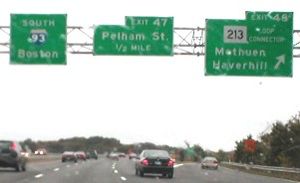
Signs for Route 213 on both I-93 and I-495 designate Route 213 as "LOOP CONNECTOR" (in all caps). The LOOP CONNECTOR signs were added when The Wilder Companies redeveloped the former Methuen Mall into a new shopping center known as The Loop.
According to MassDOT, Route 213 carries approximately 45,000 vehicles per day.
 Route 28 southbound provides access to the downtown area which Route 213 bypasses (it is a northern bypass of Route 113, which cuts west-to-east through the city). Route 28 northbound parallels I-93, crossing into Salem, New Hampshire
and becoming New Hampshire Route 28
after approximately one-half mile.
Route 213 contiunues eastward for about another mile before interchanging with Route 113 (Pleasant Street), with access between Route 113 and westbound Route 213 facilitated by nearby Howe Street. Another half mile or so to the east, Route 213 interchanges with Route 113 again, via a short connecting road to Exit 4. This exit provides nearby access to "The Loop." Route 213 continues a short distance to the east, crossing underneath Route 113 before ending at an interchange with I-495.
at US-3 at a point between exits 31 and 32. From there, it was to have run north, crossing the Merrimack River roughly at the site of the current Rourke Bridge. It would then continue north through a portion of the Lowell-Dracut State Forest before turning east through until crossing I-93 in Methuen and ending at I-495. However, environmental regulations, a growing opposition in both Lowell
and Dracut
, and a projected insufficient demand for the road caused the state to permanently kill the portion of the highway between US-3
and I-93
.
The expressway (which at this time was known as "Relocated Route 113") between I-93 and the current Exit 3 interchange was completed on September 11, 1962, when it was ceremonially named the Albert Slack Memorial Highway. The eastward extension to I-495 was completed in 1964, and Massachusetts Department of Public Works officially designated the road as Route 213. State officials unsuccessfully submitted for inclusion of Route 213 in the Interstate Highway System
in 1970, in an attempt to gain federal funding for the project. The submission was rejected by the Federal Highway Administration
.
Route 213 was officially designated as the Loop Connector in October 2000 by the Massachusetts legislature.
Massachusetts
The Commonwealth of Massachusetts is a state in the New England region of the northeastern United States of America. It is bordered by Rhode Island and Connecticut to the south, New York to the west, and Vermont and New Hampshire to the north; at its east lies the Atlantic Ocean. As of the 2010...
. It connects Interstate 93
Interstate 93
Interstate 93 is an Interstate Highway in the New England section of the United States. Its southern terminus is in Canton, Massachusetts, in the Boston metropolitan area, at Interstate 95; its northern terminus is near St. Johnsbury, Vermont, at Interstate 91...
with Interstate 495
Interstate 495 (Massachusetts)
Interstate 495 is the designation of an Interstate Highway half-beltway in Massachusetts. It was the longest auxiliary Interstate Highway of its kind—measuring 120.74 miles —until 1996, when the PA Route 9 section of the Pennsylvania Turnpike was redesignated as Interstate 476, making it about ...
in Methuen, Massachusetts
Methuen, Massachusetts
Methuen is a city in Essex County, Massachusetts, United States. The population was 43,789 at the 2000 census.-History:Methuen was first settled in 1642 and was officially incorporated in 1726; it is named for the British diplomat Sir Paul Methuen. Methuen was originally part of Haverhill,...
, just south of the New Hampshire
New Hampshire
New Hampshire is a state in the New England region of the northeastern United States of America. The state was named after the southern English county of Hampshire. It is bordered by Massachusetts to the south, Vermont to the west, Maine and the Atlantic Ocean to the east, and the Canadian...
border. It is a four-lane, controlled access highway along its entire length. Route 213 is also known locally as The Loop, due to its semicircular routing between I-93 and I-495. Route 213 is famous for allowing a traveler to cross the entire breadth of the city of Methuen in 120 seconds. The highway is a northern bypass of Route 113, which serves the downtown area, and derives its own number from it.
Signs for Route 213 on both I-93 and I-495 designate Route 213 as "LOOP CONNECTOR" (in all caps). The LOOP CONNECTOR signs were added when The Wilder Companies redeveloped the former Methuen Mall into a new shopping center known as The Loop.
According to MassDOT, Route 213 carries approximately 45,000 vehicles per day.
Route description
Route 213 begins in the west as an offshoot of I-93 at its northernmost exit in Massachusetts, Exit 48. It begins by traveling to the east for less than a half mile before meeting Route 28 (Broadway) at Exit 2.Salem, New Hampshire
Salem is a town in Rockingham County, New Hampshire, United States. The population was 28,776 at the 2010 census. Salem is a marketing and distributing center north of Boston, with a major amusement attraction, Canobie Lake Park, and a large shopping mall, the Mall at Rockingham Park.- History :The...
and becoming New Hampshire Route 28
New Hampshire Route 28
New Hampshire Route 28 is an north–south state highway in southeastern New Hampshire. It connects the town of Ossipee in east-central New Hampshire with Salem on the Massachusetts border....
after approximately one-half mile.
Route 213 contiunues eastward for about another mile before interchanging with Route 113 (Pleasant Street), with access between Route 113 and westbound Route 213 facilitated by nearby Howe Street. Another half mile or so to the east, Route 213 interchanges with Route 113 again, via a short connecting road to Exit 4. This exit provides nearby access to "The Loop." Route 213 continues a short distance to the east, crossing underneath Route 113 before ending at an interchange with I-495.
History
The road was initially planned to start in LowellLowell, Massachusetts
Lowell is a city in Middlesex County, Massachusetts, USA. According to the 2010 census, the city's population was 106,519. It is the fourth largest city in the state. Lowell and Cambridge are the county seats of Middlesex County...
at US-3 at a point between exits 31 and 32. From there, it was to have run north, crossing the Merrimack River roughly at the site of the current Rourke Bridge. It would then continue north through a portion of the Lowell-Dracut State Forest before turning east through until crossing I-93 in Methuen and ending at I-495. However, environmental regulations, a growing opposition in both Lowell
Lowell, Massachusetts
Lowell is a city in Middlesex County, Massachusetts, USA. According to the 2010 census, the city's population was 106,519. It is the fourth largest city in the state. Lowell and Cambridge are the county seats of Middlesex County...
and Dracut
Dracut, Massachusetts
Dracut is a town in Middlesex County, Massachusetts, United States. As of the 2010 census, the town population was 29,457. Dracut is primarily a suburban community, belonging to Greater Lowell and bordering southern New Hampshire...
, and a projected insufficient demand for the road caused the state to permanently kill the portion of the highway between US-3
U.S. Route 3
U.S. Route 3 is a north–south United States highway that runs from its southern terminus in Cambridge, Massachusetts through New Hampshire to its terminus near Third Connecticut Lake at the Canadian border, where the road continues north as Quebec Route 257.In New Hampshire parts of US 3 are...
and I-93
Interstate 93
Interstate 93 is an Interstate Highway in the New England section of the United States. Its southern terminus is in Canton, Massachusetts, in the Boston metropolitan area, at Interstate 95; its northern terminus is near St. Johnsbury, Vermont, at Interstate 91...
.
The expressway (which at this time was known as "Relocated Route 113") between I-93 and the current Exit 3 interchange was completed on September 11, 1962, when it was ceremonially named the Albert Slack Memorial Highway. The eastward extension to I-495 was completed in 1964, and Massachusetts Department of Public Works officially designated the road as Route 213. State officials unsuccessfully submitted for inclusion of Route 213 in the Interstate Highway System
Interstate Highway System
The Dwight D. Eisenhower National System of Interstate and Defense Highways, , is a network of limited-access roads including freeways, highways, and expressways forming part of the National Highway System of the United States of America...
in 1970, in an attempt to gain federal funding for the project. The submission was rejected by the Federal Highway Administration
Federal Highway Administration
The Federal Highway Administration is a division of the United States Department of Transportation that specializes in highway transportation. The agency's major activities are grouped into two "programs," the Federal-aid Highway Program and the Federal Lands Highway Program...
.
Route 213 was officially designated as the Loop Connector in October 2000 by the Massachusetts legislature.
Exit list
Exits are numbered from west to east.| County | Location | Exit | Mile | Intersecting roads | Notes |
|---|---|---|---|---|---|
| Essex Essex County, Massachusetts -National protected areas:* Parker River National Wildlife Refuge* Salem Maritime National Historic Site* Saugus Iron Works National Historic Site* Thacher Island National Wildlife Refuge-Demographics:... |
Methuen Methuen, Massachusetts Methuen is a city in Essex County, Massachusetts, United States. The population was 43,789 at the 2000 census.-History:Methuen was first settled in 1642 and was officially incorporated in 1726; it is named for the British diplomat Sir Paul Methuen. Methuen was originally part of Haverhill,... |
1A-B | 0.02 |  Interstate 93 Interstate 93Interstate 93 Interstate 93 is an Interstate Highway in the New England section of the United States. Its southern terminus is in Canton, Massachusetts, in the Boston metropolitan area, at Interstate 95; its northern terminus is near St. Johnsbury, Vermont, at Interstate 91... |
Western terminus of Route 213; I-93 Exit 48. Westbound exit/eastbound entrance. |
| 2 | 0.82 |  Route 28 Route 28Route 28 (Massachusetts) Route 28 is a nominally south–north route in the U.S. state of Massachusetts, running from the town of Orleans via Boston to the New Hampshire state line in Methuen. Following the route from its nominally southern end, Route 28 initially heads south to the town of Chatham then turns west to... |
To  NH Route 28 NH Route 28New Hampshire Route 28 New Hampshire Route 28 is an north–south state highway in southeastern New Hampshire. It connects the town of Ossipee in east-central New Hampshire with Salem on the Massachusetts border.... , via Route 28 North. |
||
| 3 | 2.15 |  Route 113 Route 113Route 113 (Massachusetts) Route 113 is a west–east Massachusetts state route that connects towns in the Merrimack River valley in northeastern Massachusetts. Its western terminus is at Route 119 in Pepperell, and its eastern end is at U.S. Route 1 and Route 1A in Newburyport.... (Pleasant Street) |
Access between Route 213 West and Route 113 via Howe Street. | ||
| 4 | 2.82 | Route 113 Route 113 (Massachusetts) Route 113 is a west–east Massachusetts state route that connects towns in the Merrimack River valley in northeastern Massachusetts. Its western terminus is at Route 119 in Pepperell, and its eastern end is at U.S. Route 1 and Route 1A in Newburyport.... (Pleasant Valley Street) |
To "The Loop" mall. | ||
| 5A-B | 3.56 |  I-495 I-495Interstate 495 (Massachusetts) Interstate 495 is the designation of an Interstate Highway half-beltway in Massachusetts. It was the longest auxiliary Interstate Highway of its kind—measuring 120.74 miles —until 1996, when the PA Route 9 section of the Pennsylvania Turnpike was redesignated as Interstate 476, making it about ... |
Eastern terminus of Route 213; I-495 Exit 47. Eastbound exit/westbound entrance. |
||