
River Dwyryd
Encyclopedia
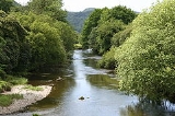
The Afon Dwyryd is a river
in Gwynedd
, North Wales
, which flows principally westwards draining to the sea into Tremadog Bay
south of Porthmadog
.
 The Dwyryd rises in the hill
s to the north of Ffestiniog
. At its most northern extent, water draining from Moelwyn Mawr
drains into the Tanygrisiau Reservoir, the outflow of which forms the source of the Afon Goedol. This is joined by the Afon Bowydd at grid reference
: . Below Rhyd y Sarn, the river is joined by the Afon Cynfal which flows from the east down a deep wooded gorge which includes the spectacular Rhaeadr Cynfal (Cynfal waterfall
) south of Ffestiniog
. The main river from here on flows through a wide valley formed by glaciation but with a broad flat base formed from re-worked glacial moraines and riverine gravel deposits. The valley, the Vale of Ffestiniog
, is worked for agriculture
but is subject to routine winter flooding.
Afon Tafarn-Helyg has its confluence
about one mile further downstream. This tributary
rises south of Gellilydan just north of the reservoir of Llyn Trawsfynydd
but does not receive any water from the reservoir
.
There are a number of small lake
s and reservoirs in the woodland
s north of Plas Tan y Bwlch
which also drain south into the river. These lakes include Llyn y Garnedd, Llyn Hafod y Llyn and the beautiful Llyn Mair
.
Llyn Trawsfynydd, a large impoundment close to the A470
, is the only inland water in the UK
that has been used as a source of cooling water for a nuclear power station. The outflow from Trawsfynydd reservoir, the Afon Prysor, flows down the steeply wooded valley of Ceunant Llennyrch before joining the main river at Maentwrog
. A large part of the flow from the reservoir is channelled through the hydro-electric power station
at Maentwrog and the flow from the station re-joins the Prysor before the confluence.
As the river moves into a long tidal estuary
, it flows under the railway line and under a toll road
and rail bridge known as Pont Briwet
. Due south of Portmeirion
the river is joined by the Afon y Glyn which drains the south west catchment from Llyn Tecwyn Uchaf and Llyn Tecwyn Isaf. The confluence is adjacent to Glastraeth (green beach) - a large extent of salt marsh
.
The estuary of the Dwyryd is long and sandy and includes the confluence of the Afon Glaslyn
close to the low water mark. The estuary is hauntingly beautiful, though some consider it spoiled by the crossing of National Grid pylons.
The whole of the river drains off igneous and ancient rocks of the Cambrian
and Ordovician
which are all base-poor. Much of the catchment has also been used for commercial forestry
during the last hundred years. As a consequence, many of the tributaries are highly acidic as a result of atmospheric acidification
. This has constrained the quality of the fishery and the bio-diversity in many tributaries. Some of these problems have been exacerbated by past industrial actions including metal mining, slate mining, animal skin processing and the use by the army
of a gunnery range with large amounts of implaced metal cartridge shells.
River
A river is a natural watercourse, usually freshwater, flowing towards an ocean, a lake, a sea, or another river. In a few cases, a river simply flows into the ground or dries up completely before reaching another body of water. Small rivers may also be called by several other names, including...
in Gwynedd
Gwynedd
Gwynedd is a county in north-west Wales, named after the old Kingdom of Gwynedd. Although the second biggest in terms of geographical area, it is also one of the most sparsely populated...
, North Wales
North Wales
North Wales is the northernmost unofficial region of Wales. It is bordered to the south by the counties of Ceredigion and Powys in Mid Wales and to the east by the counties of Shropshire in the West Midlands and Cheshire in North West England...
, which flows principally westwards draining to the sea into Tremadog Bay
Tremadog Bay
Tremadog Bay is a large inlet of Cardigan Bay, defined by the north Cambrian Coast and the Llŷn peninsula of north Wales.The River Glaslyn flows into the north of bay and St Tudwal's Islands lie at the western end of the bay...
south of Porthmadog
Porthmadog
Porthmadog , known locally as "Port", and historically rendered into English as Portmadoc, is a small coastal town and community in the Eifionydd area of Gwynedd, in Wales. Prior to the Local Government Act 1972 it was in the administrative county of Caernarfonshire. The town lies east of...
.
Hill
A hill is a landform that extends above the surrounding terrain. Hills often have a distinct summit, although in areas with scarp/dip topography a hill may refer to a particular section of flat terrain without a massive summit A hill is a landform that extends above the surrounding terrain. Hills...
s to the north of Ffestiniog
Ffestiniog
Ffestiniog is a community in Gwynedd in Wales, containing several villages, in particular the settlements of Llan Ffestiniog and Blaenau Ffestiniog. It has a population of 4,830....
. At its most northern extent, water draining from Moelwyn Mawr
Moelwyn Mawr
Moelwyn Mawr is a mountain in Snowdonia, North Wales and forms part of the Moelwynion. From its summit, which directly overlooks the Vale of Ffestiniog, it affords spectacular views in all directions....
drains into the Tanygrisiau Reservoir, the outflow of which forms the source of the Afon Goedol. This is joined by the Afon Bowydd at grid reference
British national grid reference system
The Ordnance Survey National Grid reference system is a system of geographic grid references used in Great Britain, different from using latitude and longitude....
: . Below Rhyd y Sarn, the river is joined by the Afon Cynfal which flows from the east down a deep wooded gorge which includes the spectacular Rhaeadr Cynfal (Cynfal waterfall
Waterfall
A waterfall is a place where flowing water rapidly drops in elevation as it flows over a steep region or a cliff.-Formation:Waterfalls are commonly formed when a river is young. At these times the channel is often narrow and deep. When the river courses over resistant bedrock, erosion happens...
) south of Ffestiniog
Ffestiniog
Ffestiniog is a community in Gwynedd in Wales, containing several villages, in particular the settlements of Llan Ffestiniog and Blaenau Ffestiniog. It has a population of 4,830....
. The main river from here on flows through a wide valley formed by glaciation but with a broad flat base formed from re-worked glacial moraines and riverine gravel deposits. The valley, the Vale of Ffestiniog
Vale of Ffestiniog
The Vale of Ffestiniog is a valley in the Snowdonia National Park in Gwynedd, North Wales. It stretches from Blaenau Ffestiniog in the east and runs in a westerly direction towards Tremadog Bay, terminating near Porthmadog...
, is worked for agriculture
Agriculture
Agriculture is the cultivation of animals, plants, fungi and other life forms for food, fiber, and other products used to sustain life. Agriculture was the key implement in the rise of sedentary human civilization, whereby farming of domesticated species created food surpluses that nurtured the...
but is subject to routine winter flooding.
Afon Tafarn-Helyg has its confluence
Confluence
Confluence, in geography, describes the meeting of two or more bodies of water.Confluence may also refer to:* Confluence , a property of term rewriting systems...
about one mile further downstream. This tributary
Tributary
A tributary or affluent is a stream or river that flows into a main stem river or a lake. A tributary does not flow directly into a sea or ocean...
rises south of Gellilydan just north of the reservoir of Llyn Trawsfynydd
Llyn Trawsfynydd
Llyn Trawsfynydd is a large man-made reservoir situated near the village of Trawsfynydd in Gwynedd, North Wales. With a total surface area of 4.8 km² the reservoir is slightly more extensive than Wales's largest natural lake, Llyn Tegid .Originally created in 1928 as the header reservoir for...
but does not receive any water from the reservoir
Reservoir
A reservoir , artificial lake or dam is used to store water.Reservoirs may be created in river valleys by the construction of a dam or may be built by excavation in the ground or by conventional construction techniques such as brickwork or cast concrete.The term reservoir may also be used to...
.
There are a number of small lake
Lake
A lake is a body of relatively still fresh or salt water of considerable size, localized in a basin, that is surrounded by land. Lakes are inland and not part of the ocean and therefore are distinct from lagoons, and are larger and deeper than ponds. Lakes can be contrasted with rivers or streams,...
s and reservoirs in the woodland
Woodland
Ecologically, a woodland is a low-density forest forming open habitats with plenty of sunlight and limited shade. Woodlands may support an understory of shrubs and herbaceous plants including grasses. Woodland may form a transition to shrubland under drier conditions or during early stages of...
s north of Plas Tan y Bwlch
Plas Tan y Bwlch
Plas Tan y Bwlch in Gwynedd, Wales is the Snowdonia National Park environmental studies centre, administered by the National Park Authority....
which also drain south into the river. These lakes include Llyn y Garnedd, Llyn Hafod y Llyn and the beautiful Llyn Mair
Llyn Mair
Llyn Mair is a artificial lake located at in North Wales. It lies in the area of Tan-y-Bwlch, a little above Plas Tan-y-Bwlch, and is in the catchment area of the River Dwyryd...
.
Llyn Trawsfynydd, a large impoundment close to the A470
A470 road
The A470 is a major long-distance connective spine road in Wales, running from Cardiff on the south coast to Llandudno on the north coast. It covers approximately 186 miles , over a zig-zagging route through the entirety of the country's mountainous central region, including the Brecon Beacons and...
, is the only inland water in the UK
United Kingdom
The United Kingdom of Great Britain and Northern IrelandIn the United Kingdom and Dependencies, other languages have been officially recognised as legitimate autochthonous languages under the European Charter for Regional or Minority Languages...
that has been used as a source of cooling water for a nuclear power station. The outflow from Trawsfynydd reservoir, the Afon Prysor, flows down the steeply wooded valley of Ceunant Llennyrch before joining the main river at Maentwrog
Maentwrog
Maentwrog is a village and community in the Welsh county of Gwynedd, lying in the Vale of Ffestiniog, within the Snowdonia National Park. The River Dwyryd runs alongside the village...
. A large part of the flow from the reservoir is channelled through the hydro-electric power station
Power station
A power station is an industrial facility for the generation of electric energy....
at Maentwrog and the flow from the station re-joins the Prysor before the confluence.
As the river moves into a long tidal estuary
Estuary
An estuary is a partly enclosed coastal body of water with one or more rivers or streams flowing into it, and with a free connection to the open sea....
, it flows under the railway line and under a toll road
Toll road
A toll road is a privately or publicly built road for which a driver pays a toll for use. Structures for which tolls are charged include toll bridges and toll tunnels. Non-toll roads are financed using other sources of revenue, most typically fuel tax or general tax funds...
and rail bridge known as Pont Briwet
Pont Briwet
Pont Briwet is a Grade II listed wooden bridge which crosses the River Dwyryd, located near to Penrhyndeudraeth, Gwynedd in North Wales.Built in 1860, the privately-owned toll road structure carries both the Cambrian Coast railway and a single-track road south to Harlech. Due to its age and weight...
. Due south of Portmeirion
Portmeirion
Portmeirion is a popular tourist village in Gwynedd, North Wales. It was designed and built by Sir Clough Williams-Ellis between 1925 and 1975 in the style of an Italian village and is now owned by a charitable trust....
the river is joined by the Afon y Glyn which drains the south west catchment from Llyn Tecwyn Uchaf and Llyn Tecwyn Isaf. The confluence is adjacent to Glastraeth (green beach) - a large extent of salt marsh
Salt marsh
A salt marsh is an environment in the upper coastal intertidal zone between land and salt water or brackish water, it is dominated by dense stands of halophytic plants such as herbs, grasses, or low shrubs. These plants are terrestrial in origin and are essential to the stability of the salt marsh...
.
The estuary of the Dwyryd is long and sandy and includes the confluence of the Afon Glaslyn
River Glaslyn
The Afon Glaslyn is a river in Gwynedd, north-west Wales. Whilst not of great significance in terms of its length , it is one of Gwynedd's primary rivers, and has greatly influenced the landscape in which it flows....
close to the low water mark. The estuary is hauntingly beautiful, though some consider it spoiled by the crossing of National Grid pylons.
The whole of the river drains off igneous and ancient rocks of the Cambrian
Cambrian
The Cambrian is the first geological period of the Paleozoic Era, lasting from Mya ; it is succeeded by the Ordovician. Its subdivisions, and indeed its base, are somewhat in flux. The period was established by Adam Sedgwick, who named it after Cambria, the Latin name for Wales, where Britain's...
and Ordovician
Ordovician
The Ordovician is a geologic period and system, the second of six of the Paleozoic Era, and covers the time between 488.3±1.7 to 443.7±1.5 million years ago . It follows the Cambrian Period and is followed by the Silurian Period...
which are all base-poor. Much of the catchment has also been used for commercial forestry
Forestry
Forestry is the interdisciplinary profession embracing the science, art, and craft of creating, managing, using, and conserving forests and associated resources in a sustainable manner to meet desired goals, needs, and values for human benefit. Forestry is practiced in plantations and natural stands...
during the last hundred years. As a consequence, many of the tributaries are highly acidic as a result of atmospheric acidification
Acid rain
Acid rain is a rain or any other form of precipitation that is unusually acidic, meaning that it possesses elevated levels of hydrogen ions . It can have harmful effects on plants, aquatic animals, and infrastructure. Acid rain is caused by emissions of carbon dioxide, sulfur dioxide and nitrogen...
. This has constrained the quality of the fishery and the bio-diversity in many tributaries. Some of these problems have been exacerbated by past industrial actions including metal mining, slate mining, animal skin processing and the use by the army
British Army
The British Army is the land warfare branch of Her Majesty's Armed Forces in the United Kingdom. It came into being with the unification of the Kingdom of England and Scotland into the Kingdom of Great Britain in 1707. The new British Army incorporated Regiments that had already existed in England...
of a gunnery range with large amounts of implaced metal cartridge shells.