
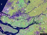
Rhine-Meuse-Scheldt delta
Encyclopedia
The Rhine–Meuse–Scheldt delta is a river delta
in the Netherlands and Belgium
formed by the confluence of the Rhine, the Meuse
and the Scheldt
river
s. The result is a multitude of island
s, branches and branch names that may at first sight look bewildering, especially as a waterway
that appears to be one continuous stream may change names as many as seven times, e.g. Rhine → Bijlands Kanaal
→ Pannerdens Kanaal
→ Nederrijn
→ Lek
→ Nieuwe Maas
→ Het Scheur
→ Nieuwe Waterweg
(→ North Sea
).Since the Rhine contributes most of the water, the shorter term Rhine Delta is commonly used. However, this name is also used for the river delta
where the Rhine flows into Lake Constance
, so it is clearer to call the larger one Rhine-Meuse delta, or even Rhine-Meuse-Scheldt Delta, as the Scheldt ends in the same delta.
The economic
importance of the Rhine–Meuse–Scheldt delta is enormous, since the three rivers are important navigable waterways. The delta is the entrance from the North Sea
to the vast German
and Central Europe
an hinterland
(and to a lesser extent France
). Major port
s in the delta are Rotterdam
, Antwerp
(Belgium), Flushing
, Amsterdam
(through the Amsterdam-Rhine Canal
), and Ghent
(through the Ghent-Terneuzen Canal
). The land areas in the Delta are protected from flooding by the Delta Works
.
 The shape of the Rhine delta is determined by two bifurcations: first, at Millingen aan de Rijn
, the Rhine splits into Waal
and Nederrijn
, and second near Arnhem
, the IJssel
branches off from the Nederrijn. This creates three main flows, two of which change names rather often. The largest and southern main branch begins as Waal and continues as Boven Merwede
("Upper Merwede"), Beneden Merwede
("Lower Merwede"), Noord River ("North River"), Nieuwe Maas
("New Meuse"), Het Scheur
("the Rip") and Nieuwe Waterweg
("New Waterway"). The middle flow begins as Nederrijn
, then changes into Lek, then joins the Noord, thereby forming Nieuwe Maas. The northern flow keeps the name IJssel until it flows into Lake IJsselmeer
. Three more flows carry significant amounts of water: the Nieuwe Merwede
("New Merwede"), which branches off from the southern branch where it changes from Boven to Beneden Merwede; the Oude Maas
("Old Meuse"), which branches off from the southern branch where it changes from Benede Merwede into Noord, and Dordtse Kil, which branches off from Oude Maas.
Before the St. Elizabeth's flood (1421)
the Meuse flowed just south of today's line Merwede-Oude Maas to the North Sea and formed an archipelago
-like estuary with Waal and Lek. This system of numerous bays, estuary-like extended rivers, many islands and constant changes of the coastline, is hard to imagine today. From 1421 to 1904, the Meuse and Waal merged further upstream at Gorinchem
to form Merwede
. For flood protection reasons, the Meuse was separated from the Waal through a lock and diverted into a new outlet called "Bergse Maas
", then Amer
and then flows into the former bay Hollands Diep
.
The northwestern part of the estuary (around Hook of Holland), is still called Maasmond ("Meuse Mouth"), ignoring the fact that it now carries only water from the Rhine. This might explain the confusing naming of the various branches.
The hydrography of the current delta is characterized by the delta's main arms, disconnected arms (Hollandse IJssel
, Linge
, Vecht
, etc.) and smaller rivers and streams. Many rivers have been closed ("dammed") and now serve as drainage channels for the numerous polders. The construction of Delta Works
changed the Delta in the second half of the 20th Century fundamentally. Currently Rhine water runs into the sea, or into former marine bays now separated from the sea, in five places, namely at the mouths of the Nieuwe Merwede, Nieuwe Waterway (Nieuwe Maas), Dordtse Kil, Spui
and IJssel.
The Rhine-Meuse Delta is a tidal delta, shaped not only by the sedimentation
of the rivers, but also by tidal currents. This meant that high tide formed a serious risk because strong tidal currents could tear huge areas of land into the sea. Before the construction of the Delta Works, tidal influence was palpable up to Nijmegen, and even today, after the regulatory action of the Delta Works, the tide
acts far inland. At the Waal, for example, the most landward tidal influence can be detected between Brakel
and Zaltbommel
.
River delta
A delta is a landform that is formed at the mouth of a river where that river flows into an ocean, sea, estuary, lake, reservoir, flat arid area, or another river. Deltas are formed from the deposition of the sediment carried by the river as the flow leaves the mouth of the river...
in the Netherlands and Belgium
Belgium
Belgium , officially the Kingdom of Belgium, is a federal state in Western Europe. It is a founding member of the European Union and hosts the EU's headquarters, and those of several other major international organisations such as NATO.Belgium is also a member of, or affiliated to, many...
formed by the confluence of the Rhine, the Meuse
Meuse River
The Maas or Meuse is a major European river, rising in France and flowing through Belgium and the Netherlands before draining into the North Sea...
and the Scheldt
Scheldt
The Scheldt is a 350 km long river in northern France, western Belgium and the southwestern part of the Netherlands...
river
River
A river is a natural watercourse, usually freshwater, flowing towards an ocean, a lake, a sea, or another river. In a few cases, a river simply flows into the ground or dries up completely before reaching another body of water. Small rivers may also be called by several other names, including...
s. The result is a multitude of island
Island
An island or isle is any piece of sub-continental land that is surrounded by water. Very small islands such as emergent land features on atolls can be called islets, cays or keys. An island in a river or lake may be called an eyot , or holm...
s, branches and branch names that may at first sight look bewildering, especially as a waterway
Waterway
A waterway is any navigable body of water. Waterways can include rivers, lakes, seas, oceans, and canals. In order for a waterway to be navigable, it must meet several criteria:...
that appears to be one continuous stream may change names as many as seven times, e.g. Rhine → Bijlands Kanaal
Bijlands Kanaal
thumb|right|Edited [[satellite]] [[image]] of the [[Rhine]]-[[Waal |Waal]] fork showing the Bijlands Kanaal .The Bijlands Kanaal is a canal in the Dutch province of Gelderland, near the Dutch-German border...
→ Pannerdens Kanaal
Pannerdens Kanaal
thumb|300px|right|Processed [[satellite]] [[image]] of the [[Rhine]]-[[Waal |Waal]] fork showing the location of the Pannerdens Kanaal .The Pannerdens Kanaal is a canal in the Netherlands that was dredged between 1701 and 1709 to cut off a large, shallow bend of river Rhine and so improve river...
→ Nederrijn
Nederrijn
thumb|left|300px|Course of the NederrijnNederrijn is the name of the Dutch part of the River Rhine from the confluence at the town of Angeren of the cut-off Rhine bend of Oude Rijn and the Pannerdens Kanaal...
→ Lek
Lek River
The Lek is a river in the western Netherlands of some 60 km in length. It is the continuation of the Nederrijn after the Kromme Rijn branches off at the town of Wijk bij Duurstede. The main westbound waterway is hereafter called the Lek River...
→ Nieuwe Maas
Nieuwe Maas
The Nieuwe Maas distributary of the Rhine River, and a former distributary of the Maas River, in the Dutch province of South Holland. It runs from the confluence of the rivers Noord and Lek, and flows west through Rotterdam. It ends west of the city where it meets the Oude Maas , near Vlaardingen,...
→ Het Scheur
Het Scheur
Het Scheur is a branch of the Rhine-Meuse delta in South Holland, Netherlands, that flows west from the confluence of the Oude Maas and Nieuwe Maas branches past the towns of Rozenburg and Maassluis...
→ Nieuwe Waterweg
Nieuwe Waterweg
The Nieuwe Waterweg is a ship canal in the Netherlands from het Scheur west of the town of Maassluis to the North Sea at Hook of Holland...
(→ North Sea
North Sea
In the southwest, beyond the Straits of Dover, the North Sea becomes the English Channel connecting to the Atlantic Ocean. In the east, it connects to the Baltic Sea via the Skagerrak and Kattegat, narrow straits that separate Denmark from Norway and Sweden respectively...
).Since the Rhine contributes most of the water, the shorter term Rhine Delta is commonly used. However, this name is also used for the river delta
River delta
A delta is a landform that is formed at the mouth of a river where that river flows into an ocean, sea, estuary, lake, reservoir, flat arid area, or another river. Deltas are formed from the deposition of the sediment carried by the river as the flow leaves the mouth of the river...
where the Rhine flows into Lake Constance
Lake Constance
Lake Constance is a lake on the Rhine at the northern foot of the Alps, and consists of three bodies of water: the Obersee , the Untersee , and a connecting stretch of the Rhine, called the Seerhein.The lake is situated in Germany, Switzerland and Austria near the Alps...
, so it is clearer to call the larger one Rhine-Meuse delta, or even Rhine-Meuse-Scheldt Delta, as the Scheldt ends in the same delta.
The economic
Economics
Economics is the social science that analyzes the production, distribution, and consumption of goods and services. The term economics comes from the Ancient Greek from + , hence "rules of the house"...
importance of the Rhine–Meuse–Scheldt delta is enormous, since the three rivers are important navigable waterways. The delta is the entrance from the North Sea
North Sea
In the southwest, beyond the Straits of Dover, the North Sea becomes the English Channel connecting to the Atlantic Ocean. In the east, it connects to the Baltic Sea via the Skagerrak and Kattegat, narrow straits that separate Denmark from Norway and Sweden respectively...
to the vast German
Germany
Germany , officially the Federal Republic of Germany , is a federal parliamentary republic in Europe. The country consists of 16 states while the capital and largest city is Berlin. Germany covers an area of 357,021 km2 and has a largely temperate seasonal climate...
and Central Europe
Central Europe
Central Europe or alternatively Middle Europe is a region of the European continent lying between the variously defined areas of Eastern and Western Europe...
an hinterland
Hinterland
The hinterland is the land or district behind a coast or the shoreline of a river. Specifically, by the doctrine of the hinterland, the word is applied to the inland region lying behind a port, claimed by the state that owns the coast. The area from which products are delivered to a port for...
(and to a lesser extent France
France
The French Republic , The French Republic , The French Republic , (commonly known as France , is a unitary semi-presidential republic in Western Europe with several overseas territories and islands located on other continents and in the Indian, Pacific, and Atlantic oceans. Metropolitan France...
). Major port
Port
A port is a location on a coast or shore containing one or more harbors where ships can dock and transfer people or cargo to or from land....
s in the delta are Rotterdam
Port of Rotterdam
The Port of Rotterdam is the largest port in Europe, located in the city of Rotterdam, Netherlands. From 1962 until 2004 it was the world's busiest port, now overtaken by first Shanghai and then Singapore...
, Antwerp
Port of Antwerp
The port of Antwerp, in Belgium, is a port in the heart of Europe accessible to capesize ships. Antwerp stands at the upper end of the tidal estuary of the Scheldt. The estuary is navigable by ships of more than 100,000 Gross Tons as far as 80 km inland. The inland location means that the port...
(Belgium), Flushing
Flushing, Netherlands
Vlissingen is a municipality and a city in the southwestern Netherlands on the former island of Walcheren. With its strategic location between the Scheldt river and the North Sea, Vlissingen has been an important harbour for centuries. It was granted city rights in 1315. In the 17th century...
, Amsterdam
Port of Amsterdam
The Port of Amsterdam is a seaport in Amsterdam, the Netherlands. The port is located on the bank of a bay named IJ and the North Sea Canal, with which it is connected to the North Sea. The port was first used in the 13th century and was one of the main ports of the Dutch East India Company in the...
(through the Amsterdam-Rhine Canal
Amsterdam-Rhine Canal
The Amsterdam–Rhine Canal or Amsterdam-Rijnkanaal is a canal in the Netherlands that was built to connect the port city of Amsterdam to the main shipping artery of the Rhine...
), and Ghent
Port of Ghent
The port of Ghent is the third biggest port in Belgium. The first port of Ghent was situated at the Scheldt river and later on at the Lys river. Since the Middle Ages Ghent has sought for a connection to the sea. In the 13th century via the Lieve canal to the Zwin near Damme, in the 16th century...
(through the Ghent-Terneuzen Canal
Ghent-Terneuzen Canal
The Ghent-Terneuzen Canal , also known as the "Sea Canal" is a canal linking Ghent in Belgium to the port of Terneuzen on the Westerschelde estuary in the Netherlands, thereby providing the former with better access to the sea.-History:The canal was constructed between 1823 and 1827 on the...
). The land areas in the Delta are protected from flooding by the Delta Works
Delta Works
The Delta Works is a series of construction projects in the southwest of the Netherlands to protect a large area of land around the Rhine-Meuse-Scheldt delta from the sea. The works consist of dams, sluices, locks, dikes, levees, and storm surge barriers...
.
Geography
Millingen aan de Rijn
Millingen aan de Rijn is a municipality and a town in the eastern Netherlands.-External links:*...
, the Rhine splits into Waal
Waal
River Waal is the main distributary branch of river Rhine flowing to the central Netherlands for about before joining the Meuse near Woudrichem to form the Boven Merwede. It is a major river which serves as the main waterway connecting the Rotterdam harbor and Germany. Nijmegen, Tiel, Zaltbommel...
and Nederrijn
Nederrijn
thumb|left|300px|Course of the NederrijnNederrijn is the name of the Dutch part of the River Rhine from the confluence at the town of Angeren of the cut-off Rhine bend of Oude Rijn and the Pannerdens Kanaal...
, and second near Arnhem
Arnhem
Arnhem is a city and municipality, situated in the eastern part of the Netherlands. It is the capital of the province of Gelderland and located near the river Nederrijn as well as near the St. Jansbeek, which was the source of the city's development. Arnhem has 146,095 residents as one of the...
, the IJssel
IJssel
River IJssel , sometimes called Gelderse IJssel to avoid confusion with its Hollandse IJssel namesake in the west of the Netherlands, is a branch of the Rhine in the Dutch provinces of Gelderland and Overijssel...
branches off from the Nederrijn. This creates three main flows, two of which change names rather often. The largest and southern main branch begins as Waal and continues as Boven Merwede
Boven Merwede
The Boven Merwede is a stretch of river in the Netherlands.The Afgedamde Maas river joins the Waal at Woudrichem to form the Boven Merwede, which at Hardinxveld-Giessendam splits into the Beneden Merwede river on the right and the Nieuwe Merwede river on the left. Its length is 8.8 km...
("Upper Merwede"), Beneden Merwede
Beneden Merwede
The Beneden Merwede is a stretch of river in the Netherlands, the continuation of the Boven Merwede after the branching-off of the Nieuwe Merwede ship canal. It flows from Hardinxveld-Giessendam to Dordrecht, where it splits into the Noord and Oude Maas rivers. Its length is 14.9 km...
("Lower Merwede"), Noord River ("North River"), Nieuwe Maas
Nieuwe Maas
The Nieuwe Maas distributary of the Rhine River, and a former distributary of the Maas River, in the Dutch province of South Holland. It runs from the confluence of the rivers Noord and Lek, and flows west through Rotterdam. It ends west of the city where it meets the Oude Maas , near Vlaardingen,...
("New Meuse"), Het Scheur
Het Scheur
Het Scheur is a branch of the Rhine-Meuse delta in South Holland, Netherlands, that flows west from the confluence of the Oude Maas and Nieuwe Maas branches past the towns of Rozenburg and Maassluis...
("the Rip") and Nieuwe Waterweg
Nieuwe Waterweg
The Nieuwe Waterweg is a ship canal in the Netherlands from het Scheur west of the town of Maassluis to the North Sea at Hook of Holland...
("New Waterway"). The middle flow begins as Nederrijn
Nederrijn
thumb|left|300px|Course of the NederrijnNederrijn is the name of the Dutch part of the River Rhine from the confluence at the town of Angeren of the cut-off Rhine bend of Oude Rijn and the Pannerdens Kanaal...
, then changes into Lek, then joins the Noord, thereby forming Nieuwe Maas. The northern flow keeps the name IJssel until it flows into Lake IJsselmeer
IJsselmeer
IJsselmeer is a shallow artificial lake of 1100 km² in the central Netherlands bordering the provinces of Flevoland, North Holland and Friesland, with an average depth of 5 to 6 m. The IJsselmeer is the largest lake in Western Europe....
. Three more flows carry significant amounts of water: the Nieuwe Merwede
Nieuwe Merwede
The Nieuwe Merwede is a canal that was constructed in 1870 to form a branch in the Rhine-Meuse delta. It was dug along the general trajectories of a number of minor Biesbosch creeks to reduce the risk of flooding by diverting the water away from the Beneden Merwede, and to facilitate navigation...
("New Merwede"), which branches off from the southern branch where it changes from Boven to Beneden Merwede; the Oude Maas
Oude Maas
The Oude Maas is a distributary of the Rhine River, and a former distributary of the Maas River, in the Dutch province of South Holland. It begins at the city of Dordrecht where the Beneden Merwede river splits into the Noord River and the Oude Maas...
("Old Meuse"), which branches off from the southern branch where it changes from Benede Merwede into Noord, and Dordtse Kil, which branches off from Oude Maas.
Before the St. Elizabeth's flood (1421)
St. Elizabeth's flood (1421)
The St. Elizabeth's flood of 1421 was a flooding of an area in what is now the Netherlands. It takes its name from the feast day of Saint Elisabeth of Hungary which was formerly November 19....
the Meuse flowed just south of today's line Merwede-Oude Maas to the North Sea and formed an archipelago
Archipelago
An archipelago , sometimes called an island group, is a chain or cluster of islands. The word archipelago is derived from the Greek ἄρχι- – arkhi- and πέλαγος – pélagos through the Italian arcipelago...
-like estuary with Waal and Lek. This system of numerous bays, estuary-like extended rivers, many islands and constant changes of the coastline, is hard to imagine today. From 1421 to 1904, the Meuse and Waal merged further upstream at Gorinchem
Gorinchem
Gorinchem , also called Gorkum , is a city and municipality in the western Netherlands, in the province of South Holland. The municipality covers an area of 21.99 km² of which 3.03 km² is water...
to form Merwede
Merwede
The Merwede is the name of several interconnected stretches of river in The Netherlands, all part of the Rhine-Meuse-Scheldt delta. The Meuse river joins the Waal at Woudrichem to form the Boven Merwede...
. For flood protection reasons, the Meuse was separated from the Waal through a lock and diverted into a new outlet called "Bergse Maas
Bergse Maas
The Bergse Maas is a canal that was constructed in 1904 to be a branch of the Maas River in the Dutch province of North Brabant. The Maas splits near Heusden into the Afgedamde Maas and the Bergse Maas...
", then Amer
Amer
thumb|right|[[Satellite]] [[image]] of the [[Rhine]]-[[Meuse river|Meuse]] [[river delta|delta]], showing the Amer The Amer is a river in the Dutch province of Noord-Brabant...
and then flows into the former bay Hollands Diep
Hollands Diep
Hollands Diep is a wide river in the Netherlands and an estuary of the Rhine and Meuse river. Through the Scheldt-Rhine Canal it connects to the Scheldt river and Antwerp....
.
The northwestern part of the estuary (around Hook of Holland), is still called Maasmond ("Meuse Mouth"), ignoring the fact that it now carries only water from the Rhine. This might explain the confusing naming of the various branches.
The hydrography of the current delta is characterized by the delta's main arms, disconnected arms (Hollandse IJssel
Hollandse IJssel
The Hollandse IJssel is a branch of the Rhine delta that flows westward from Nieuwegein on river Lek through IJsselstein, Gouda and Capelle aan den IJssel to Krimpen aan den IJssel, where it ends in the Nieuwe Maas. Another branch called Enge IJssel flows southwest from Nieuwegein...
, Linge
Linge
Linge is a river in the Betuwe that is over 100 km long, which makes it one of the longest rivers that flow entirely within the Netherlands.It starts near the village Doornenburg near the German border. A legend tells us that if there will be no more pigs grazing at the castle of Doornenburg, the...
, Vecht
Vecht (Utrecht)
thumb|right|[[Satellite]] [[image]] of the surroundings of [[Utrecht |Utrecht]] showing river Vecht and the [[Amsterdam-Rhine Canal]] .220px|thumb|right|Location of river Vecht ....
, etc.) and smaller rivers and streams. Many rivers have been closed ("dammed") and now serve as drainage channels for the numerous polders. The construction of Delta Works
Delta Works
The Delta Works is a series of construction projects in the southwest of the Netherlands to protect a large area of land around the Rhine-Meuse-Scheldt delta from the sea. The works consist of dams, sluices, locks, dikes, levees, and storm surge barriers...
changed the Delta in the second half of the 20th Century fundamentally. Currently Rhine water runs into the sea, or into former marine bays now separated from the sea, in five places, namely at the mouths of the Nieuwe Merwede, Nieuwe Waterway (Nieuwe Maas), Dordtse Kil, Spui
Spui
Spui is a Dutch term meaning a specific type of small sluice used for refreshing the network of waterways in a village or town. It may refer to the following things:*Spui, a river in the Netherlands...
and IJssel.
The Rhine-Meuse Delta is a tidal delta, shaped not only by the sedimentation
Sedimentation
Sedimentation is the tendency for particles in suspension to settle out of the fluid in which they are entrained, and come to rest against a barrier. This is due to their motion through the fluid in response to the forces acting on them: these forces can be due to gravity, centrifugal acceleration...
of the rivers, but also by tidal currents. This meant that high tide formed a serious risk because strong tidal currents could tear huge areas of land into the sea. Before the construction of the Delta Works, tidal influence was palpable up to Nijmegen, and even today, after the regulatory action of the Delta Works, the tide
Tide
Tides are the rise and fall of sea levels caused by the combined effects of the gravitational forces exerted by the moon and the sun and the rotation of the Earth....
acts far inland. At the Waal, for example, the most landward tidal influence can be detected between Brakel
Brakel
Brakel is a municipality in the Belgian province of East Flanders in the Denderstreek and the Flemish Ardennes. The name is derived from a Carolingian villa Braglo first mentioned in 866 and located in the center of Opbrakel. Since 1970, the municipality has comprised the villages of Nederbrakel,...
and Zaltbommel
Zaltbommel
Zaltbommel is a municipality and a city in the Netherlands. The town of Zaltbommel was first mentioned as "Bomela" in the year 850. Zaltbommel first received city status in 1231, which status was renewed in 1316....
.