

Reddish Vale
Encyclopedia
Reddish Vale is a loosely defined area in the Tame Valley
close to Reddish
in the Metropolitan Borough of Stockport
, Greater Manchester
, England
. The generally-accepted centre of the vale (as indicated on maps) is around the bottom of Reddish Vale Road. Reddish Vale Country Park is a country park
managed by Stockport Metropolitan Borough Council. It covers 161 hectares in all and comprises some of the traditional Reddish Vale area, Reddish Vale Farm and the grazing land and Woodhall Fields, about half a mile to the south.
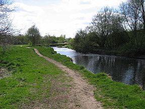
 Reddish Vale is mainly green space, comprising woodland, flat riverside meadows, sloping fields used to graze horses and a golf course. At the end of Reddish Vale Road near is a small car park and a visitor centre housed in portable cabins. A number of footpaths lead in all directions, with the more popular ones following the line of the river, both up and downstream.
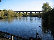
Highly visible from the visitor centre is the sixteen-arch brick viaduct built in 1875 to carry the Hope Valley Line
over the Tame Valley. There is a legend that during construction a local witch cursed the viaduct and anyone who counted the number of arches. A railway line once led to Stockport from Reddish Junction at the Brinnington
(east) side of the viaduct. This line has been turned into a public bridleway joining the two parts of the country park and forms a section of the Trans Pennine Trail
. The Stockport to Stalybridge Line
forms part of the western boundary of the vale. A spur once ran to the colliery at Denton
. Its position is still visible in places marked by a hedgerow that runs alongside Ross Lave Lane. Where the line had to span Denton Brook an embankment was built using slag and other waste from the mine. This slag was ignited by the hot summers of 1975 and 1976. It continued to smoulder and smoke for a number years until the site was bulldozed and cleared in 1981. Train drivers called the place 'smokey ridge', along the bottom of Denton Brook you can still see the bricks used for the tunnel. Some locals refer to Ross Lave Lane as 'piggy's alley' as there was once a pig farm on the Denton side of the viaduct on the embankment above where Denton Brook joins the River Tame. There was a plan at the end of the 18th century for the Beat Bank Branch Canal
to run across the vale, and some sections were dug, but it was abandoned before completion.
Nearby are two mill ponds left over from industrial activity in the vale. The ponds were fed from the river above a weir (destroyed in floods in the 1960s, all that remains is the sluice gate) on the upstream side of the viaduct, and provided both power and processing water to Reddish Vale Print Works, a calico
printing works dating from before 1800. The works had ceased printing by 1975, and have now been demolished and the land turned into a butterfly park. The ponds are now used for angling, and attract herons and a variety of ducks. Most of the race has been filled in, but a short length carries Denton Brook down to the river. Denton Brook (and a small tributary) marks the traditional boundary between Reddish and Denton. The manorial corn mill (one of several to be known as Reddish Mill) was sited over the brook and was demolished in about 1860 when the ponds were extended.
 Woodhall Fields form the southern or lower (with reference to the river) part of the park. There is a small car park accessible from Tiviot Way near . The weir here was used to feed the Portwood Cut, dug in 1796, which ran to the Portwood
area of Stockport and powered a number of mills around the start of the 19th century. Part of the fields were once a landfill site for fly ash
; this has proved to be a good growing medium for orchids. As of October 2006, this part of the park has a poor reputation.
Whilst not really in the vale, at the northern end the late 16th century Arden Hall or 'Cromwell's Castle' (where Oliver Cromwell
allegedly spent the night) and the 17th century Hyde Hall
overlook it and form part of the overall landscape. Both are in private hands and not open to the public.
Just above the visitor centre, on Reddish Vale Road, is Reddish Vale Farm, with riding stables and a children's farm. The buildings and associated grazing were Stockton's Dairy Farm until 1996.
The Trans Pennine Trail
and the Tame Valley Walk pass through the park.
There were nine houses situated between the viaduct and the mill ponds, built to house the workers constructing the viaduct. They were later demolished for expansion of the reservoirs. On the opposite side of the river to where Strines
Weir once was there were two houses known as Strines Cottages which were farm dwellings. A recent archaeological dig found the foundations of these structures. There was a flour mill situated above Denton Brook not far from Mill Lane. In later years it was used as a school and was known as 'the ark' because of the flowing water visible through the gaps in the floorboards. It appears that there has never been a church in the vale.
In 1988, the government of the day asked the Greater Manchester Residuary Body
to sell off its holdings in the area; 3,000 people, worried that it would be sold to developers, gathered in the vale to protest. The land was acquired by Stockport Council in 1995. They arrived as three contingents from Brinnington
, North Reddish
and South Reddish
.
In 1990, a proposal to create an artificial ski slope at Woodhall Fields was opposed by 7,000 signatories to a petition. The opposition was led by the Tame Valley Defence Group supported by MP Andrew Bennett
and the Reddish Reporter. The Defence Group had made trips to the various ski slopes and supplied local people with reports on Sheffield
Ski Slope. This proposal echoed an earlier proposal for a snow dome which was opposed by South Reddish Action Group, who were later to merge with the Tame Valley Defence Group to protect the vale.
In 1992, the golf club hoped to use part of the vale as landfill; the plans did not come to fruition. This again was opposed by the Tame Valley Defence Group who were strongly supported in this by the Director of Public Health in Stockport.
River Tame, Greater Manchester
The River Tame flows through Greater Manchester, England.-Source:The Tame rises on Denshaw Moor in Greater Manchester, close to the border with West Yorkshire but within the historic West Riding of Yorkshire.-Course:...
close to Reddish
Reddish
Reddish is an area of the Metropolitan Borough of Stockport, in Greater Manchester, England. It is north of Stockport and southeast of Manchester...
in the Metropolitan Borough of Stockport
Metropolitan Borough of Stockport
The Metropolitan Borough of Stockport is a metropolitan borough of Greater Manchester, in north west England, centred around the town of Stockport. It has a population of about 280,600 and includes the outyling areas of Cheadle and Cheadle Hulme, Marple, Bredbury, Reddish and Romiley...
, Greater Manchester
Greater Manchester
Greater Manchester is a metropolitan county in North West England, with a population of 2.6 million. It encompasses one of the largest metropolitan areas in the United Kingdom and comprises ten metropolitan boroughs: Bolton, Bury, Oldham, Rochdale, Stockport, Tameside, Trafford, Wigan, and the...
, England
England
England is a country that is part of the United Kingdom. It shares land borders with Scotland to the north and Wales to the west; the Irish Sea is to the north west, the Celtic Sea to the south west, with the North Sea to the east and the English Channel to the south separating it from continental...
. The generally-accepted centre of the vale (as indicated on maps) is around the bottom of Reddish Vale Road. Reddish Vale Country Park is a country park
Country park
A country park is an area designated for people to visit and enjoy recreation in a countryside environment.-History:In the United Kingdom the term 'Country Park' has a special meaning. There are over 400 Country Parks in England alone . Most Country Parks were designated in the 1970s, under the...
managed by Stockport Metropolitan Borough Council. It covers 161 hectares in all and comprises some of the traditional Reddish Vale area, Reddish Vale Farm and the grazing land and Woodhall Fields, about half a mile to the south.
Description
Highly visible from the visitor centre is the sixteen-arch brick viaduct built in 1875 to carry the Hope Valley Line
Hope Valley Line
The Hope Valley Line is a railway line in England linking Sheffield with Manchester. It was completed in 1894.From Sheffield, trains head down the Midland Main Line to Dore, where the Hope Valley Line branches off to run through the Totley Tunnel .It emerges in the stunning scenery of the Hope...
over the Tame Valley. There is a legend that during construction a local witch cursed the viaduct and anyone who counted the number of arches. A railway line once led to Stockport from Reddish Junction at the Brinnington
Brinnington
Brinnington is a north-eastern suburb of Stockport, Greater Manchester. It is known locally as "Brinny".It is situated on a bluff above a bend in the Tame Valley and is an area of vast regeneration, including the demolition of the Top Shops in 2007, which were replaced by new shops, 53 shared...
(east) side of the viaduct. This line has been turned into a public bridleway joining the two parts of the country park and forms a section of the Trans Pennine Trail
Trans Pennine Trail
The Trans Pennine Trail is a long distance path running from coast to coast across northern England entirely on surfaced paths and using only gentle gradients ....
. The Stockport to Stalybridge Line
Stockport to Stalybridge Line
The Stockport to Stalybridge Line is a short railway line in Greater Manchester, running from Stockport north east to Stalybridge. Although it once received a frequent service, for the past few years it has been served by a single train run by Northern Rail, once a week in one direction.This...
forms part of the western boundary of the vale. A spur once ran to the colliery at Denton
Denton, Greater Manchester
Denton is a town within the Metropolitan Borough of Tameside, in Greater Manchester, England. It is five miles to the east of Manchester city centre, and has a population of 26,866....
. Its position is still visible in places marked by a hedgerow that runs alongside Ross Lave Lane. Where the line had to span Denton Brook an embankment was built using slag and other waste from the mine. This slag was ignited by the hot summers of 1975 and 1976. It continued to smoulder and smoke for a number years until the site was bulldozed and cleared in 1981. Train drivers called the place 'smokey ridge', along the bottom of Denton Brook you can still see the bricks used for the tunnel. Some locals refer to Ross Lave Lane as 'piggy's alley' as there was once a pig farm on the Denton side of the viaduct on the embankment above where Denton Brook joins the River Tame. There was a plan at the end of the 18th century for the Beat Bank Branch Canal
Beat Bank Branch Canal
The Beat Bank Branch Canal was an abortive canal near Manchester, England. It was to leave the Stockport Branch Canal in South Reddish and it was to be lock free but with a short tunnel. It was to follow the contour above the right bank of the River Tame, firstly in a northerly direction and then...
to run across the vale, and some sections were dug, but it was abandoned before completion.
Nearby are two mill ponds left over from industrial activity in the vale. The ponds were fed from the river above a weir (destroyed in floods in the 1960s, all that remains is the sluice gate) on the upstream side of the viaduct, and provided both power and processing water to Reddish Vale Print Works, a calico
Calico (fabric)
Calico is a plain-woven textile made from unbleached, and often not fully processed, cotton. It may contain unseparated husk parts, for example. The fabric is less coarse and thick than canvas or denim, but owing to its unfinished and undyed appearance, it is still very cheap. Originally from the...
printing works dating from before 1800. The works had ceased printing by 1975, and have now been demolished and the land turned into a butterfly park. The ponds are now used for angling, and attract herons and a variety of ducks. Most of the race has been filled in, but a short length carries Denton Brook down to the river. Denton Brook (and a small tributary) marks the traditional boundary between Reddish and Denton. The manorial corn mill (one of several to be known as Reddish Mill) was sited over the brook and was demolished in about 1860 when the ponds were extended.
Portwood
Portwood is an area in Stockport, England, lying just outside the town centre, and based around Great Portwood Street. It is a mixed area, with the part closest to the town centre mainly given over to shops and the further part residential...
area of Stockport and powered a number of mills around the start of the 19th century. Part of the fields were once a landfill site for fly ash
Fly ash
Fly ash is one of the residues generated in combustion, and comprises the fine particles that rise with the flue gases. Ash which does not rise is termed bottom ash. In an industrial context, fly ash usually refers to ash produced during combustion of coal...
; this has proved to be a good growing medium for orchids. As of October 2006, this part of the park has a poor reputation.
Whilst not really in the vale, at the northern end the late 16th century Arden Hall or 'Cromwell's Castle' (where Oliver Cromwell
Oliver Cromwell
Oliver Cromwell was an English military and political leader who overthrew the English monarchy and temporarily turned England into a republican Commonwealth, and served as Lord Protector of England, Scotland, and Ireland....
allegedly spent the night) and the 17th century Hyde Hall
Hyde Hall, Denton
Hyde Hall in Denton is Grade II* Listed Building and was home to a branch of the Hyde family of Denton and Hyde. The building was built partially in brick and stone and partially from timber. Below the Hyde coat of arms is an inscription dating the hall to at least 1625, and was probably...
overlook it and form part of the overall landscape. Both are in private hands and not open to the public.
Other activities
Reddish Vale Golf Club takes up a substantial area on both sides of the river, but does not form part of the country park. The club house was once a substantial private house in its own grounds.Just above the visitor centre, on Reddish Vale Road, is Reddish Vale Farm, with riding stables and a children's farm. The buildings and associated grazing were Stockton's Dairy Farm until 1996.
The Trans Pennine Trail
Trans Pennine Trail
The Trans Pennine Trail is a long distance path running from coast to coast across northern England entirely on surfaced paths and using only gentle gradients ....
and the Tame Valley Walk pass through the park.
Housing
There is now very little housing in the vale. There are 12 terraced houses opposite the farm on the road leading down to the vale. At the bottom of the road opposite the visitors centre is a large dwelling known as Tame House. Tame House was once the offices for the Calico print works. At the back of Tame House is a dirt track called Riverview; there are kennels for racing greyhounds halfway down the track. This was once the canteen for the workers at the print works. Adjacent to the canteen was a large Victorian house but this was demolished in the 1960s. Further along Riverview, where the track meets the river, once stood two rows of terraced houses identical to the ones opposite the farm. These were also demolished in the 1960s after being declared 'slum dwellings'. The same fate may have befallen the terraces opposite the farm if not for the intervention of two twin brothers, John and Christopher Byrne, who removed the Compulsory Purchase Orders put on them, and organised the installation of a sanitation system.There were nine houses situated between the viaduct and the mill ponds, built to house the workers constructing the viaduct. They were later demolished for expansion of the reservoirs. On the opposite side of the river to where Strines
Strines
Strines is a village in Greater Manchester, located in the valley of the River Goyt midway between Marple and New Mills and about six miles southeast of Stockport. The village falls mainly within Marple parish and Stockport metropolitan borough, though a small part falls within the boundaries of...
Weir once was there were two houses known as Strines Cottages which were farm dwellings. A recent archaeological dig found the foundations of these structures. There was a flour mill situated above Denton Brook not far from Mill Lane. In later years it was used as a school and was known as 'the ark' because of the flowing water visible through the gaps in the floorboards. It appears that there has never been a church in the vale.
Recent threats
Recent proposals to change the nature of the vale have been met with robust opposition.In 1988, the government of the day asked the Greater Manchester Residuary Body
Greater Manchester County Council
The Greater Manchester County Council — also known as the Greater Manchester Council — was the top-tier local government administrative body for Greater Manchester from 1974 to 1986...
to sell off its holdings in the area; 3,000 people, worried that it would be sold to developers, gathered in the vale to protest. The land was acquired by Stockport Council in 1995. They arrived as three contingents from Brinnington
Brinnington
Brinnington is a north-eastern suburb of Stockport, Greater Manchester. It is known locally as "Brinny".It is situated on a bluff above a bend in the Tame Valley and is an area of vast regeneration, including the demolition of the Top Shops in 2007, which were replaced by new shops, 53 shared...
, North Reddish
North Reddish
North Reddish is the northern part of Reddish, in Stockport, Greater Manchester.North Reddish or Reddish North can refer to:* A loosely defined geographical area covering the northern part of Reddish;...
and South Reddish
South Reddish
South Reddish is the southern part of Reddish, in Stockport, Greater Manchester.South Reddish or Reddish South can refer to:* A loosely defined geographical area covering the southern part of Reddish;...
.
In 1990, a proposal to create an artificial ski slope at Woodhall Fields was opposed by 7,000 signatories to a petition. The opposition was led by the Tame Valley Defence Group supported by MP Andrew Bennett
Andrew Bennett
Andrew Francis Bennett is a British Labour Party politician, who was a member of Parliament from 1974 to 2005.-Early life:...
and the Reddish Reporter. The Defence Group had made trips to the various ski slopes and supplied local people with reports on Sheffield
Sheffield
Sheffield is a city and metropolitan borough of South Yorkshire, England. Its name derives from the River Sheaf, which runs through the city. Historically a part of the West Riding of Yorkshire, and with some of its southern suburbs annexed from Derbyshire, the city has grown from its largely...
Ski Slope. This proposal echoed an earlier proposal for a snow dome which was opposed by South Reddish Action Group, who were later to merge with the Tame Valley Defence Group to protect the vale.
In 1992, the golf club hoped to use part of the vale as landfill; the plans did not come to fruition. This again was opposed by the Tame Valley Defence Group who were strongly supported in this by the Director of Public Health in Stockport.
External links
- Reddish Vale's Community Website Information About Reddish Vale's Flora and Fauna, History and News.
- Reddish Vale Country Park website
- Map showing the boundaries of the country park