
Randolph, New Hampshire
Encyclopedia
Randolph is a heavily forested town
in Coos County
, New Hampshire
, U.S.
, extending from the northern slopes of the White Mountains
of the Presidential Range
(to the south) to Berlin
(to the north), with U.S. Route 2 cutting through the middle. The northern and southern parts of Randolph are within the White Mountain National Forest
and the Ice Gulch Town Forest, while the central part is the settled portion of town. As of the 2010 census, the town had a total population of 310.
Randolph is part of the Berlin, NH–VT
Micropolitan Statistical Area
.
, a Virginia
congressman and senator, and a descendant of Pocahontas
.
 According to the United States Census Bureau
, the town has a total area of 47.2 square miles (122.2 km²), of which 47.1 sq mi (122 km²) is land and 0.04 sq mi (0.1035995244 km²) is water, comprising 0.08% of the town.
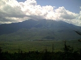
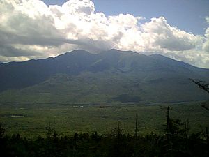
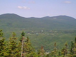
Randolph's geography is mountainous. The south side of the town includes the northern slopes of the Presidentials. The north side of the town includes four main mountains: Mount Crescent
, Black Crescent Mountain
, Mount Randolph and Pond Hill. Dividing the northerly slopes from the southerly slopes is US Route 2. There are no trails maintained to the top of Black Crescent Mountain or Pond Hill. The highest point in Randolph is on the town's southern border, atop a 3950 feet (1,204 m) knob on Howker Ridge, a spur of Mount Madison
.
The settled part of Randolph is divided into two main areas: Randolph "valley", where town hall is, and Randolph Hill, which has several roads all connected to a main road called Randolph Hill Road. Randolph Hill has the site of the Mt. Crescent House (hotel), which opened in 1883 as the "Randolph Hill House" and was torn down in 1971. Randolph also had "Ravine House" on Durand Road, straight north of the Appalachia trailhead. Other sections of town include the area west of Durand Road, which includes Valley Road and a number of houses along Route 2, towards Jefferson
. The main Randolph train station was at Appalachia. Other, secondary stations included "Randolph East" on the Dolly Copp (or "Pinkham B") Road, and Bowman, at the height of land to the west. The only general store in Randolph is the Lowe's Store, on U.S. Route 2. There are two motels and one bed and breakfast within the town.
Temperatures in the summer can reach nearly 100 °F, though that is exceedingly rare, with summer days seldom getting above the 80's and summer nights frequently being in the 50's or even the 40's. Temperatures in the winter can be below -40°F.
of 2000, there were 339 people, 146 households, and 104 families residing in the town. The population density
was 7.2 people per square mile (2.8/km²). There were 298 housing units at an average density of 6.3 per square mile (2.4/km²). The racial makeup of the town was 96.46% White, 0.88% African American, 0.29% Native American, 0.29% Asian, 0.29% from other races
, and 1.77% from two or more races. Hispanic or Latino of any race were 0.59% of the population.
There were 146 households out of which 26.0% had children under the age of 18 living with them, 69.2% were married couples
living together, 1.4% had a female householder with no husband present, and 28.1% were non-families. 24.0% of all households were made up of individuals and 8.9% had someone living alone who was 65 years of age or older. The average household size was 2.31 and the average family size was 2.74.
In the town the population was spread out with 19.2% under the age of 18, 5.0% from 18 to 24, 25.1% from 25 to 44, 32.2% from 45 to 64, and 18.6% who were 65 years of age or older. The median age was 46 years. For every 100 females there were 104.2 males. For every 100 females age 18 and over, there were 106.0 males.
The median income for a household in the town was $50,139, and the median income for a family was $52,083. Males had a median income of $40,625 versus $35,208 for females. The per capita income
for the town was $25,092. About 2.0% of families and 1.8% of the population were below the poverty line, including none of those under the age of eighteen or sixty-five or over.
Many houses in Randolph are summer/vacation homes. Historically, vacationers tended to visit the hotels, reachable by horse-drawn carriage from the Randolph train station; but as the automobile became more popular, the hotels declined and private vacation homes became more prevalent. Vacationing in the far north was particularly advantageous before the air conditioner became common, as Randolph summers are rarely very hot—and never hot at all in the higher mountain areas. The town has a strong group of people who spent entire summers there during the Depression
and World War II
era. These people all know each other well, and many have retired there. As they age and die off, though, the younger generation of vacationers, who can no longer afford six-week vacations, are less tightly knit.
 Randolph is located in a mountainous region that attracts hikers. Because of this, the RMC (Randolph Mountain Club) was formed (see subsection below). The Randolph town sign (when entering and leaving Randolph through U.S. Route 2) is a picture of a person hiking. In some ways, this is the logo of Randolph. Trails in Randolph include the Mt. Crescent
trail (leading to the top of Mt. Crescent), the Pasture Path, Grassy Lane, the Carlton Notch Trail, and many others. In 2003 a large section of the forest was turned into the Randolph Community Forest, which extends into the town of Jefferson
. Wildlife in Randolph includes moose, deer, foxes, porcupines, snakes, and bears.
that was founded in 1910 and incorporated in 1915 by John H. Boothman. As of 1997, there were over 750 members. The mission of the RMC is "to promote hiking and trail development" in Randolph. The club maintains a network of trails in the town, including on the northern slopes of the Presidential Mountains, within the inhabited sections of Randolph, and also on Mts. Randolph and Crescent.
The RMC finished work on the Four Soldiers Path in 2003, a path that connects with the Pasture Path and ends at the Pond of Safety, a pond where fugitive soldiers stayed during the American Revolution
. (See RMC website).
The Randolph Mountain Club also organizes social events. For instance, there is an annual tea on the Fourth of July. There is also the annual picnic the third Saturday in August. The annual picnic is characterized by "The Charades." These so-called "charades" are actually skits where words are acted out. The town is divided into 3 teams: Hill, Midland, and Valley for these skits. Members of the teams prepare for a couple of weeks for the skits, choosing words, writing scripts, going to rehearsals. The picnic includes traditional round-singing.
The Randolph Mountain Club typically organizes two hikes per week in July and August, one difficult and one easier. Some work trips are also organized. Many community members have helped to maintain the trails.
P.O. Box 283
Gorham, NH 03581
New England town
The New England town is the basic unit of local government in each of the six New England states. Without a direct counterpart in most other U.S. states, New England towns are conceptually similar to civil townships in other states, but are incorporated, possessing powers like cities in other...
in Coos County
Coos County, New Hampshire
-National protected areas:*Umbagog National Wildlife Refuge *Silvio O. Conte National Fish and Wildlife Refuge *White Mountain National Forest -Demographics:...
, New Hampshire
New Hampshire
New Hampshire is a state in the New England region of the northeastern United States of America. The state was named after the southern English county of Hampshire. It is bordered by Massachusetts to the south, Vermont to the west, Maine and the Atlantic Ocean to the east, and the Canadian...
, U.S.
United States
The United States of America is a federal constitutional republic comprising fifty states and a federal district...
, extending from the northern slopes of the White Mountains
White Mountains (New Hampshire)
The White Mountains are a mountain range covering about a quarter of the state of New Hampshire and a small portion of western Maine in the United States. Part of the Appalachian Mountains, they are considered the most rugged mountains in New England...
of the Presidential Range
Presidential Range
The Presidential Range is a mountain range located in the White Mountains of the U.S. state of New Hampshire. Containing the highest peaks of the Whites, its most notable summits are named for American Presidents, followed by prominent public figures of the 18th and 19th centuries.Mt...
(to the south) to Berlin
Berlin, New Hampshire
Berlin is a city along the Androscoggin River in Coos County in northern New Hampshire, United States. The population was 10,051 at the 2010 census. It includes the village of Cascade. Located on the edge of the White Mountains, the city's boundaries extend into the White Mountain National Forest...
(to the north), with U.S. Route 2 cutting through the middle. The northern and southern parts of Randolph are within the White Mountain National Forest
White Mountain National Forest
The White Mountain National Forest is a federally-managed forest contained within the White Mountains in the northeastern United States. It was established in 1918 as a result of the Weeks Act of 1911; federal acquisition of land had already begun in 1914. It has a total area of...
and the Ice Gulch Town Forest, while the central part is the settled portion of town. As of the 2010 census, the town had a total population of 310.
Randolph is part of the Berlin, NH–VT
Vermont
Vermont is a state in the New England region of the northeastern United States of America. The state ranks 43rd in land area, , and 45th in total area. Its population according to the 2010 census, 630,337, is the second smallest in the country, larger only than Wyoming. It is the only New England...
Micropolitan Statistical Area
Berlin micropolitan area
The Berlin Micropolitan Statistical Area is the core based statistical area centered on the urban cluster associated with the city Berlin, New Hampshire in the United States...
.
History
Randolph was incorporated in 1824, after being originally granted as "Durand" in 1772. The town was named after John RandolphJohn Randolph of Roanoke
John Randolph , known as John Randolph of Roanoke, was a planter and a Congressman from Virginia, serving in the House of Representatives , the Senate , and also as Minister to Russia...
, a Virginia
Virginia
The Commonwealth of Virginia , is a U.S. state on the Atlantic Coast of the Southern United States. Virginia is nicknamed the "Old Dominion" and sometimes the "Mother of Presidents" after the eight U.S. presidents born there...
congressman and senator, and a descendant of Pocahontas
Pocahontas
Pocahontas was a Virginia Indian notable for her association with the colonial settlement at Jamestown, Virginia. She was the daughter of Chief Powhatan, the head of a network of tributary tribal nations in Tidewater Virginia...
.
Geography and climate
United States Census Bureau
The United States Census Bureau is the government agency that is responsible for the United States Census. It also gathers other national demographic and economic data...
, the town has a total area of 47.2 square miles (122.2 km²), of which 47.1 sq mi (122 km²) is land and 0.04 sq mi (0.1035995244 km²) is water, comprising 0.08% of the town.
Randolph's geography is mountainous. The south side of the town includes the northern slopes of the Presidentials. The north side of the town includes four main mountains: Mount Crescent
Mount Crescent
Mount Crescent is a mountain located in the Crescent Range of the White Mountains in Randolph, New Hampshire. It is 3,251 ft high, and its summit is the second highest mountain summit in Randolph, after Black Crescent Mountain . Both mountains are in Randolph's Ice Gulch Town Forest...
, Black Crescent Mountain
Black Crescent Mountain
Black Crescent Mountain is a mountain in the Crescent Range of the White Mountains, north of Randolph and southwest of Berlin in New Hampshire. The summit is on the eastern boundary of the White Mountain National Forest....
, Mount Randolph and Pond Hill. Dividing the northerly slopes from the southerly slopes is US Route 2. There are no trails maintained to the top of Black Crescent Mountain or Pond Hill. The highest point in Randolph is on the town's southern border, atop a 3950 feet (1,204 m) knob on Howker Ridge, a spur of Mount Madison
Mount Madison
Mount Madison is a mountain in the Presidential Range of New Hampshire in the United States. It is named after the fourth U.S. President, James Madison....
.
The settled part of Randolph is divided into two main areas: Randolph "valley", where town hall is, and Randolph Hill, which has several roads all connected to a main road called Randolph Hill Road. Randolph Hill has the site of the Mt. Crescent House (hotel), which opened in 1883 as the "Randolph Hill House" and was torn down in 1971. Randolph also had "Ravine House" on Durand Road, straight north of the Appalachia trailhead. Other sections of town include the area west of Durand Road, which includes Valley Road and a number of houses along Route 2, towards Jefferson
Jefferson, New Hampshire
Jefferson is a town in Coos County, New Hampshire, United States. The population was 1,107 at the 2010 census. It is home to parts of the White Mountain National Forest in the south and northeast and to two theme parks: Santa's Village and...
. The main Randolph train station was at Appalachia. Other, secondary stations included "Randolph East" on the Dolly Copp (or "Pinkham B") Road, and Bowman, at the height of land to the west. The only general store in Randolph is the Lowe's Store, on U.S. Route 2. There are two motels and one bed and breakfast within the town.
Temperatures in the summer can reach nearly 100 °F, though that is exceedingly rare, with summer days seldom getting above the 80's and summer nights frequently being in the 50's or even the 40's. Temperatures in the winter can be below -40°F.
Demographics
As of the censusCensus
A census is the procedure of systematically acquiring and recording information about the members of a given population. It is a regularly occurring and official count of a particular population. The term is used mostly in connection with national population and housing censuses; other common...
of 2000, there were 339 people, 146 households, and 104 families residing in the town. The population density
Population density
Population density is a measurement of population per unit area or unit volume. It is frequently applied to living organisms, and particularly to humans...
was 7.2 people per square mile (2.8/km²). There were 298 housing units at an average density of 6.3 per square mile (2.4/km²). The racial makeup of the town was 96.46% White, 0.88% African American, 0.29% Native American, 0.29% Asian, 0.29% from other races
Race (United States Census)
Race and ethnicity in the United States Census, as defined by the Federal Office of Management and Budget and the United States Census Bureau, are self-identification data items in which residents choose the race or races with which they most closely identify, and indicate whether or not they are...
, and 1.77% from two or more races. Hispanic or Latino of any race were 0.59% of the population.
There were 146 households out of which 26.0% had children under the age of 18 living with them, 69.2% were married couples
Marriage
Marriage is a social union or legal contract between people that creates kinship. It is an institution in which interpersonal relationships, usually intimate and sexual, are acknowledged in a variety of ways, depending on the culture or subculture in which it is found...
living together, 1.4% had a female householder with no husband present, and 28.1% were non-families. 24.0% of all households were made up of individuals and 8.9% had someone living alone who was 65 years of age or older. The average household size was 2.31 and the average family size was 2.74.
In the town the population was spread out with 19.2% under the age of 18, 5.0% from 18 to 24, 25.1% from 25 to 44, 32.2% from 45 to 64, and 18.6% who were 65 years of age or older. The median age was 46 years. For every 100 females there were 104.2 males. For every 100 females age 18 and over, there were 106.0 males.
The median income for a household in the town was $50,139, and the median income for a family was $52,083. Males had a median income of $40,625 versus $35,208 for females. The per capita income
Per capita income
Per capita income or income per person is a measure of mean income within an economic aggregate, such as a country or city. It is calculated by taking a measure of all sources of income in the aggregate and dividing it by the total population...
for the town was $25,092. About 2.0% of families and 1.8% of the population were below the poverty line, including none of those under the age of eighteen or sixty-five or over.
Many houses in Randolph are summer/vacation homes. Historically, vacationers tended to visit the hotels, reachable by horse-drawn carriage from the Randolph train station; but as the automobile became more popular, the hotels declined and private vacation homes became more prevalent. Vacationing in the far north was particularly advantageous before the air conditioner became common, as Randolph summers are rarely very hot—and never hot at all in the higher mountain areas. The town has a strong group of people who spent entire summers there during the Depression
Great Depression
The Great Depression was a severe worldwide economic depression in the decade preceding World War II. The timing of the Great Depression varied across nations, but in most countries it started in about 1929 and lasted until the late 1930s or early 1940s...
and World War II
World War II
World War II, or the Second World War , was a global conflict lasting from 1939 to 1945, involving most of the world's nations—including all of the great powers—eventually forming two opposing military alliances: the Allies and the Axis...
era. These people all know each other well, and many have retired there. As they age and die off, though, the younger generation of vacationers, who can no longer afford six-week vacations, are less tightly knit.
Recreation
Mount Crescent
Mount Crescent is a mountain located in the Crescent Range of the White Mountains in Randolph, New Hampshire. It is 3,251 ft high, and its summit is the second highest mountain summit in Randolph, after Black Crescent Mountain . Both mountains are in Randolph's Ice Gulch Town Forest...
trail (leading to the top of Mt. Crescent), the Pasture Path, Grassy Lane, the Carlton Notch Trail, and many others. In 2003 a large section of the forest was turned into the Randolph Community Forest, which extends into the town of Jefferson
Jefferson, New Hampshire
Jefferson is a town in Coos County, New Hampshire, United States. The population was 1,107 at the 2010 census. It is home to parts of the White Mountain National Forest in the south and northeast and to two theme parks: Santa's Village and...
. Wildlife in Randolph includes moose, deer, foxes, porcupines, snakes, and bears.
Randolph Mountain Club
The Randolph Mountain Club (or RMC) is a non-profit organizationNon-profit organization
Nonprofit organization is neither a legal nor technical definition but generally refers to an organization that uses surplus revenues to achieve its goals, rather than distributing them as profit or dividends...
that was founded in 1910 and incorporated in 1915 by John H. Boothman. As of 1997, there were over 750 members. The mission of the RMC is "to promote hiking and trail development" in Randolph. The club maintains a network of trails in the town, including on the northern slopes of the Presidential Mountains, within the inhabited sections of Randolph, and also on Mts. Randolph and Crescent.
The RMC finished work on the Four Soldiers Path in 2003, a path that connects with the Pasture Path and ends at the Pond of Safety, a pond where fugitive soldiers stayed during the American Revolution
American Revolution
The American Revolution was the political upheaval during the last half of the 18th century in which thirteen colonies in North America joined together to break free from the British Empire, combining to become the United States of America...
. (See RMC website).
The Randolph Mountain Club also organizes social events. For instance, there is an annual tea on the Fourth of July. There is also the annual picnic the third Saturday in August. The annual picnic is characterized by "The Charades." These so-called "charades" are actually skits where words are acted out. The town is divided into 3 teams: Hill, Midland, and Valley for these skits. Members of the teams prepare for a couple of weeks for the skits, choosing words, writing scripts, going to rehearsals. The picnic includes traditional round-singing.
The Randolph Mountain Club typically organizes two hikes per week in July and August, one difficult and one easier. Some work trips are also organized. Many community members have helped to maintain the trails.
Swimming
There are two artificial lakes (or ponds) in Randolph; one is called Durand Lake and is present year round, while the other is known as the Ravine House Pool. The latter exists only in summer when it is created by damming up a mountain stream. The Ravine House Pool was previously used by the Ravine House, a defunct hotel, for swimming. There is still a small sandy beach at the pool, a dressing house, a water fountain, a raft, and a lifeguard station. There is also a playground area with swing set, slide, and small climbing structure nearby.Tennis
There are tennis courts near the Ravine House Pool, and also a table top tennis club on Randolph Hill Road.Randolph Foundation
The Randolph Foundation raises money for projects in the town, and also publishes two newsletters. One, The Mountain View, comes out quarterly. The other, The Randolph Weekly, comes out weekly during the height of the summer and lists community events, including hikes, presentations by US Forest rangers, religious services, funerals, events at The Randolph Library and The Randolph Colloquy. The address for The Randolph Foundation is:P.O. Box 283
Gorham, NH 03581