

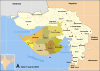
Rajkot district
Encyclopedia
India
India , officially the Republic of India , is a country in South Asia. It is the seventh-largest country by geographical area, the second-most populous country with over 1.2 billion people, and the most populous democracy in the world...
n state of Gujarat. Rajkot city is the administrative headquarters of the district. It is the third-most advanced district in Gujarat.
This district is surrounded by Kutch district
Kutch District
Kutch district is a district of Gujarat state in western India. Covering an area of 45,652 km², it is the largest district of India....
in north, Surendranagar
Surendranagar district
Surendranagar is an administrative district in the state of Gujarat in India. It has a population of approximately 1.7 million people. Surendranagar is also known as Zalawad, as the city of Surendranagar was ruled by Zala Rajputs...
and Bhavnagar
Bhavnagar district
Bhavnagar is a peninsular district of South-Eastern Gujarat. Bhavnagar city is the administrative headquarters of the district. It had a population of 2,469,630 of which 37.86% were urban as of 2001. It covers an area of over 9940 km²...
districts in east, Amreli
Amreli District
Amreli district is one of the 26 administrative districts of the state of Gujarat in western India. The district headquarters are located at Amreli. The district occupies an area of 6,760 km² and has a population of 1,393,918 of which 22.45% were urban . From Amreli district maximum number of...
and Junagadh
Junagadh district
Junagadh District is a district of the Indian state of Gujarat. Its administrative headquarters is the city of Junagadh.-Geography:The district is located on the Kathiawar peninsula in western Gujarat. It is surrounded by Rajkot District , Porbandar District , Amreli District...
districts in south and Jamnagar district
Jamnagar district
Jamnagar District is located in state of Gujarat, India on the southern coast of the Gulf of Kutch. The headquarters is in Jamnagar. The famous city of Dwarka is situated in this district. The district had a population of 1,904,278 of which 43.91% were urban as of 2001.Jamnagar is a very beautiful...
in west. The district occupies an area of 11203 km².
Origin of name
The district is named after its headquarters, Rajkot city. The name of the city of Rajkot (literally means the city of princes) was probably derived from Raju Sandhi, the co-founder of the erstwhile princely statePrincely state
A Princely State was a nominally sovereign entitity of British rule in India that was not directly governed by the British, but rather by an Indian ruler under a form of indirect rule such as suzerainty or paramountcy.-British relationship with the Princely States:India under the British Raj ...
of Rajkot in 1610.
Geography
The city is situated between 23°08' North latitude and 20º58' North latitude and 71º40' East longitude and 70º20' East longitude. Rajkot has relatively pleasant climate. The climate does not exhibit a lot of extremities. The summer spans from March to June. The temperature at this time varies between 20°C and 40°C. The rainy season spans from July to September. The average amount of rainfall received by the place is 550 mm. The winter months are October to February.Climate
Divisions
The district comprises 14 talukas. These are Maliya, Morbi, Tankara, Paddhari, Lodhika, Dhoraji, WankanerWankaner
Wankaner is a city and a municipality in Rajkot district in the Indian state of Gujarat.Wankaner has thorny plantation in the area !-Geography:Wankaner is located at . It has an average elevation of 81 metres ....
, Rajkot, Jam Kandorna, Upleta, Jetpur, Kotda Sangani, Jasdan and Gondal.
There are 11 Vidhan Sabha
Vidhan Sabha
The Vidhan Sabha or the Legislative Assembly is the lower house or the sole house of the provincial legislature in the different states of India. The same name is also used for the lower house of the legislatures for two of the union territories, Delhi and Pondicherry...
constituencies in this district: Morbi, Tankara, Wankaner, Rajkot East, Rajkot West, Rajkot South, Rajkot Rural, Jasdan, Gondal, Jetpur and Dhoraji. Tankara, Wankaner, Rajkot East, Rajkot West, Rajkot South, Rajkot Rural and Jasdan constituencies are part of Rajkot Lok Sabha constituency. Gondal, Jetpur and Dhoraji are part of Porbandar Lok Sabha constituency. Morbi is part of Kachchh Lok Sabha constituency.
Transport
Rajkot AirportRajkot Airport
-Modernisation Plans:Rajkot Urban Development Authority and Rajkot Municipal Corporation have proposed a plan to extend Rajkot airport runway from current to to accommodate larger aircraft and to provide connectivity to major cities than Mumbai to cater to a large demand from the Manufacturing...
, located near Rajkot city provides air connectivity with Mumbai
Mumbai
Mumbai , formerly known as Bombay in English, is the capital of the Indian state of Maharashtra. It is the most populous city in India, and the fourth most populous city in the world, with a total metropolitan area population of approximately 20.5 million...
. The only port of this district, the Port of Navlakhi
Port of Navlakhi
Navlakhi Port is an all-weather lighterage non-major intermediate Port. The Port is situated on the southwest end of the Gulf of Kutch in Hansthal Creek. The Port is about 45 km from Morbi and 160 km from Kandla. Navigation is permitted only during daylight hours; boats use channel buoys...
is an all-weather lighterage port located on the southwest end of the Gulf of Kutch
Gulf of Kutch
The Gulf of Kutch is an inlet of the Arabian Sea along the west coast of India, in the state of Gujarat, and renowned for extreme daily tides .The maximum depth of Gulf of Kutch is ....
.
The National Highway 8A
National Highway 8A (India)
National Highway 8A is an Indian National Highway entirely within the state of Gujarat. NH 8A links Ahmedabad with Narayan Sarovar and is long.-See also:* List of National Highways in India...
links Morbi with Kandla
Kandla
Kandla is a seaport in Kutch District of Gujarat state in western India. Located on the Gulf of Kutch, it is one of major ports on west coast. Kandla was constructed in the 1950s as the chief seaport serving western India, after the partition of India from Pakistan left the port of Karachi in...
. The National Highway 8B
National Highway 8B (India)
National Highway 8B is an Indian National Highway entirely within the state of Gujarat. NH 8B links Bamanbore to Porbandar and is long.NH 8B, for its entire length, is a part of the North-South and East-West Corridor....
connects Rajkot with Porbandar
Porbandar
Porbandar is a coastal city in the Indian state of Gujarat, perhaps best known for being the birthplace of Mahatma Gandhi and Sudama...
. The National Highway 8D
National Highway 8D (India)
National Highway 8D is a short Indian National Highway entirely within the state of Gujarat. NH 8D links Jetpur with Somnath and is long.-See also:* List of National Highways in India...
links Jetpur with Junagadh
Junagadh
Junagadh is the headquarters of Junagadh district in the Indian state of Gujarat. The city is the 7th largest in Gujarat. The city is located at the foot of the Girnar hills, 355 km south west of state capital Gandhinagar and Ahmedabad. The city is in western India. Literally translated,...
.
Demographics
According to the 2011 census2011 census of India
The 15th Indian National census was conducted in two phases, houselisting and population enumeration. Houselisting phase began on April 1, 2010 and involved collection of information about all buildings...
Rajkot district has a population
Demographics of India
The demographics of India are inclusive of the second most populous country in the world, with over 1.21 billion people , more than a sixth of the world's population. Already containing 17.5% of the world's population, India is projected to be the world's most populous country by 2025, surpassing...
of 3,799,770, roughly equal to the nation of Liberia
Liberia
Liberia , officially the Republic of Liberia, is a country in West Africa. It is bordered by Sierra Leone on the west, Guinea on the north and Côte d'Ivoire on the east. Liberia's coastline is composed of mostly mangrove forests while the more sparsely populated inland consists of forests that open...
or the US state of Oregon
Oregon
Oregon is a state in the Pacific Northwest region of the United States. It is located on the Pacific coast, with Washington to the north, California to the south, Nevada on the southeast and Idaho to the east. The Columbia and Snake rivers delineate much of Oregon's northern and eastern...
. This gives it a ranking of 68th in India (out of a total of 640
Districts of India
A district is an administrative division of an Indian state or territory. Districts are further subdivided, in some cases into Sub-Divisions, and otherwise directly into tehsils or talukas.District officials include:...
). The district has a population density of 339 PD/sqkm . Its population growth rate
Family planning in India
Family planning in India is based on efforts largely sponsored by the Indian government. In the 1965-2009 period, contraceptive usage has more than tripled and the fertility rate has more than halved , but the national fertility rate is still high enough to cause long-term population growth...
over the decade 2001-2011 was 19.87 %. Rajkot has a sex ratio
Sex ratio
Sex ratio is the ratio of males to females in a population. The primary sex ratio is the ratio at the time of conception, secondary sex ratio is the ratio at time of birth, and tertiary sex ratio is the ratio of mature organisms....
of 924 females
Women in India
The status of women in India has been subject to many great changes over the past few millennia. From equal status with men in ancient times through the low points of the medieval period, to the promotion of equal rights by many reformers, the history of women in India has been eventful...
for every 1000 males, and a literacy rate
Literacy in India
Literacy in India is key for socio-economic progress, and the Indian literacy rate grew to 74.04% in 2011 from 12% at the end of British rule in 1947. Although this was a greater than sixfold improvement, the level is well below the world average literacy rate of 84%, and India currently has the...
of 82.2 %.
It had a population of 3,169,881 of which 51.29% were urban as of 2001. The literacy rate is 74.85% (2001 census).