

Port Oneida Rural Historic District
Encyclopedia
Port Oneida Rural Historic District is part of the Sleeping Bear Dunes National Lakeshore
. It consists of a set of farms in the Leelanau Peninsula
of Northern Michigan
that are typical of Northern European settlers throughout the Midwestern United States
in the later part of the 19th century.
The district was farmed for over 100 years by local farmers of subsistence farms. The houses and fields were passed down through the families. What is represented in the district is the practice of land use, architecture and the evolution of agricultural technology common to the upper Great Lakes region
. It is very rare to find such a large collection of farms of this time period that are free from modern technology.
Port Oneida Rural Historic District has 121 buildings, 20 structures and 18 farmsteads.
The district is over 3400 acres (1,375.9 ha) of farming area preserved as it was in the late 19th century to the mid-20th century. It is the largest historic agricultural community in the United States under government ownership that is fully protected by the government.
The district has the greatest number of historic buildings and has the largest agricultural area. It is on the National Register of Historic Places
as of June, 1997. It has a "State" level of significance on the National Register.
glaciers’ last retreat. Inhabitants were initially drawn to northern Michigan
because of the fisheries and forests. Agriculture soon developed since there was longer growing seasons. Lake Michigan provided a lake effect warmth along the shoreline in this area. Cree and Ojibwa were among the Native Americans who lived in the area for generations.
The first European recorded in this region was Carsten Burfiend. He was an immigrant from Hanover, Germany in 1846. He arrived in the United States at Buffalo, New York
and first went by steamship to nearby North Manitou Island
. He came to the peninsula alone and left his wife and family in New York state.
There he built a cabin and worked as a fisherman until 1852. The U.S. Government around this time opened up the mainland of Michigan Territory to settlement. Burfriend moved and purchased 275 acres (111.3 ha) of land on the west side of Pyramid Point. He then sent for his wife and children.
Burfiend continued to work as a fisherman on mainland Michigan with his fishing boat. Also using his boat he would ferry early settlers between South Manitou Island
and North Manitou Island
from the mainland of Michigan. History records that John E. Fisher was one of his passengers going to the islands. Fisher was one of the first settlers on the mainland of northern Michigan
and a founder of Glen Arbor, Michigan.
Burfiend and his family lived in a three-story log cabin on the beach. Ultimately Lake Michigan's fierce storms forced them to move their home to the Sleeping Bear Dunes bluffs above the lake. Because of the harsh environment of the early days, Burfiend lost three of his sons to pneumonia and drowning.
Frederick and Margaretta Werner of Hanover, Germany, were close friends and possibly related to the Burfiends. They joined the Burfiends in September 1855 and settled in the area. Several other settlers came from Hanover. The 1860 census shows the population of Pyramid Point to be 87 people. They were immigrants from Germany
and Prussia
.
 Thomas Kelderhouse was a key person to Port Oneida. He developed most of the Port Oneida logging industry. Kelderhouse was born in Albany, New York
in 1821. His cargo ships traveled throughout Lake Michigan. Kelderhouse is recorded on one of his trips to have landed on South Manitou Island. He reportedly saw the mainland economic opportunities of the Michigan dense forests of white pine
. He negotiated with Burfiend and they agreed on building a dock on the shore of Lake Michigan if Burfiend provided the land. In 1862 the dock was completed. Port Oneida is named after the steamship Oneida, one of the first to stop at Burfiend's new dock.
The dock allowed the mainland’s hardwood forest to be harvested. Kelderhouse bought land and began processing cordwood to sell to passing ships for firewood. He built a sawmill near the John Burfiend farm. Port Oneida grew considerably over the next 30 years to include many commercial enterprises. Among these were a general store, a post office, a blacksmith shop and a boarding house. There were also two large barns built by other farmers. Kelderhouse owned most of the commercial buildings at Port Oneida and about half of the land on Pyramid Point. He built his home at Port Oneida. Kelderhouse also bought a gristmill
on the Crystal River from John Fisher in 1866 to process grains.
Between 1880 and 1890, the lumber industry, however, had taken most of the timber. The Great Lakes steamships by then were burning coal instead of firewood. Due to competition, such as the D.H. Day farm in Glen Haven
, Kelderhouse sold off the dock and mill by 1880. He died in 1884 which led to the demise of the family fortune.
All the original buildings at Port Oneida were abandoned by 1908. Only the Kelderhouse residence was still occupied by his family. In 1934 it was then sold to Fred Baker. The boarding house at Port Oneida was torn down in 1944. Other buildings and the apple orchard were removed by 1952. Wood of these buildings had been used to build the Burfiend pig barn and the Barratt barn.
Port Oneida area farming was difficult and harsh. The sandy soils did not produce much. Water was limited, which hindered their efforts. Potatoes were their primary cash crop. Their limited supply of grain sustained small herds of dairy cattle. Most employed themselves outside their farms to make ends meet.
Port Oneida was a close-knit ordinary farming community from the turn of the 20th century until World War II. Farmers worked together by going from farm to farm to gather and harvest seasonal crops.
of the area was generally of two stories with the bedrooms upstairs. A Michigan Basement with thick stone walls can still be found at some of these farmhouses. They were used for storing canned goods. Later years furnaces and water heaters were put in the basement instead. Typical outhouse
s that were associated with the farmhouses can be found at the Thoreson and Dechow farms.
There are several barns still existing in the district. The typical barn of the area had two stories and was used for cows and calves, especially in the winter months. Corn crib
s can be found at the Bufka, Burfiend, Dechow, Eitzen, and Thoreson farms. A granary
can still be found at the Thoreson, Dechow, and Bufka farms. A sugar house
or sugar shack is at the Oechow farm on M22. A silo
can be found at the Olsen farm on M22. A cement stave silo is located at the Dechow farm and a tile silo is at the Eitzen farm. A milk house or spring house
can be found at the Dechow farm and at the Thoreson Farm. Chicken coop
s are still found at Dechow, Thoreson and the Lawr farms.
Sleeping Bear Dunes National Lakeshore
Sleeping Bear Dunes National Lakeshore is a United States National Lakeshore located along the northwest coast of the Lower Peninsula of Michigan in Leelanau County and Benzie County....
. It consists of a set of farms in the Leelanau Peninsula
Leelanau Peninsula
The Leelanau Peninsula is a peninsula of the U.S. state of Michigan that extends about from the Lower Peninsula of Michigan into Lake Michigan. Leelanau County encompasses the entire peninsula. It is often referred to as the "little finger" of the mitten-shaped lower peninsula.Sleeping Bear Dunes...
of Northern Michigan
Northern Michigan
Northern Michigan, also known as Northern Lower Michigan , is a region of the U.S. state of Michigan...
that are typical of Northern European settlers throughout the Midwestern United States
Midwestern United States
The Midwestern United States is one of the four U.S. geographic regions defined by the United States Census Bureau, providing an official definition of the American Midwest....
in the later part of the 19th century.
The district was farmed for over 100 years by local farmers of subsistence farms. The houses and fields were passed down through the families. What is represented in the district is the practice of land use, architecture and the evolution of agricultural technology common to the upper Great Lakes region
Great Lakes region (North America)
The Great Lakes region of North America, occasionally known as the Third Coast or the Fresh Coast , includes the eight U.S. states of Illinois, Indiana, Michigan, Minnesota, New York, Ohio, Pennsylvania and Wisconsin as well as the Canadian province of Ontario...
. It is very rare to find such a large collection of farms of this time period that are free from modern technology.
Port Oneida Rural Historic District has 121 buildings, 20 structures and 18 farmsteads.
The district is over 3400 acres (1,375.9 ha) of farming area preserved as it was in the late 19th century to the mid-20th century. It is the largest historic agricultural community in the United States under government ownership that is fully protected by the government.
The district has the greatest number of historic buildings and has the largest agricultural area. It is on the National Register of Historic Places
National Register of Historic Places
The National Register of Historic Places is the United States government's official list of districts, sites, buildings, structures, and objects deemed worthy of preservation...
as of June, 1997. It has a "State" level of significance on the National Register.
History
The Leelanau Peninsula was occupied sometime soon after the Ice ageIce age
An ice age or, more precisely, glacial age, is a generic geological period of long-term reduction in the temperature of the Earth's surface and atmosphere, resulting in the presence or expansion of continental ice sheets, polar ice sheets and alpine glaciers...
glaciers’ last retreat. Inhabitants were initially drawn to northern Michigan
Northern Michigan
Northern Michigan, also known as Northern Lower Michigan , is a region of the U.S. state of Michigan...
because of the fisheries and forests. Agriculture soon developed since there was longer growing seasons. Lake Michigan provided a lake effect warmth along the shoreline in this area. Cree and Ojibwa were among the Native Americans who lived in the area for generations.
The first European recorded in this region was Carsten Burfiend. He was an immigrant from Hanover, Germany in 1846. He arrived in the United States at Buffalo, New York
Buffalo, New York
Buffalo is the second most populous city in the state of New York, after New York City. Located in Western New York on the eastern shores of Lake Erie and at the head of the Niagara River across from Fort Erie, Ontario, Buffalo is the seat of Erie County and the principal city of the...
and first went by steamship to nearby North Manitou Island
North Manitou Island
North Manitou Island is located in Lake Michigan, approximately west-northwest of Leland, Michigan. It is nearly eight miles long and over four miles wide, with of shoreline. It has a land area of 57.876 km² and has no population...
. He came to the peninsula alone and left his wife and family in New York state.
There he built a cabin and worked as a fisherman until 1852. The U.S. Government around this time opened up the mainland of Michigan Territory to settlement. Burfriend moved and purchased 275 acres (111.3 ha) of land on the west side of Pyramid Point. He then sent for his wife and children.
Burfiend continued to work as a fisherman on mainland Michigan with his fishing boat. Also using his boat he would ferry early settlers between South Manitou Island
South Manitou Island
South Manitou Island is located in Lake Michigan, approximately west of Leland, Michigan. It is part of Leelanau County and the Sleeping Bear Dunes National Lakeshore. The uninhabited island is in land area and can be accessed by a ferry service from Leland...
and North Manitou Island
North Manitou Island
North Manitou Island is located in Lake Michigan, approximately west-northwest of Leland, Michigan. It is nearly eight miles long and over four miles wide, with of shoreline. It has a land area of 57.876 km² and has no population...
from the mainland of Michigan. History records that John E. Fisher was one of his passengers going to the islands. Fisher was one of the first settlers on the mainland of northern Michigan
Northern Michigan
Northern Michigan, also known as Northern Lower Michigan , is a region of the U.S. state of Michigan...
and a founder of Glen Arbor, Michigan.
Burfiend and his family lived in a three-story log cabin on the beach. Ultimately Lake Michigan's fierce storms forced them to move their home to the Sleeping Bear Dunes bluffs above the lake. Because of the harsh environment of the early days, Burfiend lost three of his sons to pneumonia and drowning.
Frederick and Margaretta Werner of Hanover, Germany, were close friends and possibly related to the Burfiends. They joined the Burfiends in September 1855 and settled in the area. Several other settlers came from Hanover. The 1860 census shows the population of Pyramid Point to be 87 people. They were immigrants from Germany
Germany
Germany , officially the Federal Republic of Germany , is a federal parliamentary republic in Europe. The country consists of 16 states while the capital and largest city is Berlin. Germany covers an area of 357,021 km2 and has a largely temperate seasonal climate...
and Prussia
Prussia
Prussia was a German kingdom and historic state originating out of the Duchy of Prussia and the Margraviate of Brandenburg. For centuries, the House of Hohenzollern ruled Prussia, successfully expanding its size by way of an unusually well-organized and effective army. Prussia shaped the history...
.
Albany, New York
Albany is the capital city of the U.S. state of New York, the seat of Albany County, and the central city of New York's Capital District. Roughly north of New York City, Albany sits on the west bank of the Hudson River, about south of its confluence with the Mohawk River...
in 1821. His cargo ships traveled throughout Lake Michigan. Kelderhouse is recorded on one of his trips to have landed on South Manitou Island. He reportedly saw the mainland economic opportunities of the Michigan dense forests of white pine
Eastern White Pine
Pinus strobus, commonly known as the eastern white pine, is a large pine native to eastern North America, occurring from Newfoundland west to Minnesota and southeastern Manitoba, and south along the Appalachian Mountains to the northern edge of Georgia.It is occasionally known as simply white pine,...
. He negotiated with Burfiend and they agreed on building a dock on the shore of Lake Michigan if Burfiend provided the land. In 1862 the dock was completed. Port Oneida is named after the steamship Oneida, one of the first to stop at Burfiend's new dock.
The dock allowed the mainland’s hardwood forest to be harvested. Kelderhouse bought land and began processing cordwood to sell to passing ships for firewood. He built a sawmill near the John Burfiend farm. Port Oneida grew considerably over the next 30 years to include many commercial enterprises. Among these were a general store, a post office, a blacksmith shop and a boarding house. There were also two large barns built by other farmers. Kelderhouse owned most of the commercial buildings at Port Oneida and about half of the land on Pyramid Point. He built his home at Port Oneida. Kelderhouse also bought a gristmill
Gristmill
The terms gristmill or grist mill can refer either to a building in which grain is ground into flour, or to the grinding mechanism itself.- Early history :...
on the Crystal River from John Fisher in 1866 to process grains.
Between 1880 and 1890, the lumber industry, however, had taken most of the timber. The Great Lakes steamships by then were burning coal instead of firewood. Due to competition, such as the D.H. Day farm in Glen Haven
Glen Haven
Glen Haven may refer to:In Canada:*Glen Haven, Nova ScotiaIn the United States:*Glen Haven, Colorado*Glen Haven, New York*Glen Haven, Wisconsin, a town*Glen Haven , Wisconsin, an unincorporated community...
, Kelderhouse sold off the dock and mill by 1880. He died in 1884 which led to the demise of the family fortune.
All the original buildings at Port Oneida were abandoned by 1908. Only the Kelderhouse residence was still occupied by his family. In 1934 it was then sold to Fred Baker. The boarding house at Port Oneida was torn down in 1944. Other buildings and the apple orchard were removed by 1952. Wood of these buildings had been used to build the Burfiend pig barn and the Barratt barn.
Port Oneida area farming was difficult and harsh. The sandy soils did not produce much. Water was limited, which hindered their efforts. Potatoes were their primary cash crop. Their limited supply of grain sustained small herds of dairy cattle. Most employed themselves outside their farms to make ends meet.
Port Oneida was a close-knit ordinary farming community from the turn of the 20th century until World War II. Farmers worked together by going from farm to farm to gather and harvest seasonal crops.
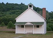
Farm Buildings Description
A typical farmhouseFarmhouse
Farmhouse is a general term for the main house of a farm. It is a type of building or house which serves a residential purpose in a rural or agricultural setting. Most often, the surrounding environment will be a farm. Many farm houses are shaped like a T...
of the area was generally of two stories with the bedrooms upstairs. A Michigan Basement with thick stone walls can still be found at some of these farmhouses. They were used for storing canned goods. Later years furnaces and water heaters were put in the basement instead. Typical outhouse
Outhouse
An outhouse is a small structure separate from a main building which often contained a simple toilet and may possibly also be used for housing animals and storage.- Terminology :...
s that were associated with the farmhouses can be found at the Thoreson and Dechow farms.
There are several barns still existing in the district. The typical barn of the area had two stories and was used for cows and calves, especially in the winter months. Corn crib
Corn crib
A corn crib or corncrib is a type of granary used to dry and store corn. It is also known as a cornhouse or corn house, though this term can refer to any granary....
s can be found at the Bufka, Burfiend, Dechow, Eitzen, and Thoreson farms. A granary
Granary
A granary is a storehouse for threshed grain or animal feed. In ancient or primitive granaries, pottery is the most common use of storage in these buildings. Granaries are often built above the ground to keep the stored food away from mice and other animals.-Early origins:From ancient times grain...
can still be found at the Thoreson, Dechow, and Bufka farms. A sugar house
Sugar house
A sugar house, also known as sap house, sugar shack, sugar shanty or sugar cabin is a semi-commercial establishment, prominent mainly in Eastern Canada...
or sugar shack is at the Oechow farm on M22. A silo
Silo
A silo is a structure for storing bulk materials.Silo may also refer to:* Silo , a 3D modeling software* Silo , a defunct chain of retail electronics stores* SILO , used in Linux...
can be found at the Olsen farm on M22. A cement stave silo is located at the Dechow farm and a tile silo is at the Eitzen farm. A milk house or spring house
Spring house
A spring house, or springhouse, is a small building used for refrigeration once commonly found in rural areas before the advent of electric refrigeration. It is usually a one-room building constructed over the source of a spring. The water of the spring maintains a constant cool temperature...
can be found at the Dechow farm and at the Thoreson Farm. Chicken coop
Chicken coop
A chicken coop is a building where female chickens are kept. Inside there are often nest boxes for egg laying and perches on which the birds can sleep, although coops for meat birds seldom have either of these features....
s are still found at Dechow, Thoreson and the Lawr farms.