
South Manitou Island
Encyclopedia
South Manitou Island is located in Lake Michigan
, approximately 16 miles (25.7 km) west of Leland
, Michigan
. It is part of Leelanau County
and the Sleeping Bear Dunes National Lakeshore
. The uninhabited island is 8.277 square miles (21.4 km²) in land area and can be accessed by a ferry service from Leland. Larger North Manitou Island
lies to its north.
 South Manitou Island was popular in the 19th and 20th centuries as a harbor and fueling station. This island was a stop for early mariners between Chicago
and the Straits of Mackinac
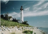
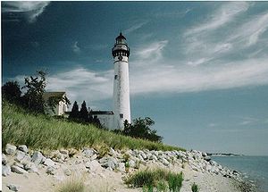
. The lighthouse
, which was in operation from 1871 to 1958, marks the finest natural harbor between Mackinac Island and Chicago. The lighthouse is still in good condition. Recent efforts have restored its light tower to operational status for the summer months.
The climate of the island provided an ideal environment for growing rye, beans, and peas, but not for getting them to a market. The island is now uninhabited, and most of its buildings lie in ruins.
In 1901, the United States Life-Saving Service
built a station on the island. The USLSS became part of the United States Coast Guard in 1915. This station is now the island's ranger station and is not open to the public.
The island is 3 miles (4.8 km) wide and 3 miles (4.8 km) long. On its west side, the island's shore is marked by perched sand dunes. Florence Lake is the island's only inland lake. The island has a system of trails and campsites. Guided tours on open-air vehicles are available to visitors, but most traffic is on foot.
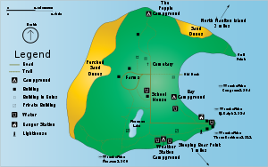 The eastern side of the island is dominated by a large round bay. This bay is deep until very close to shore. On more than one occasion, ships found here a safe port in a storm, even some of the large bulk carriers
. During the famous "Big Storm" of 1913, Captain Stufflebeam nosed his steamer's bow (the passenger/packet steamer Illinois) up onto the beach. He kept the engines going full for 49 hours so the wind would not blow the vessel back out to sea, until he was able to send two seamen ashore to fasten to a stout tree. When the storm abated 24 hours later, he let go the tree, put his engines in reverse and backed away from shore to proceed safely on his journey.
A growth of Northern white cedars on the southwestern corner of the island are among the oldest and largest in the world. The largest is 18 ft (5.5 m) around and is estimated to be over 500 years old.
The Manitou islands are surrounded by over 50 known shipwreck sites, some of which are popular diving spots. One such shipwreck is the , which grounded and became a total loss in 1960 off the south shore of the island. She ran over the wreck of the bulk freighter , stranded November 4, 1903, with a cargo of corn and general merchandise.
Lake Michigan
Lake Michigan is one of the five Great Lakes of North America and the only one located entirely within the United States. It is the second largest of the Great Lakes by volume and the third largest by surface area, after Lake Superior and Lake Huron...
, approximately 16 miles (25.7 km) west of Leland
Leland, Michigan
Leland is an unincorporated community in the U.S. state of Michigan. It was the county seat of Leelanau County from 1883 to 2008, when a new government center was completed in Suttons Bay Township, closer to the county's geographic center....
, Michigan
Michigan
Michigan is a U.S. state located in the Great Lakes Region of the United States of America. The name Michigan is the French form of the Ojibwa word mishigamaa, meaning "large water" or "large lake"....
. It is part of Leelanau County
Leelanau County, Michigan
-History:The county's name is said to be a Native American word meaning "delight of life", but it is a neologism made up by Indian agent and ethnographer Henry Schoolcraft, who sometimes gave the name "Leelinau" to Native American women in his tales. He created many faux Indian place names in...
and the Sleeping Bear Dunes National Lakeshore
Sleeping Bear Dunes National Lakeshore
Sleeping Bear Dunes National Lakeshore is a United States National Lakeshore located along the northwest coast of the Lower Peninsula of Michigan in Leelanau County and Benzie County....
. The uninhabited island is 8.277 square miles (21.4 km²) in land area and can be accessed by a ferry service from Leland. Larger North Manitou Island
North Manitou Island
North Manitou Island is located in Lake Michigan, approximately west-northwest of Leland, Michigan. It is nearly eight miles long and over four miles wide, with of shoreline. It has a land area of 57.876 km² and has no population...
lies to its north.
Chicago
Chicago is the largest city in the US state of Illinois. With nearly 2.7 million residents, it is the most populous city in the Midwestern United States and the third most populous in the US, after New York City and Los Angeles...
and the Straits of Mackinac
Straits of Mackinac
The Straits of Mackinac is the strip of water that connects two of the Great Lakes, Lake Michigan and Lake Huron, and separates the Lower Peninsula of Michigan from the Upper Peninsula of Michigan. It is a shipping lane providing passage for raw materials and finished goods, connecting, for...
. The lighthouse
South Manitou Island Light
South Manitou Island Lighthouse is located on South Manitou Island in Lake Michigan, west of Leland, Michigan. It is in Leelanau County in western Northern Michigan.-History:This is the third lighthouse built on the island...
, which was in operation from 1871 to 1958, marks the finest natural harbor between Mackinac Island and Chicago. The lighthouse is still in good condition. Recent efforts have restored its light tower to operational status for the summer months.
The climate of the island provided an ideal environment for growing rye, beans, and peas, but not for getting them to a market. The island is now uninhabited, and most of its buildings lie in ruins.
In 1901, the United States Life-Saving Service
United States Life-Saving Service
The United States Life-Saving Service was a United States government agency that grew out of private and local humanitarian efforts to save the lives of shipwrecked mariners and passengers...
built a station on the island. The USLSS became part of the United States Coast Guard in 1915. This station is now the island's ranger station and is not open to the public.
The island is 3 miles (4.8 km) wide and 3 miles (4.8 km) long. On its west side, the island's shore is marked by perched sand dunes. Florence Lake is the island's only inland lake. The island has a system of trails and campsites. Guided tours on open-air vehicles are available to visitors, but most traffic is on foot.
Lake freighter
Lake freighters, or Lakers, are bulk carrier vessels that ply the Great Lakes. The best known was the , the most recent and largest major vessel to be wrecked on the Lakes. These vessels are traditionally called boats, although classified as ships. In the mid-20th century, 300 lakers worked the...
. During the famous "Big Storm" of 1913, Captain Stufflebeam nosed his steamer's bow (the passenger/packet steamer Illinois) up onto the beach. He kept the engines going full for 49 hours so the wind would not blow the vessel back out to sea, until he was able to send two seamen ashore to fasten to a stout tree. When the storm abated 24 hours later, he let go the tree, put his engines in reverse and backed away from shore to proceed safely on his journey.
A growth of Northern white cedars on the southwestern corner of the island are among the oldest and largest in the world. The largest is 18 ft (5.5 m) around and is estimated to be over 500 years old.
The Manitou islands are surrounded by over 50 known shipwreck sites, some of which are popular diving spots. One such shipwreck is the , which grounded and became a total loss in 1960 off the south shore of the island. She ran over the wreck of the bulk freighter , stranded November 4, 1903, with a cargo of corn and general merchandise.