
Plate Boundary Observatory PBO
Encyclopedia
The Plate Boundary Observatory or (PBO) is one of three components of the Earthscope
project, along with USArray
and SAFOD (the San Andreas Fault Observatory at Depth). The PBO is exploring the structure and evolution of the North American continent and the processes related to earthquakes and volcanoes by installing an array of high precision Global Positioning System GPS monuments, borehole strainmeter
s, and tiltmeter
s throughout the western United States.
UNAVCO
, a membership-governed consortium funded by the National Science Foundation
(NSF) and NASA
, installs the PBO. Upon completion in September 2008, there will be 875 GPS stations, 103 borehole strainmeter
s, and 5 laser strainmeters throughout the western United States and Alaska
concentrated around the most active fault systems and volcanoes.
The GPS stations are categorized into five clusters. The transform cluster is in the vicinity of the San Andreas transform fault
, which cuts through California
; the subduction cluster is in the Cascadia subduction zone
, which includes northern California, Oregon
, Washington, and southern British Columbia
, and is a result of the Juan de Fuca plate
subducting under the North American plate
; the extension cluster is in the Basin and Range
region; the volcanic cluster is in volcanic regions such as the Yellowstone caldera
, the Long Valley caldera
, and the Cascade volcanoes
; the backbone cluster is at 100-200 km across the United States to provide complete spatial coverage.
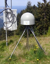
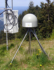 The GPS instrumentation is high-precision and continuously operating. High-precision means the units can detect sub-cm motion, and continuously operating means a 15 second sampling rate and one data file for every 24 hours. A completed PBO GPS station occupies about a three by three meter plot of land.
Some scientific questions that are being addressed by the EarthScope project and the PBO include:
Earthscope
EarthScope is an earth science program using geological and geophysical techniques to explore the structure and evolution of the North American continent and to understand the processes controlling earthquakes and volcanoes. Thousands of geophysical instruments will comprise a dense grid covering...
project, along with USArray
USARRAY
USArray is one of the three components of the Earthscope project, funded by the National Science Foundation and being constructed, operated, and maintained as a collaborative effort with UNAVCO Inc., the Incorporated Research Institutions for Seismology, and Stanford University, with contributions...
and SAFOD (the San Andreas Fault Observatory at Depth). The PBO is exploring the structure and evolution of the North American continent and the processes related to earthquakes and volcanoes by installing an array of high precision Global Positioning System GPS monuments, borehole strainmeter
Strainmeter
A strainmeter is an instrument used by geophysicists to measure thedeformation of the Earth.Linear strainmeters measure the changes in the distance between two points,using either a solid piece of material...
s, and tiltmeter
Tiltmeter
A tiltmeter is an instrument designed to measure very small changes from the horizontal level, either on the ground or in structures. A similar term, in less common usage, is the inclinometer...
s throughout the western United States.
UNAVCO
UNAVCO
UNAVCO is a non-profit membership-governed university consortium that facilitates geoscience research and education using geodesy. The UNAVCO academic and research community shares a collective vision to transform human understanding of the changing Earth by enabling the integration of innovative...
, a membership-governed consortium funded by the National Science Foundation
National Science Foundation
The National Science Foundation is a United States government agency that supports fundamental research and education in all the non-medical fields of science and engineering. Its medical counterpart is the National Institutes of Health...
(NSF) and NASA
NASA
The National Aeronautics and Space Administration is the agency of the United States government that is responsible for the nation's civilian space program and for aeronautics and aerospace research...
, installs the PBO. Upon completion in September 2008, there will be 875 GPS stations, 103 borehole strainmeter
Strainmeter
A strainmeter is an instrument used by geophysicists to measure thedeformation of the Earth.Linear strainmeters measure the changes in the distance between two points,using either a solid piece of material...
s, and 5 laser strainmeters throughout the western United States and Alaska
Alaska
Alaska is the largest state in the United States by area. It is situated in the northwest extremity of the North American continent, with Canada to the east, the Arctic Ocean to the north, and the Pacific Ocean to the west and south, with Russia further west across the Bering Strait...
concentrated around the most active fault systems and volcanoes.
The GPS stations are categorized into five clusters. The transform cluster is in the vicinity of the San Andreas transform fault
San Andreas Fault
The San Andreas Fault is a continental strike-slip fault that runs a length of roughly through California in the United States. The fault's motion is right-lateral strike-slip...
, which cuts through California
California
California is a state located on the West Coast of the United States. It is by far the most populous U.S. state, and the third-largest by land area...
; the subduction cluster is in the Cascadia subduction zone
Cascadia subduction zone
The Cascadia subduction zone is a subduction zone, a type of convergent plate boundary that stretches from northern Vancouver Island to northern California. It is a very long sloping fault that separates the Juan de Fuca and North America plates.New ocean floor is being created offshore of...
, which includes northern California, Oregon
Oregon
Oregon is a state in the Pacific Northwest region of the United States. It is located on the Pacific coast, with Washington to the north, California to the south, Nevada on the southeast and Idaho to the east. The Columbia and Snake rivers delineate much of Oregon's northern and eastern...
, Washington, and southern British Columbia
British Columbia
British Columbia is the westernmost of Canada's provinces and is known for its natural beauty, as reflected in its Latin motto, Splendor sine occasu . Its name was chosen by Queen Victoria in 1858...
, and is a result of the Juan de Fuca plate
Juan de Fuca Plate
The Juan de Fuca Plate, named after the explorer of the same name, is a tectonic plate, generated from the Juan de Fuca Ridge, and subducting under the northerly portion of the western side of the North American Plate at the Cascadia subduction zone...
subducting under the North American plate
North American Plate
The North American Plate is a tectonic plate covering most of North America, Greenland, Cuba, Bahamas, and parts of Siberia, Japan and Iceland. It extends eastward to the Mid-Atlantic Ridge and westward to the Chersky Range in eastern Siberia. The plate includes both continental and oceanic crust...
; the extension cluster is in the Basin and Range
Basin and Range
The Basin and Range Province is a vast physiographic region defined by a unique topographic expression. Basin and Range topography is characterized by abrupt changes in elevation, alternating between narrow faulted mountain chains and flat arid valleys or basins...
region; the volcanic cluster is in volcanic regions such as the Yellowstone caldera
Yellowstone Caldera
The Yellowstone Caldera is the volcanic caldera located in Yellowstone National Park in the United States, sometimes referred to as the Yellowstone Supervolcano. The caldera is located in the northwest corner of Wyoming, in which the vast majority of the park is contained. The major features of...
, the Long Valley caldera
Long Valley Caldera
Long Valley Caldera is a depression in eastern California that is adjacent to Mammoth Mountain. The valley is one of the largest calderas on earth, measuring about long and wide . The elevation of the floor of the caldera is in the east and in the west...
, and the Cascade volcanoes
Cascade Volcanoes
The Cascade Volcanoes are a number of volcanoes in a volcanic arc in western North America, extending from southwestern British Columbia through Washington and Oregon to Northern California, a distance of well over 700 mi ...
; the backbone cluster is at 100-200 km across the United States to provide complete spatial coverage.
Some scientific questions that are being addressed by the EarthScope project and the PBO include:
- How does accumulated strain lead to earthquakes?
- Are there recognizable precursors to earthquakes?
- How does the evolution of the continentContinentA continent is one of several very large landmasses on Earth. They are generally identified by convention rather than any strict criteria, with seven regions commonly regarded as continents—they are : Asia, Africa, North America, South America, Antarctica, Europe, and Australia.Plate tectonics is...
influence the motions that are happening today? - What happens to geologic structures at depth?
- What influences the location of features such as faults and mountain ranges?
- Is it inherited from earlier tectonic events or related to deeper processes in the mantleMantle (geology)The mantle is a part of a terrestrial planet or other rocky body large enough to have differentiation by density. The interior of the Earth, similar to the other terrestrial planets, is chemically divided into layers. The mantle is a highly viscous layer between the crust and the outer core....
? - How is magmaMagmaMagma is a mixture of molten rock, volatiles and solids that is found beneath the surface of the Earth, and is expected to exist on other terrestrial planets. Besides molten rock, magma may also contain suspended crystals and dissolved gas and sometimes also gas bubbles. Magma often collects in...
generated? How does it travel from the mantle to reach the surface? - What are the precursors to a volcanic eruption?