

Earthscope
Encyclopedia
Earth science
Earth science is an all-embracing term for the sciences related to the planet Earth. It is arguably a special case in planetary science, the Earth being the only known life-bearing planet. There are both reductionist and holistic approaches to Earth sciences...
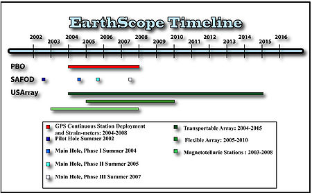
program using geological and geophysical techniques to explore the structure and evolution of the North American continent and to understand the processes controlling earthquakes and volcanoes. Thousands of geophysical instruments will comprise a dense grid covering the continental United States. Scientists from multiple disciplines have joined together to conduct research using the large influx of freely accessible data being produced. Due to recent technological advancements, funding for a project of this scale is now practical and is being provided by the National Science Foundation
National Science Foundation
The National Science Foundation is a United States government agency that supports fundamental research and education in all the non-medical fields of science and engineering. Its medical counterpart is the National Institutes of Health...
(NSF). EarthScope is being constructed, operated, and maintained in alliance with UNAVCO
UNAVCO
UNAVCO is a non-profit membership-governed university consortium that facilitates geoscience research and education using geodesy. The UNAVCO academic and research community shares a collective vision to transform human understanding of the changing Earth by enabling the integration of innovative...
, the Incorporated Research Institutions for Seismology (IRIS), Stanford University
Stanford University
The Leland Stanford Junior University, commonly referred to as Stanford University or Stanford, is a private research university on an campus located near Palo Alto, California. It is situated in the northwestern Santa Clara Valley on the San Francisco Peninsula, approximately northwest of San...
, and is conducted in partnership with the United States Geological Survey
United States Geological Survey
The United States Geological Survey is a scientific agency of the United States government. The scientists of the USGS study the landscape of the United States, its natural resources, and the natural hazards that threaten it. The organization has four major science disciplines, concerning biology,...
(USGS) and the National Aeronautics and Space Administration (NASA). Several international organizations also contribute to the initiative.
Observatories
There are three EarthScope observatories, these include the San Andreas Fault Observatory at DepthSan Andreas Fault Observatory at Depth
The San Andreas Fault Observatory at Depth is one of three components of the Earthscope Project, funded by the National Science Foundation in conjunction with the USGS and NASA. The SAFOD site is located just north of the town of Parkfield, California...
(SAFOD), the Plate Boundary Observatory
Plate Boundary Observatory PBO
The Plate Boundary Observatory or is one of three components of the Earthscope project, along with USArray and SAFOD...
(PBO), and the Seismic and Magnetotelluric Observatory
USARRAY
USArray is one of the three components of the Earthscope project, funded by the National Science Foundation and being constructed, operated, and maintained as a collaborative effort with UNAVCO Inc., the Incorporated Research Institutions for Seismology, and Stanford University, with contributions...
(USArray). These observatories consist of boreholes into an active fault
Active fault
An active fault is a fault that is likely to have another earthquake sometime in the future. Faults are commonly considered to be active if there has been movement observed or evidence of seismic activity during the last 10,000 years....
zone, global positioning system
Global Positioning System
The Global Positioning System is a space-based global navigation satellite system that provides location and time information in all weather, anywhere on or near the Earth, where there is an unobstructed line of sight to four or more GPS satellites...
(GPS) receivers, tiltmeter
Tiltmeter
A tiltmeter is an instrument designed to measure very small changes from the horizontal level, either on the ground or in structures. A similar term, in less common usage, is the inclinometer...
s, long-baseline laser strainmeter
Strainmeter
A strainmeter is an instrument used by geophysicists to measure thedeformation of the Earth.Linear strainmeters measure the changes in the distance between two points,using either a solid piece of material...
s, borehole strainmeters, permanent and portable seismographs, and magnetotelluric stations. The functionality of the EarthScope initiative serves to stimulate interest in basic geoscientific research by expanding the observational capabilities of the earth sciences and by providing real-time data that is open to the public. The various EarthScope components will provide integrated and highly accessible data on geochronology
Geochronology
Geochronology is the science of determining the age of rocks, fossils, and sediments, within a certain degree of uncertainty inherent to the method used. A variety of dating methods are used by geologists to achieve this, and schemes of classification and terminology have been proposed...
and thermochronology
Thermochronology
Thermochronology is the study of the thermal evolution of a region of a planet. Thermochronologists use radiometric dating along with the closure temperatures that represent the temperature of the mineral being studied at the time given by the date recorded, to understand the thermal history of a...
, petrology
Petrology
Petrology is the branch of geology that studies rocks, and the conditions in which rocks form....
and geochemistry
Geochemistry
The field of geochemistry involves study of the chemical composition of the Earth and other planets, chemical processes and reactions that govern the composition of rocks, water, and soils, and the cycles of matter and energy that transport the Earth's chemical components in time and space, and...
, structure and tectonics
Tectonics
Tectonics is a field of study within geology concerned generally with the structures within the lithosphere of the Earth and particularly with the forces and movements that have operated in a region to create these structures.Tectonics is concerned with the orogenies and tectonic development of...
, surficial processes and geomorphology
Geomorphology
Geomorphology is the scientific study of landforms and the processes that shape them...
, geodynamic modeling, rock physics, and hydrogeology
Hydrogeology
Hydrogeology is the area of geology that deals with the distribution and movement of groundwater in the soil and rocks of the Earth's crust, . The term geohydrology is often used interchangeably...
.
Seismic and Magnetotelluric Observatory (USArray)
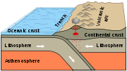
USArray, managed by IRIS, is a 15-year program to place a dense network of permanent and portable seismographs across the continental United States. These seismographs record the seismic waves released by earthquakes that occur around the world. Seismic waves are indicators of energy disbursement within the earth. By analyzing the records of earthquakes obtained from this dense grid of seismometers, scientists can learn about Earth structure and dynamics and the physical processes controlling earthquakes and volcanoes. The goal of USArray is primarily to gain a better understanding of the structure and evolution of the continental crustContinental crust
The continental crust is the layer of igneous, sedimentary, and metamorphic rocks which form the continents and the areas of shallow seabed close to their shores, known as continental shelves. This layer is sometimes called sial due to more felsic, or granitic, bulk composition, which lies in...
, lithosphere
Lithosphere
The lithosphere is the rigid outermost shell of a rocky planet. On Earth, it comprises the crust and the portion of the upper mantle that behaves elastically on time scales of thousands of years or greater.- Earth's lithosphere :...
, and mantle
Mantle (geology)
The mantle is a part of a terrestrial planet or other rocky body large enough to have differentiation by density. The interior of the Earth, similar to the other terrestrial planets, is chemically divided into layers. The mantle is a highly viscous layer between the crust and the outer core....
underneath North America.
The USArray is composed of four facilities: a Transportable Array, a Flexible Array, a Reference Network, and a Magnetotelluric Facility.
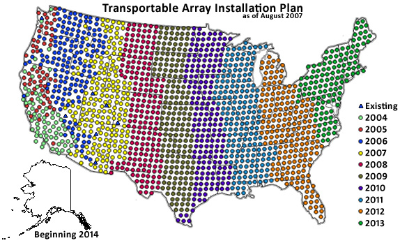
The Transportable Array is composed of 400 seismometers that are being deployed in a rolling grid across the United States over a period of 10 years. The stations are be placed 70 km apart, and can map the upper 70 km of the Earth. After approximately two years, stations are moved east to the next site on the grid–unless adopted by an organization and made a permanent installation. Once the sweep across the United States is completed, over 2000 locations will have been occupied. The Array Network Facility
Array Network Facility
The Array Network Facility component of the EarthScope USArray project is charged with ensuring all the real time seismic data collected from the Transportable Array and Flexible Arrays are transmitted, checked for quality, archived, and accessible online for researchers and the general public...
is responsible for data collection from the Transportable Array stations.
The Flexible Array is composed of 291 broadband stations, 120 short period stations, and 1700 active source stations. The Flexible Array allows sites to be targeted in a more focused manner than the broad Transportable Array. Natural or artificially created seismic waves can be used to map structures in the Earth.
The Reference Network is composed of permanent seismic stations spaced about 300 km apart. The Reference Network provides a baseline for the Transportable Array and Flexible Array. EarthScope added and upgraded 39 stations to the already existing Advanced National Seismic System, which is part of the Reference Network.
The Magnetotelluric Facility is composed of seven permanent and 20 portable sensors that record electromagnetic field
Electromagnetic field
An electromagnetic field is a physical field produced by moving electrically charged objects. It affects the behavior of charged objects in the vicinity of the field. The electromagnetic field extends indefinitely throughout space and describes the electromagnetic interaction...
s. It is the electromagnetic equivalent of the seismic arrays. The portable sensors are moved in a rolling grid similar to the Transportable Array grid, but are only in place about a month before they are moved to the next location. A magnetotelluric station consists of a magnetometer
Magnetometer
A magnetometer is a measuring instrument used to measure the strength or direction of a magnetic field either produced in the laboratory or existing in nature...
, four electrodes, and a data recording unit that are buried in shallow holes. The electrodes are oriented north-south and east-west and are saturated in a salt solution to improve conductivity with the ground.
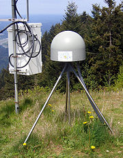
Plate Boundary Observatory (PBO)
The Plate Boundary Observatory PBO consists of a series of geodeticGeodesy
Geodesy , also named geodetics, a branch of earth sciences, is the scientific discipline that deals with the measurement and representation of the Earth, including its gravitational field, in a three-dimensional time-varying space. Geodesists also study geodynamical phenomena such as crustal...
instruments: Global Positioning System (GPS) receivers and borehole strainmeters that have been installed to help understand the boundary between the North American Plate
North American Plate
The North American Plate is a tectonic plate covering most of North America, Greenland, Cuba, Bahamas, and parts of Siberia, Japan and Iceland. It extends eastward to the Mid-Atlantic Ridge and westward to the Chersky Range in eastern Siberia. The plate includes both continental and oceanic crust...
and Pacific Plate
Pacific Plate
The Pacific Plate is an oceanic tectonic plate that lies beneath the Pacific Ocean. At 103 million square kilometres, it is the largest tectonic plate....
. The backbone includes a network of more than 130 GPS receivers that cover the western continental US, including Alaska
Alaska
Alaska is the largest state in the United States by area. It is situated in the northwest extremity of the North American continent, with Canada to the east, the Arctic Ocean to the north, and the Pacific Ocean to the west and south, with Russia further west across the Bering Strait...
, at a receiver spacing of 200 km and the eastern US at a receiver spacing of 500 km. A series of focused dense clusters of 775 permanent GPS receivers and 175 strainmeters have been installed along fault zones and volcanoes in western North America and Alaska. These permanent networks are supplemented by a pool of portable GPS receivers that can be deployed for temporary networks, to measure the crustal motion at a specific target or in response to a geologic event. The Plate Boundary Observatory portion of EarthScope is operated by UNAVCO, Inc, a non-profit organization that supports research applications of high-precision geodesy
Geodesy
Geodesy , also named geodetics, a branch of earth sciences, is the scientific discipline that deals with the measurement and representation of the Earth, including its gravitational field, in a three-dimensional time-varying space. Geodesists also study geodynamical phenomena such as crustal...
.
San Andreas Fault Observatory at Depth (SAFOD)
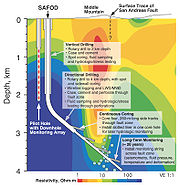
The San Andreas Fault Observatory at Depth (SAFOD) consists of a main borehole that cuts across the active San Andreas FaultSan Andreas Fault
The San Andreas Fault is a continental strike-slip fault that runs a length of roughly through California in the United States. The fault's motion is right-lateral strike-slip...
at a depth of approximately 3 km and a pilot hole about 2 km southwest of San Andreas Fault. Data from the instruments installed in the holes, which consist of geophone
Geophone
The term geophone derives from the Greek word "geo" meaning "earth" and "phone" meaning "sound".A geophone is a device which converts ground movement into voltage, which may be recorded at a recording station...
sensors, data acquisition systems, and GPS clocks, as well as samples collected during drilling, will help to better understand the processes that control the behavior of the San Andreas Fault.
Data Products
Data collected from the various observatories are used to create different types of data products. Each data product addresses a different scientific problem.P-Wave Tomography
TomographyTomography
Tomography refers to imaging by sections or sectioning, through the use of any kind of penetrating wave. A device used in tomography is called a tomograph, while the image produced is a tomogram. The method is used in radiology, archaeology, biology, geophysics, oceanography, materials science,...
is a method of producing a three-dimensional image of the internal structures of a solid object (such as the human body or the earth) by the observation and recording of differences in the effects on the passage of energy waves impinging on those structures. The waves of energy are P-waves generated by earthquakes and are recording the wave velocities. The high quality data that is being collected by the permanent seismic stations of USArray and the Advanced National Seismic System (ANSS) will allow the creation of high resolution seismic imaging of the Earth’s interior below the United States. Seismic tomography helps constrain mantle velocity structure and aids in the understanding of chemical and geodynamic processes that are at work. With the use of the data collected by USArray and global travel-time data, a global tomography model of P-wave velocity heterogeneity in the mantle can be created. The range and resolution of this technique will allow investigation into the suite of problems that are of concern in the North American mantle lithosphere, including the nature of the major tectonic features. This method gives evidence for differences in thickness and the velocity anomaly of the mantle lithosphere between the stable center of the continent and the more active western North America. This data is vital for the understanding of local lithosphere evolution, and when combined with additional global data, will allow the mantle to be imaged beyond the current extent of USArray.
Receiver Reference Models
EarthScope Automated Receiver Survey (EARS), has created a prototype of a system that will be used to address several key elements of the production of EarthScope products. One of the prototype systems is the receiver reference model. It will provide crustal thickness and average crustal Vp/Vs ratios beneath USArray transportable array stations.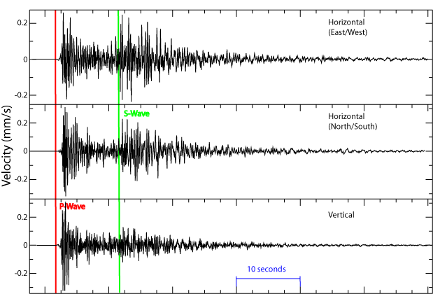
Ambient Seismic Noise
The main function of the Advanced National Seismic System (ANSS) and USArray, is to provide high quality data for earthquake monitoring, source studies and Earth structure research. The utility of seismic data is greatly increased when noise levels, unwanted vibrations, are reduced; however broadband seismograms will always contain a certain level of noise. The dominant sources of noise are either from the instrumentation itself or from ambient Earth vibrations. Normally, seismometer self noise will be well below the seismic noise level, and every station will have a characteristic noise pattern that can be calculated or observed. Sources of seismic noise within the Earth are caused by any of the following: the actions of human beings at or near the surface of the Earth, objects moved by wind with the movement being transferred to the ground, running water (river flow), surf, volcanic activity, or long period tilt due to thermal instabilities from poor station design.A new approach to seismic noise studies will be introduced with the EarthScope project, in that there are no attempts to screen the continuous waveforms to eliminate body and surface waves from the naturally occurring earthquakes. Earthquake signals are not generally included in the processing of noise data, because they are generally low probability occurrences, even at low power levels. The two objectives behind the collection of the seismic noise data are to provide and document a standard method to calculate ambient seismic background noise, and to characterize the variation of ambient background seismic noise levels across the United States as a function of geography
Geography
Geography is the science that studies the lands, features, inhabitants, and phenomena of Earth. A literal translation would be "to describe or write about the Earth". The first person to use the word "geography" was Eratosthenes...
, season, and time of day. The new statistical approach will provide the ability to compute probability density functions (PDFs) to evaluate the full range of noise at a given seismic station, allowing the estimation of noise levels over a broad range of frequencies from 0.01–16 Hz (100-0.0625s period). With the use of this new method it will be much easier to compare seismic noise characteristics between different networks in different regions.
Earthquake Ground Motion Animations
Seismometers of USArray transportable array record the passage of numerous seismic waves through a given point near the Earth’s surface, and classically these seismograms are analyzed to deduce properties of the Earth’s structure and the seismic source. Given a spatially dense set of seismic recordings, these signals can also be used to visualize the actual continuous seismic waves, providing new insights and interpretation techniques into complex wave propagation effects. Using signals recorded by the array of seismometers, the EarthScope project will be able to animate seismic waves as they sweep across the USArray transportable array for selected larger earthquakes. This will be able to illustrate the regional and teleseismic wave propagation phenomena. The seismic data collected from both permanent and transportable seismic stations will be used to provide these computer generated animations.Regional Moment Tensors
The seismic moment tensor is one of the fundamental parameters of earthquakes that can be determined from seismic observations. It is directly related to earthquake fault orientation and rupture direction. The moment magnitudeMoment magnitude scale
The moment magnitude scale is used by seismologists to measure the size of earthquakes in terms of the energy released. The magnitude is based on the seismic moment of the earthquake, which is equal to the rigidity of the Earth multiplied by the average amount of slip on the fault and the size of...
, Mw derived from the moment tensor magnitude, is the most reliable quantity for comparing and measuring the size of an earthquake with other earthquake magnitudes. Moment tensors are used in a wide range of seismological research fields, such as earthquake statistics, earthquake scaling relationships, and stress inversion. The creation of regional moment tensor solutions, with the appropriate software, for moderate-to-large earthquakes in the U.S. will be from USArray transportable array and Advance National Seismic System broadband seismic stations. Results are obtained in the time and the frequency domain. Waveform fit and amplitude-phase match figures are provided to allow users to evaluate moment tensor quality.
Geodetic Monitoring of the Western US and Hawaii
Global Positioning System (GPS) equipment and techniques provide a unique opportunity for earth scientists to study regional and local tectonic plate motions and conduct natural hazards monitoring. Cleaned network solutions from several GPS arrays have merged into regional clusters in conjunction with the EarthScope project. The arrays include the Pacific Northwest Geodetic Array, EarthScope's Plate Boundary Observatory, the Western Canadian Deformation Array, and networks run by the US Geological Survey. The daily GPS measurements from ~1500 stations along the Pacific/North American plate boundary provide millimeter-scale accuracy and can be used monitor the displacements of the earths crust. With the use of data modeling software and the recorded GPS data, the opportunity to quantify crustal deformation caused by plate tectonicsPlate tectonics
Plate tectonics is a scientific theory that describes the large scale motions of Earth's lithosphere...
, earthquakes, landslides and volcanic eruptions will be possible.
Time-dependant Strain
The goal is to provide models of time-dependant strain associated with a number of recent earthquakes and other geologic events as constrained by GPS data. With the use of InSARInsar
Insar is a town and the administrative center of Insarsky District of the Republic of Mordovia, Russia, located southwest of Saransk at the confluence of the Issa and Insarka Rivers. Population:...
(Interferometric Synthetic Aperture Radar), a remote-sensing technique, and PBO (Plate Boundary Observatory), a fixed array of GPS receivers and strainmeters, the EarthScope project will provide spatially continuous strain measurements over wide geographic areas with decimeter to centimeter resolution.
Global Strain Rate Map
The Global Strain Rate Map (GSRM) is a project of the International Lithosphere Program whose mission is to determine a globally self-consistent strain rate and velocity field model, consistent with geodetic and geologic field observations collected by GPS, seismometers, and strainmeters. GSRM is a digital model of the global velocity gradient tensor field associated with the accommodation of present-day crustal motions. The overall mission also includes: (1) contributions of global, regional, and local models by individual researchers; (2) archive existing data sets of geologic, geodetic, and seismic information that can contribute toward a greater understanding of strain phenomena; and (3) archive existing methods for modeling strain rates and strain transients. A completed global strain rate map will provide a large amount of information which will contribute to the understanding of continental dynamics and for the quantification of seismic hazards.Convergent Margin Processes
Convergent boundary
In plate tectonics, a convergent boundary, also known as a destructive plate boundary , is an actively deforming region where two tectonic plates or fragments of lithosphere move toward one another and collide...
, are active regions of deformation between two or more tectonic plates
Tectonic Plates
Tectonic Plates is a 1992 independent Canadian film directed by Peter Mettler. Mettler also wrote the screenplay based on the play by Robert Lepage. The film stars Marie Gignac, Céline Bonnier and Robert Lepage.-Plot summary:...
colliding with one another. Convergent margins create areas of tectonic uplift
Tectonic uplift
Tectonic uplift is a geological process most often caused by plate tectonics which increases elevation. The opposite of uplift is subsidence, which results in a decrease in elevation. Uplift may be orogenic or isostatic.-Orogenic uplift:...
, such as mountain ranges or volcanoes. EarthScope is focusing on the boundary between the Pacific Plate and the North American Plate in the western United States. EarthScope will provide GPS geodetic data, seismic images, detailed seismicity, magnetotelluric data, InSAR
Insar
Insar is a town and the administrative center of Insarsky District of the Republic of Mordovia, Russia, located southwest of Saransk at the confluence of the Issa and Insarka Rivers. Population:...
, stress field maps, digital elevation model
Digital elevation model
A digital elevation model is a digital model or 3-D representation of a terrain's surface — commonly for a planet , moon, or asteroid — created from terrain elevation data....
s, baseline geology, and paleoseismology
Paleoseismology
Paleoseismology looks at geologic sediments and rocks, for signs of ancient earthquakes. It is used to supplement seismic monitoring, for the calculation of seismic hazard...
for a better understanding of convergent margin processes.
A few questions hoping to be answered by EarthScope include:
- What controls the lithospheric architecture?
- What controls the locus of volcanism?
- How do convergent margin processes contribute to growth of the continent through time?
Crustal Strain and Deformation
Crustal strainStrain
Strain can refer to:* Strain , variants of plants, viruses or bacteria; or an inbred animal used for experimental purposes* Strain , a chemical stress of a molecule...
and deformation is the change in shape and volume of continental and oceanic crust caused by stress applied to rock through tectonic forces. An array of variables including composition, temperature, pressure, etc., determines how the crust will deform.
A few questions hoping to be answered by EarthScope include:
- How do crust and mantle rheologyRheologyRheology is the study of the flow of matter, primarily in the liquid state, but also as 'soft solids' or solids under conditions in which they respond with plastic flow rather than deforming elastically in response to an applied force....
vary with rock type and with depth? - How does lithospheric rheology change in the vicinity of a fault zone?
- What is the distribution of stress in the lithosphere?
Continental Deformation
Continental deformation is driven by plate interactions through active tectonic processes such as continental transform systems with extensional, strike-slip, and contractional regimes. EarthScope will provide velocity field data, portable and continuous GPS data, fault-zone drilling and sampling, reflection seismology, modern seismicity, pre-Holoscene seismicity, and magnetotelluric and potential field data for a better understanding of continental deformation.A few questions hoping to be answered by EarthScope include:
- What are the fundamental controls on deformation of the continent?
- What is the strength profile(s) of the lithosphere?
- What defines tectonic regimes within the continent?
Continent Structure and Evolution
Earth's continents are compositionally distinct from the oceanic crust. The continents record four billion years of geologic history, while the oceanic crust gets recycled about every 180 million years. Because of the age of continental crusts, the ancient structural evolution of the continents can be studied. Data from EarthScope will be used to find the mean seismic structure of the continental crust, associated mantle, and crust-mantle transition. Variability in that structure will also be studied. EarthScope will attempt to define continental lithosphere formation and continent structure and to identify the relationship between continental structure and deformation.A few questions hoping to be answered by EarthScope include:
- How does magmatism modify, enlarge, and deform continental lithosphere?
- How are the crust and lithospheric mantle related?
- What is the role of extension, orogenic collapse, and rifting in constructing the continents?
Faults and Earthquake Processes
EarthScope is acquiring 3D and 4D data that will give scientists a more detailed insight into faulting and earthquakes than ever before. This project is providing a much needed data upgrade from work done in previous years thanks to many technological advances. New data will enable an improved study and understanding of faults and earthquakes that will increase our knowledge of the complete earthquake process, allowing for the continued development of building predictive models. Detailed information on internal fault zone architecture, crust and upper mantle structure, strain rates, and transitions between fault systems and deformation types; as well as heat flow, electromagnetic/magnetotelluric, and seismic waveform data, will all be made available.A few questions hoping to be answered by EarthScope include:
- How does strain accumulate and release at plate boundaries and within the North American plate?
- How do earthquakes start, rupture, and stop?
- What is the absolute strength of faults and the surrounding lithosphere?
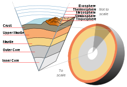
Deep Earth Structure
Through the use of seismology, scientists will be able to collect and evaluate data from the deepest parts of our planet, from the continental lithosphere down to the core. The relationship between lithospheric and the upper mantle processes is something that is not completely known, including upper mantle processes below the United States and their effects on the continental lithosphere. There are many issues of interest, such as determining the source of forces originating in the upper mantle and their effects on the continental lithosphere. Seismic data will also give scientists more understanding and insight into the lower mantle and the Earth’s core, as well as activity at the core-mantle boundaryCore-mantle boundary
The core–mantle boundary lies between the Earth's silicate mantle and its liquid iron-nickel outer core. This boundary is located at approximately 2900 km of depth beneath the Earth's surface. The boundary is observed via the discontinuity in seismic wave velocities at that depth...
.
A few questions hoping to be answered by EarthScope include:
- How is evolution of the continents linked to processes in the upper mantle?
- What is the level of heterogeneity in the mid-mantle?
- What is the nature and heterogeneity of the lower mantle and core-mantle boundary?
Fluids and Magmas
EarthScope hopes to provide a better understanding of the physics of fluids and magmas in active volcanic systems in relation to the deep Earth and how the evolution of continental lithosphere is related to upper mantle processes. The basic idea of how the various melts are formed is known, but not the volumes and rates of magmaMagma
Magma is a mixture of molten rock, volatiles and solids that is found beneath the surface of the Earth, and is expected to exist on other terrestrial planets. Besides molten rock, magma may also contain suspended crystals and dissolved gas and sometimes also gas bubbles. Magma often collects in...
production outside of Mid-ocean ridge basalts. EarthScope will provide seismic data and tomographic images of the mantle to better understand these processes.
A few questions hoping to be answered by EarthScope include:
- Over what temporal and spatial scales do earthquake deformation and volcanic eruptions couple?
- What controls eruption style?
- What are the predictive signs of imminent volcanic eruption? What are the structural, rheological, and chemical controls on fluid flow in the crust?
Education and Outreach
The Education and Outreach Program is designed to integrate EarthScope into both the classroom and the community. The program must reach out to scientific educators and students as well as industry professionals (engineers, land/resource managers, technical application/data users), partners of the project (UNAVCO, IRIS, USGS, NASA, etc.), and the general public. To accomplish this, the EOP offers a wide array of educational workshops and seminars, directed at various audiences, to offer support on data interpretation and implementation of data products into the classroom. Their job is to make sure that everyone understands what EarthScope is, what it’s doing in the community, and how to use the data it is producing. By generating new research opportunities for students in the scientific community, the program also hopes to expand recruitment for future generations of earth scientists.Mission
"To use EarthScope data, products, and results to create a measurable and lasting change on the way that Earth science is taught and perceived in the United States."Goals
- Create a high-profile public identity for EarthScope that emphasizes the integrated nature of the scientific discoveries and the importance of EarthScope research initiatives.
- Establish a sense of ownership among scientific, professional, and educational communities and the public so that a diverse group of individuals and organizations can and will make contributions to EarthScope.
- Promote science literacyScientific literacyScientific literacy encompasses written, numerical, and digital literacy as they pertain to understanding science, its methodology, observations, and theories.-Definition:...
and understanding of EarthScope among all audiences through informal education venues.
- Advance formal Earth science education by promoting inquiry-based classroom investigations that focus on understanding Earth and the interdisciplinary nature of EarthScope.
- Encourage use of EarthScope data, discoveries, and new technology in resolving challenging problems and improving our quality of life.
EarthScope In the Classroom
Education and outreach will be developing tools for educators and students across the United States to interpret and apply this information for solving a wide range of scientific issues within the earth sciences. The project tailors its products to the specified needs and requests of educators.K-12 Education
One tool that has already been put into action is the EarthScope Education and Outreach Bulletin. The bulletin, targeted for grades 5-8, summarizes a volcanic or tectonic event documented by EarthScope and puts it into an easily interpretable format, complete with diagrams and 3D models. They follow specific content standards based on what a child should be learning at those grade levels. Another is the EarthScope Voyager, Jr. which allows students to explore and visualize the various types of data that are being collected. In this interactive map, the user can add various types of base maps, features, and plate velocities. Educators have access to real time GPS data of plate movement and influences through the UNAVCO website.University Level
EarthScope promises to produce a large amount of geological and geophysical data that will open the door for numerous research opportunities in the scientific community. As the USArray Big Foot project moves across the country, universities are adopting seismic stations near their areas. These stations are then monitored and maintained by not only the professors, but their students as well. Scouting for future seismic station locations has created field work opportunities for students. The influx of data has already begun creating projects for undergraduate research, master’s thesis, and doctoral dissertations. A list of currently funded proposals can be found on the NSF website.Legacy
Aquifer
An aquifer is a wet underground layer of water-bearing permeable rock or unconsolidated materials from which groundwater can be usefully extracted using a water well. The study of water flow in aquifers and the characterization of aquifers is called hydrogeology...
boundary establishment, remote sensing
Remote sensing
Remote sensing is the acquisition of information about an object or phenomenon, without making physical contact with the object. In modern usage, the term generally refers to the use of aerial sensor technologies to detect and classify objects on Earth by means of propagated signals Remote sensing...
technique development, and earthquake risk assessment. Due to the open and free-to-the-public data portals that EarthScope and its partners maintain, the applications are limited only by the creativity of those who wish to sort through the gigabytes of data. Also, because of its scale, the program will undoubtedly be the topic of casual conversation for many people outside of the geologic community. EarthScope chatter will be made by people in political, educational, social, and scientific arenas.
Geologic Legacy
The multidisciplinary character of EarthScope will create stronger network connections between geologists of all types and from around the country. Building an Earth model of this scale requires a complex community effort, and this model is likely to be the first EarthScope legacy. Researchers analyzing the data will leave us with a greater scientific understanding of geologic resources in the Great BasinGreat Basin
The Great Basin is the largest area of contiguous endorheic watersheds in North America and is noted for its arid conditions and Basin and Range topography that varies from the North American low point at Badwater Basin to the highest point of the contiguous United States, less than away at the...
and of the evolution of the plate boundary on the North American west coast. Another geologic legacy desired by the initiative, is to invigorate the Earth sciences community. Invigoration is self-perpetuating as evidenced by participation from thousands of organizations from around the world and from all levels of students and researchers. This leads to a significantly heightened awareness within the general public, including the next cohort of prospective Earth scientists. With further evolution of the EarthScope project, there may even be opportunities to create new observatories with the greater capabilities, including extending the USArray over the Gulf of Mexico
Gulf of Mexico
The Gulf of Mexico is a partially landlocked ocean basin largely surrounded by the North American continent and the island of Cuba. It is bounded on the northeast, north and northwest by the Gulf Coast of the United States, on the southwest and south by Mexico, and on the southeast by Cuba. In...
and the Gulf of California
Gulf of California
The Gulf of California is a body of water that separates the Baja California Peninsula from the Mexican mainland...
. There is much promise for EarthScope tools and observatories, even after retirement, to be used by universities and professional geologists. These tools include the physical equipment, software invented to analyze the data, and other data and educational products initiated or inspired by EarthScope.
Political Legacy
The science produced by EarthScope and the researchers using its data products will guide lawmakers in environmental policy, hazard identification, and ultimately, federal funding of more large-scale projects like this one. Besides the three physical dimensions of North America’s structure, a fourth dimension of the continent is being described through geochronologyGeochronology
Geochronology is the science of determining the age of rocks, fossils, and sediments, within a certain degree of uncertainty inherent to the method used. A variety of dating methods are used by geologists to achieve this, and schemes of classification and terminology have been proposed...
using EarthScope data. Improving the understanding of our continent’s geologic history will allow us and future generations to more efficiently manage and utilize geologic resources and live with geologic hazards
Geologic hazards
A geologic hazard is one of several types of adverse geologic conditions capable of causing damage or loss of property and life. These hazards consist of sudden phenomena and slow phenomena:Sudden phenomena include:...
. Environmental policy
Environmental policy
Environmental policy is any [course of] action deliberately taken [or not taken] to manage human activities with a view to prevent, reduce, or mitigate harmful effects on nature and natural resources, and ensuring that man-made changes to the environment do not have harmful effects on...
laws have been the subject of some controversy since the European settlement of North America. Specifically, water and mineral rights
Mineral rights
- Mineral estate :Ownership of mineral rights is an estate in real property. Technically it is known as a mineral estate and often referred to as mineral rights...
issues have been the focus of dispute. Our representatives in Washington D.C. and the state capitals require guidance from authoritative science in drafting the soundest environmental laws for our country. The EarthScope research community is in a position to provide the most reliable course for our government to take concerning environmental policy.
Hazard identification with EarthScope is an application already in use. In fact, the Federal Emergency Management Agency
Federal Emergency Management Agency
The Federal Emergency Management Agency is an agency of the United States Department of Homeland Security, initially created by Presidential Reorganization Plan No. 1 of 1978 and implemented by two Executive Orders...
(FEMA) has awarded the Arizona Geological Survey
Arizona Geological Survey
The Arizona Geological Survey was established by the Arizona Legislature to investigate and describe the geology of Arizona and to educate and inform the public. AZGS issues numerous maps and publications, maintains a large geological library, performs geologic mapping, and assesses geologic hazards...
and its partner universities funding to adopt and maintain eight Transportable Array stations. The stations will be used to update Arizona’s earthquake risk assessment.
Social Legacy
For EarthScope to live up to its revolutionary potential in the Earth sciences, the connections between the research and the education and outreach communities must continue to be cultivated. Enhanced public outreach to museums, the National Park System, and public schools will ensure that these forward-thinking connections are fostered. National media collaboration with high-profile outlets such as Discovery ChannelDiscovery Channel
Discovery Channel is an American satellite and cable specialty channel , founded by John Hendricks and distributed by Discovery Communications. It is a publicly traded company run by CEO David Zaslav...
, Science Channel, and National Geographic will secure a lasting legacy within the social consciousness of the world. Earth science has already been promoted as a fascinating and vital modern discipline, especially in today’s “green” culture, to which EarthScope is contributing. The utter size of the EarthScope project augments the growing public awareness of the broad structure of the planet on which we live.
See also
- San Andreas Fault Observatory at DepthSan Andreas Fault Observatory at DepthThe San Andreas Fault Observatory at Depth is one of three components of the Earthscope Project, funded by the National Science Foundation in conjunction with the USGS and NASA. The SAFOD site is located just north of the town of Parkfield, California...
(SAFOD project) - Kola Superdeep BoreholeKola Superdeep BoreholeThe Kola Superdeep Borehole is the result of a scientific drilling project of the Soviet Union in Kola Peninsula. The project attempted to drill as deep as possible into the Earth's crust. Drilling began on 24 May 1970 using the Uralmash-4E, and later the Uralmash-15000 series drilling rig. A...
- German Continental Scientific Deep Drilling Program (KTB)