

Plains of San Augustin
Encyclopedia
The Plains of San Agustin (sometimes listed as the Plains of San Augustin) are found in the southwestern U.S. state
of New Mexico
in the San Agustin Basin, south of U.S. Highway 60. They are located in Catron
and Socorro
Counties, about 50 miles (80 km) west of the town of Socorro
and about 25 miles north of Reserve
. The plains extend roughly northeast-southwest, with a length of about 55 miles (88 km) and a width varying between 5-15 miles (8-24 km). The basin is bounded on the south by the Luera Mountains
and Pelona Mountain (outliers of the Black Range
); on the west by the Tularosa Mountains; on the north by the Mangas, Crosby, Datil, and Gallinas Mountains; and on the east by the San Mateo Mountains
. The Continental Divide
lies close to much of the southern and western boundaries of the plains. UFO researchers such as Stanton Friedman allege that based on witness testimony the plains are the site of a UFO crash in 1947 that occurred near the same time as the famous Roswell Incident.
, just south of the southeast edge of the Colorado Plateau
, and west of the Rio Grande Rift
Valley. The basin is a graben
(a downdropped block which subsided between parallel faults). The graben is younger than the Datil-Mogollon volcanic eruptions. The flat floor of the plains was created by a Pleistocene
lake (Lake San Agustin). Although the graben has dropped an estimated 4,000 ft., the surface relief has been reduced to about 2,000 ft. by sedimentation. A great deal of the sediments entered the San Agustin basin prior to the formation of Lake San Agustin in the last glacial period. There is no evidence of tectonic activity in the area after Lake San Agustin became extinct.
Ecologically, the plains lie near the northern end of the Chihuahuan Desert
(though the ranges surrounding the Gila River
headwaters intervene), which is dominated by shrublands.
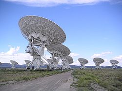
 The plains are probably best known as the site of the Very Large Array
, a radio astronomy
observatory
. The plains were chosen for the observatory because of their isolated location away from large population centers, and the partial shielding effect of the surrounding mountain ranges. The edges of the plains have sites of archaeological interest such as a prehistoric rockshelter known as Bat Cave.
Other sites in the area include a ghost town called Old Horse Springs
and the Ake Site
, a prehistoric occupation site.
U.S. state
A U.S. state is any one of the 50 federated states of the United States of America that share sovereignty with the federal government. Because of this shared sovereignty, an American is a citizen both of the federal entity and of his or her state of domicile. Four states use the official title of...
of New Mexico
New Mexico
New Mexico is a state located in the southwest and western regions of the United States. New Mexico is also usually considered one of the Mountain States. With a population density of 16 per square mile, New Mexico is the sixth-most sparsely inhabited U.S...
in the San Agustin Basin, south of U.S. Highway 60. They are located in Catron
Catron County, New Mexico
-2010:Whereas according to the 2010 U.S. Census Bureau:*89.8% White*0.4% Black*2.7% Native American*0.2% Asian*0.0% Native Hawaiian or Pacific Islander*3.1% Two or more races*3.7% Other races*19.0% Hispanic or Latino -2000:...
and Socorro
Socorro County, New Mexico
-2010:Whereas according to the 2010 U.S. Census Bureau:*75.1% White*1.1% Black*11.7% Native American*1.2% Asian*0.0% Native Hawaiian or Pacific Islander*2.8% Two or more races*8.1% Other races*48.5% Hispanic or Latino -2000:...
Counties, about 50 miles (80 km) west of the town of Socorro
Socorro, New Mexico
Socorro is a city in Socorro County in the U.S. state of New Mexico. It stands in the Rio Grande Valley at an elevation of . The population was 9,051 at the 2010 census...
and about 25 miles north of Reserve
Reserve, New Mexico
Reserve is a village in Catron County, New Mexico, United States. The population was 387 at the 2000 census. It is the county seat of Catron County. Currently the village has several stores, a bar, and a health clinic...
. The plains extend roughly northeast-southwest, with a length of about 55 miles (88 km) and a width varying between 5-15 miles (8-24 km). The basin is bounded on the south by the Luera Mountains
Luera Mountains
The Luera Mountains are a 15 mi long, mountain range in southeast Catron County, New Mexico, USA and in the central-southeast of the Plains of San Agustin...
and Pelona Mountain (outliers of the Black Range
Black Range
The Black Range is an igneous mountain range running north-south in Sierra and Grant counties in west-central New Mexico, in the southwestern United States. Its central ridge forms the western and eastern borders, respectively, of the two counties through much of their contact...
); on the west by the Tularosa Mountains; on the north by the Mangas, Crosby, Datil, and Gallinas Mountains; and on the east by the San Mateo Mountains
San Mateo Mountains (Socorro County, New Mexico)
The San Mateo Mountains are a small mountain range in Socorro County, in west-central New Mexico in the southwestern United States. The highest point in the range is West Blue Mountain, at 10,336 ft . The range runs roughly north-south and is about 40 miles long...
. The Continental Divide
Continental Divide
The Continental Divide of the Americas, or merely the Continental Gulf of Division or Great Divide, is the name given to the principal, and largely mountainous, hydrological divide of the Americas that separates the watersheds that drain into the Pacific Ocean from those river systems that drain...
lies close to much of the southern and western boundaries of the plains. UFO researchers such as Stanton Friedman allege that based on witness testimony the plains are the site of a UFO crash in 1947 that occurred near the same time as the famous Roswell Incident.
Geology
Geologically, the Plains of San Agustin lie within the Mogollon-Datil volcanic fieldMogollon-Datil volcanic field
The Mogollon-Datil volcanic field is a large silicic volcanic field in western New Mexico . It is a part of an extensive Eocene to Oligocene volcanic event which includes the San Juan volcanic field in southwestern Colorado, the Trans-Pecos volcanic field in west Texas and north central Mexico, the...
, just south of the southeast edge of the Colorado Plateau
Colorado Plateau
The Colorado Plateau, also called the Colorado Plateau Province, is a physiographic region of the Intermontane Plateaus, roughly centered on the Four Corners region of the southwestern United States. The province covers an area of 337,000 km2 within western Colorado, northwestern New Mexico,...
, and west of the Rio Grande Rift
Rio Grande Rift
The Rio Grande Rift is a north-trending continental rift zone. It separates the Colorado Plateau in the west from the interior of the North American craton on the east. The rift extends from central Colorado in the north to the state of Chihuahua, Mexico in the south. The rift zone consists of four...
Valley. The basin is a graben
Graben
In geology, a graben is a depressed block of land bordered by parallel faults. Graben is German for ditch. Graben is used for both the singular and plural....
(a downdropped block which subsided between parallel faults). The graben is younger than the Datil-Mogollon volcanic eruptions. The flat floor of the plains was created by a Pleistocene
Pleistocene
The Pleistocene is the epoch from 2,588,000 to 11,700 years BP that spans the world's recent period of repeated glaciations. The name pleistocene is derived from the Greek and ....
lake (Lake San Agustin). Although the graben has dropped an estimated 4,000 ft., the surface relief has been reduced to about 2,000 ft. by sedimentation. A great deal of the sediments entered the San Agustin basin prior to the formation of Lake San Agustin in the last glacial period. There is no evidence of tectonic activity in the area after Lake San Agustin became extinct.
Ecologically, the plains lie near the northern end of the Chihuahuan Desert
Chihuahuan Desert
The Chihuahuan Desert is a desert, and an ecoregion designation, that straddles the U.S.-Mexico border in the central and northern portions of the Mexican Plateau, bordered on the west by the extensive Sierra Madre Occidental range, and overlaying northern portions of the east range, the Sierra...
(though the ranges surrounding the Gila River
Gila River
The Gila River is a tributary of the Colorado River, 650 miles long, in the southwestern states of New Mexico and Arizona.-Description:...
headwaters intervene), which is dominated by shrublands.
Landmarks
Very Large Array
The Very Large Array is a radio astronomy observatory located on the Plains of San Agustin, between the towns of Magdalena and Datil, some fifty miles west of Socorro, New Mexico, USA...
, a radio astronomy
Radio astronomy
Radio astronomy is a subfield of astronomy that studies celestial objects at radio frequencies. The initial detection of radio waves from an astronomical object was made in the 1930s, when Karl Jansky observed radiation coming from the Milky Way. Subsequent observations have identified a number of...
observatory
Observatory
An observatory is a location used for observing terrestrial or celestial events. Astronomy, climatology/meteorology, geology, oceanography and volcanology are examples of disciplines for which observatories have been constructed...
. The plains were chosen for the observatory because of their isolated location away from large population centers, and the partial shielding effect of the surrounding mountain ranges. The edges of the plains have sites of archaeological interest such as a prehistoric rockshelter known as Bat Cave.
Other sites in the area include a ghost town called Old Horse Springs
Old Horse Springs, New Mexico
Old Horse Springs is an unincorporated community in Catron County, New Mexico, United States. It is 20 miles northeast of Aragon, and 20 miles east of Datil; to the east of Horse Springs is the Continental Divide, as well as the Plains of San Agustin....
and the Ake Site
Ake Site
The Ake Site is a name for a prehistoric archaeological location near the town of Datil in the San Augustine Basin of Catron County, New Mexico. It was listed on the New Mexico Register of Cultural Properties in 1975, and listed on the National Register of Historic Places in 1976. The Ake Site is...
, a prehistoric occupation site.
Sources
- Powers, William E. (1939) "Basin and Shore Features of the Extinct Lake, San Augustin, New Mexico" Journal of Geomorphology 2: pp. 345-356
- Weber, Robert H. (1994) "Pluvial Lakes of the Plains of San Augustin" In Chamberlin, R.M. et al. (1994) Mogollon Slope, West-Central New Mexico and East-Central Arizona pp. 9-11, New Mexico Geological Society, Forty-Fifth Annual Field Conference, Socorro, New Mexico.
- Holliday, Vance T. 'et al. (2007) "Paleoindian Geoarchaeology and the Archaeological Potential on the Plains of San Augustin, New Mexico" Argonaut Archaeological Research Fund, Department of Anthropology and Department of Geosciences, University of Arizona, Tucson, Arizona, USA
- Woodward, Susan L. (November 1996) "North American Deserts" Geography Department, Radford University, Radford, Virginia, USA