

Pierce Stocking Scenic Drive
Encyclopedia
The Pierce Stocking Scenic Drive is a scenic route within Sleeping Bear Dunes National Lakeshore
, in western Northern Michigan
in the United States. The roadway, with its "scenic vistas and gentle curves", is located off state highway M-109
between Empire
and Glen Arbor. It runs for 7.4 miles (11.9 km) through forest and dunes areas providing access to scenic overlooks of the Lake Michigan
shoreline and the surrounding park land. Interpretive markers along the roadway are keyed to the National Park Service
's guide to the drive. Over 80,000 vehicles make the trip in addition to bicyclists, hikers and skiers who use the road each year.
The road was built in the 1960s and finished in 1967 by Pierce Stocking. A lumberman with road-building experience, he wanted to share the beauty of the area with others. He operated the facility until his death in 1976; afterwards it was purchased by the National Park Service and added to the park. In the 1980s, a two-year program reconstructed the roadway and added a number of features for visiting tourists. In 2011, the morning show, Good Morning America
named the Sleeping Bear Dunes, and Pierce Stocking Drive, as the "Most Beautiful Place in America" after a viewer poll on its website; publicity since the award has increased traffic along the roadway.
 The road is a 7.4 miles (11.9 km) loop that can be driven or bicycled. Hiking the roadway is permitted, but not encouraged because of the traffic. The roadway starts at an entrance off M-109
(DH Day Highway) south of Glen Lake
. There is a parking lot inside the entrance for visitors who wish to bike or hike the road. From there, the drive continues as a two-way road to the entrance gate before turning northward as a one-way road
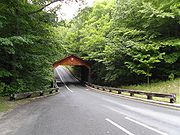
. There are 12 numbered locations along the road that are listed in the drive's interpretive brochure. The first of these is a covered bridge
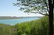
. After this point, the drive ascends a steep hill to an overlook of Glen Lake. The area around this location includes "heavily forested areas, sand plains and scrub growth among the rock outcrops". The next stop is the Dune Overlook and Picnic Mountain picnic area. From this vantage point, tourists can view both North
and South
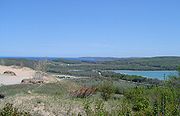
Manitou islands, also part of the park, as well as Pyramid Point and Sleeping Bear Bay. As the drive approaches this stop and the fourth, the Cottonwood Trail, it emerges from the forest into the sandy dune area next to Lake Michigan. Several more stops are noted in the guide before Pierce Stocking Scenic Drive heads back inland through the beech and maple forest.
 The roadway turns back to the shore and two overlooks next to the lake. Overlook 9 is next to the bluff on Lake Michigan, 450 feet (137.2 m) above the water, and overlook 10 is for views of the Sleeping Bear Dune. From overlook 9, visitors can see Platte Bay
some 9 miles (14.5 km) to the south on a clear day. These two locations are considered especially hazardous because of the heights involved. In 2002, the Detroit Free Press
noted that a half-dozen visitors have to be rescued by paramedics at these two overlooks after falls. The community of Glen Arbor has a special off-road vehicle
to effect rescues from the base of the cliffs. The penultimate stop along the drive is the North Bar Overlook and Picnic Area, which provides vistas of North Bar Lake. After this stop, the drive descends into maple and pine forests before coming back to the starting point. This area follows an old logging road under the forest canopy. The drive has been called "the best way to see Lake Michigan from top of the dune elevations", and "one of the nation's most fascinating landscapes".
A Park Pass fee is required for using the Pierce Stocking Scenic Drive (except for Golden Age Passport/Senior Pass
holders). A free interpretive guide for the scenic drive is available at the visitor center in Empire, Michigan, or at the entrance gate. The road is open to cars generally from the middle of April into November. During the operating system, the road is open from 9:00 a.m. to 30 minutes after sunset. After late December, the drive is used as a cross-country ski trail. The park service combines the unplowed roadway with the Shauger Hill Trail to form an eight-mile (12.8 km) system of trails of various ratings. The speed limit on the Pierce Stocking Scenic Drive is 20 mph (32 km/h). In 2008, there were 82,527 vehicles that circled the drive, a 4.7% increase over the previous year.
 The road is named after Pierce Stocking, who spent his youth working as a Michigan lumberman and used to walk these bluffs above Lake Michigan. As a lumberman he had experience building roads. Stocking began building a road to the top of the dunes in the difficult terrain around the early 1960s. According to National Geographic, Stocking was "so awed by the beauty of the dunes that ... he built the road in order to share them with visitors." The road was originally known as the Sleeping Bear Dunes Park when he first opened it to the public in 1967. He operated the scenic drive until his death in 1976, charging $2 per car (equivalent to $ in ) at the end.
The area around the roadway became part of the Sleeping Bear Dunes National Lakeshore when the park was created in 1970, and the road became part of park itself in 1977 when purchased by the park service. The name was later changed to Pierce Stocking Scenic Drive in honor the man. Starting in 1984, the National Park Service reconstructed the drive. It was paved for the first time, and a bicycle lane was added. The service also moved the entrance to the road and built the observation platforms. An original section of the road was closed because it was susceptible to drifting sands from the dunes. Stocking built the covered bridge, but the "NPS has maintained it and increased its vertical clearance to 13 feet 6 inches [13.5 feet (4.11 m)]." The renovations to the drive were completed in 1986.
In August 2011, the Sleeping Bear Dunes National Lakeshore was named by Good Morning America as the "Most Beautiful Place in America"; the designation came after a social media
campaign to capitalize on the show's website poll. Since the park was awarded the title, attendance has increased. Pierce Stocking Scenic Drive, featured in the morning show's broadcast, had 0.25 mile (0.402335 km) lines of cars waiting to get onto the drive on September 3, 2011, an uncommon sight for a day in September.
, Leelanau County
.
{| class ="wikitable"
|-
!scope="col"|Mile
!scope="col"|Number
!scope="col"|Point of interest
!scope="col"|Notes
Sleeping Bear Dunes National Lakeshore
Sleeping Bear Dunes National Lakeshore is a United States National Lakeshore located along the northwest coast of the Lower Peninsula of Michigan in Leelanau County and Benzie County....
, in western Northern Michigan
Northern Michigan
Northern Michigan, also known as Northern Lower Michigan , is a region of the U.S. state of Michigan...
in the United States. The roadway, with its "scenic vistas and gentle curves", is located off state highway M-109
M-109 (Michigan highway)
M-109 is the designation of a state trunkline highway in the Lower Peninsula of the US state of Michigan that runs between Empire and Glen Arbor...
between Empire
Empire, Michigan
Empire is a village in Leelanau County in the U.S. state of Michigan. The population was 378 at the 2000 census. The village is located within Empire Township.-Description:...
and Glen Arbor. It runs for 7.4 miles (11.9 km) through forest and dunes areas providing access to scenic overlooks of the Lake Michigan
Lake Michigan
Lake Michigan is one of the five Great Lakes of North America and the only one located entirely within the United States. It is the second largest of the Great Lakes by volume and the third largest by surface area, after Lake Superior and Lake Huron...
shoreline and the surrounding park land. Interpretive markers along the roadway are keyed to the National Park Service
National Park Service
The National Park Service is the U.S. federal agency that manages all national parks, many national monuments, and other conservation and historical properties with various title designations...
's guide to the drive. Over 80,000 vehicles make the trip in addition to bicyclists, hikers and skiers who use the road each year.
The road was built in the 1960s and finished in 1967 by Pierce Stocking. A lumberman with road-building experience, he wanted to share the beauty of the area with others. He operated the facility until his death in 1976; afterwards it was purchased by the National Park Service and added to the park. In the 1980s, a two-year program reconstructed the roadway and added a number of features for visiting tourists. In 2011, the morning show, Good Morning America
Good Morning America
Good Morning America is an American morning news and talk show that is broadcast on the ABC television network; it debuted on November 3, 1975. The weekday program airs for two hours; a third hour aired between 2007 and 2008 exclusively on ABC News Now...
named the Sleeping Bear Dunes, and Pierce Stocking Drive, as the "Most Beautiful Place in America" after a viewer poll on its website; publicity since the award has increased traffic along the roadway.
Route description
M-109 (Michigan highway)
M-109 is the designation of a state trunkline highway in the Lower Peninsula of the US state of Michigan that runs between Empire and Glen Arbor...
(DH Day Highway) south of Glen Lake
Glen Lake
Glen Lake is a lake located in Leelanau County in the U.S. state of Michigan, near Lake Michigan. Several villages and hamlets lie along or near its shore, including Burdickville, Glen Arbor, and Glen Haven...
. There is a parking lot inside the entrance for visitors who wish to bike or hike the road. From there, the drive continues as a two-way road to the entrance gate before turning northward as a one-way road
One-way traffic
One-way traffic is traffic that moves in a single direction. A one-way street is a street either facilitating only one-way traffic, or designed to direct vehicles to move in one direction.-General signs:...
. There are 12 numbered locations along the road that are listed in the drive's interpretive brochure. The first of these is a covered bridge
Covered bridge
A covered bridge is a bridge with enclosed sides and a roof, often accommodating only a single lane of traffic. Most covered bridges are wooden; some newer ones are concrete or metal with glass sides...
. After this point, the drive ascends a steep hill to an overlook of Glen Lake. The area around this location includes "heavily forested areas, sand plains and scrub growth among the rock outcrops". The next stop is the Dune Overlook and Picnic Mountain picnic area. From this vantage point, tourists can view both North
North Manitou Island
North Manitou Island is located in Lake Michigan, approximately west-northwest of Leland, Michigan. It is nearly eight miles long and over four miles wide, with of shoreline. It has a land area of 57.876 km² and has no population...
and South
South Manitou Island
South Manitou Island is located in Lake Michigan, approximately west of Leland, Michigan. It is part of Leelanau County and the Sleeping Bear Dunes National Lakeshore. The uninhabited island is in land area and can be accessed by a ferry service from Leland...
Manitou islands, also part of the park, as well as Pyramid Point and Sleeping Bear Bay. As the drive approaches this stop and the fourth, the Cottonwood Trail, it emerges from the forest into the sandy dune area next to Lake Michigan. Several more stops are noted in the guide before Pierce Stocking Scenic Drive heads back inland through the beech and maple forest.
Platte River (Michigan)
The Platte River is a short river in the northern part of the Lower Peninsula of Michigan. Its mouth is located in Sleeping Bear Dunes National Lakeshore and much of the rest is in the Pere Marquette State Forest....
some 9 miles (14.5 km) to the south on a clear day. These two locations are considered especially hazardous because of the heights involved. In 2002, the Detroit Free Press
Detroit Free Press
The Detroit Free Press is the largest daily newspaper in Detroit, Michigan, USA. The Sunday edition is entitled the Sunday Free Press. It is sometimes informally referred to as the "Freep"...
noted that a half-dozen visitors have to be rescued by paramedics at these two overlooks after falls. The community of Glen Arbor has a special off-road vehicle
Off-road vehicle
An off-road vehicle is considered to be any type of vehicle which is capable of driving on and off paved or gravel surface. It is generally characterized by having large tires with deep, open treads, a flexible suspension, or even caterpillar tracks...
to effect rescues from the base of the cliffs. The penultimate stop along the drive is the North Bar Overlook and Picnic Area, which provides vistas of North Bar Lake. After this stop, the drive descends into maple and pine forests before coming back to the starting point. This area follows an old logging road under the forest canopy. The drive has been called "the best way to see Lake Michigan from top of the dune elevations", and "one of the nation's most fascinating landscapes".
A Park Pass fee is required for using the Pierce Stocking Scenic Drive (except for Golden Age Passport/Senior Pass
Golden Age Passport
Golden Age Passport was a pass issued by the National Park Service until January 1, 2007. It has been replaced with the Senior Pass of the new pass series now called America the Beautiful - National Parks and Federal Recreational Lands Pass....
holders). A free interpretive guide for the scenic drive is available at the visitor center in Empire, Michigan, or at the entrance gate. The road is open to cars generally from the middle of April into November. During the operating system, the road is open from 9:00 a.m. to 30 minutes after sunset. After late December, the drive is used as a cross-country ski trail. The park service combines the unplowed roadway with the Shauger Hill Trail to form an eight-mile (12.8 km) system of trails of various ratings. The speed limit on the Pierce Stocking Scenic Drive is 20 mph (32 km/h). In 2008, there were 82,527 vehicles that circled the drive, a 4.7% increase over the previous year.
History
The area around the roadway became part of the Sleeping Bear Dunes National Lakeshore when the park was created in 1970, and the road became part of park itself in 1977 when purchased by the park service. The name was later changed to Pierce Stocking Scenic Drive in honor the man. Starting in 1984, the National Park Service reconstructed the drive. It was paved for the first time, and a bicycle lane was added. The service also moved the entrance to the road and built the observation platforms. An original section of the road was closed because it was susceptible to drifting sands from the dunes. Stocking built the covered bridge, but the "NPS has maintained it and increased its vertical clearance to 13 feet 6 inches [13.5 feet (4.11 m)]." The renovations to the drive were completed in 1986.
In August 2011, the Sleeping Bear Dunes National Lakeshore was named by Good Morning America as the "Most Beautiful Place in America"; the designation came after a social media
Social media
The term Social Media refers to the use of web-based and mobile technologies to turn communication into an interactive dialogue. Andreas Kaplan and Michael Haenlein define social media as "a group of Internet-based applications that build on the ideological and technological foundations of Web 2.0,...
campaign to capitalize on the show's website poll. Since the park was awarded the title, attendance has increased. Pierce Stocking Scenic Drive, featured in the morning show's broadcast, had 0.25 mile (0.402335 km) lines of cars waiting to get onto the drive on September 3, 2011, an uncommon sight for a day in September.
Points of interest
The entire roadway is in Glen Arbor TownshipGlen Arbor Township, Michigan
Glen Arbor Township is a civil township of Leelanau County in the U.S. state of Michigan. The population was 788 at the 2000 census.-Geography:...
, Leelanau County
Leelanau County, Michigan
-History:The county's name is said to be a Native American word meaning "delight of life", but it is a neologism made up by Indian agent and ethnographer Henry Schoolcraft, who sometimes gave the name "Leelinau" to Native American women in his tales. He created many faux Indian place names in...
.
{| class ="wikitable"
|-
!scope="col"|Mile
!scope="col"|Number
!scope="col"|Point of interest
!scope="col"|Notes
See also
- Brockway Mountain DriveBrockway Mountain DriveBrockway Mountain Drive is a scenic highway just west of Copper Harbor in the Upper Peninsula of Michigan in the United States. Drivers can access the road from state highway M-26 on either end near Eagle Harbor to the west or Copper Harbor to the east in the Keweenaw Peninsula...
, a scenic roadway overlooking Lake SuperiorLake SuperiorLake Superior is the largest of the five traditionally-demarcated Great Lakes of North America. It is bounded to the north by the Canadian province of Ontario and the U.S. state of Minnesota, and to the south by the U.S. states of Wisconsin and Michigan. It is the largest freshwater lake in the...
near Copper Harbor, MichiganCopper Harbor, MichiganCopper Harbor is a small unincorporated community in northeastern Keweenaw County in the U.S. state of Michigan. It is within Grant Township on the Keweenaw Peninsula that juts from the Upper Peninsula of Michigan into Lake Superior.-History:... - River Road Scenic BywayRiver Road Scenic BywayThe River Road is a National Scenic Byway in the US state of Michigan. This byway follows M-65 and River Road; it extends eastward into the Huron National Forest and ends in the historic community of Oscoda near Lake Huron. The road parallels the historic Riviere aux Sable...
, a National Scenic BywayNational Scenic BywayA National Scenic Byway is a road recognized by the United States Department of Transportation for its archeological, cultural, historic, natural, recreational, and/or scenic qualities. The program was established by Congress in 1991 to preserve and protect the nation's scenic but often...
in the Huron National Forest