
Penterry
Encyclopedia
Penterry is a small rural parish
of 479 acres (1.9 km²) in Monmouthshire
, Wales
. It is located between the villages of St. Arvans
and Tintern
, about 4 miles (6.4 km) north of Chepstow
, within the Wye Valley
Area of Outstanding Natural Beauty
and about 2 miles (3.2 km) from the border with England
. It now contains an isolated parish church
adjoining the site of a deserted village
, and a few farms.
at Gaer Hill. This provides a panoramic and strategically important view towards the Severn estuary
, and is believed to have been an Iron Age
base and lookout point for the Silures
. Because of its similarities with another monument on Holyhead Mountain
in Anglesey
, it is thought possible that the inner earthwork is a Roman
signal station lying within an earlier defensive enclosure.
Although the area is now quite remote, Penterry was originally located beside the Roman road
(locally called Piccadilly) between the Severn estuary in the south and the small fort at Blestium
, now Monmouth
. The ancient road was superseded in later centuries, other than for local traffic, by that through Devauden
to the west (now the B4293), and in the 19th century by the turnpike road through Tintern to the east (now the A466).
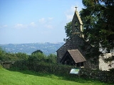
The church at Penterry is dedicated to St. Mary, and is located in an isolated position within a field. It was first mentioned in a charter in 955 AD. By the 13th century part of the parish had become a grange of nearby Tintern Abbey
. In some documents the grange is described as a Secular Firmary, suggesting that it either housed or maintained a hospital for local people. Its distance from the abbey - about 1 miles (1.6 km) - may have been to guard against the spread of infection. The present church was largely rebuilt in the mid-19th century, but retains two medieval windows and the base of a stone cross.
The area is believed to have been severely affected by the Black Death
, and a grove of trees near the church has been identified as a plague pit
. The remains of house platforms
and gardens can still be seen under the turf in the field south of the church.
The local population again declined during the 19th century, because of a fall in demand for labour to work in the nearby woods. The parish had 60 residents in 1821, but only 20 in 1911.
Civil parish
In England, a civil parish is a territorial designation and, where they are found, the lowest tier of local government below districts and counties...
of 479 acres (1.9 km²) in Monmouthshire
Monmouthshire
Monmouthshire is a county in south east Wales. The name derives from the historic county of Monmouthshire which covered a much larger area. The largest town is Abergavenny. There are many castles in Monmouthshire .-Historic county:...
, Wales
Wales
Wales is a country that is part of the United Kingdom and the island of Great Britain, bordered by England to its east and the Atlantic Ocean and Irish Sea to its west. It has a population of three million, and a total area of 20,779 km²...
. It is located between the villages of St. Arvans
St. Arvans
St. Arvans is a village in Monmouthshire, south east Wales, United Kingdom. It is located two miles north west of Chepstow, close to Chepstow Racecourse, Piercefield House and the Wye Valley AONB.-History and amenities:...
and Tintern
Tintern
Tintern is a village on the west bank of the River Wye in Monmouthshire, Wales, close to the border with England, about 5 miles north of Chepstow...
, about 4 miles (6.4 km) north of Chepstow
Chepstow
Chepstow is a town in Monmouthshire, Wales, adjoining the border with Gloucestershire, England. It is located on the River Wye, close to its confluence with the River Severn, and close to the western end of the Severn Bridge on the M48 motorway...
, within the Wye Valley
Wye Valley
The Wye Valley Area of Outstanding Natural Beauty is an internationally important protected landscape straddling the border between England and Wales. It is one of the most dramatic and scenic landscape areas in southern Britain....
Area of Outstanding Natural Beauty
Area of Outstanding Natural Beauty
An Area of Outstanding Natural Beauty is an area of countryside considered to have significant landscape value in England, Wales or Northern Ireland, that has been specially designated by the Countryside Agency on behalf of the United Kingdom government; the Countryside Council for Wales on...
and about 2 miles (3.2 km) from the border with England
England
England is a country that is part of the United Kingdom. It shares land borders with Scotland to the north and Wales to the west; the Irish Sea is to the north west, the Celtic Sea to the south west, with the North Sea to the east and the English Channel to the south separating it from continental...
. It now contains an isolated parish church
Parish church
A parish church , in Christianity, is the church which acts as the religious centre of a parish, the basic administrative unit of episcopal churches....
adjoining the site of a deserted village
Deserted Village
The Feltville Historic District, located in the Watchung Reservation, Union County, New Jersey, is a historical part of this area which still stands to this day. It includes eight houses, a church, a carriage house and a general house. Over the years this "deserted village of Feltville" has become...
, and a few farms.
History
The first evidence of human habitation in the parish is a hill fortHill fort
A hill fort is a type of earthworks used as a fortified refuge or defended settlement, located to exploit a rise in elevation for defensive advantage. They are typically European and of the Bronze and Iron Ages. Some were used in the post-Roman period...
at Gaer Hill. This provides a panoramic and strategically important view towards the Severn estuary
Severn Estuary
The Severn Estuary is the estuary of the River Severn, the longest river in Great Britain. Its high tidal range means it has been at the centre of discussions in the UK regarding renewable energy.-Geography:...
, and is believed to have been an Iron Age
Iron Age
The Iron Age is the archaeological period generally occurring after the Bronze Age, marked by the prevalent use of iron. The early period of the age is characterized by the widespread use of iron or steel. The adoption of such material coincided with other changes in society, including differing...
base and lookout point for the Silures
Silures
The Silures were a powerful and warlike tribe of ancient Britain, occupying approximately the counties of Monmouthshire, Breconshire and Glamorganshire of present day South Wales; and possibly Gloucestershire and Herefordshire of present day England...
. Because of its similarities with another monument on Holyhead Mountain
Holyhead Mountain
Holyhead Mountain is the highest hill on Holy Island, Anglesey, and the highest in the county of Anglesey, north Wales. It lies about three kilometres west of the town of Holyhead, and slopes steeply down to the Irish Sea on two sides...
in Anglesey
Anglesey
Anglesey , also known by its Welsh name Ynys Môn , is an island and, as Isle of Anglesey, a county off the north west coast of Wales...
, it is thought possible that the inner earthwork is a Roman
Roman Empire
The Roman Empire was the post-Republican period of the ancient Roman civilization, characterised by an autocratic form of government and large territorial holdings in Europe and around the Mediterranean....
signal station lying within an earlier defensive enclosure.
Although the area is now quite remote, Penterry was originally located beside the Roman road
Roman road
The Roman roads were a vital part of the development of the Roman state, from about 500 BC through the expansion during the Roman Republic and the Roman Empire. Roman roads enabled the Romans to move armies and trade goods and to communicate. The Roman road system spanned more than 400,000 km...
(locally called Piccadilly) between the Severn estuary in the south and the small fort at Blestium
Blestium
Blestium was a small town and probable fort in Roman Wales within the Roman province of Britannia Superior, part of Roman Britain...
, now Monmouth
Monmouth
Monmouth is a town in southeast Wales and traditional county town of the historic county of Monmouthshire. It is situated close to the border with England, where the River Monnow meets the River Wye with bridges over both....
. The ancient road was superseded in later centuries, other than for local traffic, by that through Devauden
Devauden
Devauden is a village in Monmouthshire, south east Wales. It is located between Chepstow and Monmouth near the top of the Trellech ridge on the B4293 road.-History:...
to the west (now the B4293), and in the 19th century by the turnpike road through Tintern to the east (now the A466).
The church at Penterry is dedicated to St. Mary, and is located in an isolated position within a field. It was first mentioned in a charter in 955 AD. By the 13th century part of the parish had become a grange of nearby Tintern Abbey
Tintern Abbey
Tintern Abbey was founded by Walter de Clare, Lord of Chepstow, on 9 May 1131. It is situated in the village of Tintern, on the Welsh bank of the River Wye in Monmouthshire, which forms the border between Monmouthshire in Wales and Gloucestershire in England. It was only the second Cistercian...
. In some documents the grange is described as a Secular Firmary, suggesting that it either housed or maintained a hospital for local people. Its distance from the abbey - about 1 miles (1.6 km) - may have been to guard against the spread of infection. The present church was largely rebuilt in the mid-19th century, but retains two medieval windows and the base of a stone cross.
The area is believed to have been severely affected by the Black Death
Black Death
The Black Death was one of the most devastating pandemics in human history, peaking in Europe between 1348 and 1350. Of several competing theories, the dominant explanation for the Black Death is the plague theory, which attributes the outbreak to the bacterium Yersinia pestis. Thought to have...
, and a grove of trees near the church has been identified as a plague pit
Plague pit
A plague pit is the informal term used to refer to mass graves in which victims of the Black Death were buried. The term is most often used to describe pits located in Great Britain, but can be applied to any place where Bubonic plague victims were buried....
. The remains of house platforms
Earthworks (archaeology)
In archaeology, earthwork is a general term to describe artificial changes in land level. Earthworks are often known colloquially as 'lumps and bumps'. Earthworks can themselves be archaeological features or they can show features beneath the surface...
and gardens can still be seen under the turf in the field south of the church.
The local population again declined during the 19th century, because of a fall in demand for labour to work in the nearby woods. The parish had 60 residents in 1821, but only 20 in 1911.