
Pennsylvania Route 739
Encyclopedia
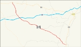
Pennsylvania Route 739 is a Pennsylvania
highway contained entirely within Pike County, Pennsylvania
. It was signed in 1967, and runs for almost 19 miles (30.6 km). Its northern terminus is at U.S. Route 6
in Blooming Grove
, running south to U.S. Route 209
in Delaware Township
. (There is some confusion regarding the official southern terminus of the highway.) PA 739's southern end marker was previously at the Dingman's Ferry Bridge
, formally ending at the New Jersey
state line over the Delaware River at Layton, New Jersey
at County Route 560
. It was moved back approximately .7 miles to the present location. This area south of Route 209 is now used by Quadrant Route 2019.
Traveling northward from the southern terminus, the highway passes through the Delaware Water Gap National Recreation Area
. The highway also contains the Route 739 Business District. Route 739 runs under the names Dingman's Pike, Glen Eyre Road and Bethany Road.
, where Sussex County Route 560
ends. The first sign that appears is for PA Route 739, which is an error, as PA 739 doesn't start for another 0.7 miles (1.1 km). The road starts by paying a toll for a bridge, which is manned by hand. PA 2019 goes through dense forests and passes its only intersection at half of a mile. PA 2019 ends at a traffic light with PA 739 and U.S. Route 209
in Dingmans Ferry
.
 The southern terminus of Route 739 is unclear. A sign marking the end of the southbound route is in place near the junction with U.S. Route 209
. However, after entering Pennsylvania via the Dingman's Ferry Bridge, there is a marker in place immediately after the bridge signing the road as northbound 739. This leads to some confusion as to what the piece of road in the southbound lane in between US 209 and the state line at New Jersey's
Sussex County Route 560
is. It is signed as Quadrant Route 2019, though most likely only for official PennDOT purposes.
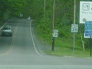 PA Route 739 begins at a traffic light with U.S. Route 209
in Dingmans Ferry
.The road starts going north through dense forests. After about 1 miles (1.6 km), Silver Lake Road (SR 2004), leaves to the left. Soon after the intersection with Sproul Road, PA 739 leaves the Delaware Water Gap National Recreation Area
. At milepost 2.45, 739 crosses a traffic light with Quadrant Route 2001, also known as Milford Road. The road continues through the dense forest and passes three of five Dingman Township schools. At 7.4 miles (11.9 km), PA 739 meets up with Quadrant Route 2006 (Log Tavern Road). PA 739 leaves Dingman Township and enters Blooming Grove Township. Continuing north, PA 739 intersects with Interstate 84
at Exit 34 (formerly Exit 9) just south of Lords Valley
. The road goes farther, crossing Quadrant Route 4004 and PA Route 434 at 14.26 miles (22.9 km). At this time, PA 739 changes names to Glen Eyre Road. PA 739 ends at an intersection with U.S. Route 6
in Blooming Grove Township
more than four miles (6 km) later. Although the 739 ends at Route 6, the Glen Eyre Road designation continues on.
 The road was designated Pennsylvania State Route 739 in 1967 and has kept the designation since then. In 1978, the road just south of Interstate 84 to two miles (3 km) north of Dingmans Ferry was paved. From 1999 and before, the intersection with PA 434 used to be with PA 1001. The road was changed to State Route 434 on the 2003 Pike County Maps. The southern designation of PA 739, State Quadrant Route 2019, first appeared on the PennDOT's maps of Pike County in 1993. That designation has existed ever since.
ordered excavation of the intersection of PA 739 and PA 2001 (Milford Road). The project was part of an $812,000 intersection improvement project, which was to be completed that summer. During the week of September 21, 2001, the work of adding advanced warning signs to the PA 739/PA 2001 intersections were added. During May 21 through May 25, 2007, lines were re-painted in Delaware Township. From the week of September 15–22, 2001, Route 739 went through some drainage work. In the year 2007, a program was started that would improve different roads around the state. There were three periods included. PA 739 was in the first period, due to finish in 2010. The project for 739 was highway restoration in curves and take about $300,000 to complete.
Pennsylvania
The Commonwealth of Pennsylvania is a U.S. state that is located in the Northeastern and Mid-Atlantic regions of the United States. The state borders Delaware and Maryland to the south, West Virginia to the southwest, Ohio to the west, New York and Ontario, Canada, to the north, and New Jersey to...
highway contained entirely within Pike County, Pennsylvania
Pike County, Pennsylvania
-National protected areas:* Delaware Water Gap National Recreation Area * Middle Delaware National Scenic River * Upper Delaware Scenic and Recreational River -Demographics:...
. It was signed in 1967, and runs for almost 19 miles (30.6 km). Its northern terminus is at U.S. Route 6
U.S. Route 6
U.S. Route 6 , also called the Grand Army of the Republic Highway, a name that honors an American Civil War veterans association, is a main route of the U.S. Highway system, running east-northeast from Bishop, California to Provincetown, Massachusetts. Until 1964, it continued south from Bishop to...
in Blooming Grove
Blooming Grove Township, Pennsylvania
Blooming Grove Township is a township in Pike County, Pennsylvania, United States. The population was 4,819 at the 2010 census. Hemlock Farms housing community is located in Blooming Grove township.-Geography:...
, running south to U.S. Route 209
U.S. Route 209
U.S. Route 209 is a long U.S. highway in the states of Pennsylvania and New York. Although the route is a spur of U.S. Route 9, US 209 never intersects US 9, making the connection via U.S. Route 9W instead. The southern terminus of the route is at Pennsylvania...
in Delaware Township
Delaware Township, Pike County, Pennsylvania
Delaware Township is a township in Pike County, Pennsylvania, United States. The population was 7,396 at the 2010 census. The Birchwood Lakes housing community is located in Delaware Township.-Geography:...
. (There is some confusion regarding the official southern terminus of the highway.) PA 739's southern end marker was previously at the Dingman's Ferry Bridge
Dingman's Ferry Bridge
The Dingman's Ferry Bridge is the last privately owned toll bridge on the Delaware River and one of the last few in the United States. It is owned and operated by the Dingmans Choice and Delaware Bridge Company.-Origins - Dingman's Ferry:...
, formally ending at the New Jersey
New Jersey
New Jersey is a state in the Northeastern and Middle Atlantic regions of the United States. , its population was 8,791,894. It is bordered on the north and east by the state of New York, on the southeast and south by the Atlantic Ocean, on the west by Pennsylvania and on the southwest by Delaware...
state line over the Delaware River at Layton, New Jersey
Layton, New Jersey
Layton is an unincorporated area located within Sandyston Township in Sussex County, New Jersey, United States. The area is served as United States Postal Service ZIP code 07851....
at County Route 560
County Route 560 (New Jersey)
County Route 560 is a county highway in the U.S. state of New Jersey. The highway extends from U.S. Route 206 and County Route 521 in Sandyston Township. Route 560 ends at the Pennsylvania state line, where it becomes Pike County Quadrant Route 2019, which connects to Pennsylvania Route 739...
. It was moved back approximately .7 miles to the present location. This area south of Route 209 is now used by Quadrant Route 2019.
Traveling northward from the southern terminus, the highway passes through the Delaware Water Gap National Recreation Area
Delaware Water Gap National Recreation Area
Delaware Water Gap National Recreation Area, administered by the National Park Service, preserves almost of land along the Delaware River's New Jersey and Pennsylvania shores, stretching from the Delaware Water Gap northward almost to the New York state line...
. The highway also contains the Route 739 Business District. Route 739 runs under the names Dingman's Pike, Glen Eyre Road and Bethany Road.
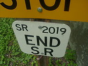
PA 2019
State Route 2019 begins at the Dingman's Ferry BridgeDingman's Ferry Bridge
The Dingman's Ferry Bridge is the last privately owned toll bridge on the Delaware River and one of the last few in the United States. It is owned and operated by the Dingmans Choice and Delaware Bridge Company.-Origins - Dingman's Ferry:...
, where Sussex County Route 560
County Route 560 (New Jersey)
County Route 560 is a county highway in the U.S. state of New Jersey. The highway extends from U.S. Route 206 and County Route 521 in Sandyston Township. Route 560 ends at the Pennsylvania state line, where it becomes Pike County Quadrant Route 2019, which connects to Pennsylvania Route 739...
ends. The first sign that appears is for PA Route 739, which is an error, as PA 739 doesn't start for another 0.7 miles (1.1 km). The road starts by paying a toll for a bridge, which is manned by hand. PA 2019 goes through dense forests and passes its only intersection at half of a mile. PA 2019 ends at a traffic light with PA 739 and U.S. Route 209
U.S. Route 209
U.S. Route 209 is a long U.S. highway in the states of Pennsylvania and New York. Although the route is a spur of U.S. Route 9, US 209 never intersects US 9, making the connection via U.S. Route 9W instead. The southern terminus of the route is at Pennsylvania...
in Dingmans Ferry
Dingmans Ferry, Pennsylvania
Dingmans Ferry is an unincorporated community in Delaware Township, Pike County, Pennsylvania, United States. It was originally sited on the Delaware River in the Delaware Water Gap National Recreation Area, but was moved farther up the mountain when the Park Service acquired the land for the...
.
U.S. Route 209
U.S. Route 209 is a long U.S. highway in the states of Pennsylvania and New York. Although the route is a spur of U.S. Route 9, US 209 never intersects US 9, making the connection via U.S. Route 9W instead. The southern terminus of the route is at Pennsylvania...
. However, after entering Pennsylvania via the Dingman's Ferry Bridge, there is a marker in place immediately after the bridge signing the road as northbound 739. This leads to some confusion as to what the piece of road in the southbound lane in between US 209 and the state line at New Jersey's
New Jersey
New Jersey is a state in the Northeastern and Middle Atlantic regions of the United States. , its population was 8,791,894. It is bordered on the north and east by the state of New York, on the southeast and south by the Atlantic Ocean, on the west by Pennsylvania and on the southwest by Delaware...
Sussex County Route 560
County Route 560 (New Jersey)
County Route 560 is a county highway in the U.S. state of New Jersey. The highway extends from U.S. Route 206 and County Route 521 in Sandyston Township. Route 560 ends at the Pennsylvania state line, where it becomes Pike County Quadrant Route 2019, which connects to Pennsylvania Route 739...
is. It is signed as Quadrant Route 2019, though most likely only for official PennDOT purposes.
PA 739
U.S. Route 209
U.S. Route 209 is a long U.S. highway in the states of Pennsylvania and New York. Although the route is a spur of U.S. Route 9, US 209 never intersects US 9, making the connection via U.S. Route 9W instead. The southern terminus of the route is at Pennsylvania...
in Dingmans Ferry
Dingmans Ferry, Pennsylvania
Dingmans Ferry is an unincorporated community in Delaware Township, Pike County, Pennsylvania, United States. It was originally sited on the Delaware River in the Delaware Water Gap National Recreation Area, but was moved farther up the mountain when the Park Service acquired the land for the...
.The road starts going north through dense forests. After about 1 miles (1.6 km), Silver Lake Road (SR 2004), leaves to the left. Soon after the intersection with Sproul Road, PA 739 leaves the Delaware Water Gap National Recreation Area
Delaware Water Gap National Recreation Area
Delaware Water Gap National Recreation Area, administered by the National Park Service, preserves almost of land along the Delaware River's New Jersey and Pennsylvania shores, stretching from the Delaware Water Gap northward almost to the New York state line...
. At milepost 2.45, 739 crosses a traffic light with Quadrant Route 2001, also known as Milford Road. The road continues through the dense forest and passes three of five Dingman Township schools. At 7.4 miles (11.9 km), PA 739 meets up with Quadrant Route 2006 (Log Tavern Road). PA 739 leaves Dingman Township and enters Blooming Grove Township. Continuing north, PA 739 intersects with Interstate 84
Interstate 84 (east)
Interstate 84 is an Interstate Highway extending from Dunmore, Pennsylvania at an interchange with Interstate 81 to Sturbridge, Massachusetts, at an interchange with the Massachusetts Turnpike . I-84 has mile-log junction numbering in Pennsylvania; otherwise, exit numbers are roughly sequential...
at Exit 34 (formerly Exit 9) just south of Lords Valley
Lords Valley, Pennsylvania
Lords Valley is an unincorporated community in Blooming Grove Township, Pike County, Pennsylvania, United States. Lords Valley is about from Milford, from Hawley, from Honesdale, from Port Jervis, New York, from Stroudsburg, and from New York City....
. The road goes farther, crossing Quadrant Route 4004 and PA Route 434 at 14.26 miles (22.9 km). At this time, PA 739 changes names to Glen Eyre Road. PA 739 ends at an intersection with U.S. Route 6
U.S. Route 6 in Pennsylvania
U.S. Route 6 travels east–west near the north edge of the U.S. state of Pennsylvania from the Ohio state line near Pymatuning Reservoir east to the Mid-Delaware Bridge over the Delaware River into Port Jervis, New York. It is the longest highway segment in the Commonwealth. Most of it is a...
in Blooming Grove Township
Blooming Grove Township, Pennsylvania
Blooming Grove Township is a township in Pike County, Pennsylvania, United States. The population was 4,819 at the 2010 census. Hemlock Farms housing community is located in Blooming Grove township.-Geography:...
more than four miles (6 km) later. Although the 739 ends at Route 6, the Glen Eyre Road designation continues on.
History
Construction
In 2003, the Pennsylvania Department of TransportationPennsylvania Department of Transportation
The Pennsylvania Department of Transportation oversees transportation issues in the Commonwealth of Pennsylvania. The administrator of PennDOT is the Pennsylvania Secretary of Transportation, currently Barry Schoch Presently, PennDOT supports over of state roads and highways, about 25,000...
ordered excavation of the intersection of PA 739 and PA 2001 (Milford Road). The project was part of an $812,000 intersection improvement project, which was to be completed that summer. During the week of September 21, 2001, the work of adding advanced warning signs to the PA 739/PA 2001 intersections were added. During May 21 through May 25, 2007, lines were re-painted in Delaware Township. From the week of September 15–22, 2001, Route 739 went through some drainage work. In the year 2007, a program was started that would improve different roads around the state. There were three periods included. PA 739 was in the first period, due to finish in 2010. The project for 739 was highway restoration in curves and take about $300,000 to complete.