

Layton, New Jersey
Encyclopedia
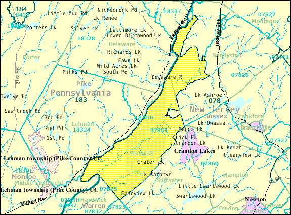
Sandyston Township, New Jersey
- Local government :Sandyston Township is governed under the Township form of government with a three-member Township Committee. The Township Committee is elected directly by the voters in partisan elections to serve three-year terms of office on a staggered basis, with one seat coming up for...
in Sussex County
Sussex County, New Jersey
The County of Sussex is the northernmost county in the State of New Jersey. It is part of the New York City Metropolitan Area. As of the 2010 Federal decennial census, 149,265 persons resided in Sussex County...
, New Jersey
New Jersey
New Jersey is a state in the Northeastern and Middle Atlantic regions of the United States. , its population was 8,791,894. It is bordered on the north and east by the state of New York, on the southeast and south by the Atlantic Ocean, on the west by Pennsylvania and on the southwest by Delaware...
, United States
United States
The United States of America is a federal constitutional republic comprising fifty states and a federal district...
. The area is served as United States Postal Service
United States Postal Service
The United States Postal Service is an independent agency of the United States government responsible for providing postal service in the United States...
ZIP code
ZIP Code
ZIP codes are a system of postal codes used by the United States Postal Service since 1963. The term ZIP, an acronym for Zone Improvement Plan, is properly written in capital letters and was chosen to suggest that the mail travels more efficiently, and therefore more quickly, when senders use the...
07851.
As of the United States 2000 Census, the population for ZIP Code Tabulation Area
ZIP Code Tabulation Area
ZIP Code Tabulation Areas are statistical entities developed by the United States Census Bureau for tabulating summary statistics from Census 2000. This new entity was developed to overcome the difficulties in precisely defining the land area covered by each ZIP code...
07851 was 250.
Layton is located 574 feet (175 m) above sea level.
The Dingman's Ferry Bridge
Dingman's Ferry Bridge
The Dingman's Ferry Bridge is the last privately owned toll bridge on the Delaware River and one of the last few in the United States. It is owned and operated by the Dingmans Choice and Delaware Bridge Company.-Origins - Dingman's Ferry:...
, crosses the Delaware River
Delaware River
The Delaware River is a major river on the Atlantic coast of the United States.A Dutch expedition led by Henry Hudson in 1609 first mapped the river. The river was christened the South River in the New Netherland colony that followed, in contrast to the North River, as the Hudson River was then...
at Layton, connecting County Route 560
County Route 560 (New Jersey)
County Route 560 is a county highway in the U.S. state of New Jersey. The highway extends from U.S. Route 206 and County Route 521 in Sandyston Township. Route 560 ends at the Pennsylvania state line, where it becomes Pike County Quadrant Route 2019, which connects to Pennsylvania Route 739...
in New Jersey to PA 739
Pennsylvania Route 739
Pennsylvania Route 739 is a Pennsylvania highway contained entirely within Pike County, Pennsylvania. It was signed in 1967, and runs for almost . Its northern terminus is at U.S. Route 6 in Blooming Grove, running south to U.S. Route 209 in Delaware Township...
in Pennsylvania
Pennsylvania
The Commonwealth of Pennsylvania is a U.S. state that is located in the Northeastern and Mid-Atlantic regions of the United States. The state borders Delaware and Maryland to the south, West Virginia to the southwest, Ohio to the west, New York and Ontario, Canada, to the north, and New Jersey to...
.
History
LAYTON [Sandyston Township] - first settled around 1800 by John Layton and was known as Centreville, the settlement is located roughly in the middle of the township at the confluence of Layton-Bevans Road (CR 640), Tuttles Corner-Dingmans Road (CR 560), and Layton-Hainesville Road (CR 645). The Little Flat Brook, which provided a source of power for early mills, runs through the middle of the village. Simeon Fisher, a blacksmith, is noted to be the first to open a business at this site, followed by Abraham Bell, who had a carpenter’s shop and a tavern. In 1835, Squire Layton established a store that served the residents of the community and travels alike. By 1860, the hamlet had significantly expanded to include a Methodist church, two stores, a post office, a tannery, a blacksmith shop, a cooperage shop, a sawmill, a small shop, a gristmill, a hotel, and more than fifteen dwellings. Shortly after that date, a one room schoolhouse was erected in the hamlet.In 1861, John B. Layton petitioned Washington, D.C. for mail delivery. The petition was in the name of Centerville, but that name was already being used by another community in the state. The name “Laytons” was assigned to this area, named for Layton who had put forth the petition. The name was later changed by the Post Office Department by dropping the ‘s’.
In 1906, the State Industrial Directory reported the village to include a gristmill, a creamery owned by Siler & Company, several residences, and population to be about one hundred. The number of residents declined to sixty by 1915. “The village occupies an exceptionally fine location with regard to healthfulness of climate and beauty of scenery. It is only two miles from the Delaware River, and a short distance from several small but fine lakes, the waters of which come from mountain streams. The elevation is 550 feet over sea level. Fish abound in all the waters about the village, and every other feature of healthful, picturesque country life, on which people who leave the cities during the summer months set a high value, are found here. “ (3)
External links
- http://factfinder.census.gov/servlet/SAFFPopulation?_event=ChangeGeoContext&geo_id=86000US07851&_geoContext=01000US%7C04000US34%7C16000US3433150&_street=&_county=&_cityTown=&_state=04000US34&_zip=07851&_lang=en&_sse=on&ActiveGeoDiv=geoSelect&_useEV=&pctxt=fph&pgsl=010&_submenuId=population_0&ds_name=null&_ci_nbr=null&qr_name=null®=null%3Anull&_keyword=&_industry=Census 2000 Fact Sheet for ZIP Code Tabulation Area 07851] from the United States Census BureauUnited States Census BureauThe United States Census Bureau is the government agency that is responsible for the United States Census. It also gathers other national demographic and economic data...