

Pennsylvania Route 320
Encyclopedia
Pennsylvania Route 320 is a north–south state highway
in southeastern Pennsylvania
. The southern terminus of the 19 miles (30.6 km) long route is at PA 291
in Chester
. The northern terminus is at PA 23
in Gladwyne
.
Before the construction of the toll-free southern portion of Interstate 476
(the "Blue Route"), Route 320 was one of the most heavily traveled north–south routes across Delaware County
and served as one of the most common feeder routes southward towards Interstate 95
and northward towards Interstate 76
. The opening of the Blue Route has alleviated some congestion on Route 320.
Route 320 follows the Blue Route for much of its length - in fact, the Blue Route passes over or under Route 320 four times: near Swarthmore, at the intersection of Sproul Road and Springfield Road near the Springfield Township/Marple Township border, at the Sproul Road/Conestoga Road intersection in Radnor Township, and near Matsonford Road in Upper Merion township. While the Blue Route has no direct interchange with the road, many of its exits are located short distances from intersections with PA 320.
 The southern terminus of Route 320 is the intersection of Madison St. and 4th Street (Pennsylvania Route 291
) in the City of Chester, Pennsylvania
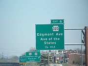
. Madison Street, a one-way northbound street, is signed as Route 320 north to East 8th street, where Route 320 turns left for two blocks along East 8th Street until Avenue of the States. Route 320 then turns right along northbound Avenue of the States for a few more blocks, then after crossing a highway overpass bridge over Interstate 95
, Route 320 forks to the right onto Providence Avenue, and Pennsylvania Route 352
continues to the northwest on Edgemont Avenue. Route 320 follows Providence Avenue northward out of the city of Chester, becoming Providence Road, and continues up to the junction of Providence Road and Chester Road. At that junction, Route 320 continues northeastward along Chester Road, while Providence Road continues northwest as Pennsylvania Route 252
.
Route 320 continues variously northeastward and northward along Chester Road through the borough of Swarthmore, Pennsylvania
, passing the Swarthmore train station
and bisecting the campus of Swarthmore College
. North of Swarthmore College, Route 320 turns left along Swarthmore Avenue for one block, then right again along Cedar Lane until its junction with Baltimore Pike
near Springfield Mall
. At this point, Route 320 takes the name Sproul Road and retains this name through various turns at intersections. It continues northward across Baltimore Pike through Springfield Township
, passing Springfield Hospital and the Springfield Golf and Country Club, and intersects the northern terminus of Pennsylvania Route 420
(Woodland Avenue). It then intersects U.S. 1
(State Road) at a diamond interchange
near the Marple Crossroads Shopping Center, then passes northward into Marple Township
.
After crossing over Interstate 476
, Route 320 merges with Springfield Road and continues northward, still signed as Sproul Road, past Cardinal O'Hara High School
and Lawrence Park Shopping Center. In Broomall
, a community in Marple Township, Route 320 turns right at the Marple Public Library and continues northeastward across West Chester Pike (Pennsylvania Route 3
), then turns left at the Marple Presbyterian Church at the western terminus of Marple Road. Route 320 continues northward through a corner of Haverford Township
, intersecting the western terminus of Darby Road, and then heads into Radnor Township
, passing the Overbrook Golf Club and Radnor Valley Country Club. It then intersects Conestoga Road near the Radnor Friends Meetinghouse underneath Interstate 476. Route 320 then continues northeastward to a junction with Spring Mill Road, and continues signed as Spring Mill Road across Lancaster Avenue (U.S. Route 30
), bisecting the campus of Villanova University
. Route 320 then passes northeastward across County Line Road, passing out of Delaware County and into Lower Merion Township
in Montgomery County
.
 One block after County Line Road, Route 320 turns left onto Montgomery Avenue, and continues along Montgomery Avenue until Matsonford Road, where the Matsonford SEPTA station
is located. The road then changes names to South Gulph Road and continues into Upper Merion Township
. It heads northward through the village of Gulph Mills
, past a large historic rock, and then intersects the Schuylkill Expressway
(Interstate 76
). After this intersection, Route 320 continues northeastward along Trinity Road, Holstein Road, and Swedeland Road until its northern terminus at Pennsylvania Route 23
(Schuylkill River Road) near the Schuylkill River
north of West Conshohocken
.
State highway
State highway, state road or state route can refer to one of three related concepts, two of them related to a state or provincial government in a country that is divided into states or provinces :#A...
in southeastern Pennsylvania
Pennsylvania
The Commonwealth of Pennsylvania is a U.S. state that is located in the Northeastern and Mid-Atlantic regions of the United States. The state borders Delaware and Maryland to the south, West Virginia to the southwest, Ohio to the west, New York and Ontario, Canada, to the north, and New Jersey to...
. The southern terminus of the 19 miles (30.6 km) long route is at PA 291
Pennsylvania Route 291
Pennsylvania Route 291 is an east–west route that connects U.S. Route 13 in the Trainer/Marcus Hook area to Interstate 76 in Southwest Philadelphia near the Walt Whitman Bridge and the South Philadelphia Sports Complex. Except for a short section between U.S. Route 13 and the...
in Chester
Chester, Pennsylvania
Chester is a city in Delaware County, Pennsylvania, United States, with a population of 33,972 at the 2010 census. Chester is situated on the Delaware River, between the cities of Philadelphia and Wilmington, Delaware.- History :...
. The northern terminus is at PA 23
Pennsylvania Route 23
Pennsylvania Route 23 is a state highway in southeastern Pennsylvania. The route begins at Pennsylvania Route 441 in Marietta and heads east to U.S. Route 1 in Philadelphia.-Marietta to Valley Forge:...
in Gladwyne
Gladwyne, Pennsylvania
Gladwyne is a suburban community in Montgomery County, Pennsylvania, United States along the Main Line. The population was 4,050 at the 2000 census...
.
Before the construction of the toll-free southern portion of Interstate 476
Interstate 476
Interstate 476 is a auxiliary Interstate Highway in the U.S. state of Pennsylvania designated between Interstate 95 near Chester and Interstate 81 near Scranton, serving as the primary north–south Interstate corridor through eastern Pennsylvania....
(the "Blue Route"), Route 320 was one of the most heavily traveled north–south routes across Delaware County
Delaware County, Pennsylvania
Delaware County is a county located in the U.S. state of Pennsylvania. As of 2010, the population was 558,979, making it Pennsylvania's fifth most populous county, behind Philadelphia, Allegheny, Montgomery, and Bucks counties....
and served as one of the most common feeder routes southward towards Interstate 95
Interstate 95 in Pennsylvania
Interstate 95 is an Interstate highway running from Miami, Florida north to Houlton, Maine. In the U.S. state of Pennsylvania, the route is known by many as the Delaware Expressway, but is officially named The Vietnam Veterans Memorial Highway. and locally known as "95"...
and northward towards Interstate 76
Interstate 76 (east)
Interstate 76 is an Interstate Highway in the United States, running 435 miles from an interchange with Interstate 71 west of Akron, Ohio, east to Interstate 295 near Camden, New Jersey....
. The opening of the Blue Route has alleviated some congestion on Route 320.
Route 320 follows the Blue Route for much of its length - in fact, the Blue Route passes over or under Route 320 four times: near Swarthmore, at the intersection of Sproul Road and Springfield Road near the Springfield Township/Marple Township border, at the Sproul Road/Conestoga Road intersection in Radnor Township, and near Matsonford Road in Upper Merion township. While the Blue Route has no direct interchange with the road, many of its exits are located short distances from intersections with PA 320.
Delaware County
Pennsylvania Route 291
Pennsylvania Route 291 is an east–west route that connects U.S. Route 13 in the Trainer/Marcus Hook area to Interstate 76 in Southwest Philadelphia near the Walt Whitman Bridge and the South Philadelphia Sports Complex. Except for a short section between U.S. Route 13 and the...
) in the City of Chester, Pennsylvania
Chester, Pennsylvania
Chester is a city in Delaware County, Pennsylvania, United States, with a population of 33,972 at the 2010 census. Chester is situated on the Delaware River, between the cities of Philadelphia and Wilmington, Delaware.- History :...
. Madison Street, a one-way northbound street, is signed as Route 320 north to East 8th street, where Route 320 turns left for two blocks along East 8th Street until Avenue of the States. Route 320 then turns right along northbound Avenue of the States for a few more blocks, then after crossing a highway overpass bridge over Interstate 95
Interstate 95 in Pennsylvania
Interstate 95 is an Interstate highway running from Miami, Florida north to Houlton, Maine. In the U.S. state of Pennsylvania, the route is known by many as the Delaware Expressway, but is officially named The Vietnam Veterans Memorial Highway. and locally known as "95"...
, Route 320 forks to the right onto Providence Avenue, and Pennsylvania Route 352
Pennsylvania Route 352
Pennsylvania Route 352 is a north–south route that begins at U.S. Route 13 in Chester and ends at U.S. Route 30 in Malvern. It is known as Middletown Road between Pennsylvania Route 452 and Pennsylvania Route 926, with the route north of Route 926 called Chester Road.- Delaware County :A few...
continues to the northwest on Edgemont Avenue. Route 320 follows Providence Avenue northward out of the city of Chester, becoming Providence Road, and continues up to the junction of Providence Road and Chester Road. At that junction, Route 320 continues northeastward along Chester Road, while Providence Road continues northwest as Pennsylvania Route 252
Pennsylvania Route 252
Pennsylvania Route 252 is a north–south route that connects at its northern terminus Pennsylvania Route 23 in Valley Forge, Pennsylvania to Pennsylvania Route 320 in Nether Providence Township, Pennsylvania at its southern terminus.-History:...
.
Route 320 continues variously northeastward and northward along Chester Road through the borough of Swarthmore, Pennsylvania
Swarthmore, Pennsylvania
Swarthmore is a borough in Delaware County, Pennsylvania, United States. Swarthmore was originally named Westdale in honor of noted painter Benjamin West, who was one of the early residents of the town. The name was changed to Swarthmore after the establishment of Swarthmore College...
, passing the Swarthmore train station
Swarthmore (SEPTA station)
Swarthmore is a station along the SEPTA Media/Elwyn Line, the former Pennsylvania Railroad West Chester Line. It is located on Chester Road between downtown Swarthmore and the edge of the Swarthmore College campus . Dollar-a-day parking and permit parking are available...
and bisecting the campus of Swarthmore College
Swarthmore College
Swarthmore College is a private, independent, liberal arts college in the United States with an enrollment of about 1,500 students. The college is located in the borough of Swarthmore, Pennsylvania, 11 miles southwest of Philadelphia....
. North of Swarthmore College, Route 320 turns left along Swarthmore Avenue for one block, then right again along Cedar Lane until its junction with Baltimore Pike
Baltimore Pike
thumb|[[SEPTA]]'s [[SEPTA Route 34|Route 34]] streetcar line runs through the 4500 block of Baltimore Avenue in [[West Philadelphia]]The Baltimore Pike was an auto trail in the United States, connecting Baltimore, Maryland with Philadelphia, Pennsylvania....
near Springfield Mall
Springfield Mall (Pennsylvania)
Springfield Mall is a regional shopping mall located approximately southwest of Philadelphia in Springfield Township, Delaware County, Pennsylvania. It is located just off of Interstate 476 along Baltimore Pike, near its busy intersection with Pennsylvania Route 320...
. At this point, Route 320 takes the name Sproul Road and retains this name through various turns at intersections. It continues northward across Baltimore Pike through Springfield Township
Springfield Township, Delaware County, Pennsylvania
Springfield Township, or simply Springfield, is a township and a Census Designated Place in Delaware County in the U.S. state of Pennsylvania. The population was 23,677 at the 2000 census...
, passing Springfield Hospital and the Springfield Golf and Country Club, and intersects the northern terminus of Pennsylvania Route 420
Pennsylvania Route 420
Pennsylvania Route 420 is a short, north–south state highway in Delaware County, Pennsylvania. The route runs from Pennsylvania Route 291 in Tinicum Township, a short distance west of the Philadelphia International Airport, to Pennsylvania Route 320 in Springfield Township.-Route...
(Woodland Avenue). It then intersects U.S. 1
U.S. Route 1 in Pennsylvania
U.S. Route 1 is a major north–south U.S. Highway, extending from the Florida Keys in the south to the Canadian border in the north. In the U.S. state of Pennsylvania, US 1 runs for from the Maryland state line near Oxford to the New Jersey state line near Trenton.-Maryland to Interstate...
(State Road) at a diamond interchange
Diamond interchange
A diamond interchange is a common type of road junction, used where a freeway crosses a minor road. The freeway itself is grade-separated from the minor road, one crossing the other over a bridge...
near the Marple Crossroads Shopping Center, then passes northward into Marple Township
Marple Township, Pennsylvania
Marple Township is a township in Delaware County, Pennsylvania, United States. The population was 23,737 at the 2000 census. ZIP codes include mainly 19008, but also partially 19064 and 19063.-Geography:...
.
After crossing over Interstate 476
Interstate 476
Interstate 476 is a auxiliary Interstate Highway in the U.S. state of Pennsylvania designated between Interstate 95 near Chester and Interstate 81 near Scranton, serving as the primary north–south Interstate corridor through eastern Pennsylvania....
, Route 320 merges with Springfield Road and continues northward, still signed as Sproul Road, past Cardinal O'Hara High School
Cardinal O'Hara High School
Cardinal O'Hara High School is a coeducational Catholic High School of the Archdiocese of Philadelphia. The school is named after John Francis O'Hara who was Archbishop of Philadelphia from 1951 to 1960. It is located in Springfield, Pennsylvania and was first opened in September 1963.- Academics...
and Lawrence Park Shopping Center. In Broomall
Broomall, Pennsylvania
Broomall is a census-designated place in Delaware County, Pennsylvania, United States. The population was 11,046 at the 2000 census. The community was named after John Martin Broomall, a 19th century U.S...
, a community in Marple Township, Route 320 turns right at the Marple Public Library and continues northeastward across West Chester Pike (Pennsylvania Route 3
Pennsylvania Route 3
Pennsylvania Route 3 is a state highway located in the southeastern portion of Pennsylvania. The route connects West Chester with Philadelphia. The divided highway that comprises much of its route is the West Chester Pike, built as a turnpike by the Philadelphia and West Chester Turnpike Company...
), then turns left at the Marple Presbyterian Church at the western terminus of Marple Road. Route 320 continues northward through a corner of Haverford Township
Haverford Township, Pennsylvania
Haverford Township is a home rule township in Delaware County, near Philadelphia, in southeastern Pennsylvania, United States. It maintains its legal name as the Township of Haverford, presumably for historic reasons...
, intersecting the western terminus of Darby Road, and then heads into Radnor Township
Radnor Township, Pennsylvania
Radnor Township is a township in Delaware County, Pennsylvania, United States. As of the 2000 census, the township population was 30,878. Radnor Township lies along the Main Line, a collection of highly affluent Philadelphia suburbs....
, passing the Overbrook Golf Club and Radnor Valley Country Club. It then intersects Conestoga Road near the Radnor Friends Meetinghouse underneath Interstate 476. Route 320 then continues northeastward to a junction with Spring Mill Road, and continues signed as Spring Mill Road across Lancaster Avenue (U.S. Route 30
U.S. Route 30 in Pennsylvania
In the U.S. state of Pennsylvania, U.S. Route 30 runs east–west across the southern part of the state, passing through Pittsburgh and Philadelphia on its way from the West Virginia state line east to the Benjamin Franklin Bridge over the Delaware River into New Jersey...
), bisecting the campus of Villanova University
Villanova University
Villanova University is a private university located in Radnor Township, a suburb northwest of Philadelphia, Pennsylvania, in the United States...
. Route 320 then passes northeastward across County Line Road, passing out of Delaware County and into Lower Merion Township
Lower Merion Township, Pennsylvania
Lower Merion Township is a township in Montgomery County, Pennsylvania and part of the Pennsylvania Main Line. As of the 2010 census, the township had a total population of 57,825...
in Montgomery County
Montgomery County, Pennsylvania
Montgomery County is a county located in the U.S. state of Pennsylvania, in the United States. As of 2010, the population was 799,874, making it the third most populous county in Pennsylvania . The county seat is Norristown.The county was created on September 10, 1784, out of land originally part...
.
Montgomery County
Matsonford (NHSL station)
Matsonford Station is an interurban rapid transit station on the SEPTA Norristown High Speed Line . The station is located at Matsonford Road and Montgomery Avenue in Lower Merion Township, Pennsylvania. Local, Hughes Park Express, and Norristown Express trains all stop at Matsonford. This station...
is located. The road then changes names to South Gulph Road and continues into Upper Merion Township
Upper Merion Township, Pennsylvania
Upper Merion Township is a township in Montgomery County, Pennsylvania, United States. The population was 28,395 at the 2010 census.Located from Philadelphia, it consists of the villages of King of Prussia, Swedeland, Swedesburg, Gulph Mills, and Wayne....
. It heads northward through the village of Gulph Mills
Gulph Mills, Pennsylvania
Gulph Mills is an unincorporated community in Upper Merion Township, Montgomery County, Pennsylvania. It is served by the Upper Merion Area School District....
, past a large historic rock, and then intersects the Schuylkill Expressway
Schuylkill Expressway
The Schuylkill Expressway , locally known as the Schuylkill, is a freeway through southwestern Montgomery County and the city of Philadelphia, and the easternmost segment of Interstate 76 in the U.S. state of Pennsylvania...
(Interstate 76
Interstate 76 (east)
Interstate 76 is an Interstate Highway in the United States, running 435 miles from an interchange with Interstate 71 west of Akron, Ohio, east to Interstate 295 near Camden, New Jersey....
). After this intersection, Route 320 continues northeastward along Trinity Road, Holstein Road, and Swedeland Road until its northern terminus at Pennsylvania Route 23
Pennsylvania Route 23
Pennsylvania Route 23 is a state highway in southeastern Pennsylvania. The route begins at Pennsylvania Route 441 in Marietta and heads east to U.S. Route 1 in Philadelphia.-Marietta to Valley Forge:...
(Schuylkill River Road) near the Schuylkill River
Schuylkill River
The Schuylkill River is a river in Pennsylvania. It is a designated Pennsylvania Scenic River.The river is about long. Its watershed of about lies entirely within the state of Pennsylvania. The source of its eastern branch is in the Appalachian Mountains at Tuscarora Springs, near Tamaqua in...
north of West Conshohocken
West Conshohocken, Pennsylvania
West Conshohocken is a borough in Montgomery County, Pennsylvania, United States. The population was 1,462 in 1880; 2,482 in 1950; 1,516 in 1980; 1,294 in 1990; and 1,320 at the 2010 census....
.