

Pennsylvania Route 232
Encyclopedia
Pennsylvania Route 232 is a 25.2 miles (40.6 km) long state highway
located in southeastern Pennsylvania
. The southern terminus of the route is at U.S. Route 1 (US 1) and US 13 at the Oxford Circle
in Philadelphia. The northern terminus is at PA 32
in the borough of New Hope
, Bucks County
, on the banks of the Delaware River
. The route passes through the urban areas of Northeast Philadelphia
as two-lane undivided Oxford Avenue, serving the Lawncrest
, Burholme
, and Fox Chase
neighborhoods. Upon entering Montgomery County
, PA 232 becomes a two- to four lane road called Huntingdon Pike that passes through suburban areas, serving the communities of Rockledge
, Huntingdon Valley
, and Bryn Athyn
. The route passes through more suburban development in Bucks County as Second Street Pike, running through Southampton
and Richboro
. In Wrightstown Township
, PA 232 enters rural areas and becomes Windy Bush Road as it heads north to New Hope.
South of Penns Park
, the road was originally known as the Fox Chase and Huntingdon Valley Turnpike or the Second Street Turnpike, a turnpike
that connected farms in Bucks County to Philadelphia. When Pennsylvania first created state highways, PA 232 was designated on its current route between PA 63
in Bethayres
and PA 32 in New Hope, while Pennsylvania Route 163 was designated onto current PA 232 between PA 73
in Philadelphia and PA 63. PA 232 was extended south along PA 163 by 1940 and to the Oxford Circle by 1960.
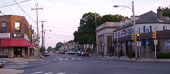 PA 232 begins at Oxford Circle
, where it intersects with Roosevelt Boulevard
(US 1
/US 13
) in Northeast Philadelphia
. The Oxford Circle is a modified traffic circle
that has direct access to the local lanes of the Roosevelt Boulevard, with the express lanes passing under it. The PA 232 bridges over the Roosevelt Bouevard were constructed in 1955 and are either structurally deficient or functionally obsolete. Here the route continues north on Oxford Avenue, a two-lane undivided surface road. The road passes through urban areas of businesses before turning northwest into areas of rowhomes. Upon reaching Har Nebo Cemetery, the route turns north through locations of homes and businesses and passes to the east of Naval Support Activity Philadelphia.
After passing the naval facility, Oxford Avenue continues northeast at the intersection with Robbins Street/Martins Mill Road. PA 232 runs north through the residential Lawncrest
neighborhood and reaches an intersection with Cottman Avenue (PA 73
) in the Burholme
neighborhood. From this junction, the route passes a mix of urban residential and commercial establishments as it comes to a 1905 bridge over CSX’s Trenton Subdivision
at the Bleigh Avenue intersection and continues into the Fox Chase
neighborhood, crossing SEPTA’s Fox Chase Line
near the Fox Chase train station
. Upon reaching the Rhawn Street intersection in the downtown area of Fox Chase, the road makes a turn to the northwest.
County in the borough of Rockledge
. Here the name of the road changes to Huntingdon Pike as it passes suburban homes and businesses. Upon intersecting Fox Chase Road/Shady Lane, the route turns north and widens to four lanes as it heads into Abington Township
. Here, the road passes between the Hollywood
neighborhood to the west and a shopping center to the east. Farther north, PA 232 runs through wooded residential areas as it comes to the Susquehanna Road intersection. The road turns northeast at this point and passes near more homes prior to running to the southeast of Holy Redeemer Hospital, at which point it widens into a divided highway
. PA 232 crosses the Pennypack Creek
and the abandoned Fox Chase-Newtown rail line on 1936 bridges as it enters Lower Moreland Township
at the Moreland Road intersection. Here, the route passes over SEPTA’s West Trenton Line
near the Bethayres Train Station
on a 1936 bridge and crosses Welsh Road/Philmont Avenue (PA 63
) in the community of Huntingdon Valley
.
Past the PA 63 intersection, PA 232 narrows into a two-lane undivided road and is lined with homes before passing a few businesses. The road continues into Bryn Athyn
and runs through wooded residential areas before passing between the Bryn Athyn Cathedral
to the west and Bryn Athyn College to the east. The route continues into less dense wooded residential development as it briefly forms the border between Lower Moreland Township to the west and Bryn Athyn to the east before fully entering Lower Moreland Township again. The road turns northeast as it passes near a few businesses at the Byberry Road intersection before heading through wooded residential subdivisions.
 PA 232 crosses County Line Road and enters Upper Southampton Township
, Bucks County
. Here, the road is named Second Street Pike and it heads north into business areas as a three lane road with a center left-turn lane, passing over Norfolk Southern’s Morrisville Line on a 1988 bridge before crossing over the Pennsylvania Turnpike
(I-276) on a 1954 bridge. The route crosses the abandoned Fox Chase-Newtown rail line again near the former Southampton Station
before intersecting Street Road (PA 132
) in the community of Southampton
.
After this intersection, the road narrows back to two lanes and turns northeast into residential areas. PA 232 makes a curve to the north as it crosses Bristol Road into Northampton Township
. The route turns northeast again and continues past more housing developments with a few businesses. At Richboro
, the road passes shopping centers and businesses as Bustleton Pike merges into Second Street Pike and PA 232 continues due north. The route widens to four lanes and passes more commercial development as it crosses PA 332
. Following the PA 332 junction, the road narrows to two lanes and passes more residential areas. As the route approaches the Sacketts Ford Road intersection, the settings become more rural as the road passes near farms and woods with some homes.
The road crosses the Neshaminy Creek
on a bridge completed in 1982 and turns northeast in Wrightstown Township
. The road continues through agricultural areas and passes to the east of a quarry following the Swamp Road intersection. PA 232 curves north again and passes a mix of rural areas and residential and commercial development prior to crossing Durham Road (PA 413
) in the community of Penns Park
. Now signed as Windy Bush Road, the road continues past wooded areas of homes. After the Pine Lane/Pineville Road intersection, the route enters Upper Makefield Township
and continues through woodland before heading into farmland.
A short distance past the Street Road intersection, PA 232 passes into Solebury Township
and crosses the Pidcock Creek on a bridge that was finished in 1930. The road continues through a mix of farms and woods with some residential areas. As the route approaches Aquetong Road, the surroundings become more forested and the road parallels Dark Hollow Run
, briefly passing through farm fields. The road enters the borough of New Hope
, where it terminates at a junction with Main Street (PA 32
).
and Bustleton Pike
. What is now PA 232 in Montgomery County was originally chartered in 1846 as the Fox Chase and Huntingdon Valley Turnpike. This road was a turnpike
that connected the Fox Chase area and ran through eastern Montgomery County to County Line Road at the Bucks County border. Further south into Philadelphia, the road was known variously as Oxford Avenue, Oxford Pike, and Oxford Turnpike. The Fox Chase and Huntingdon Valley Turnpike was also known as the Second Street Turnpike. The Second Street Pike continued the Huntington Pike north from the botder of Montgomery and Bucks counties to Wrightstown in Bucks County and served as a route for farmers into Philadelphia.
By 1930, PA 232 was designated onto its current alignment between PA 63 in Bethayres
and PA 32 in New Hope, with the current alignment between PA 63 south to PA 73 in Philadelphia designated as PA 163. PA 232 was extended south to replace PA 163 by 1940. The route was extended further south down Oxford Avenue to the Oxford Circle by 1960. Since then, there have been no alignment changes to PA 232.
State highway
State highway, state road or state route can refer to one of three related concepts, two of them related to a state or provincial government in a country that is divided into states or provinces :#A...
located in southeastern Pennsylvania
Pennsylvania
The Commonwealth of Pennsylvania is a U.S. state that is located in the Northeastern and Mid-Atlantic regions of the United States. The state borders Delaware and Maryland to the south, West Virginia to the southwest, Ohio to the west, New York and Ontario, Canada, to the north, and New Jersey to...
. The southern terminus of the route is at U.S. Route 1 (US 1) and US 13 at the Oxford Circle
Oxford Circle, Philadelphia, Pennsylvania
Oxford Circle is a neighborhood in the lower Northeast section of Philadelphia, Pennsylvania, United States. Its namesake is the much used traffic circle...
in Philadelphia. The northern terminus is at PA 32
Pennsylvania Route 32
Pennsylvania Route 32 is a scenic two-lane highway that runs along the side of the Delaware River in Bucks County, Pennsylvania. It begins at U.S. 1 in Falls Township and ends at Pennsylvania Route 611 near the village of Kintnersville...
in the borough of New Hope
New Hope, Pennsylvania
New Hope, formerly known as Coryell's Ferry, is a borough in Bucks County, Pennsylvania, USA. The population was 2,528 at the 2010 census. The borough lies on the west bank of the Delaware River at its confluence with Aquetong Creek. A two-lane bridge carries automobile and foot traffic across the...
, Bucks County
Bucks County, Pennsylvania
- Industry and commerce :The boroughs of Bristol and Morrisville were prominent industrial centers along the Northeast Corridor during World War II. Suburban development accelerated in Lower Bucks in the 1950s with the opening of Levittown, Pennsylvania, the second such "Levittown" designed by...
, on the banks of the Delaware River
Delaware River
The Delaware River is a major river on the Atlantic coast of the United States.A Dutch expedition led by Henry Hudson in 1609 first mapped the river. The river was christened the South River in the New Netherland colony that followed, in contrast to the North River, as the Hudson River was then...
. The route passes through the urban areas of Northeast Philadelphia
Northeast Philadelphia
Northeast Philadelphia, nicknamed Northeast Philly, the Northeast and the Great Northeast, is a section of the city of Philadelphia, Pennsylvania. According to the 2000 Census, the Northeast has a sizable percentage of the city's 1.547 million people — a population of between 300,000 and 450,000,...
as two-lane undivided Oxford Avenue, serving the Lawncrest
Lawncrest, Philadelphia, Pennsylvania
Lawncrest is a neighborhood in the "Near" Northeast Philadelphia, Pennsylvania. The name is an amalgram of Lawndale and Crescentville, the two primary communities that make up the neighborhood....
, Burholme
Burholme, Philadelphia, Pennsylvania
Burholme is a neighborhood in the Northeast section of Philadelphia, Pennsylvania, United States.The neighborhood is adjacent to Burholme Park, which is located in the Fox Chase section of Philadelphia.-External links:**...
, and Fox Chase
Fox Chase, Philadelphia, Pennsylvania
Fox Chase is a neighborhood in the Northeast Philadelphia section of the United States city of Philadelphia, Pennsylvania. The origin of the name comes from The "Fox Chase Inn" which opened in 1705...
neighborhoods. Upon entering Montgomery County
Montgomery County, Pennsylvania
Montgomery County is a county located in the U.S. state of Pennsylvania, in the United States. As of 2010, the population was 799,874, making it the third most populous county in Pennsylvania . The county seat is Norristown.The county was created on September 10, 1784, out of land originally part...
, PA 232 becomes a two- to four lane road called Huntingdon Pike that passes through suburban areas, serving the communities of Rockledge
Rockledge, Pennsylvania
Rockledge is a borough in Montgomery County, Pennsylvania, United States. The population was 2,543 at the 2010 census.-Geography:Rockledge is located at ....
, Huntingdon Valley
Huntingdon Valley, Pennsylvania
Huntingdon Valley is a village, as well as a suburban mailing address located in Lower Moreland Township, Upper Moreland and Abington Township all in Montgomery County, and in a small section of Upper Southampton Township in Bucks County, Pennsylvania bordering the Fox Chase section of...
, and Bryn Athyn
Bryn Athyn, Pennsylvania
Bryn Athyn is a home rule municipality, in Montgomery County, Pennsylvania, United States. It was formerly a borough, and its official name remains "Borough of Bryn Athyn". The population was 1,375 at the 2010 census...
. The route passes through more suburban development in Bucks County as Second Street Pike, running through Southampton
Southampton, Pennsylvania
Southampton, Pennsylvania is an unincorporated community in the U.S. state of Pennsylvania, situated in the South-Eastern tip of Bucks County.Southampton is located 18 miles North, from the center of Philadelphia....
and Richboro
Richboro, Pennsylvania
Richboro is a census-designated place in Northampton Township, Bucks County, Pennsylvania, United States. The population was 6,563 at the 2010 census.-Geography:Richboro is located at ....
. In Wrightstown Township
Wrightstown Township, Pennsylvania
Wrightstown Township is a township in Bucks County, Pennsylvania, United States. The population was 2,995 at the 2010 census.-Geography:According to the United States Census Bureau, the township has a total area of 10.0 square miles , of which, 9.9 square miles of it is land and...
, PA 232 enters rural areas and becomes Windy Bush Road as it heads north to New Hope.
South of Penns Park
Penns Park, Pennsylvania
The oldest village in Wrightstown Township, Pennsylvania, Penns Park is located in the center of the township. The zip code is 18943. The crossroads village was known as Logtown as early as 1716 and Pennsville in the early 19th century. In 1862 the village name was changed to its current one...
, the road was originally known as the Fox Chase and Huntingdon Valley Turnpike or the Second Street Turnpike, a turnpike
Toll road
A toll road is a privately or publicly built road for which a driver pays a toll for use. Structures for which tolls are charged include toll bridges and toll tunnels. Non-toll roads are financed using other sources of revenue, most typically fuel tax or general tax funds...
that connected farms in Bucks County to Philadelphia. When Pennsylvania first created state highways, PA 232 was designated on its current route between PA 63
Pennsylvania Route 63
Pennsylvania Route 63 is a long state highway located in the Philadelphia, Pennsylvania area. The western terminus of the route is at PA 29 in Green Lane, Montgomery County. The eastern terminus is at Interstate 95 in Bensalem Township, Bucks County...
in Bethayres
Bethayres, Pennsylvania
Bethayres is an unincorporated community in Lower Moreland Township, Montgomery County, Pennsylvania, United States. It is named for Elizabeth Ayres, who lived at 2410 Huntingdon Pike, in a house now owned by Huntingdon Valley Presbyterian Church...
and PA 32 in New Hope, while Pennsylvania Route 163 was designated onto current PA 232 between PA 73
Pennsylvania Route 73
Pennsylvania Route 73 is a 62.51 miles long east–west state highway in southeastern Pennsylvania. It runs from Pennsylvania Route 61 in Leesport to the New Jersey state line on the Tacony-Palmyra Bridge in Philadelphia, where it continues as New Jersey Route 73.Predating the Interstate...
in Philadelphia and PA 63. PA 232 was extended south along PA 163 by 1940 and to the Oxford Circle by 1960.
Philadelphia
Oxford Circle, Philadelphia, Pennsylvania
Oxford Circle is a neighborhood in the lower Northeast section of Philadelphia, Pennsylvania, United States. Its namesake is the much used traffic circle...
, where it intersects with Roosevelt Boulevard
Roosevelt Boulevard (Philadelphia)
Roosevelt Boulevard , often referred to simply as "the Boulevard," is a major traffic artery through North and Northeast Philadelphia...
(US 1
U.S. Route 1 in Pennsylvania
U.S. Route 1 is a major north–south U.S. Highway, extending from the Florida Keys in the south to the Canadian border in the north. In the U.S. state of Pennsylvania, US 1 runs for from the Maryland state line near Oxford to the New Jersey state line near Trenton.-Maryland to Interstate...
/US 13
U.S. Route 13 in Pennsylvania
U.S. Route 13 passes through the Philadelphia metropolitan area in the U.S. state of Pennsylvania. The route enters the state from Delaware in Marcus Hook, Delaware County. It continues in a northeasterly direction through Delaware County, passes through Philadelphia, and continues into Bucks...
) in Northeast Philadelphia
Northeast Philadelphia
Northeast Philadelphia, nicknamed Northeast Philly, the Northeast and the Great Northeast, is a section of the city of Philadelphia, Pennsylvania. According to the 2000 Census, the Northeast has a sizable percentage of the city's 1.547 million people — a population of between 300,000 and 450,000,...
. The Oxford Circle is a modified traffic circle
Traffic circle
A traffic circle or rotary is a type of circular intersection in which traffic must travel in one direction around a central island. In some countries, traffic entering the circle has the right-of-way and drivers in the circle must yield. In many other countries, traffic entering the circle must...
that has direct access to the local lanes of the Roosevelt Boulevard, with the express lanes passing under it. The PA 232 bridges over the Roosevelt Bouevard were constructed in 1955 and are either structurally deficient or functionally obsolete. Here the route continues north on Oxford Avenue, a two-lane undivided surface road. The road passes through urban areas of businesses before turning northwest into areas of rowhomes. Upon reaching Har Nebo Cemetery, the route turns north through locations of homes and businesses and passes to the east of Naval Support Activity Philadelphia.
After passing the naval facility, Oxford Avenue continues northeast at the intersection with Robbins Street/Martins Mill Road. PA 232 runs north through the residential Lawncrest
Lawncrest, Philadelphia, Pennsylvania
Lawncrest is a neighborhood in the "Near" Northeast Philadelphia, Pennsylvania. The name is an amalgram of Lawndale and Crescentville, the two primary communities that make up the neighborhood....
neighborhood and reaches an intersection with Cottman Avenue (PA 73
Pennsylvania Route 73
Pennsylvania Route 73 is a 62.51 miles long east–west state highway in southeastern Pennsylvania. It runs from Pennsylvania Route 61 in Leesport to the New Jersey state line on the Tacony-Palmyra Bridge in Philadelphia, where it continues as New Jersey Route 73.Predating the Interstate...
) in the Burholme
Burholme, Philadelphia, Pennsylvania
Burholme is a neighborhood in the Northeast section of Philadelphia, Pennsylvania, United States.The neighborhood is adjacent to Burholme Park, which is located in the Fox Chase section of Philadelphia.-External links:**...
neighborhood. From this junction, the route passes a mix of urban residential and commercial establishments as it comes to a 1905 bridge over CSX’s Trenton Subdivision
Trenton Subdivision
The Trenton Subdivision is a railroad line owned by CSX Transportation in the U.S. states of Pennsylvania and New Jersey. The line runs from Park Junction in Philadelphia, Pennsylvania northeast to Manville, New Jersey along a former Reading Company line....
at the Bleigh Avenue intersection and continues into the Fox Chase
Fox Chase, Philadelphia, Pennsylvania
Fox Chase is a neighborhood in the Northeast Philadelphia section of the United States city of Philadelphia, Pennsylvania. The origin of the name comes from The "Fox Chase Inn" which opened in 1705...
neighborhood, crossing SEPTA’s Fox Chase Line
Fox Chase Line
The Fox Chase Line is a route of the SEPTA Regional Rail system.Originally known as the Fox Chase/Newtown Branch, service was truncated in January 1983 from Newtown to its current terminus in Philadelphia at Fox Chase due to unreliable train equipment and low ridership...
near the Fox Chase train station
Fox Chase (SEPTA station)
Fox Chase is the current terminus of SEPTA's Fox Chase Line. It is located just west of the intersection of Rhawn Street and Rockwell Avenue in the Fox Chase section of Philadelphia County, Pennsylvania...
. Upon reaching the Rhawn Street intersection in the downtown area of Fox Chase, the road makes a turn to the northwest.
Montgomery County
Leaving Philadelphia at the Filmore Avenue intersection, PA 232 crosses into MontgomeryMontgomery County, Pennsylvania
Montgomery County is a county located in the U.S. state of Pennsylvania, in the United States. As of 2010, the population was 799,874, making it the third most populous county in Pennsylvania . The county seat is Norristown.The county was created on September 10, 1784, out of land originally part...
County in the borough of Rockledge
Rockledge, Pennsylvania
Rockledge is a borough in Montgomery County, Pennsylvania, United States. The population was 2,543 at the 2010 census.-Geography:Rockledge is located at ....
. Here the name of the road changes to Huntingdon Pike as it passes suburban homes and businesses. Upon intersecting Fox Chase Road/Shady Lane, the route turns north and widens to four lanes as it heads into Abington Township
Abington Township, Montgomery County, Pennsylvania
Abington Township is a township in Montgomery County, Pennsylvania, United States. The population was 55,310 in as of the 2010 census.Abington Township is one of Montgomery County's oldest communities dating back to before 1700 and being incorporated in 1704. It is home to some of the county's...
. Here, the road passes between the Hollywood
Hollywood, Montgomery County, Pennsylvania
Hollywood is an unincorporated community in the southern portion of Abington Township, Montgomery County, Pennsylvania, United States. It is well known for its collection of Southern California-style homes....
neighborhood to the west and a shopping center to the east. Farther north, PA 232 runs through wooded residential areas as it comes to the Susquehanna Road intersection. The road turns northeast at this point and passes near more homes prior to running to the southeast of Holy Redeemer Hospital, at which point it widens into a divided highway
Divided Highway
Divided Highway is a compilation album by American rock band The Doobie Brothers, released in 2003. . All tracks are taken from the albums Cycles and Brotherhood .-Track listing:...
. PA 232 crosses the Pennypack Creek
Pennypack Creek
Pennypack Creek is a creek in southeastern Pennsylvania in the United States. It runs southeast through eastern Montgomery County, lower Bucks County, and the northeast section of Philadelphia, before emptying into the Delaware River.-Name:...
and the abandoned Fox Chase-Newtown rail line on 1936 bridges as it enters Lower Moreland Township
Lower Moreland Township, Pennsylvania
Lower Moreland Township is a township in Montgomery County, Pennsylvania, United States. The population was 12,982 at the 2010 census.-History:...
at the Moreland Road intersection. Here, the route passes over SEPTA’s West Trenton Line
West Trenton Line (SEPTA)
The West Trenton Line is a SEPTA Regional Rail line connecting Center City Philadelphia to West Trenton, New Jersey.-Route:The West Trenton Line connects Center City, Philadelphia with the West Trenton section of Ewing, New Jersey...
near the Bethayres Train Station
Bethayres (SEPTA station)
Bethayres is a station along the SEPTA West Trenton Line to Ewing, New Jersey. It is located at Station Avenue and Old Welsh Road in Lower Moreland Township, Pennsylvania. The station has off-street parking and a ticket office. There is also a handicapped-accessible platform...
on a 1936 bridge and crosses Welsh Road/Philmont Avenue (PA 63
Pennsylvania Route 63
Pennsylvania Route 63 is a long state highway located in the Philadelphia, Pennsylvania area. The western terminus of the route is at PA 29 in Green Lane, Montgomery County. The eastern terminus is at Interstate 95 in Bensalem Township, Bucks County...
) in the community of Huntingdon Valley
Huntingdon Valley, Pennsylvania
Huntingdon Valley is a village, as well as a suburban mailing address located in Lower Moreland Township, Upper Moreland and Abington Township all in Montgomery County, and in a small section of Upper Southampton Township in Bucks County, Pennsylvania bordering the Fox Chase section of...
.
Past the PA 63 intersection, PA 232 narrows into a two-lane undivided road and is lined with homes before passing a few businesses. The road continues into Bryn Athyn
Bryn Athyn, Pennsylvania
Bryn Athyn is a home rule municipality, in Montgomery County, Pennsylvania, United States. It was formerly a borough, and its official name remains "Borough of Bryn Athyn". The population was 1,375 at the 2010 census...
and runs through wooded residential areas before passing between the Bryn Athyn Cathedral
Bryn Athyn Cathedral
Bryn Athyn Cathedral is the episcopal seat of The General Church of the New Jerusalem, a denomination of "The New Church." The main building is of the Early Gothic style, while the adjoining structures are of a transitional period reflective of a combination of both Gothic and Norman styles...
to the west and Bryn Athyn College to the east. The route continues into less dense wooded residential development as it briefly forms the border between Lower Moreland Township to the west and Bryn Athyn to the east before fully entering Lower Moreland Township again. The road turns northeast as it passes near a few businesses at the Byberry Road intersection before heading through wooded residential subdivisions.
Bucks County
Upper Southampton Township, Pennsylvania
Upper Southampton Township is a township in Bucks County, Pennsylvania, United States. The population was 15,152 at the 2010 census.-Geography:...
, Bucks County
Bucks County, Pennsylvania
- Industry and commerce :The boroughs of Bristol and Morrisville were prominent industrial centers along the Northeast Corridor during World War II. Suburban development accelerated in Lower Bucks in the 1950s with the opening of Levittown, Pennsylvania, the second such "Levittown" designed by...
. Here, the road is named Second Street Pike and it heads north into business areas as a three lane road with a center left-turn lane, passing over Norfolk Southern’s Morrisville Line on a 1988 bridge before crossing over the Pennsylvania Turnpike
Pennsylvania Turnpike
The Pennsylvania Turnpike is a toll highway system operated by the Pennsylvania Turnpike Commission in the Commonwealth of Pennsylvania, United States. The three sections of the turnpike system total . The main section extends from Ohio to New Jersey and is long...
(I-276) on a 1954 bridge. The route crosses the abandoned Fox Chase-Newtown rail line again near the former Southampton Station
Southampton (SEPTA station)
Southampton is a derelict station located along SEPTA's Fox Chase/Newtown Line located on Second Street Pike near Knowles Avenue in Upper Southampton, Pennsylvania.-History:...
before intersecting Street Road (PA 132
Pennsylvania Route 132
Pennsylvania Route 132 is a state highway in southeast Pennsylvania. It runs northwest to southeast through Bucks County in suburban Philadelphia from PA 611 in Warrington Township to Interstate 95 in Bensalem Township. It is a commercial route lined with shopping centers throughout much of its...
) in the community of Southampton
Southampton, Pennsylvania
Southampton, Pennsylvania is an unincorporated community in the U.S. state of Pennsylvania, situated in the South-Eastern tip of Bucks County.Southampton is located 18 miles North, from the center of Philadelphia....
.
After this intersection, the road narrows back to two lanes and turns northeast into residential areas. PA 232 makes a curve to the north as it crosses Bristol Road into Northampton Township
Northampton Township, Bucks County, Pennsylvania
Northampton Township is a township in Bucks County, Pennsylvania, United States, about 12 miles northeast of Philadelphia. The population was 39,726 at the 2010 census.-History:...
. The route turns northeast again and continues past more housing developments with a few businesses. At Richboro
Richboro, Pennsylvania
Richboro is a census-designated place in Northampton Township, Bucks County, Pennsylvania, United States. The population was 6,563 at the 2010 census.-Geography:Richboro is located at ....
, the road passes shopping centers and businesses as Bustleton Pike merges into Second Street Pike and PA 232 continues due north. The route widens to four lanes and passes more commercial development as it crosses PA 332
Pennsylvania Route 332
Pennsylvania Route 332 is a state highway in the U.S. state of Pennsylvania. The route runs from Pennsylvania Route 263 in Hatboro, Montgomery County east to Pennsylvania Route 32 in Yardley, Bucks County.-Route description:...
. Following the PA 332 junction, the road narrows to two lanes and passes more residential areas. As the route approaches the Sacketts Ford Road intersection, the settings become more rural as the road passes near farms and woods with some homes.
The road crosses the Neshaminy Creek
Neshaminy Creek
Neshaminy Creek is a stream that runs southeast through Bucks County, Pennsylvania. Neshaminy Creek proper rises south of the borough of Chalfont, where North Branch Neshaminy Creek and West Branch Neshaminy Creek meet. Neshaminy Creek flows lastly between Bristol Township and Bensalem Township...
on a bridge completed in 1982 and turns northeast in Wrightstown Township
Wrightstown Township, Pennsylvania
Wrightstown Township is a township in Bucks County, Pennsylvania, United States. The population was 2,995 at the 2010 census.-Geography:According to the United States Census Bureau, the township has a total area of 10.0 square miles , of which, 9.9 square miles of it is land and...
. The road continues through agricultural areas and passes to the east of a quarry following the Swamp Road intersection. PA 232 curves north again and passes a mix of rural areas and residential and commercial development prior to crossing Durham Road (PA 413
Pennsylvania Route 413
Pennsylvania Route 413 is a long, north–south state highway running from the PA/NJ state line on the Burlington-Bristol Bridge to PA 611 in Bedminster Township in Bucks County...
) in the community of Penns Park
Penns Park, Pennsylvania
The oldest village in Wrightstown Township, Pennsylvania, Penns Park is located in the center of the township. The zip code is 18943. The crossroads village was known as Logtown as early as 1716 and Pennsville in the early 19th century. In 1862 the village name was changed to its current one...
. Now signed as Windy Bush Road, the road continues past wooded areas of homes. After the Pine Lane/Pineville Road intersection, the route enters Upper Makefield Township
Upper Makefield Township, Pennsylvania
Upper Makefield Township is a township in Bucks County, Pennsylvania, United States. The population was 8,190 at the 2010 census.-Geography:...
and continues through woodland before heading into farmland.
A short distance past the Street Road intersection, PA 232 passes into Solebury Township
Solebury Township, Pennsylvania
Solebury Township is a township in Bucks County, Pennsylvania, United States. The population was 8,692 at the 2010 census.The Solebury School is located in the township, off U.S...
and crosses the Pidcock Creek on a bridge that was finished in 1930. The road continues through a mix of farms and woods with some residential areas. As the route approaches Aquetong Road, the surroundings become more forested and the road parallels Dark Hollow Run
Dark Hollow Run
Dark Hollow Run is a small stream in Bucks County, Pennsylvania, USA running through Solebury Township. It is a direct tributary of the Delaware River, meeting the river immediately south of New Hope, Pennsylvania. The stream largely parallels PA Route 232, locally known as Windy Bush Road....
, briefly passing through farm fields. The road enters the borough of New Hope
New Hope, Pennsylvania
New Hope, formerly known as Coryell's Ferry, is a borough in Bucks County, Pennsylvania, USA. The population was 2,528 at the 2010 census. The borough lies on the west bank of the Delaware River at its confluence with Aquetong Creek. A two-lane bridge carries automobile and foot traffic across the...
, where it terminates at a junction with Main Street (PA 32
Pennsylvania Route 32
Pennsylvania Route 32 is a scenic two-lane highway that runs along the side of the Delaware River in Bucks County, Pennsylvania. It begins at U.S. 1 in Falls Township and ends at Pennsylvania Route 611 near the village of Kintnersville...
).
History
In colonial times, the current alignment of PA 232 was referred to as the Middle Road because it was roughly midway between Old York RoadOld York Road
Old York Road or King's Highway is a roadway that was built in the 18th century to connect Philadelphia, Pennsylvania with New York City, New York. Through New Jersey it was built along the Raritan "Naraticong Trail"...
and Bustleton Pike
Pennsylvania Route 532
Pennsylvania Route 532 is a state route located in the Philadelphia, Pennsylvania area.-Philadelphia:PA 532 begins as Welsh Road, where it intersects with Roosevelt Boulevard in Northeast Philadelphia. After less than a mile, PA 532 leaves Welsh Road and follows Bustleton Avenue...
. What is now PA 232 in Montgomery County was originally chartered in 1846 as the Fox Chase and Huntingdon Valley Turnpike. This road was a turnpike
Toll road
A toll road is a privately or publicly built road for which a driver pays a toll for use. Structures for which tolls are charged include toll bridges and toll tunnels. Non-toll roads are financed using other sources of revenue, most typically fuel tax or general tax funds...
that connected the Fox Chase area and ran through eastern Montgomery County to County Line Road at the Bucks County border. Further south into Philadelphia, the road was known variously as Oxford Avenue, Oxford Pike, and Oxford Turnpike. The Fox Chase and Huntingdon Valley Turnpike was also known as the Second Street Turnpike. The Second Street Pike continued the Huntington Pike north from the botder of Montgomery and Bucks counties to Wrightstown in Bucks County and served as a route for farmers into Philadelphia.
By 1930, PA 232 was designated onto its current alignment between PA 63 in Bethayres
Bethayres, Pennsylvania
Bethayres is an unincorporated community in Lower Moreland Township, Montgomery County, Pennsylvania, United States. It is named for Elizabeth Ayres, who lived at 2410 Huntingdon Pike, in a house now owned by Huntingdon Valley Presbyterian Church...
and PA 32 in New Hope, with the current alignment between PA 63 south to PA 73 in Philadelphia designated as PA 163. PA 232 was extended south to replace PA 163 by 1940. The route was extended further south down Oxford Avenue to the Oxford Circle by 1960. Since then, there have been no alignment changes to PA 232.