
Pennsylvania Route 132
Encyclopedia
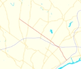
Pennsylvania Route 132 (PA 132) is a state highway
in southeast Pennsylvania
. It runs northwest to southeast through Bucks County in suburban Philadelphia from PA 611
in Warrington Township
to Interstate 95
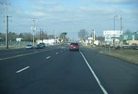
(I-95) in Bensalem Township
. It is a commercial route lined with shopping centers throughout much of its 15 miles (24 km) length. It is named Street Road and is five lanes wide for much of its length. It was also designated as the Armed Forces and Veterans Memorial Highway in 2005. From west to east, it crosses PA 263
and PA 332
in Warminster Township
, PA 232
in Upper Southampton Township
, PA 532
in Lower Southampton Township
, and U.S. Route 1
(US 1), PA 513
, and US 13
in Bensalem Township. Street Road was included in William Penn
's survey plans and completed by 1737. The road was paved by 1911 and received the PA 132 designation by 1930. The road was widened into a divided highway
and extended to I-95 by 1970. An E-ZPass
-only interchange with the Pennsylvania Turnpike
(I-276) opened in 2010.
 PA 132 begins at an intersection with PA 611
(Easton Road) in Warrington Township
, heading to the southeast on West Street Road, a four-lane road that alternates between a divided highway
and an undivided five-lane road including a center left-turn lane. West of PA 611, Street Road continues as an unnumbered road to Lower State Road. It heads through commercial areas before crossing the Little Neshaminy Creek and entering residential areas. At the Valley Road intersection, the route crosses into Warminster Township
and continues through suburban development. PA 132 enters commercial areas as it comes to an intersection with PA 263
(York Road). After crossing the New Hope and Ivyland Railroad
at-grade about 300 feet (91.4 m) north of that railroad meeting SEPTA's Warminster Line
, the route passes through industrial areas before intersecting PA 332
(Jacksonville Road).
Past the PA 332 intersection, the road continues through a mix of homes and businesses as East Street Road. Upon crossing Davisville Road, PA 132 enters Upper Southampton Township
and passes more businesses. The road crosses PA 232
(Second Street Pike) in the community of Southampton
before crossing a bridge over SEPTA's abandoned Fox Chase/Newtown Line. After passing through wooded residential areas, the road crosses into Lower Southampton Township
at the Stump Road intersection and passes under Norfolk Southern's Morrisville Line.
Street Road continues past a mix of residential and commercial development as it comes to an intersection with PA 532
(Bustleton Pike) in the community of Feasterville
. After crossing PA 532, the road heads past several businesses before turning south-southeast into woodland. PA 132 turns southeast again and intersects Philmont Avenue prior to entering Bensalem Township
. Upon entering Bensalem, the route passes over SEPTA's West Trenton Line
on a bridge as it enters commercial areas again. After a bridge over CSX's Trenton Subdivision
, PA 132 passes under the Pennsylvania Turnpike
(I-276) immediately before an intersection with Old Lincoln Highway, becoming a divided highway.
A short distance later, the road reaches a partial cloverleaf interchange
with US 1
before turning south and coming to an E-ZPass
-only ramp that provides access to and from the eastbound Pennsylvania Turnpike. PA 132 continues south-southeast past more businesses, becoming an undivided road again and passing the entrance to the Philadelphia Park Racetrack
and Parx Casino. The road passes more development as it reaches the PA 513
(Hulmeville Road) intersection. Farther southeast, PA 132 reaches an interchange with US 13
before ending at the I-95
interchange. Past I-95, Street Road continues as an unnumbered road to State Road.
for the Province of Pennsylvania
. The entire length of the road was completed by 1737. Street Road became a paved road by 1911; at the time, the route was not defined as a legislative route. By 1930, PA 132 was designated onto Street Road, running from US 611 (now PA 611) in Warrington Township southeast to US 13 in Bensalem Township. The entire length of PA 132 was widened into a divided highway by 1970. As a result of this improvement, a portion of the road was relocated east of Feasterville, with the former alignment becoming Old Street Road. Also by this time, the route was extended southeast to an interchange with I-95. In 2005, all of PA 132 was designated the Armed Forces and Veterans Memorial Highway. On November 22, 2010, an E-ZPass
only ramp with access to and from the eastbound Pennsylvania Turnpike in Bensalem Township opened, intended to provide improved access to the Parx Casino and reduce congestion at the Pennsylvania Turnpike interchange with US 1.
State highway
State highway, state road or state route can refer to one of three related concepts, two of them related to a state or provincial government in a country that is divided into states or provinces :#A...
in southeast Pennsylvania
Pennsylvania
The Commonwealth of Pennsylvania is a U.S. state that is located in the Northeastern and Mid-Atlantic regions of the United States. The state borders Delaware and Maryland to the south, West Virginia to the southwest, Ohio to the west, New York and Ontario, Canada, to the north, and New Jersey to...
. It runs northwest to southeast through Bucks County in suburban Philadelphia from PA 611
Pennsylvania Route 611
Pennsylvania Route 611 is a major state highway in Pennsylvania, United States, running from Interstate 95 south of downtown Philadelphia north to Interstate 380 in Coolbaugh Township, Pennsylvania in The Poconos....
in Warrington Township
Warrington Township, Bucks County, Pennsylvania
Warrington Township is a township in Bucks County, Pennsylvania, United States. The population was 23,418 at the 2010 census.-History:Warrington Township was founded in October 1734, and is named after a town in Lancashire, England...
to Interstate 95
Interstate 95 in Pennsylvania
Interstate 95 is an Interstate highway running from Miami, Florida north to Houlton, Maine. In the U.S. state of Pennsylvania, the route is known by many as the Delaware Expressway, but is officially named The Vietnam Veterans Memorial Highway. and locally known as "95"...
(I-95) in Bensalem Township
Bensalem Township, Pennsylvania
Bensalem Township is a township in Bucks County, Pennsylvania, United States which borders the northeast section of Philadelphia. The township is composed of many communities, including Bensalem, Trevose, Oakford, Cornwells Heights, Eddington, and Andalusia...
. It is a commercial route lined with shopping centers throughout much of its 15 miles (24 km) length. It is named Street Road and is five lanes wide for much of its length. It was also designated as the Armed Forces and Veterans Memorial Highway in 2005. From west to east, it crosses PA 263
Pennsylvania Route 263
Pennsylvania Route 263 is a north–south state highway located in southeast Pennsylvania. The southern terminus of the route is at PA 611 in Willow Grove, Montgomery County. The northern terminus is at PA 32 in Centre Bridge, Bucks County on the banks of the Delaware River near the Centre...
and PA 332
Pennsylvania Route 332
Pennsylvania Route 332 is a state highway in the U.S. state of Pennsylvania. The route runs from Pennsylvania Route 263 in Hatboro, Montgomery County east to Pennsylvania Route 32 in Yardley, Bucks County.-Route description:...
in Warminster Township
Warminster Township, Pennsylvania
Warminster Township is a township in Bucks County, Pennsylvania, United States. The population was 32,682 at the 2010 census.The town was named for the town of Warminster in Wiltshire, England.-Geography:...
, PA 232
Pennsylvania Route 232
Pennsylvania Route 232 is a long state highway located in southeastern Pennsylvania. The southern terminus of the route is at U.S. Route 1 and US 13 at the Oxford Circle in Philadelphia. The northern terminus is at PA 32 in the borough of New Hope, Bucks County, on the banks of the Delaware River...
in Upper Southampton Township
Upper Southampton Township, Pennsylvania
Upper Southampton Township is a township in Bucks County, Pennsylvania, United States. The population was 15,152 at the 2010 census.-Geography:...
, PA 532
Pennsylvania Route 532
Pennsylvania Route 532 is a state route located in the Philadelphia, Pennsylvania area.-Philadelphia:PA 532 begins as Welsh Road, where it intersects with Roosevelt Boulevard in Northeast Philadelphia. After less than a mile, PA 532 leaves Welsh Road and follows Bustleton Avenue...
in Lower Southampton Township
Lower Southampton Township, Pennsylvania
Lower Southampton Township is a township in Bucks County, Pennsylvania, United States. The population was 18,909 at the 2010 census.-Geography:...
, and U.S. Route 1
U.S. Route 1 in Pennsylvania
U.S. Route 1 is a major north–south U.S. Highway, extending from the Florida Keys in the south to the Canadian border in the north. In the U.S. state of Pennsylvania, US 1 runs for from the Maryland state line near Oxford to the New Jersey state line near Trenton.-Maryland to Interstate...
(US 1), PA 513
Pennsylvania Route 513
Pennsylvania Route 513 is a state highway in Bucks County, Pennsylvania. The route runs from U.S. Route 13 in Bensalem Township north to U.S. Route 1 Business and Pennsylvania Route 413 in Penndel.-Route description:...
, and US 13
U.S. Route 13
U.S. Route 13 is a north–south U.S. highway established in 1926 that runs for from Interstate 95 just north of Fayetteville, North Carolina to the northeastern suburbs of Philadelphia, Pennsylvania, in Morrisville. In all, it traverses five states in the Atlantic coastal plain region,...
in Bensalem Township. Street Road was included in William Penn
William Penn
William Penn was an English real estate entrepreneur, philosopher, and founder of the Province of Pennsylvania, the English North American colony and the future Commonwealth of Pennsylvania. He was an early champion of democracy and religious freedom, notable for his good relations and successful...
's survey plans and completed by 1737. The road was paved by 1911 and received the PA 132 designation by 1930. The road was widened into a divided highway
Divided Highway
Divided Highway is a compilation album by American rock band The Doobie Brothers, released in 2003. . All tracks are taken from the albums Cycles and Brotherhood .-Track listing:...
and extended to I-95 by 1970. An E-ZPass
E-ZPass
E-ZPass is an electronic toll-collection system used on most tolled roads, bridges, and tunnels in the northeastern US, south to Virginia and West Virginia, and west to Illinois. Currently, there are 25 agencies spread across 14 states that make up the . All member agencies use the same technology,...
-only interchange with the Pennsylvania Turnpike
Pennsylvania Turnpike
The Pennsylvania Turnpike is a toll highway system operated by the Pennsylvania Turnpike Commission in the Commonwealth of Pennsylvania, United States. The three sections of the turnpike system total . The main section extends from Ohio to New Jersey and is long...
(I-276) opened in 2010.
Route description
Pennsylvania Route 611
Pennsylvania Route 611 is a major state highway in Pennsylvania, United States, running from Interstate 95 south of downtown Philadelphia north to Interstate 380 in Coolbaugh Township, Pennsylvania in The Poconos....
(Easton Road) in Warrington Township
Warrington Township, Bucks County, Pennsylvania
Warrington Township is a township in Bucks County, Pennsylvania, United States. The population was 23,418 at the 2010 census.-History:Warrington Township was founded in October 1734, and is named after a town in Lancashire, England...
, heading to the southeast on West Street Road, a four-lane road that alternates between a divided highway
Divided Highway
Divided Highway is a compilation album by American rock band The Doobie Brothers, released in 2003. . All tracks are taken from the albums Cycles and Brotherhood .-Track listing:...
and an undivided five-lane road including a center left-turn lane. West of PA 611, Street Road continues as an unnumbered road to Lower State Road. It heads through commercial areas before crossing the Little Neshaminy Creek and entering residential areas. At the Valley Road intersection, the route crosses into Warminster Township
Warminster Township, Pennsylvania
Warminster Township is a township in Bucks County, Pennsylvania, United States. The population was 32,682 at the 2010 census.The town was named for the town of Warminster in Wiltshire, England.-Geography:...
and continues through suburban development. PA 132 enters commercial areas as it comes to an intersection with PA 263
Pennsylvania Route 263
Pennsylvania Route 263 is a north–south state highway located in southeast Pennsylvania. The southern terminus of the route is at PA 611 in Willow Grove, Montgomery County. The northern terminus is at PA 32 in Centre Bridge, Bucks County on the banks of the Delaware River near the Centre...
(York Road). After crossing the New Hope and Ivyland Railroad
New Hope and Ivyland Railroad
The New Hope and Ivyland Railroad is a shortline railroad in Pennsylvania. It also operates a heritage railroad, offering passenger excursions....
at-grade about 300 feet (91.4 m) north of that railroad meeting SEPTA's Warminster Line
Warminster Line
The Warminster Line is a route of the SEPTA Regional Rail commuter rail. It serves stations between its namesake town, Warminster, and Center City, Philadelphia...
, the route passes through industrial areas before intersecting PA 332
Pennsylvania Route 332
Pennsylvania Route 332 is a state highway in the U.S. state of Pennsylvania. The route runs from Pennsylvania Route 263 in Hatboro, Montgomery County east to Pennsylvania Route 32 in Yardley, Bucks County.-Route description:...
(Jacksonville Road).
Past the PA 332 intersection, the road continues through a mix of homes and businesses as East Street Road. Upon crossing Davisville Road, PA 132 enters Upper Southampton Township
Upper Southampton Township, Pennsylvania
Upper Southampton Township is a township in Bucks County, Pennsylvania, United States. The population was 15,152 at the 2010 census.-Geography:...
and passes more businesses. The road crosses PA 232
Pennsylvania Route 232
Pennsylvania Route 232 is a long state highway located in southeastern Pennsylvania. The southern terminus of the route is at U.S. Route 1 and US 13 at the Oxford Circle in Philadelphia. The northern terminus is at PA 32 in the borough of New Hope, Bucks County, on the banks of the Delaware River...
(Second Street Pike) in the community of Southampton
Southampton, Pennsylvania
Southampton, Pennsylvania is an unincorporated community in the U.S. state of Pennsylvania, situated in the South-Eastern tip of Bucks County.Southampton is located 18 miles North, from the center of Philadelphia....
before crossing a bridge over SEPTA's abandoned Fox Chase/Newtown Line. After passing through wooded residential areas, the road crosses into Lower Southampton Township
Lower Southampton Township, Pennsylvania
Lower Southampton Township is a township in Bucks County, Pennsylvania, United States. The population was 18,909 at the 2010 census.-Geography:...
at the Stump Road intersection and passes under Norfolk Southern's Morrisville Line.
Street Road continues past a mix of residential and commercial development as it comes to an intersection with PA 532
Pennsylvania Route 532
Pennsylvania Route 532 is a state route located in the Philadelphia, Pennsylvania area.-Philadelphia:PA 532 begins as Welsh Road, where it intersects with Roosevelt Boulevard in Northeast Philadelphia. After less than a mile, PA 532 leaves Welsh Road and follows Bustleton Avenue...
(Bustleton Pike) in the community of Feasterville
Feasterville-Trevose, Pennsylvania
Feasterville-Trevose is a former census-designated place in Lower Southampton Township in Bucks County, Pennsylvania. The population was 6,525 at the 2000 census. The ZIP code is 19053. The area has been separated into two CDPs in the 2010 census....
. After crossing PA 532, the road heads past several businesses before turning south-southeast into woodland. PA 132 turns southeast again and intersects Philmont Avenue prior to entering Bensalem Township
Bensalem Township, Pennsylvania
Bensalem Township is a township in Bucks County, Pennsylvania, United States which borders the northeast section of Philadelphia. The township is composed of many communities, including Bensalem, Trevose, Oakford, Cornwells Heights, Eddington, and Andalusia...
. Upon entering Bensalem, the route passes over SEPTA's West Trenton Line
West Trenton Line (SEPTA)
The West Trenton Line is a SEPTA Regional Rail line connecting Center City Philadelphia to West Trenton, New Jersey.-Route:The West Trenton Line connects Center City, Philadelphia with the West Trenton section of Ewing, New Jersey...
on a bridge as it enters commercial areas again. After a bridge over CSX's Trenton Subdivision
Trenton Subdivision
The Trenton Subdivision is a railroad line owned by CSX Transportation in the U.S. states of Pennsylvania and New Jersey. The line runs from Park Junction in Philadelphia, Pennsylvania northeast to Manville, New Jersey along a former Reading Company line....
, PA 132 passes under the Pennsylvania Turnpike
Pennsylvania Turnpike
The Pennsylvania Turnpike is a toll highway system operated by the Pennsylvania Turnpike Commission in the Commonwealth of Pennsylvania, United States. The three sections of the turnpike system total . The main section extends from Ohio to New Jersey and is long...
(I-276) immediately before an intersection with Old Lincoln Highway, becoming a divided highway.
A short distance later, the road reaches a partial cloverleaf interchange
Cloverleaf interchange
A cloverleaf interchange is a two-level interchange in which left turns, reverse direction in left-driving regions, are handled by ramp roads...
with US 1
U.S. Route 1 in Pennsylvania
U.S. Route 1 is a major north–south U.S. Highway, extending from the Florida Keys in the south to the Canadian border in the north. In the U.S. state of Pennsylvania, US 1 runs for from the Maryland state line near Oxford to the New Jersey state line near Trenton.-Maryland to Interstate...
before turning south and coming to an E-ZPass
E-ZPass
E-ZPass is an electronic toll-collection system used on most tolled roads, bridges, and tunnels in the northeastern US, south to Virginia and West Virginia, and west to Illinois. Currently, there are 25 agencies spread across 14 states that make up the . All member agencies use the same technology,...
-only ramp that provides access to and from the eastbound Pennsylvania Turnpike. PA 132 continues south-southeast past more businesses, becoming an undivided road again and passing the entrance to the Philadelphia Park Racetrack
Philadelphia Park Racetrack
Parx Racing and Casino is a thoroughbred horse racetrack and racino in Bensalem, Pennsylvania. It currently houses 3,300 slot machines.-History:...
and Parx Casino. The road passes more development as it reaches the PA 513
Pennsylvania Route 513
Pennsylvania Route 513 is a state highway in Bucks County, Pennsylvania. The route runs from U.S. Route 13 in Bensalem Township north to U.S. Route 1 Business and Pennsylvania Route 413 in Penndel.-Route description:...
(Hulmeville Road) intersection. Farther southeast, PA 132 reaches an interchange with US 13
U.S. Route 13 in Pennsylvania
U.S. Route 13 passes through the Philadelphia metropolitan area in the U.S. state of Pennsylvania. The route enters the state from Delaware in Marcus Hook, Delaware County. It continues in a northeasterly direction through Delaware County, passes through Philadelphia, and continues into Bucks...
before ending at the I-95
Interstate 95 in Pennsylvania
Interstate 95 is an Interstate highway running from Miami, Florida north to Houlton, Maine. In the U.S. state of Pennsylvania, the route is known by many as the Delaware Expressway, but is officially named The Vietnam Veterans Memorial Highway. and locally known as "95"...
interchange. Past I-95, Street Road continues as an unnumbered road to State Road.
History
Street Road was originally surveyed in the late 17th century, with the road being included in the original survey plans of William PennWilliam Penn
William Penn was an English real estate entrepreneur, philosopher, and founder of the Province of Pennsylvania, the English North American colony and the future Commonwealth of Pennsylvania. He was an early champion of democracy and religious freedom, notable for his good relations and successful...
for the Province of Pennsylvania
Province of Pennsylvania
The Province of Pennsylvania, also known as Pennsylvania Colony, was founded in British America by William Penn on March 4, 1681 as dictated in a royal charter granted by King Charles II...
. The entire length of the road was completed by 1737. Street Road became a paved road by 1911; at the time, the route was not defined as a legislative route. By 1930, PA 132 was designated onto Street Road, running from US 611 (now PA 611) in Warrington Township southeast to US 13 in Bensalem Township. The entire length of PA 132 was widened into a divided highway by 1970. As a result of this improvement, a portion of the road was relocated east of Feasterville, with the former alignment becoming Old Street Road. Also by this time, the route was extended southeast to an interchange with I-95. In 2005, all of PA 132 was designated the Armed Forces and Veterans Memorial Highway. On November 22, 2010, an E-ZPass
E-ZPass
E-ZPass is an electronic toll-collection system used on most tolled roads, bridges, and tunnels in the northeastern US, south to Virginia and West Virginia, and west to Illinois. Currently, there are 25 agencies spread across 14 states that make up the . All member agencies use the same technology,...
only ramp with access to and from the eastbound Pennsylvania Turnpike in Bensalem Township opened, intended to provide improved access to the Parx Casino and reduce congestion at the Pennsylvania Turnpike interchange with US 1.