

U.S. Route 13 in Pennsylvania
Encyclopedia
U.S. Route 13 passes through the Philadelphia metropolitan area
in the U.S. state
of Pennsylvania
. The route enters the state from Delaware
in Marcus Hook
, Delaware County
. It continues in a northeasterly direction through Delaware County, passes through Philadelphia, and continues into Bucks County
, where it ends at U.S. 1
in Falls Township
, west of the borough of Morrisville
.Throughout most of its route in Pennsylvania, U.S. Route 13 runs within a close distance of Interstate 95
.
oil refinery and then the town itself, where it meets the southern terminus of Pennsylvania Route 452
. The road then enters the borough of Trainer
, where it passes by a ConocoPhillips
refinery. It is also where U.S. Route 13 intersects the western terminus of Pennsylvania Route 291
, which runs a short distance from the Delaware River
in Delaware County destined for Philadelphia International Airport
.
U.S. Route 13 then enters the city of Chester
, where the name changes to Fourth Street. It follows Fourth Street east for a short distance before turning north on Highland Avenue and then east on Ninth Street. Ninth Street carries U.S. Route 13 through the majority of Chester. It features an interchange with the U.S. Route 322
approach to the Commodore Barry Bridge
and then continues into Downtown Chester, where it intersects the southern terminus of Pennsylvania Route 352
and Pennsylvania Route 320
(Avenue of the States). U.S. Route 13 then continues in an easterly direction and exits Chester on Morton Avenue.
It then leaves Chester and the road name changes to Chester Pike. US 13 forms the northern border of the borough of Eddystone
and then enters Ridley Township
. U.S. Route 13 passes under I-95 and continues into the borough of Ridley Park
. It intersects Stewart Avenue, which heads south to provide access to I-95 and PA 291. U.S. Route 13 continues into Prospect Park
, where it crosses Pennsylvania Route 420
. It heads eastward, passing through the boroughs of Norwood
, Glenolden
, Folcroft
, and Sharon Hill
. It then enters the borough of Collingdale
, where it merges onto Macdade Boulevard.
Macdade Boulevard carries U.S. Route 13 through the borough of Darby
and into the borough of Yeadon
. In Yeadon, U.S. Route 13 turns north onto Church Lane. It follows Church Lane to Baltimore Aveue
, where it turns east onto Baltimore Avenue and continues into the city of Philadelphia.
 U.S. Route 13 enters the West Philadelphia
section of the city on Baltimore Avenue. Along the way, SEPTA Route 34
of the Subway–Surface Trolley Lines runs on US 13 from the Angora Loop at 61st Street to the 40th Street Portal. The route continues east through West Philadelphia towards University City
. It then turns north from Baltimore Avenue on 38th Street near the University of Pennsylvania
campus. U.S. Route 13 crosses Pennsylvania Route 3
, which intersects US 13 along a one-way pair
, with the westbound routing following US 13 southbound between Market Street
and Walnut Street
and the eastbound routing crossing US 13 on Chestnut Street
.
U.S. Route 13 turns east onto two-way Powelton Avenue. Powelton Avenue carries U.S. Route 13 across Lancaster Avenue into the Mantua
section of the city. Here, U.S. Route 13 splits onto 33rd Street northbound and 34th Street southbound. It follows this one-way pair up to the crossing of the Northeast Corridor
, where it heads two-way on 34th Street. 34th Street runs between the Philadelphia Zoo
to the west and the Schuylkill Expressway (Interstate 76
) to the east.
U.S. Route 13 then meets Girard Avenue
, which at this point carries U.S. Route 30
. It turns east onto Girard Avenue, where U.S. Route 30 turns east onto the Schuylkill Expressway. U.S. Route 13 crosses the Schuylkill Expressway and then the Schuylkill River
.
Across the Schuylkill River, U.S. Route 13 turns north on 33rd Street. It forms the eastern boundary of Fairmount Park
and then merges onto Ridge Avenue. It then heads northeast onto Hunting Park Avenue into the North Philadelphia
section of the city. Hunting Park Avenue splits to the east and U.S. Route 13 becomes Roosevelt Boulevard
, crossing Broad Street
(Pennsylvania Route 611
). It then merges onto .S. Route 1 in Pennsylvania|U.S. 1], continuing along Roosevelt Boulevard.
 U.S. Route 13, along with US 1, continues east on the wide, multi-lane Roosevelt Boulevard into Northeast Philadelphia
. It passes underneath the Oxford Circle
, a traffic circle
where Oxford Avenue, Cheltenham Avenue, and Castor Avenue meet. This circle marks the southern terminus of Pennsylvania Route 232
, which heads north on Oxford Avenue. U.S. Route 13 splits from the Roosevelt Boulevard by heading southeast on the one-way pair of Robbins Street northbound and Levick Street southbound. It follows this one-way pair to Frankford Avenue, which it turns onto, heading northeast. Robbins and Levick Streets continue southeast toward the Tacony-Palmyra Bridge
.
Frankford Avenue carries U.S. Route 13 northeastward. It intersects Cottman Avenue (Pennsylvania Route 73
) and then crosses the Pennypack Creek
. Frankford Avenue then intersects Academy Road before crossing the Poquessing Creek
into Bucks County.
in Bucks County, where the name becomes Bristol Pike. It features an interchange with Pennsylvania Route 63
(Woodhaven Road) a short distance north of I-95. U.S. Route 13 then intersects the southern terminus of Pennsylvania Route 513
before featuring another interchange with Pennsylvania Route 132
(Street Road). It then crosses under I-95 and then over the Neshaminy Creek
into Bristol Township
.
In Bristol Township, U.S. Route 13 heads in an easterly direction, following the Northeast Corridor rail line to the north. It then crosses Pennsylvania Route 413
a short distance north of the Burlington-Bristol Bridge
. U.S. Route 13 then skirts the northern edge of the borough of Bristol
before featuring an interchange with the Pennsylvania Turnpike
(Interstate 276), the easternmost interchange on the mainline turnpike before the Delaware River-Turnpike Toll Bridge
.
U.S. Route 13 continues north to the borough of Tullytown
. It then enters Falls Township, where it transforms into a limited-access highway, running along the eastern border of the planned suburb of Levittown
. It features diamond interchanges with the Mill Creek Parkway and Penn Valley Road. It then features a cloverleaf interchange with Tyburn Road. U.S. Route 13 then intersects Lower Morrisville Road before ending at an interchange with U.S. Route 1. The expressway ends here, and the road continues north as an unnumbered surface road called Pine Grove Road, which heads into Lower Makefield Township
.
from Philadelphia to Morrisville. In 1954, construction began on the limited-access portion of US 13 in Bucks County with the section from U.S. Route 1 to Tyburn Road opening in 1955 and the section from Tyburn Road to Tullytown opening in 1956. U.S. Route 13 was moved to this expressway from its former alignment which followed Bristol Pike between Tullytown and Morrisville.
At the time of its completion, this expressway was planned to be a part of Interstate 95
, with the highway leaving its current alignment at Exit 40 (Pennsylvania Route 413
) and following US 13 up to US 1, where it would head north into Trenton
by way of the Trenton-Morrisville Toll Bridge
. However, New Jersey officials opposed this plan, and I-95 was routed to cross the Delaware River on the Scudders Falls Bridge. In 1969, another plan was created to build a US 13 expressway that would provide a direct connection between I-95 and the Pennsylvania Turnpike
(Interstate 276). It would have run from Exit 40 of I-95, intersect the PA Turnpike, and head to the southern end of the completed US 13 expressway in Tullytown. It was eventually cancelled due to feared environmental impacts on Silver Lake Park.
Delaware Valley
The Delaware Valley is a term used to refer to the valley where the Delaware River flows, along with the surrounding communities. This includes the metropolitan area centered on the city of Philadelphia. Such educational institutions as Delaware Valley Regional High School in Alexandria Township...
in the U.S. state
U.S. state
A U.S. state is any one of the 50 federated states of the United States of America that share sovereignty with the federal government. Because of this shared sovereignty, an American is a citizen both of the federal entity and of his or her state of domicile. Four states use the official title of...
of Pennsylvania
Pennsylvania
The Commonwealth of Pennsylvania is a U.S. state that is located in the Northeastern and Mid-Atlantic regions of the United States. The state borders Delaware and Maryland to the south, West Virginia to the southwest, Ohio to the west, New York and Ontario, Canada, to the north, and New Jersey to...
. The route enters the state from Delaware
Delaware
Delaware is a U.S. state located on the Atlantic Coast in the Mid-Atlantic region of the United States. It is bordered to the south and west by Maryland, and to the north by Pennsylvania...
in Marcus Hook
Marcus Hook, Pennsylvania
Marcus Hook is a borough in Delaware County, Pennsylvania, United States. The population peaked in the 1920s with 5,324 inhabitants. 2,314 inhabitants were counted at the recent 2000 census. Marcus Hook's current mayor is James Schiliro. The borough calls itself "The Cornerstone of Pennsylvania"....
, Delaware County
Delaware County, Pennsylvania
Delaware County is a county located in the U.S. state of Pennsylvania. As of 2010, the population was 558,979, making it Pennsylvania's fifth most populous county, behind Philadelphia, Allegheny, Montgomery, and Bucks counties....
. It continues in a northeasterly direction through Delaware County, passes through Philadelphia, and continues into Bucks County
Bucks County, Pennsylvania
- Industry and commerce :The boroughs of Bristol and Morrisville were prominent industrial centers along the Northeast Corridor during World War II. Suburban development accelerated in Lower Bucks in the 1950s with the opening of Levittown, Pennsylvania, the second such "Levittown" designed by...
, where it ends at U.S. 1
U.S. Route 1 in Pennsylvania
U.S. Route 1 is a major north–south U.S. Highway, extending from the Florida Keys in the south to the Canadian border in the north. In the U.S. state of Pennsylvania, US 1 runs for from the Maryland state line near Oxford to the New Jersey state line near Trenton.-Maryland to Interstate...
in Falls Township
Falls Township, Bucks County, Pennsylvania
Falls Township is a township in Bucks County, Pennsylvania, United States. The population was 34,300 at the 2010 census. Portions of Fairless Hills and Levittown, Pennsylvania, are located in the township...
, west of the borough of Morrisville
Morrisville, Bucks County, Pennsylvania
Morrisville is a borough in Bucks County, Pennsylvania, United States. The population was 8,728 at the 2010 census.-Geography:Morrisville is located at . It is situated on the Delaware River directly across from Trenton, New Jersey...
.Throughout most of its route in Pennsylvania, U.S. Route 13 runs within a close distance of Interstate 95
Interstate 95 in Pennsylvania
Interstate 95 is an Interstate highway running from Miami, Florida north to Houlton, Maine. In the U.S. state of Pennsylvania, the route is known by many as the Delaware Expressway, but is officially named The Vietnam Veterans Memorial Highway. and locally known as "95"...
.
Delaware County
U.S. Route 13 crosses into Pennsylvania from Delaware in the borough of Marcus Hook, where the road is known as Post Road. It passes through a huge SunocoSunoco
Sunoco Inc. is an American petroleum and petrochemical manufacturer headquartered in Philadelphia, Pennsylvania, United States, formerly known as Sun Company Inc. and Sun Oil Co. ....
oil refinery and then the town itself, where it meets the southern terminus of Pennsylvania Route 452
Pennsylvania Route 452
Pennsylvania Route 452 is a state highway in Delaware County, Pennsylvania. The route runs from U.S. Route 13 in Marcus Hook north to Pennsylvania Route 352 in Lima.-Route description:...
. The road then enters the borough of Trainer
Trainer, Pennsylvania
Trainer is a borough in Delaware County, Pennsylvania, United States. The population was 1,901 at the 2000 census. The borough was named after David Trainer, a local mill owner.-Geography:Trainer is located at ....
, where it passes by a ConocoPhillips
ConocoPhillips
ConocoPhillips Company is an American multinational energy corporation with its headquarters located in the Energy Corridor district of Houston, Texas in the United States...
refinery. It is also where U.S. Route 13 intersects the western terminus of Pennsylvania Route 291
Pennsylvania Route 291
Pennsylvania Route 291 is an east–west route that connects U.S. Route 13 in the Trainer/Marcus Hook area to Interstate 76 in Southwest Philadelphia near the Walt Whitman Bridge and the South Philadelphia Sports Complex. Except for a short section between U.S. Route 13 and the...
, which runs a short distance from the Delaware River
Delaware River
The Delaware River is a major river on the Atlantic coast of the United States.A Dutch expedition led by Henry Hudson in 1609 first mapped the river. The river was christened the South River in the New Netherland colony that followed, in contrast to the North River, as the Hudson River was then...
in Delaware County destined for Philadelphia International Airport
Philadelphia International Airport
Philadelphia International Airport is a major airport in Philadelphia, Pennsylvania, United States, and is the largest airport in the Delaware Valley region and in Pennsylvania...
.
U.S. Route 13 then enters the city of Chester
Chester, Pennsylvania
Chester is a city in Delaware County, Pennsylvania, United States, with a population of 33,972 at the 2010 census. Chester is situated on the Delaware River, between the cities of Philadelphia and Wilmington, Delaware.- History :...
, where the name changes to Fourth Street. It follows Fourth Street east for a short distance before turning north on Highland Avenue and then east on Ninth Street. Ninth Street carries U.S. Route 13 through the majority of Chester. It features an interchange with the U.S. Route 322
U.S. Route 322
U.S. Route 322 is a long, east–west United States Highway, traversing Ohio, Pennsylvania, and New Jersey. The road is a spur of U.S. Route 22 and one of the original highways from 1926...
approach to the Commodore Barry Bridge
Commodore Barry Bridge
The Commodore Barry Bridge is a cantilever bridge that spans the Delaware River from Chester, Pennsylvania to Bridgeport, in Logan Township, New Jersey, USA...
and then continues into Downtown Chester, where it intersects the southern terminus of Pennsylvania Route 352
Pennsylvania Route 352
Pennsylvania Route 352 is a north–south route that begins at U.S. Route 13 in Chester and ends at U.S. Route 30 in Malvern. It is known as Middletown Road between Pennsylvania Route 452 and Pennsylvania Route 926, with the route north of Route 926 called Chester Road.- Delaware County :A few...
and Pennsylvania Route 320
Pennsylvania Route 320
Pennsylvania Route 320 is a north–south state highway in southeastern Pennsylvania. The southern terminus of the long route is at PA 291 in Chester...
(Avenue of the States). U.S. Route 13 then continues in an easterly direction and exits Chester on Morton Avenue.
It then leaves Chester and the road name changes to Chester Pike. US 13 forms the northern border of the borough of Eddystone
Eddystone, Pennsylvania
Eddystone is a borough in Delaware County, Pennsylvania, United States. The population was 2,442 at the 2000 census.-Early history:The area at the mouth of Ridley Creek was first called "Tequirassy" by Native Americans. The land was owned by Olof Persson Stille, one of the early settlers from New...
and then enters Ridley Township
Ridley Township, Pennsylvania
Ridley Township is a township in Delaware County, Pennsylvania, United States. The population was 30,791 at the 2000 census.Students residing within the district generally attend schools within the Ridley School District, although there are several Catholic schools located in the township as...
. U.S. Route 13 passes under I-95 and continues into the borough of Ridley Park
Ridley Park, Pennsylvania
Ridley Park is a borough in Delaware County, Pennsylvania, United States. The population was 7,196 at the 2000 census. Ridley Park is the home of Boeing Helicopters.-Native American:...
. It intersects Stewart Avenue, which heads south to provide access to I-95 and PA 291. U.S. Route 13 continues into Prospect Park
Prospect Park, Pennsylvania
Prospect Park is a borough in Delaware County, Pennsylvania, United States. The population was 6,594 at the 2000 census. It originated as a bedroom community of Philadelphia...
, where it crosses Pennsylvania Route 420
Pennsylvania Route 420
Pennsylvania Route 420 is a short, north–south state highway in Delaware County, Pennsylvania. The route runs from Pennsylvania Route 291 in Tinicum Township, a short distance west of the Philadelphia International Airport, to Pennsylvania Route 320 in Springfield Township.-Route...
. It heads eastward, passing through the boroughs of Norwood
Norwood, Pennsylvania
Norwood is a borough in Delaware County, Pennsylvania, United States. The population was 5,985 at the 2000 census.-Geography:Norwood is located at ....
, Glenolden
Glenolden, Pennsylvania
Glenolden is a borough in Delaware County, Pennsylvania, United States. The population was 7,476 at the 2000 census.-Geography:Glenolden is located at ....
, Folcroft
Folcroft, Pennsylvania
Folcroft is a borough in Delaware County, Pennsylvania, United States. The population was 6,978 at the 2000 census.-Geography:Folcroft is located at ....
, and Sharon Hill
Sharon Hill, Pennsylvania
Sharon Hill is a borough in Delaware County, Pennsylvania, United States. The population was 5,468 at the 2000 census.-Geography:Sharon Hill is located at ....
. It then enters the borough of Collingdale
Collingdale, Pennsylvania
Collingdale is a borough in Delaware County, Pennsylvania, United States. The population was 8,664, at the 2000 census, 502 above the 1940 count of 8,162.-Geography:Collingdale is located at ....
, where it merges onto Macdade Boulevard.
Macdade Boulevard carries U.S. Route 13 through the borough of Darby
Darby, Pennsylvania
Darby is a borough in Delaware County, Pennsylvania, United States, along Darby Creek southwest of downtown Philadelphia. It has a public library founded in 1743 and a cemetery more than 300 years old. The Quakers lived there early in the colonial era. Darby was settled about 1660 and was...
and into the borough of Yeadon
Yeadon, Pennsylvania
Yeadon is a borough in Delaware County, Pennsylvania, United States. It borders the City of Philadelphia. The population was 11,762 at the 2000 census.-Geography:Yeadon is located at ....
. In Yeadon, U.S. Route 13 turns north onto Church Lane. It follows Church Lane to Baltimore Aveue
Baltimore Pike
thumb|[[SEPTA]]'s [[SEPTA Route 34|Route 34]] streetcar line runs through the 4500 block of Baltimore Avenue in [[West Philadelphia]]The Baltimore Pike was an auto trail in the United States, connecting Baltimore, Maryland with Philadelphia, Pennsylvania....
, where it turns east onto Baltimore Avenue and continues into the city of Philadelphia.
Philadelphia
West Philadelphia
West Philadelphia, nicknamed West Philly, is a section of Philadelphia, Pennsylvania. Though there is no official definition of its boundaries, it is generally considered to reach from the western shore of the Schuylkill River, to City Line Avenue to the northwest, Cobbs Creek to the southwest, and...
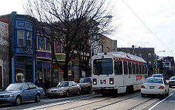
section of the city on Baltimore Avenue. Along the way, SEPTA Route 34
SEPTA Route 34
SEPTA's Subway-Surface Trolley Route 34, also called the Baltimore Avenue-Subway Line, is a trolley line operated by the Southeastern Pennsylvania Transportation Authority that connects the 13th Street in downtown Philadelphia, Pennsylvania, to the Angora Loop station in the Angora neighborhood of...
of the Subway–Surface Trolley Lines runs on US 13 from the Angora Loop at 61st Street to the 40th Street Portal. The route continues east through West Philadelphia towards University City
University City, Philadelphia, Pennsylvania
University City is the easternmost region of West Philadelphia.The University of Pennsylvania has long been the dominant institution in the area and was instrumental in coining the name University City as part of a 1950s urban-renewal effort...
. It then turns north from Baltimore Avenue on 38th Street near the University of Pennsylvania
University of Pennsylvania
The University of Pennsylvania is a private, Ivy League university located in Philadelphia, Pennsylvania, United States. Penn is the fourth-oldest institution of higher education in the United States,Penn is the fourth-oldest using the founding dates claimed by each institution...
campus. U.S. Route 13 crosses Pennsylvania Route 3
Pennsylvania Route 3
Pennsylvania Route 3 is a state highway located in the southeastern portion of Pennsylvania. The route connects West Chester with Philadelphia. The divided highway that comprises much of its route is the West Chester Pike, built as a turnpike by the Philadelphia and West Chester Turnpike Company...
, which intersects US 13 along a one-way pair
One-way pair
A one-way pair, one-way couple, or just couplet is a pair of parallel, usually one-way streets that carry opposite directions of a signed route or major traffic flow, or sometimes opposite directions of a bus or streetcar route....
, with the westbound routing following US 13 southbound between Market Street
Market Street (Philadelphia)
Market Street, originally known as High Street, is a major east–west street in Philadelphia, Pennsylvania. For the majority of its length, it serves as Pennsylvania Route 3....
and Walnut Street
Walnut Street (Philadelphia)
Walnut Street is located in downtown Philadelphia and extends from the city's Delaware River waterfront through Center City and West Philadelphia. Walnut Street has been characterized as "the city's premier shopping district"...
and the eastbound routing crossing US 13 on Chestnut Street
Chestnut Street (Philadelphia)
Chestnut Street is a major historic street in Philadelphia, Pennsylvania. Originally named Wynne Street because Thomas Wynne's home was there. William Penn renamed it Chestnut Street in 1684. It runs east–west from the Delaware River waterfront in downtown Philadelphia through Center City and West...
.
U.S. Route 13 turns east onto two-way Powelton Avenue. Powelton Avenue carries U.S. Route 13 across Lancaster Avenue into the Mantua
Mantua, Philadelphia, Pennsylvania
Mantua is a neighborhood in the West Philadelphia section of Philadelphia, Pennsylvania. It is located north of Spring Garden Street, east of 40th Street, south of Mantua Avenue, and west of 31st Street...
section of the city. Here, U.S. Route 13 splits onto 33rd Street northbound and 34th Street southbound. It follows this one-way pair up to the crossing of the Northeast Corridor
Northeast Corridor
The Northeast Corridor is a fully electrified railway line owned primarily by Amtrak serving the Northeast megalopolis of the United States from Boston in the north, via New York to Washington, D.C. in the south, with branches serving other cities...
, where it heads two-way on 34th Street. 34th Street runs between the Philadelphia Zoo
Philadelphia Zoo
The Philadelphia Zoo, located in Philadelphia, Pennsylvania, on the west bank of the Schuylkill River, was the first zoo in the United States. Chartered by the Commonwealth of Pennsylvania on March 21, 1859, its opening was delayed by the American Civil War until July 1, 1874...
to the west and the Schuylkill Expressway (Interstate 76
Interstate 76 (east)
Interstate 76 is an Interstate Highway in the United States, running 435 miles from an interchange with Interstate 71 west of Akron, Ohio, east to Interstate 295 near Camden, New Jersey....
) to the east.
U.S. Route 13 then meets Girard Avenue
Girard Avenue
Girard Avenue is a major east-west thoroughfare in Philadelphia that forms sections of U.S. Route 13 and U.S. Route 30 and is named for Franco-American financier Stephen Girard. It stretches through several major neighborhoods of Philadelphia, including West Philadelphia, Fishtown, Kensington, and...
, which at this point carries U.S. Route 30
U.S. Route 30
U.S. Route 30 is an east–west main route of the system of United States Numbered Highways, with the highway traveling across the northern tier of the country. It is the third longest U.S. route, after U.S. Route 20 and U.S. Route 6. The western end of the highway is at Astoria, Oregon; the...
. It turns east onto Girard Avenue, where U.S. Route 30 turns east onto the Schuylkill Expressway. U.S. Route 13 crosses the Schuylkill Expressway and then the Schuylkill River
Schuylkill River
The Schuylkill River is a river in Pennsylvania. It is a designated Pennsylvania Scenic River.The river is about long. Its watershed of about lies entirely within the state of Pennsylvania. The source of its eastern branch is in the Appalachian Mountains at Tuscarora Springs, near Tamaqua in...
.
Across the Schuylkill River, U.S. Route 13 turns north on 33rd Street. It forms the eastern boundary of Fairmount Park
Fairmount Park
Fairmount Park is the municipal park system of Philadelphia, Pennsylvania. It consists of 63 parks, with , all overseen by the Philadelphia Department of Parks and Recreation, successor to the Fairmount Park Commission in 2010.-Fairmount Park proper:...
and then merges onto Ridge Avenue. It then heads northeast onto Hunting Park Avenue into the North Philadelphia
North Philadelphia, Pennsylvania
North Philadelphia, nicknamed North Philly, is a section of Philadelphia, Pennsylvania, in the United States. It is immediately north of Center City...
section of the city. Hunting Park Avenue splits to the east and U.S. Route 13 becomes Roosevelt Boulevard
Roosevelt Boulevard (Philadelphia)
Roosevelt Boulevard , often referred to simply as "the Boulevard," is a major traffic artery through North and Northeast Philadelphia...
, crossing Broad Street
Broad Street (Philadelphia)
Broad Street is a major arterial street in Philadelphia, Pennsylvania, and is nearly 13 miles long.It is Pennsylvania Route 611 along its entire length with the exception of its northernmost part between Old York Road and Pennsylvania Route 309 and the southernmost part south of Interstate 95...
(Pennsylvania Route 611
Pennsylvania Route 611
Pennsylvania Route 611 is a major state highway in Pennsylvania, United States, running from Interstate 95 south of downtown Philadelphia north to Interstate 380 in Coolbaugh Township, Pennsylvania in The Poconos....
). It then merges onto .S. Route 1 in Pennsylvania|U.S. 1], continuing along Roosevelt Boulevard.
Northeast Philadelphia
Northeast Philadelphia, nicknamed Northeast Philly, the Northeast and the Great Northeast, is a section of the city of Philadelphia, Pennsylvania. According to the 2000 Census, the Northeast has a sizable percentage of the city's 1.547 million people — a population of between 300,000 and 450,000,...
. It passes underneath the Oxford Circle
Oxford Circle, Philadelphia, Pennsylvania
Oxford Circle is a neighborhood in the lower Northeast section of Philadelphia, Pennsylvania, United States. Its namesake is the much used traffic circle...
, a traffic circle
Traffic circle
A traffic circle or rotary is a type of circular intersection in which traffic must travel in one direction around a central island. In some countries, traffic entering the circle has the right-of-way and drivers in the circle must yield. In many other countries, traffic entering the circle must...
where Oxford Avenue, Cheltenham Avenue, and Castor Avenue meet. This circle marks the southern terminus of Pennsylvania Route 232
Pennsylvania Route 232
Pennsylvania Route 232 is a long state highway located in southeastern Pennsylvania. The southern terminus of the route is at U.S. Route 1 and US 13 at the Oxford Circle in Philadelphia. The northern terminus is at PA 32 in the borough of New Hope, Bucks County, on the banks of the Delaware River...
, which heads north on Oxford Avenue. U.S. Route 13 splits from the Roosevelt Boulevard by heading southeast on the one-way pair of Robbins Street northbound and Levick Street southbound. It follows this one-way pair to Frankford Avenue, which it turns onto, heading northeast. Robbins and Levick Streets continue southeast toward the Tacony-Palmyra Bridge
Tacony-Palmyra Bridge
The Tacony–Palmyra Bridge is a combination steel arch, double-leaf bascule bridge across the Delaware River, connecting New Jersey Route 73 in Palmyra, New Jersey and Pennsylvania Route 73 in the Tacony section of Philadelphia. The bridge has a total length of 3,659 feet and spans 2,324 feet . It...
.
Frankford Avenue carries U.S. Route 13 northeastward. It intersects Cottman Avenue (Pennsylvania Route 73
Pennsylvania Route 73
Pennsylvania Route 73 is a 62.51 miles long east–west state highway in southeastern Pennsylvania. It runs from Pennsylvania Route 61 in Leesport to the New Jersey state line on the Tacony-Palmyra Bridge in Philadelphia, where it continues as New Jersey Route 73.Predating the Interstate...
) and then crosses the Pennypack Creek
Pennypack Creek
Pennypack Creek is a creek in southeastern Pennsylvania in the United States. It runs southeast through eastern Montgomery County, lower Bucks County, and the northeast section of Philadelphia, before emptying into the Delaware River.-Name:...
. Frankford Avenue then intersects Academy Road before crossing the Poquessing Creek
Poquessing Creek
Poquessing Creek is a creek, a right tributary of the Delaware River, that forms part of the boundary between Bucks County and the northeast section of Philadelphia, Pennsylvania. It has been part of the boundary between Bucks and Philadelphia counties since 1682.The creek arises in Trevose and...
into Bucks County.
Bucks County
U.S. Route 13 crosses into Bensalem TownshipBensalem Township, Pennsylvania
Bensalem Township is a township in Bucks County, Pennsylvania, United States which borders the northeast section of Philadelphia. The township is composed of many communities, including Bensalem, Trevose, Oakford, Cornwells Heights, Eddington, and Andalusia...
in Bucks County, where the name becomes Bristol Pike. It features an interchange with Pennsylvania Route 63
Pennsylvania Route 63
Pennsylvania Route 63 is a long state highway located in the Philadelphia, Pennsylvania area. The western terminus of the route is at PA 29 in Green Lane, Montgomery County. The eastern terminus is at Interstate 95 in Bensalem Township, Bucks County...
(Woodhaven Road) a short distance north of I-95. U.S. Route 13 then intersects the southern terminus of Pennsylvania Route 513
Pennsylvania Route 513
Pennsylvania Route 513 is a state highway in Bucks County, Pennsylvania. The route runs from U.S. Route 13 in Bensalem Township north to U.S. Route 1 Business and Pennsylvania Route 413 in Penndel.-Route description:...
before featuring another interchange with Pennsylvania Route 132
Pennsylvania Route 132
Pennsylvania Route 132 is a state highway in southeast Pennsylvania. It runs northwest to southeast through Bucks County in suburban Philadelphia from PA 611 in Warrington Township to Interstate 95 in Bensalem Township. It is a commercial route lined with shopping centers throughout much of its...
(Street Road). It then crosses under I-95 and then over the Neshaminy Creek
Neshaminy Creek
Neshaminy Creek is a stream that runs southeast through Bucks County, Pennsylvania. Neshaminy Creek proper rises south of the borough of Chalfont, where North Branch Neshaminy Creek and West Branch Neshaminy Creek meet. Neshaminy Creek flows lastly between Bristol Township and Bensalem Township...
into Bristol Township
Bristol Township, Pennsylvania
Bristol Township is a township in Bucks County, Pennsylvania, United States. The population was 54,582 at the 2010 census, making it the 13th largest municipality in the state. Bristol Township, along with Bristol Borough, is a cultural hub for Lower Bucks County, hosting celebrations of African...
.
In Bristol Township, U.S. Route 13 heads in an easterly direction, following the Northeast Corridor rail line to the north. It then crosses Pennsylvania Route 413
Pennsylvania Route 413
Pennsylvania Route 413 is a long, north–south state highway running from the PA/NJ state line on the Burlington-Bristol Bridge to PA 611 in Bedminster Township in Bucks County...
a short distance north of the Burlington-Bristol Bridge
Burlington-Bristol Bridge
The Burlington–Bristol Bridge is a truss bridge with a lift span crossing the Delaware River from Burlington, New Jersey to Bristol Township, Pennsylvania in the United States. Construction of the bridge started on April 1, 1930, and the bridge opened to traffic on May 2, 1931...
. U.S. Route 13 then skirts the northern edge of the borough of Bristol
Bristol, Pennsylvania
Bristol is a borough in Bucks County, Pennsylvania, northeast of Philadelphia opposite Burlington, N.J. on the Delaware River. Bristol was first incorporated in 1720. Although its charter was revised in 1905, the original charter remains in effect, making Bristol one of the older boroughs in...
before featuring an interchange with the Pennsylvania Turnpike
Pennsylvania Turnpike
The Pennsylvania Turnpike is a toll highway system operated by the Pennsylvania Turnpike Commission in the Commonwealth of Pennsylvania, United States. The three sections of the turnpike system total . The main section extends from Ohio to New Jersey and is long...
(Interstate 276), the easternmost interchange on the mainline turnpike before the Delaware River-Turnpike Toll Bridge
Delaware River-Turnpike Toll Bridge
The Delaware River – Turnpike Toll Bridge is a four-lane steel arch-shaped suspended deck truss bridge that connects the Pennsylvania Turnpike's East-West Mainline with the main trunk of the New Jersey Turnpike, via the Pearl Harbor Memorial Extension...
.
U.S. Route 13 continues north to the borough of Tullytown
Tullytown, Pennsylvania
Tullytown is a borough in Bucks County, Pennsylvania, United States. The population was 1,872 at the 2010 census. Part of Levittown is located in Tullytown.-Geography:Tullytown is located at ....
. It then enters Falls Township, where it transforms into a limited-access highway, running along the eastern border of the planned suburb of Levittown
Levittown, Pennsylvania
Levittown is a census-designated place and planned community in Bucks County, Pennsylvania, United States, within the Philadelphia metropolitan area. The population was 52,983 at the 2010 census. It is above sea level...
. It features diamond interchanges with the Mill Creek Parkway and Penn Valley Road. It then features a cloverleaf interchange with Tyburn Road. U.S. Route 13 then intersects Lower Morrisville Road before ending at an interchange with U.S. Route 1. The expressway ends here, and the road continues north as an unnumbered surface road called Pine Grove Road, which heads into Lower Makefield Township
Lower Makefield Township, Pennsylvania
Lower Makefield Township is a township in Bucks County, Pennsylvania, USA and usually referred to as "Yardley" due to the prominence of Yardley Borough in that area...
.
History
Prior to 1928, U.S. Route 13 was Pennsylvania Route 91 between the Delaware border and Philadelphia and Pennsylvania Route 32Pennsylvania Route 32
Pennsylvania Route 32 is a scenic two-lane highway that runs along the side of the Delaware River in Bucks County, Pennsylvania. It begins at U.S. 1 in Falls Township and ends at Pennsylvania Route 611 near the village of Kintnersville...
from Philadelphia to Morrisville. In 1954, construction began on the limited-access portion of US 13 in Bucks County with the section from U.S. Route 1 to Tyburn Road opening in 1955 and the section from Tyburn Road to Tullytown opening in 1956. U.S. Route 13 was moved to this expressway from its former alignment which followed Bristol Pike between Tullytown and Morrisville.
At the time of its completion, this expressway was planned to be a part of Interstate 95
Interstate 95 in Pennsylvania
Interstate 95 is an Interstate highway running from Miami, Florida north to Houlton, Maine. In the U.S. state of Pennsylvania, the route is known by many as the Delaware Expressway, but is officially named The Vietnam Veterans Memorial Highway. and locally known as "95"...
, with the highway leaving its current alignment at Exit 40 (Pennsylvania Route 413
Pennsylvania Route 413
Pennsylvania Route 413 is a long, north–south state highway running from the PA/NJ state line on the Burlington-Bristol Bridge to PA 611 in Bedminster Township in Bucks County...
) and following US 13 up to US 1, where it would head north into Trenton
Trenton, New Jersey
Trenton is the capital of the U.S. state of New Jersey and the county seat of Mercer County. As of the 2010 United States Census, Trenton had a population of 84,913...
by way of the Trenton-Morrisville Toll Bridge
Trenton-Morrisville Toll Bridge
The Trenton–Morrisville Toll Bridge is one of three road bridges connecting Trenton, New Jersey with Morrisville, Pennsylvania. Opened in 1952, it carries U.S. Route 1 and is owned and operated by the Delaware River Joint Toll Bridge Commission. This bridge's toll plaza was originally configured to...
. However, New Jersey officials opposed this plan, and I-95 was routed to cross the Delaware River on the Scudders Falls Bridge. In 1969, another plan was created to build a US 13 expressway that would provide a direct connection between I-95 and the Pennsylvania Turnpike
Pennsylvania Turnpike
The Pennsylvania Turnpike is a toll highway system operated by the Pennsylvania Turnpike Commission in the Commonwealth of Pennsylvania, United States. The three sections of the turnpike system total . The main section extends from Ohio to New Jersey and is long...
(Interstate 276). It would have run from Exit 40 of I-95, intersect the PA Turnpike, and head to the southern end of the completed US 13 expressway in Tullytown. It was eventually cancelled due to feared environmental impacts on Silver Lake Park.
Major intersections
| County | Location | Mile | Destinations | Notes |
|---|---|---|---|---|
| Delaware | Marcus Hook | 0.00 | Delaware Delaware Delaware is a U.S. state located on the Atlantic Coast in the Mid-Atlantic region of the United States. It is bordered to the south and west by Maryland, and to the north by Pennsylvania... state line |
|
| Trainer | ||||
| Chester | Former US 13 Bypass south | |||
| – Bridgeport | Interchange | |||
| Former US 13 Bypass north | ||||
| Ridley Park | ||||
| Prospect Park | ||||
| Collingdale | MacDade Boulevard | Former US 13 Bypass south | ||
| Darby | Main Street | Former US 13 Bypass north | ||
| East Lansdowne | Baltimore Avenue | Former US 1 south | ||
| Philadelphia | Philadelphia | South end of PA 3 west overlap | ||
| Market Street Market Street (Philadelphia) Market Street, originally known as High Street, is a major east–west street in Philadelphia, Pennsylvania. For the majority of its length, it serves as Pennsylvania Route 3.... |
North end of PA 3 west overlap | |||
| South end of US 30 overlap | ||||
| North end of US 30 overlap | ||||
| Girard Avenue Bridge Girard Avenue Bridge The Girard Avenue Bridge is an automobile and trolley bridge in Philadelphia, Pennsylvania, that carries Girard Avenue over the Schuylkill River. It connects the east and west sections of Fairmount Park, and the Brewerytown neighborhood with the Philadelphia Zoo. The current bridge is the third... over the Schuylkill River Schuylkill River The Schuylkill River is a river in Pennsylvania. It is a designated Pennsylvania Scenic River.The river is about long. Its watershed of about lies entirely within the state of Pennsylvania. The source of its eastern branch is in the Appalachian Mountains at Tuscarora Springs, near Tamaqua in... |
||||
| Kelly Drive Kelly Drive Kelly Drive, or more formally, John B. Kelly Drive, is a winding four-mile road along the Schuylkill River from Eakins Oval before the Philadelphia Museum of Art to the neighborhood of East Falls, Philadelphia, just south of Wissahickon Creek, where it connects with Lincoln Drive.-East River... |
Interchange; southbound exit and northbound entrance; former US 13 Bypass south | |||
| Interchange; south end of US 1 overlap; southbound exit and northbound entrance | ||||
| Interchange (Oxford Circle Oxford Circle, Philadelphia, Pennsylvania Oxford Circle is a neighborhood in the lower Northeast section of Philadelphia, Pennsylvania, United States. Its namesake is the much used traffic circle... ) |
||||
| North end of US 1 overlap | ||||
| Bucks | Bensalem Township | – Trenton, Central Philadelphia | Interchange | |
| – Trenton, Central Philadelphia | Interchange | |||
| Bristol | , Burlington Bristol Bridge | |||
| Bristol Township | Interchange | |||
| Tullytown | Fallsington Avenue - Tullytown | |||
| Falls Township Falls Township, Bucks County, Pennsylvania Falls Township is a township in Bucks County, Pennsylvania, United States. The population was 34,300 at the 2010 census. Portions of Fairless Hills and Levittown, Pennsylvania, are located in the township... |
South end of freeway | |||
| Mill Creek Road | ||||
| Penn Valley Road | ||||
| Tyburn Road | ||||
| Lower Morrisville Road | ||||
| , Morrisville Morrisville, Bucks County, Pennsylvania Morrisville is a borough in Bucks County, Pennsylvania, United States. The population was 8,728 at the 2010 census.-Geography:Morrisville is located at . It is situated on the Delaware River directly across from Trenton, New Jersey... , Trenton |
Northbound exit and southbound entrance | |||
| Pine Grove Road - Yardley | Continuation beyond US 1 | |||