

Paria River
Encyclopedia
Utah
Utah is a state in the Western United States. It was the 45th state to join the Union, on January 4, 1896. Approximately 80% of Utah's 2,763,885 people live along the Wasatch Front, centering on Salt Lake City. This leaves vast expanses of the state nearly uninhabited, making the population the...
and northern Arizona
Arizona
Arizona ; is a state located in the southwestern region of the United States. It is also part of the western United States and the mountain west. The capital and largest city is Phoenix...
in the United States
United States
The United States of America is a federal constitutional republic comprising fifty states and a federal district...
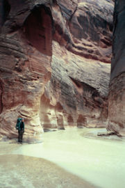
. It drains a rugged and arid region northwest of the Colorado, flowing through roadless slot canyon
Slot canyon
A slot canyon is a narrow canyon, formed by the wear of water rushing through rock. A slot canyon is significantly deeper than it is wide. Some slot canyons can measure less than one metre across at the top but drop more than 30 m to the floor of the canyon.Most slot canyons are formed in...
s along part of its course.
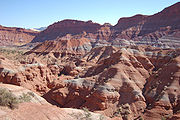
Geography
It is formed in southern Utah, in southwestern Garfield CountyGarfield County, Utah
Garfield County is a county located in the U.S. state of Utah. As of 2000 the population was 4,735. It was named for James A. Garfield, President of the United States in 1881. Its county seat and largest city is Panguitch.-Geography:...
from several creeks that descend from the edge of the Paunsaugunt Plateau
Paunsaugunt Plateau
The Paunsaugunt Plateau is a dissected plateau, rising to an elevation of , in southwestern Utah in the United States. Located in northern Kane County and southwestern Garfield County, it is approximately wide, and extends southward from the Sevier Plateau approximately , terminating in the Pink...
, meeting just north of Tropic
Tropic, Utah
Tropic is a town in Garfield County, Utah, United States, along Utah Scenic Byway 12. As of the 2000 census, the town had a total population of 508...
. It flows SSE across Kane County
Kane County, Utah
As of the census of 2000, there were 6,046 people, 2,237 households, and 1,628 families residing in the county. The population density was 2 people per square mile . There were 3,767 housing units at an average density of 1 per square mile...
and Grand Staircase-Escalante National Monument
Grand Staircase-Escalante National Monument
The Grand Staircase-Escalante National Monument contains 1.9 million acres of land in southern Utah, the United States. There are three main regions: the Grand Staircase, the Kaiparowits Plateau, and the Canyons of the Escalante. President Bill Clinton designated the area as a U.S. National...
. Along the Arizona state line, it descends through the Vermilion Cliffs
Vermilion Cliffs
The Vermilion Cliffs are the second "step" up in the five-step Grand Staircase of the Colorado Plateau. Reddish or vermilion-colored cliffs are found along U.S. Highway 89 and U.S. Highway 89A near Kanab, Utah . They extend from a location near Page, Arizona, west for a considerable distance, in...
in the Paria Canyon and onto the Paria Plateau. It joins the Colorado from the northwest approximately 5 mi (8 km) southwest of Page, Arizona
Page, Arizona
Page is a city in Coconino County, Arizona, United States, near the Glen Canyon Dam and Lake Powell. According to 2005 Census Bureau estimates, the population of the city is 6,794.-Geography:Page is located at ....
and the Glen Canyon Dam
Glen Canyon Dam
Glen Canyon Dam is a concrete arch dam on the Colorado River in northern Arizona in the United States, just north of Page. The dam was built to provide hydroelectricity and flow regulation from the upper Colorado River Basin to the lower. Its reservoir is called Lake Powell, and is the second...
. The lower 20 mi (32 km) of the river are within the Paria Canyon-Vermilion Cliffs Wilderness
Paria Canyon-Vermilion Cliffs Wilderness
The Paria Canyon-Vermilion Cliffs Wilderness is a wilderness area located in northern Arizona and southern Utah, USA, within the arid Colorado Plateau region. The wilderness is composed of broad plateaus, tall escarpments, and deep canyons....
, which is administered by the Bureau of Land Management
Bureau of Land Management
The Bureau of Land Management is an agency within the United States Department of the Interior which administers America's public lands, totaling approximately , or one-eighth of the landmass of the country. The BLM also manages of subsurface mineral estate underlying federal, state and private...
; a permit is required for any overnight visit. The Paria is essentially a large creek and is not navigable.
Attractions
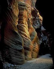
Buckskin Gulch
The Buckskin Gulch, a canyon in southern Utah, is one of the main tributaries of the Paria River, which is itself a minor tributary of the Colorado River. It is the longest and deepest slot canyon in the southwest United States and may very well be the longest in the world...
, a side canyon along the river in the narrows section, is considered to be one of the longest and deepest slot canyons in the United States. The Paria is also home to a number of important historical, geological and biological resources. Lee's Ferry
Lee's Ferry
Lee's Ferry is a site on the Colorado River in Coconino County, Arizona, United States, about 7.5 miles southwest of the town of Page, Arizona and the Glen Canyon Dam, and about 9 mi south of the Utah-Arizona border. It is the former location of a ferry established by John D. Lee, a Mormon...
and the adjoining settlement are located within the canyon just upstream of the confluence with the Colorado River, with a number of other abandoned settlements further north. The Paria and several nearby rivers and canyons also are the site of several well-preserved specimens of Native American
Native Americans in the United States
Native Americans in the United States are the indigenous peoples in North America within the boundaries of the present-day continental United States, parts of Alaska, and the island state of Hawaii. They are composed of numerous, distinct tribes, states, and ethnic groups, many of which survive as...
petroglyph
Petroglyph
Petroglyphs are pictogram and logogram images created by removing part of a rock surface by incising, picking, carving, and abrading. Outside North America, scholars often use terms such as "carving", "engraving", or other descriptions of the technique to refer to such images...
s, prehistoric drawings and symbols carved into stone. The Paria boasts a vibrant desert riparian habitat that is home to a number of sensitive and endangered species, and is also the location of Wrather Arch
Wrather Arch
Wrather Arch is the name of a natural arch in north Arizona. It is located in the eponymous Wrather Canyon, a small tributary of the Paria Canyon, which is itself an important tributary of the Colorado River...
, the longest natural arch
Natural arch
A natural arch or natural bridge is a natural geological formation where a rock arch forms, with an opening underneath. Most natural arches form as a narrow ridge, walled by cliffs, become narrower from erosion, with a softer rock stratum under the cliff-forming stratum gradually eroding out until...
outside of Utah
Utah
Utah is a state in the Western United States. It was the 45th state to join the Union, on January 4, 1896. Approximately 80% of Utah's 2,763,885 people live along the Wasatch Front, centering on Salt Lake City. This leaves vast expanses of the state nearly uninhabited, making the population the...
(although this claim may be superseded by Aloba Arch
Aloba Arch
Aloba Arch is the name of a natural arch located in the African nation of Chad. Large natural arches are somewhat rare outside of the Colorado Plateau of the southwest United States, although it is unknown if this is a true reflection of the geology or simply because many areas rich in sandstone,...
).
Ghost town
A ghost town is an abandoned town or city. A town often becomes a ghost town because the economic activity that supported it has failed, or due to natural or human-caused disasters such as floods, government actions, uncontrolled lawlessness, war, or nuclear disasters...
of Pahreah is the Paria Movie Set which was the site for a number of western movies. Among the movies filmed at this site and the surrounding area were The Outlaw Josey Wales
The Outlaw Josey Wales
The Outlaw Josey Wales is a 1976 American revisionist Western film set during and after the end of the American Civil War. It was directed by and starred Clint Eastwood , with Chief Dan George, Sondra Locke, Sam Bottoms, and Geraldine Keams.The film was adapted by Sonia Chernus and Philip Kaufman...
(1976), Sergeants 3 (1962), Westward the Women
Westward the Women
Westward the Women is a 1951 western film directed by William A. Wellman and starring Robert Taylor, Denise Darcel and John McIntire.-Plot:...
(1951), and Buffalo Bill
Buffalo Bill
William Frederick "Buffalo Bill" Cody was a United States soldier, bison hunter and showman. He was born in the Iowa Territory , in LeClaire but lived several years in Canada before his family moved to the Kansas Territory. Buffalo Bill received the Medal of Honor in 1872 for service to the US...
(1944). The old film set in the canyon was a popular attraction but was damaged in a flash flood in 1998. The buildings were dismantled and rebuilt in a nearby location by volunteers. In 2006 these new buildings were destroyed in a suspicious fire.