

Garfield County, Utah
Encyclopedia
Garfield County is a county located in the U.S. state
of Utah
. As of 2000 the population was 4,735. It was named for James A. Garfield, President of the United States
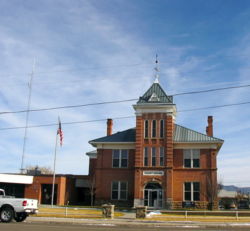
in 1881. Its county seat
and largest city is Panguitch
.
, the county has a total area of 5208 square miles (13,488.7 km²), of which 5174 square miles (13,400.6 km²) is land and 34 square miles (88.1 km²) (0.65%) is water. The Colorado River
, passing through a deep gorge, forms the eastern boundary. Westward, the cliffs of tributary canyons give way to the barren stretches of the San Rafael Desert, beyond which a variety of mountains, plateaus and canyons make up the terrain. Most of Bryce Canyon National Park
lies in the southwestern part of the county and the northern half of the Grand Staircase-Escalante National Monument
occupies the middle of the county. A large portion of Capitol Reef National Park
lies in the east-central part of the county. A very small part of Canyonlands National Park
lies in the northeast corner of the county.
National protected area
of 2000, there were 4,735 people, 1,576 households, and 1,199 families residing in the county. The population density
was 1 person per square mile (0/km²). There were 2,767 housing units at an average density of 0 per square mile (0/km²). The racial makeup of the county was 94.95% White
, 0.17% Black
or African American
, 1.84% Native American
, 0.40% Asian
, 0.04% Pacific Islander
, 1.12% from other races
, and 1.48% from two or more races. 2.87% of the population were Hispanic
or Latino
of any race.
There were 1,576 households out of which 38.40% had children under the age of 18 living with them, 66.40% were married couples
living together, 6.80% had a female householder with no husband present, and 23.90% were non-families. 20.50% of all households were made up of individuals and 10.10% had someone living alone who was 65 years of age or older. The average household size was 2.92 and the average family size was 3.43.
In the county, the population was spread out with 32.60% under the age of 18, 7.80% from 18 to 24, 23.10% from 25 to 44, 22.40% from 45 to 64, and 14.10% who were 65 years of age or older. The median age was 34 years. For every 100 females there were 104.60 males. For every 100 females age 18 and over, there were 102.20 males.
The median income for a household in the county was $35,180, and the median income for a family was $40,192. Males had a median income of $30,239 versus $20,408 for females. The per capita income
for the county was $13,439. About 6.10% of families and 8.10% of the population were below the poverty line, including 8.80% of those under age 18 and 10.40% of those age 65 or over.
U.S. state
A U.S. state is any one of the 50 federated states of the United States of America that share sovereignty with the federal government. Because of this shared sovereignty, an American is a citizen both of the federal entity and of his or her state of domicile. Four states use the official title of...
of Utah
Utah
Utah is a state in the Western United States. It was the 45th state to join the Union, on January 4, 1896. Approximately 80% of Utah's 2,763,885 people live along the Wasatch Front, centering on Salt Lake City. This leaves vast expanses of the state nearly uninhabited, making the population the...
. As of 2000 the population was 4,735. It was named for James A. Garfield, President of the United States
President of the United States
The President of the United States of America is the head of state and head of government of the United States. The president leads the executive branch of the federal government and is the commander-in-chief of the United States Armed Forces....
in 1881. Its county seat
County seat
A county seat is an administrative center, or seat of government, for a county or civil parish. The term is primarily used in the United States....
and largest city is Panguitch
Panguitch, Utah
Panguitch is a city in and the county seat of Garfield County, Utah, United States. The population was 1,623 at the 2000 census.-Geography:Panguitch is located at ....
.
Geography
According to the U.S. Census BureauUnited States Census Bureau
The United States Census Bureau is the government agency that is responsible for the United States Census. It also gathers other national demographic and economic data...
, the county has a total area of 5208 square miles (13,488.7 km²), of which 5174 square miles (13,400.6 km²) is land and 34 square miles (88.1 km²) (0.65%) is water. The Colorado River
Colorado River
The Colorado River , is a river in the Southwestern United States and northwestern Mexico, approximately long, draining a part of the arid regions on the western slope of the Rocky Mountains. The watershed of the Colorado River covers in parts of seven U.S. states and two Mexican states...
, passing through a deep gorge, forms the eastern boundary. Westward, the cliffs of tributary canyons give way to the barren stretches of the San Rafael Desert, beyond which a variety of mountains, plateaus and canyons make up the terrain. Most of Bryce Canyon National Park
Bryce Canyon National Park
Bryce Canyon National Park is a national park located in southwestern Utah in the United States. The major feature of the park is Bryce Canyon which, despite its name, is not a canyon but a giant natural amphitheater created by erosion along the eastern side of the Paunsaugunt Plateau...
lies in the southwestern part of the county and the northern half of the Grand Staircase-Escalante National Monument
Grand Staircase-Escalante National Monument
The Grand Staircase-Escalante National Monument contains 1.9 million acres of land in southern Utah, the United States. There are three main regions: the Grand Staircase, the Kaiparowits Plateau, and the Canyons of the Escalante. President Bill Clinton designated the area as a U.S. National...
occupies the middle of the county. A large portion of Capitol Reef National Park
Capitol Reef National Park
Capitol Reef National Park is a United States National Park, in south-central Utah. It is 100 miles long but fairly narrow. The park, established in 1971, preserves 378 mi² and is open all year, although May through September are the most popular months.Called "Wayne Wonderland" in the 1920s...
lies in the east-central part of the county. A very small part of Canyonlands National Park
Canyonlands National Park
Canyonlands National Park is a U.S. National Park located in southeastern Utah near the town of Moab and preserves a colorful landscape eroded into countless canyons, mesas and buttes by the Colorado River, the Green River, and their respective tributaries. The park is divided into four districts:...
lies in the northeast corner of the county.
Bordering Counties
- Wayne County, UtahWayne County, UtahWayne County is a county located in the U.S. state of Utah. It was formed from Piute County in 1892. The county gets its name from a man who served as delegate to the constitutional convention, in honor of his son who was dragged to death by a horse. As of 2000 the population was 2,509, and by...
- (north) - San Juan County, UtahSan Juan County, UtahAs of the current census of 2010, there were 14,746 people and 4,505 households. The racial and ethnic composition of the population was 50.4% Native American, 45.8% white, 0.3% Asian, 0.2% African American and 2.3% reporting two or more races...
- (east) - Kane County, UtahKane County, UtahAs of the census of 2000, there were 6,046 people, 2,237 households, and 1,628 families residing in the county. The population density was 2 people per square mile . There were 3,767 housing units at an average density of 1 per square mile...
- (south) - Iron County, UtahIron County, UtahAs of the census of 2000, there were 33,779 people, 10,627 households, and 8,076 families residing in the county. The population density was 10 people per square mile . There were 13,618 housing units at an average density of 4 per square mile...
- (west) - Beaver County, UtahBeaver County, UtahAs of the census of 2010, there were 6,629 people, 2,265 households, and 1,697 families residing in the county. The population density was 2.56 people per square mile . There were 2,908 housing units at an average density of 1.12 per square mile...
- (northwest) - Piute County, UtahPiute County, UtahPiute County is a county located in the U.S. state of Utah. The population in 2000 was 1,435, and by 2005 had been estimated to decrease to 1,365. It was named for the Paiute tribe of Native Americans. The county seat is Junction and the largest city is Circleville.-Geography:According to the U.S...
- (northwest)
National protected areaProtected areaProtected areas are locations which receive protection because of their recognised natural, ecological and/or cultural values. There are several kinds of protected areas, which vary by level of protection depending on the enabling laws of each country or the regulations of the international...
s
- Bryce Canyon National ParkBryce Canyon National ParkBryce Canyon National Park is a national park located in southwestern Utah in the United States. The major feature of the park is Bryce Canyon which, despite its name, is not a canyon but a giant natural amphitheater created by erosion along the eastern side of the Paunsaugunt Plateau...
(part) - Canyonlands National ParkCanyonlands National ParkCanyonlands National Park is a U.S. National Park located in southeastern Utah near the town of Moab and preserves a colorful landscape eroded into countless canyons, mesas and buttes by the Colorado River, the Green River, and their respective tributaries. The park is divided into four districts:...
(part) - Capitol Reef National ParkCapitol Reef National ParkCapitol Reef National Park is a United States National Park, in south-central Utah. It is 100 miles long but fairly narrow. The park, established in 1971, preserves 378 mi² and is open all year, although May through September are the most popular months.Called "Wayne Wonderland" in the 1920s...
(part) - Dixie National ForestDixie National ForestDixie National Forest is a United States National Forest in Utah with headquarters in Cedar City. It occupies almost two million acres and stretches for about 170 miles across southern Utah. The largest national forest in Utah, it straddles the divide between the Great Basin and the Colorado River...
(part) - Fishlake National ForestFishlake National ForestFishlake National Forest is located in south central Utah, USA. Its namesake is the largest freshwater mountain lake in the state.-Geography:...
(part) - Glen Canyon National Recreation AreaGlen Canyon National Recreation AreaGlen Canyon National Recreation Area is a recreation and conservation unit of the National Park Service that encompasses the area around Lake Powell and lower Cataract Canyon in Utah and Arizona, covering 1,254,429 acres of mostly desert...
(part) - Grand Staircase-Escalante National MonumentGrand Staircase-Escalante National MonumentThe Grand Staircase-Escalante National Monument contains 1.9 million acres of land in southern Utah, the United States. There are three main regions: the Grand Staircase, the Kaiparowits Plateau, and the Canyons of the Escalante. President Bill Clinton designated the area as a U.S. National...
(part)
Demographics
As of the censusCensus
A census is the procedure of systematically acquiring and recording information about the members of a given population. It is a regularly occurring and official count of a particular population. The term is used mostly in connection with national population and housing censuses; other common...
of 2000, there were 4,735 people, 1,576 households, and 1,199 families residing in the county. The population density
Population density
Population density is a measurement of population per unit area or unit volume. It is frequently applied to living organisms, and particularly to humans...
was 1 person per square mile (0/km²). There were 2,767 housing units at an average density of 0 per square mile (0/km²). The racial makeup of the county was 94.95% White
Race (United States Census)
Race and ethnicity in the United States Census, as defined by the Federal Office of Management and Budget and the United States Census Bureau, are self-identification data items in which residents choose the race or races with which they most closely identify, and indicate whether or not they are...
, 0.17% Black
Race (United States Census)
Race and ethnicity in the United States Census, as defined by the Federal Office of Management and Budget and the United States Census Bureau, are self-identification data items in which residents choose the race or races with which they most closely identify, and indicate whether or not they are...
or African American
Race (United States Census)
Race and ethnicity in the United States Census, as defined by the Federal Office of Management and Budget and the United States Census Bureau, are self-identification data items in which residents choose the race or races with which they most closely identify, and indicate whether or not they are...
, 1.84% Native American
Race (United States Census)
Race and ethnicity in the United States Census, as defined by the Federal Office of Management and Budget and the United States Census Bureau, are self-identification data items in which residents choose the race or races with which they most closely identify, and indicate whether or not they are...
, 0.40% Asian
Race (United States Census)
Race and ethnicity in the United States Census, as defined by the Federal Office of Management and Budget and the United States Census Bureau, are self-identification data items in which residents choose the race or races with which they most closely identify, and indicate whether or not they are...
, 0.04% Pacific Islander
Race (United States Census)
Race and ethnicity in the United States Census, as defined by the Federal Office of Management and Budget and the United States Census Bureau, are self-identification data items in which residents choose the race or races with which they most closely identify, and indicate whether or not they are...
, 1.12% from other races
Race (United States Census)
Race and ethnicity in the United States Census, as defined by the Federal Office of Management and Budget and the United States Census Bureau, are self-identification data items in which residents choose the race or races with which they most closely identify, and indicate whether or not they are...
, and 1.48% from two or more races. 2.87% of the population were Hispanic
Race (United States Census)
Race and ethnicity in the United States Census, as defined by the Federal Office of Management and Budget and the United States Census Bureau, are self-identification data items in which residents choose the race or races with which they most closely identify, and indicate whether or not they are...
or Latino
Race (United States Census)
Race and ethnicity in the United States Census, as defined by the Federal Office of Management and Budget and the United States Census Bureau, are self-identification data items in which residents choose the race or races with which they most closely identify, and indicate whether or not they are...
of any race.
There were 1,576 households out of which 38.40% had children under the age of 18 living with them, 66.40% were married couples
Marriage
Marriage is a social union or legal contract between people that creates kinship. It is an institution in which interpersonal relationships, usually intimate and sexual, are acknowledged in a variety of ways, depending on the culture or subculture in which it is found...
living together, 6.80% had a female householder with no husband present, and 23.90% were non-families. 20.50% of all households were made up of individuals and 10.10% had someone living alone who was 65 years of age or older. The average household size was 2.92 and the average family size was 3.43.
In the county, the population was spread out with 32.60% under the age of 18, 7.80% from 18 to 24, 23.10% from 25 to 44, 22.40% from 45 to 64, and 14.10% who were 65 years of age or older. The median age was 34 years. For every 100 females there were 104.60 males. For every 100 females age 18 and over, there were 102.20 males.
The median income for a household in the county was $35,180, and the median income for a family was $40,192. Males had a median income of $30,239 versus $20,408 for females. The per capita income
Per capita income
Per capita income or income per person is a measure of mean income within an economic aggregate, such as a country or city. It is calculated by taking a measure of all sources of income in the aggregate and dividing it by the total population...
for the county was $13,439. About 6.10% of families and 8.10% of the population were below the poverty line, including 8.80% of those under age 18 and 10.40% of those age 65 or over.
Cities and towns
- AntimonyAntimony, UtahAntimony is a town in Garfield County, Utah, United States. The population was 122 at the 2000 census, a small increase over the 1990 population of 83.-Geography:Antimony is located at ....
- BryceBryce, UtahBryce is an unincorporated community in southwestern Garfield County, Utah, United States, southeast of the city of Panguitch, the county seat of Garfield County. It lies along State Route 63 in the northern part of Bryce Canyon National Park. The community is distinct from the town of Bryce...
- Bryce Canyon CityBryce Canyon City, UtahBryce Canyon City is a town in Garfield County, Utah, United States, adjacent to Bryce Canyon National Park. The town, formerly known as Ruby's Inn, was officially incorporated on 23 July 2007 under a controversial, short-lived state law...
- BoulderBoulder, UtahBoulder is a town in Garfield County, Utah, United States, 27 miles northeast of Escalante on Utah Scenic Byway 12 at its intersection with the Burr Trail...
- CannonvilleCannonville, UtahCannonville is a town in Garfield County, Utah, United States, along Utah Scenic Byway 12. In the 2000 census, the population was 148, a small increase over the 1990 figure of 131.-Geography:Cannonville is located at ....
- EscalanteEscalante, UtahEscalante is a city in Garfield County, Utah, United States, along Utah Scenic Byway 12. As of the 2000 census, the city population was 818.The town was named after Silvestre Vélez de Escalante, a Franciscan missionary and the first European explorer in the region...
- HatchHatch, UtahHatch is a town in Garfield County, Utah, United States. The population was 127 at the 2000 census. It is approximately 217 miles from Salt Lake City.-Geography:...
- HenrievilleHenrieville, UtahHenrieville is a town in Garfield County, Utah, United States, along Utah Scenic Byway 12. As of the 2000 census, the town population was 159.-Geography:Henrieville is located at ....
- PanguitchPanguitch, UtahPanguitch is a city in and the county seat of Garfield County, Utah, United States. The population was 1,623 at the 2000 census.-Geography:Panguitch is located at ....
- TicabooTicaboo, UtahTicaboo is an unincorporated community in far southeastern Garfield County, Utah, United States. It lies along State Route 276 more than by air east of the city of Panguitch, the county seat of Garfield County. Its elevation is 4,265 feet . Although it is unincorporated, it has a post...
- TropicTropic, UtahTropic is a town in Garfield County, Utah, United States, along Utah Scenic Byway 12. As of the 2000 census, the town had a total population of 508...