

Oxley Highway
Encyclopedia
New South Wales
New South Wales is a state of :Australia, located in the east of the country. It is bordered by Queensland, Victoria and South Australia to the north, south and west respectively. To the east, the state is bordered by the Tasman Sea, which forms part of the Pacific Ocean. New South Wales...
, Australia
Australia
Australia , officially the Commonwealth of Australia, is a country in the Southern Hemisphere comprising the mainland of the Australian continent, the island of Tasmania, and numerous smaller islands in the Indian and Pacific Oceans. It is the world's sixth-largest country by total area...
. It starts at Nevertire
Nevertire, New South Wales
Nevertire is a rural village in New South Wales, Australia. It is located at the junction of the Mitchell Highway and the Oxley Highway, in Warren Shire. Nevertire is about 525 kilometres northwest of Sydney, 68 km north-west of Narromine and about 90 km from Dubbo. It is about...
where it joins the Mitchell Highway
Mitchell Highway
The Mitchell Highway is a major rural highway in Australia, travelling through central and northern New South Wales and south central Queensland. The highway starts from its northern end in Queensland with the Landsborough Highway near Augathella and continues south to Charleville and Cunnamulla...
. It links Warren
Warren, New South Wales
Warren is a town and the seat of a local government area, Warren Shire, on the Macquarie River in central New South Wales, Australia. The town is located on the Oxley Highway 120 kilometres north west of Dubbo. It was laid out in the 1860s and incorporated as a municipality in 1895. The railway...
, Gilgandra
Gilgandra, New South Wales
Gilgandra, is a town and Local Government Area in the Central West region of New South Wales, Australia. It is located on the junction of the Newell Highway, Oxley Highway and Castlereagh Highway. It can be reached in about six hours by car from Sydney. Like Coonabarabran, Gilgandra can be...
, Coonabarabran
Coonabarabran, New South Wales
Coonabarabran is a town in Warrumbungle Shire in northern New South Wales, Australia. At the 2006 census, the town had a population of 2,609.-History and description:...
, Gunnedah
Gunnedah, New South Wales
Gunnedah is a town and Local government area in north-eastern New South Wales, Australia. 7,542 people lived in the town of Gunnedah in 2006, including 931 indigenous people ....
, Carroll
Carroll, New South Wales
Carroll is a parish and small village on the Oxley Highway, 20 km east of Gunnedah, New South Wales. In 2006, Carroll had a population of 447 people. The Namoi River runs approximately parallel to the highway which is also the main street there. Periodically this river floods the town and...
, Tamworth
Tamworth, New South Wales
Tamworth is a city in the New England region of New South Wales, Australia. Straddling the Peel River, Tamworth, which contains an estimated population of 47,595 people, is the major regional centre for southern New England and in the local government area of Tamworth Regional Council. The city...
, Bendemeer
Bendemeer, New South Wales
Bendemeer is a village of 485 people on the Macdonald River in the New England region of New South Wales, Australia. It is situated at the junction of the New England and Oxley Highways.- History :...
, Walcha
Walcha, New South Wales
Walcha is a parish and town at the south-eastern edge of the Northern Tablelands, New South Wales, Australia.The town serves as the seat of Walcha Shire. Walcha is located 425 kilometres by road from Sydney at the intersection of the Oxley Highway and Thunderbolts Way...
, Yarrowitch
Yarrowitch, New South Wales
Yarrowitch is a parish and a small rural locality on the Northern Tablelands, New South Wales, Australia. It is located in the picturesque Yarrowitch River Valley on the Oxley Highway 48 kilometres east of Walcha. The settlement is included in the Walcha Shire Local Government Area in the New...
, Ellenborough
Ellenborough, New South Wales
Ellenborough is a parish and village straddling the Oxley Highway and the Ellenborough River, less than one kilometre south of its confluence with the Hastings River. The village is about 33 km west of Wauchope and approximately 71 km east of Walcha...
, Long Flat
Long Flat, New South Wales
Long Flat is a rural village situated on the Oxley Highway and the southern bank of the Hastings River. This village is about 30 kilometres west of Wauchope and approximately 75 km east of Walcha...
, Wauchope
Wauchope, New South Wales
-People from Wauchope:* Iva Davies - Musician, Icehouse* Alison Langdon - Channel Nine News Reader - Today Show* Phil Jamieson - Musician, Grinspoon* Andrew Stoner - NSW National Party of Australia leader, Member for Oxley...
and ends at Port Macquarie
Port Macquarie, New South Wales
Port Macquarie is a city on the Mid North Coast of New South Wales, Australia, located about north of Sydney, and south of Brisbane. The city is located on the coast, at the mouth of the Hastings River, and has an estimated population of 44,313....
on the coast of the Tasman Sea
Tasman Sea
The Tasman Sea is the large body of water between Australia and New Zealand, approximately across. It extends 2,800 km from north to south. It is a south-western segment of the South Pacific Ocean. The sea was named after the Dutch explorer Abel Janszoon Tasman, the first recorded European...
.
The Oxley Highway links with the Castlereagh Highway
Castlereagh Highway
The Castlereagh Highway is a state highway in New South Wales, Australia, also extending some kilometres into Queensland. It has been given the route number 55. The highway was recently extended past Gilgandra to include state route 86...
at Gilgandra
Gilgandra, New South Wales
Gilgandra, is a town and Local Government Area in the Central West region of New South Wales, Australia. It is located on the junction of the Newell Highway, Oxley Highway and Castlereagh Highway. It can be reached in about six hours by car from Sydney. Like Coonabarabran, Gilgandra can be...
, from where it is duplexed with the Newell Highway
Newell Highway
The Newell Highway is the longest highway in New South Wales, Australia. It runs parallel to the eastern coast about 400 kilometres inland, and is the main inland direct road link from Victoria to Queensland, bypassing the more congested coastal areas of New South Wales...
to Coonabarabran, the New England Highway
New England Highway
The New England Highway is a highway in Australia running from Hexham near Newcastle at its southern end to Yarraman near Toowoomba at its northern end. At its southern end it connects to the Pacific Highway and at its northern end it connects to the D'Aguilar Highway. It traverses the Hunter...
at Tamworth
Tamworth, New South Wales
Tamworth is a city in the New England region of New South Wales, Australia. Straddling the Peel River, Tamworth, which contains an estimated population of 47,595 people, is the major regional centre for southern New England and in the local government area of Tamworth Regional Council. The city...
, with which it is duplexed to Bendemeer, the Thunderbolts Way
Thunderbolts Way
Thunderbolts Way is a New South Wales country road linking Gloucester to Walcha , Uralla, where it very briefly joins the New England Highway and, to Copes Creek, south of the Gwydir Highway intersection at Inverell...
at Walcha
Walcha, New South Wales
Walcha is a parish and town at the south-eastern edge of the Northern Tablelands, New South Wales, Australia.The town serves as the seat of Walcha Shire. Walcha is located 425 kilometres by road from Sydney at the intersection of the Oxley Highway and Thunderbolts Way...
, and the Pacific Highway
Pacific Highway (Australia)
The Pacific Highway is a major transport route along part of the east coast of Australia and is part of Australia's national route 1.It is 960 km long and links Sydney, the capital of New South Wales, to Brisbane, the capital of Queensland, along the coast, via Gosford, Newcastle, Taree, Port...
near Port Macquarie
Port Macquarie, New South Wales
Port Macquarie is a city on the Mid North Coast of New South Wales, Australia, located about north of Sydney, and south of Brisbane. The city is located on the coast, at the mouth of the Hastings River, and has an estimated population of 44,313....
.
History
Northern Tablelands, New South Wales
The Northern Tablelands, also known as the New England Tableland, is a plateau and a region of the Great Dividing Range in northern New South Wales, Australia. It includes the New England Range, the narrow highlands area of the New England region, stretching from the Moonbi Range in the south to...
to Port Macquarie was opened for the first time. Wool
Wool
Wool is the textile fiber obtained from sheep and certain other animals, including cashmere from goats, mohair from goats, qiviut from muskoxen, vicuña, alpaca, camel from animals in the camel family, and angora from rabbits....
carried along this new route reduced the travelling time to 10 days, as opposed to 12-14 weeks for the trip to Maitland
Maitland, New South Wales
Maitland is a city in the Lower Hunter Valley of New South Wales, Australia and the seat of Maitland City Council, situated on the Hunter River approximately by road north of Sydney and north-west of Newcastle...
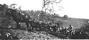
. The section from Walcha to Bendemeer existed as a mapped road in 1857, was surveyed in 1867, and proclaimed a Parish Road in c.1889. West of Walcha the road was only suitable for bullock teams and they too had difficulties, espescially with the ranges.
John Oxley
John Joseph William Molesworth Oxley was an explorer and surveyor of Australia in the early period of English colonisation.October 1802 he was engaged in coastal survey work including an expedition to Western Port in 1804-05...
who was the first European to explore much of inland New South Wales
New South Wales
New South Wales is a state of :Australia, located in the east of the country. It is bordered by Queensland, Victoria and South Australia to the north, south and west respectively. To the east, the state is bordered by the Tasman Sea, which forms part of the Pacific Ocean. New South Wales...
in 1818. On 30 September 1933 the Highway section between Walcha and Port Macquarie was officially opened. Walcha Shire maintained 106 km of the Highway until July 1966 when this part was taken over by the Department of Main Roads
Department of Main Roads (New South Wales)
The New South Wales Department of Main Roads was created in November 1932. The DMR undertook works across NSW; including maintenance of all major roads into Sydney and programs of road reconstruction, construction, upgrading and rerouting...
.
About 45 kilometres of the Yarrowitch to Wauchope section is unfenced and livestock
Livestock
Livestock refers to one or more domesticated animals raised in an agricultural setting to produce commodities such as food, fiber and labor. The term "livestock" as used in this article does not include poultry or farmed fish; however the inclusion of these, especially poultry, within the meaning...
(cattle) may be encountered there, along with other wild animals on most of the highway. Kangaroo
Kangaroo
A kangaroo is a marsupial from the family Macropodidae . In common use the term is used to describe the largest species from this family, especially those of the genus Macropus, Red Kangaroo, Antilopine Kangaroo, Eastern Grey Kangaroo and Western Grey Kangaroo. Kangaroos are endemic to the country...
s are the most likely of those to be spotted, but wombat
Wombat
Wombats are Australian marsupials; they are short-legged, muscular quadrupeds, approximately in length with a short, stubby tail. They are adaptable in their habitat tolerances, and are found in forested, mountainous, and heathland areas of south-eastern Australia, including Tasmania, as well as...
s and other marsupials may be found.
Attractions
The Wauchope to Walcha section and southwards along Thunderbolts Way is a very popular motorcycle ride in Australia as these roads wind their way up and down the scenic mountains of the Great Dividing RangeGreat Dividing Range
The Great Dividing Range, or the Eastern Highlands, is Australia's most substantial mountain range and the third longest in the world. The range stretches more than 3,500 km from Dauan Island off the northeastern tip of Queensland, running the entire length of the eastern coastline through...
.
A major attraction at Wauchope is the Timbertown
Timbertown
Timbertown is a popular attraction, depicting the colonial era of a sawmiller's village in northern New South Wales. It is located on 39 hectares of coastal blackbutt forest on the Oxley Highway at Wauchope in Australia...
Pioneer Village which is a very good old timber town of the 1880s set on 87 acres (352,076.8 m²). West of Timbertown the highway passes along the northern boundary of the Bago Bluff National Park
Bago Bluff National Park
Bago Bluff is a national park in New South Wales, Australia, approximately 410 km northeast of Sydney. It is situated south west of Wauchope and includes parts of the former Broken Bago State Forest and a part of Lorne State Forest...
. After leaving Ellenborough the highway traverses through the Cottan-Bimbang National Park
Cottan-Bimbang National Park
Cottan-Bimbang is a national park in New South Wales, Australia, 443 km north of Sydney and 65 km south east of Walcha and was formerly a state forest. The Oxley Highway crosses the park south of Werrikimbe National Park...
and the northern edge of the Mummel Gulf National Park
Mummel Gulf National Park
Mummel Gulf is a national park in New South Wales , about 487 kilometres by road north of Sydney. It is situated approximately 50 km southeast of Walcha on the unsealed Enfield Forest Road and 12 km south of the Oxley Highway....
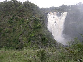
. The Apsley Falls
Apsley Falls
The Apsley Falls are two waterfalls on the Apsley River on the Northern Tablelands, New South Wales, Australia. The falls are located about east of Walcha, and 1 kilometre off the Oxley Highway in a deep gorge, that is part of the Oxley Wild Rivers National Park...
are easily accessible on a 1 km sealed side road and the Tia Falls and are quite spectacular, too, with good facilities available at each. Walcha has the unique Open Air Gallery, fossicking opportunities, Amaroo Museum & Cultural Centre, Pioneer Cottage museum and the local history archives.
The Gunnedah Rural Museum, containing farm machinery, equipment, a gun collection, photography and other artefacts is located on the Oxley Highway, 1 km west of the post office.
Near Coonabarabran, 2 km west of the town centre, on the National Park Road, is the Skywatch Observatory. Its attractions include hands-on usage of powerful telescopes. Hickey's Falls are located at the end of a short walking track which departs from a roadside stop, 42 km south-west of Coonabarabran on the Oxley Highway, en route to Gilgandra. Picnic and barbecue facilities are available.