
Yarrowitch, New South Wales
Encyclopedia
Northern Tablelands, New South Wales
The Northern Tablelands, also known as the New England Tableland, is a plateau and a region of the Great Dividing Range in northern New South Wales, Australia. It includes the New England Range, the narrow highlands area of the New England region, stretching from the Moonbi Range in the south to...
, Australia
Australia
Australia , officially the Commonwealth of Australia, is a country in the Southern Hemisphere comprising the mainland of the Australian continent, the island of Tasmania, and numerous smaller islands in the Indian and Pacific Oceans. It is the world's sixth-largest country by total area...
. It is located in the picturesque Yarrowitch River Valley on the Oxley Highway
Oxley Highway
The Oxley Highway is a rural highway in New South Wales, Australia. It starts at Nevertire where it joins the Mitchell Highway. It links Warren, Gilgandra, Coonabarabran, Gunnedah, Carroll, Tamworth, Bendemeer, Walcha, Yarrowitch, Ellenborough, Long Flat, Wauchope and ends at Port Macquarie on the...
48 kilometres east of Walcha
Walcha, New South Wales
Walcha is a parish and town at the south-eastern edge of the Northern Tablelands, New South Wales, Australia.The town serves as the seat of Walcha Shire. Walcha is located 425 kilometres by road from Sydney at the intersection of the Oxley Highway and Thunderbolts Way...
. The settlement is included in the Walcha Shire Local Government Area
Local Government Area
A local government area is an administrative division of a country that a local government is responsible for. The size of an LGA varies by country but it is generally a subdivision of a state, province, division, or territory....
in the New England
New England (Australia)
New England or New England North West is the name given to a generally undefined region about 60 kilometres inland, that includes the Northern Tablelands and the North West Slopes regions in the north of the state of New South Wales, Australia.-History:The region has been occupied by Indigenous...
region. The locality is at an elevation of about 995 metres and the area is part of Vernon County
Vernon County, New South Wales
Vernon County is one of the 141 Cadastral divisions of New South Wales, Australia. The Macleay River is part of the border in the north-east. It includes Walcha.Vernon County was named in honour of George John Venables-Vernon, 5th Baron Vernon ....
. At the 2006 census
Census in Australia
The Australian census is administered once every five years by the Australian Bureau of Statistics. The most recent census was conducted on 9 August 2011; the next will be conducted in 2016. Prior to the introduction of regular censuses in 1961, they had also been run in 1901, 1911, 1921, 1933,...
(held on 8 August 2006), the Yarrowitch area had a population of 128.
History
John OxleyJohn Oxley
John Joseph William Molesworth Oxley was an explorer and surveyor of Australia in the early period of English colonisation.October 1802 he was engaged in coastal survey work including an expedition to Western Port in 1804-05...
's expedition passed through Yarrowitch on 17 September 1818. They camped overnight on the eastern side of the River, before traversing the steep, rugged terrain and almost impenetrable scrub on their way to Port Macquarie.
The name, Yarrowitch, was probably derived from the English place name Yarrow, although there is an Aboriginal word 'Yarrawee', said to mean 'gum tree growing in water'.
John Allman and N. Powell occupied the area in c.1836. Shortly afterwards they were joined by Allman's brother, Francis. In about 1839 the Allmans were joined by Arthur Hodgson and by the end of that year the land had been divided into two sections. The following year, 1840, runs were acquired by Alexander Todd and Christopher Dawson Fenwicke. They were the first licensed lessees of Yarrowitch. Todd, licence 114, held east Yarrowitch containing 32000 acres (129.5 km²), and Fenwicke, licence 53, held western Yarrowitch containing 30400 acres (123 km²).
The Robertson Land Acts
Robertson Land Acts
The Crown Lands Acts 1861 were introduced by the New South Wales Premier, John Robertson, in 1861 to reform land holdings and in particular to break the squatters' domination of land tenure...
introduced in 1861 enabled small farmers to select blocks of Crown Land
Crown land
In Commonwealth realms, Crown land is an area belonging to the monarch , the equivalent of an entailed estate that passed with the monarchy and could not be alienated from it....
, and this further expanded the area. By 1900 the Yarrowitch district was fairly well established and an item from the Walcha Witness in 1898 gave an insight into life at Yarrowitch at the time ... "Yarrowitch News . . . Matters are looking up this way lately as regards selecting and new buildings. The new school building has been erected on a more sheltered situation and reflects credit on the contractor's workmanship. What with wheat and maize growing, pig farming and onion growing, some of the more recent selectors have now fairly lined pockets. The potato crop turned out fairly well but from appearances, wheat is going to be a general favourite with us". As well as these farming crops, cattle and sheep grazing and Australian Red Cedar cutting were the main sources of income.
In 1948 the New South Wales Department of Lands purchased Yarrowitch Station for closer settlement under the Lands Settlement Act. The property was then divided into seventeen blocks which were balloted out to returned soldiers and their families.
Most of the district was able to have a telephone connected in the 1930s. Yarrowitch settlement was connected to 240 volt electricity in 1962, although many outlying areas such as Kangaroo Flat were still unconnected. In 1977 the Oxley Highway was sealed to Walcha and Port Macquarie which made for much better access to these towns. Previously travel along this road was at the mercy of the weather which had sometimes meant that some of the hills became too slippery to negotiate.
During the 1980s the property Glenferrie in the Kangaroo Flat area was split up into many small blocks. Quite a few of the owners of these blocks only visited their land on the weekends and were known as “weekend or hobby farmers”.
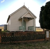
Yarrowitch has a church, public school, sports ground and a community hall.
Attractions
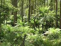
Werrikimbe National ParkWerrikimbe National Park
Werrikimbe National Park is in the catchment zone of the Upper Hastings River, New South Wales, Australia, about 486 km north of Sydney. This national park is about 80 km west of Wauchope and 90 km east of Walcha on the eastern escarpment of the Great Dividing Range...
, a large and remote World Heritage listed park is situated on the end of the Kangaroo Flat Road about 26 kilometres from Yarrowitch. Most of Werrikimbe Park is protected under the World Heritage list, which recognises places of outstanding importance across the planet. The National Park is home to the rare mammal, the Hastings River Mouse
Hastings River Mouse
The Hastings River Mouse is a species of rodent in the family Muridae.It is found only in Australia.-Habitat:These rodents often prefer damp and moist environments, along drainage lines if necessary...
, considered to be in imminent danger of extinction.
See also
- Soldier settlement (Australia)Soldier settlement (Australia)Soldier settlement refers to the occupation and settlement of land throughout parts of Australia by returning discharged soldiers under schemes administered by the State Governments after World Wars I and II.- World War I :...