

Cottan-Bimbang National Park
Encyclopedia
New South Wales
New South Wales is a state of :Australia, located in the east of the country. It is bordered by Queensland, Victoria and South Australia to the north, south and west respectively. To the east, the state is bordered by the Tasman Sea, which forms part of the Pacific Ocean. New South Wales...
, Australia
Australia
Australia , officially the Commonwealth of Australia, is a country in the Southern Hemisphere comprising the mainland of the Australian continent, the island of Tasmania, and numerous smaller islands in the Indian and Pacific Oceans. It is the world's sixth-largest country by total area...
, 443 km north of Sydney
Sydney
Sydney is the most populous city in Australia and the state capital of New South Wales. Sydney is located on Australia's south-east coast of the Tasman Sea. As of June 2010, the greater metropolitan area had an approximate population of 4.6 million people...
and 65 km south east of Walcha
Walcha, New South Wales
Walcha is a parish and town at the south-eastern edge of the Northern Tablelands, New South Wales, Australia.The town serves as the seat of Walcha Shire. Walcha is located 425 kilometres by road from Sydney at the intersection of the Oxley Highway and Thunderbolts Way...
and was formerly a state forest. The Oxley Highway
Oxley Highway
The Oxley Highway is a rural highway in New South Wales, Australia. It starts at Nevertire where it joins the Mitchell Highway. It links Warren, Gilgandra, Coonabarabran, Gunnedah, Carroll, Tamworth, Bendemeer, Walcha, Yarrowitch, Ellenborough, Long Flat, Wauchope and ends at Port Macquarie on the...
crosses the park south of Werrikimbe National Park
Werrikimbe National Park
Werrikimbe National Park is in the catchment zone of the Upper Hastings River, New South Wales, Australia, about 486 km north of Sydney. This national park is about 80 km west of Wauchope and 90 km east of Walcha on the eastern escarpment of the Great Dividing Range...
. Myrtle Scrub Road is a 15 kilometre circuit in the west of the park that connects with the Oxley Highway.
Flora and fauna
This park is situated on the eastern escarpment with extensive tall old-growth eucalypt forest, rainforest, threatened frog species, yellow-bellied gliderYellow-bellied Glider
The Yellow-bellied Glider is an arboreal and nocturnal gliding possum that lives in a narrow range of native eucalypt forests down eastern Australia, reaching from northern Queensland to Victoria.-Habitat:...
s (Petaurus australis) and koala
Koala
The koala is an arboreal herbivorous marsupial native to Australia, and the only extant representative of the family Phascolarctidae....
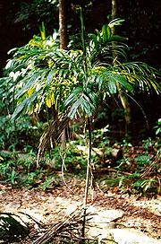
s. 'Cottan-bimbang' is the local Aboriginal word for the walking stick palm (Linospadix
Linospadix
Linospadix is a genus of flowering plant in the Arecaceae family.It contains the following species:* Linospadix longicruris* Linospadix microcarya* Linospadix minor Minor Walking Stick Palm...
monostachya), which grows in the park's temperate rainforests.
Blackberries (Rubus
Rubus
Rubus is a large genus of flowering plants in the rose family, Rosaceae, subfamily Rosoideae. Raspberries, blackberries, and dewberries are common, widely distributed members of the genus. Most of these plants have woody stems with prickles like roses; spines, bristles, and gland-tipped hairs are...
) are creating a serious weed problem in the park.
There is a barbecue area, picnic area and public toilets at Stockyard Creek on the Oxley Highway and a cleared area for picnics next to Cells River on Myrtle Scrub Road. There is a cleared area for camping at Maxwells Flat on the Causeway Road, and a long drop toilet.