
Otaki, Chiba
Encyclopedia
is a town
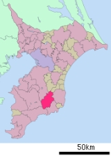
located in Isumi District, Chiba
, Japan
, occupying the center of the Bōsō Peninsula
. The town is known for its association with Edo period
general Honda Tadakatsu
and its prominent castle
. As of 2010, the town had an estimated population
of 10,794 and a population density
of 83.1 persons per km². The total area the town is 129.83 km², making it the largest of Chiba Prefecture
's towns and villages.
The name of the city is made of three characters: the first, ō (大), meaning "large", the second, ta (多), meaning "many", and the third, ki (喜), meaning "happiness".
flows through the town to the northeast, and in the western part of the town the Yōrō River
flows to the north.
remains in Oikawa. In the Asuka period
the Ōtaki region became part of Kazusa Province
at the western end of the Tōkaidō region
, which was formed as a result of the Taika Reform
of 654. In the Sengoku period
Ōtaki was established as a castle town, which successively controlled by different regional clans, most notably the Takeda clan and the Toki clan
. The Ōtaki region ultimately came under the control of the powerful Awa Province
-based Satomi clan
in 1544.
. Ieyasu granted Ōtaki to his famed general Honda Tadakatsu
, and established the Ōtaki Domain
as a 100,000 koku
feudal domain. Tadakatsu built Ōtaki Castle
on the site of the earlier castle and laid out a large-scale castle town. Honda Tadakatsu's placement at Ōtaki was a strong buffer against the military power of the Satomi clan to the south. The ownership of the castle changed hands many times after Honda Tadakatsu's control, but from 1703 the Matsudaira clan
held the castle for nine generations. Despite the Matsudaira clan's control of the castle, the majority of the Ōtaki region was controlled as tenryō territory by hatamoto
in direct service to the Tokugawa Shogunate
. In 1609 a Spanish Galleon
, the San Francisco, ran aground near Ōtaki . The survivors were housed in Ōtaki Castle, and later, the sailors were given a ship by the Tokugawa Shogunate
to return to Mexico
. One of the survivors was Governor General of the Philippines Rodrigo de Vivero, who was subsequently granted an audience with Shogun
Tokugawa Ieyasu
.
the administrative structure of the region changed frequently. Ōtaki was successively part of Ōtaki Prefecture, then Kisarazu Prefecture, before becoming part of the present-day Chiba Prefecture. In 1889, under the same administrative reforms, the four villages of Oikawa, Nishihata, Fusamoto, Kamitaki and the town of Ōtaki were formed. The five were brought together to become present-day town of Ōtaki on October 5, 1954.
production, forestry
, and traditional charcoal
production, but after World War II
all three industries have declined. The town produces shiitake
mushrooms and bamboo
roots as special agricultural products. Tourism has increased as a result of visits to Ōtaki Castle, the Ōtaki Prefectural Forest, and various scenic spots. Golf courses were developed in Ōtaki, but have caused problems with flooding and deforestation
.
, Mexico
, often visit to attend the festival.
Towns of Japan
A town is a local administrative unit in Japan. It is a local public body along with prefecture , city , and village...
located in Isumi District, Chiba
Isumi District, Chiba
is a district located in Chiba, Japan. As of 2010, the district has an estimated population of 18,593 and a density of 120 persons per km². The total area was 154.76 km². The district formerly included all of the city of Katsuura, most of the city of Isumi and a portion of the town of Mutsuzawa...
, Japan
Japan
Japan is an island nation in East Asia. Located in the Pacific Ocean, it lies to the east of the Sea of Japan, China, North Korea, South Korea and Russia, stretching from the Sea of Okhotsk in the north to the East China Sea and Taiwan in the south...
, occupying the center of the Bōsō Peninsula
Boso Peninsula
thumb|Locationthumb|Landsat image with high-resolution data from Space Shuttle is a peninsula in Chiba prefecture on Honshū, the largest island of Japan. It forms the eastern edge of Tokyo Bay, separating it from the Pacific Ocean....
. The town is known for its association with Edo period
Edo period
The , or , is a division of Japanese history which was ruled by the shoguns of the Tokugawa family, running from 1603 to 1868. The political entity of this period was the Tokugawa shogunate....
general Honda Tadakatsu
Honda Tadakatsu
, also called Honda Heihachirō , was a Japanese general of the late Sengoku through early Edo period, who served Tokugawa Ieyasu. Honda Tadakatsu was one of the Tokugawa Four Heavenly Kings along with Ii Naomasa, Sakakibara Yasumasa and Sakai Tadatsugu. - Biography :A native of Mikawa Province in...
and its prominent castle
Japanese castle
' were fortresses composed primarily of wood and stone. They evolved from the wooden stockades of earlier centuries, and came into their best-known form in the 16th century...
. As of 2010, the town had an estimated population
Population
A population is all the organisms that both belong to the same group or species and live in the same geographical area. The area that is used to define a sexual population is such that inter-breeding is possible between any pair within the area and more probable than cross-breeding with individuals...
of 10,794 and a population density
Population density
Population density is a measurement of population per unit area or unit volume. It is frequently applied to living organisms, and particularly to humans...
of 83.1 persons per km². The total area the town is 129.83 km², making it the largest of Chiba Prefecture
Chiba Prefecture
is a prefecture of Japan located in the Kantō region and the Greater Tokyo Area. Its capital is Chiba City.- History :Chiba Prefecture was established on June 15, 1873 with the merger of Kisarazu Prefecture and Inba Prefecture...
's towns and villages.
The name of the city is made of three characters: the first, ō (大), meaning "large", the second, ta (多), meaning "many", and the third, ki (喜), meaning "happiness".
Geography
Ōtaki is a landlocked town in the center of the Bōsō Peninsula. The southwest area of Otaki is mountainous, with altitudes gradually lowering towards the northeast of the town. 70% of Ōtaki is covered by forest. The Isumi RiverIsumi River
The is a river in Chiba Prefecture, Japan. It is in length and has a drainage area of . Under the Rivers Act of 1906 the Isumi is designated as a Class 2 River. Additionally, the government has designated the Isumi River a national-level .-Geography:...
flows through the town to the northeast, and in the western part of the town the Yōrō River
Yōrō River
The is a river in Chiba Prefecture, Japan. It is in length and has a drainage area of . Under the Rivers Act of 1906 the Yōrō is designated as a Class 2 River....
flows to the north.
Surrounding municipalities
- IchiharaIchihara, Chibais a city located in Chiba Prefecture, Japan. As of August 2010, the city has an estimated population of 279,080, with a population density of 758 persons per km². The total area of Ichihara was 368.20 km²...
- KimitsuKimitsu, Chibais a city located in Chiba, Japan. As of September 2010, the city had an estimated population of 88,661 and a population density of 278 persons per km². The total area was 318.83 km².-Geography:...
- KatsuuraKatsuura, Chibais a city located in southern part of Chiba Prefecture, Japan. Katsuura city is famous for Katsuura Fishing Port, which features one of the top three largest morning markets in Japan. As of February 2010, the city has an estimated population of 20,570 and the density of 218 persons per km²...
- KamogawaKamogawa, Chibais a city located in Chiba Prefecture, Japan.As of 2010, the city had an estimated population of 35,257 and a population density of 184 persons per km². The total area was 191.30 km²...
- Isumi CityIsumi, Chibais a city in Chiba Prefecture, Japan. As of March 1, 2010, the city has a population of 41,014 in an area of 157.50 km².Tōkyō Station is reached from Isumi by express train in 1 hour and 10 minutes via Ōhara Station on the JR East Sotobō Line.-Geography:...
- MutsuzawaMutsuzawa, Chibais a town located in Chōsei District, Chiba, Japan.As of 2010, the town has an estimated population of 7,419 and a density of 208 persons per km². The total area is 35.59 km².-Geography:...
- ChōnanChonan, Chibais a town located in Chōsei District, Chiba, Japan.As of 2010 estimates, the town had a population of 9,154 and a density of 140 persons per km². The total area was .- Geography :...
Early history
Ōtaki was settled in perhistoric times, as evidenced by the Jōmon periodJomon period
The is the time in Japanese prehistory from about 14,000 BC to 300 BC.The term jōmon means "cord-patterned" in Japanese. This refers to the pottery style characteristic of the Jōmon culture, and which has markings made using sticks with cords wrapped around them...
remains in Oikawa. In the Asuka period
Asuka period
The , was a period in the history of Japan lasting from 538 to 710 , although its beginning could be said to overlap with the preceding Kofun period...
the Ōtaki region became part of Kazusa Province
Kazusa Province
was a province of Japan in the area of modern Chiba Prefecture. It lies on in the middle of the Bōsō Peninsula , whose name takes its first kanji from the name of Awa Province and its second from Kazusa and Shimōsa Provinces. Its abbreviated form name was or .Kazusa is classified as one of the...
at the western end of the Tōkaidō region
Tokaido (region)
The was originally an old Japanese geographical region that made up the gokishichidō system and was situated along the southeastern edge of Honshū, its name literally meaning 'Eastern Sea Way'....
, which was formed as a result of the Taika Reform
Taika Reform
The ' were a set of doctrines established by Emperor Kōtoku in the year 645. They were written shortly after the death of Prince Shōtoku, and the defeat of the Soga clan , uniting Japan. Crown Prince Naka no Ōe , Nakatomi no Kamatari, and Emperor Kōtoku jointly embarked on the details of the Reforms...
of 654. In the Sengoku period
Sengoku period
The or Warring States period in Japanese history was a time of social upheaval, political intrigue, and nearly constant military conflict that lasted roughly from the middle of the 15th century to the beginning of the 17th century. The name "Sengoku" was adopted by Japanese historians in reference...
Ōtaki was established as a castle town, which successively controlled by different regional clans, most notably the Takeda clan and the Toki clan
Toki clan
The was a powerful clan that ruled in Japan from the Kamakura period to the Edo period. It descended from Emperor Seiwa by Minamoto no Yorimitsu from the Minamoto clan and used Toki in Mino Province as their hometown...
. The Ōtaki region ultimately came under the control of the powerful Awa Province
Awa Province (Chiba)
was a province of Japan in the area of modern Chiba Prefecture. It lies on the tip of the Boso Peninsula , whose name takes its first kanji from the name of Awa Province and its second from Kazusa and Shimōsa Provinces. Its abbreviated form name was or...
-based Satomi clan
Satomi clan
The Satomi clan was a clan of samurai which claimed descent from Nitta Yoshishige , whose son Yoshitoshi took 'Satomi' as his surname. The Satomi moved from Kōzuke province to Awa province in the mid-15th century, and remained there into the Edo Period. During the Sengoku period, the Satomi were...
in 1544.
Edo Period
In 1590 Tokugawa Ieyasu took control of all of Kazusa ProvinceKazusa Province
was a province of Japan in the area of modern Chiba Prefecture. It lies on in the middle of the Bōsō Peninsula , whose name takes its first kanji from the name of Awa Province and its second from Kazusa and Shimōsa Provinces. Its abbreviated form name was or .Kazusa is classified as one of the...
. Ieyasu granted Ōtaki to his famed general Honda Tadakatsu
Honda Tadakatsu
, also called Honda Heihachirō , was a Japanese general of the late Sengoku through early Edo period, who served Tokugawa Ieyasu. Honda Tadakatsu was one of the Tokugawa Four Heavenly Kings along with Ii Naomasa, Sakakibara Yasumasa and Sakai Tadatsugu. - Biography :A native of Mikawa Province in...
, and established the Ōtaki Domain
Otaki Domain
was a Japanese domain of the Edo period, located in Kazusa Province , Japan. It was centered on Ōtaki Castle in what is now the town of Ōtaki, Chiba.-History:...
as a 100,000 koku
Koku
The is a Japanese unit of volume, equal to ten cubic shaku. In this definition, 3.5937 koku equal one cubic metre, i.e. 1 koku is approximately 278.3 litres. The koku was originally defined as a quantity of rice, historically defined as enough rice to feed one person for one year...
feudal domain. Tadakatsu built Ōtaki Castle
Ōtaki Castle (Chiba)
is a Japanese castle located in Ōtaki, southeast Chiba Prefecture, Japan. In the Edo period, Ōtaki Castle was home to the daimyō of Ōtaki Domain of Kazusa Province, the Satomi clan...
on the site of the earlier castle and laid out a large-scale castle town. Honda Tadakatsu's placement at Ōtaki was a strong buffer against the military power of the Satomi clan to the south. The ownership of the castle changed hands many times after Honda Tadakatsu's control, but from 1703 the Matsudaira clan
Matsudaira clan
The was a Japanese samurai clan that claimed descent from the Minamoto clan. It first originated in and took its name from Matsudaira village, in Mikawa Province . Over the course of its history, the clan produced many branches, most of which also centered around Mikawa Province...
held the castle for nine generations. Despite the Matsudaira clan's control of the castle, the majority of the Ōtaki region was controlled as tenryō territory by hatamoto
Hatamoto
A was a samurai in the direct service of the Tokugawa shogunate of feudal Japan. While all three of the shogunates in Japanese history had official retainers, in the two preceding ones, they were referred to as gokenin. However, in the Edo period, hatamoto were the upper vassals of the Tokugawa...
in direct service to the Tokugawa Shogunate
Tokugawa shogunate
The Tokugawa shogunate, also known as the and the , was a feudal regime of Japan established by Tokugawa Ieyasu and ruled by the shoguns of the Tokugawa family. This period is known as the Edo period and gets its name from the capital city, Edo, which is now called Tokyo, after the name was...
. In 1609 a Spanish Galleon
Manila Galleon
The Manila galleons or Manila-Acapulco galleons were Spanish trading ships that sailed once or twice per year across the Pacific Ocean between Manila in the Philippines, and Acapulco, New Spain . The name changed reflecting the city that the ship was sailing from...
, the San Francisco, ran aground near Ōtaki . The survivors were housed in Ōtaki Castle, and later, the sailors were given a ship by the Tokugawa Shogunate
Tokugawa shogunate
The Tokugawa shogunate, also known as the and the , was a feudal regime of Japan established by Tokugawa Ieyasu and ruled by the shoguns of the Tokugawa family. This period is known as the Edo period and gets its name from the capital city, Edo, which is now called Tokyo, after the name was...
to return to Mexico
Mexico
The United Mexican States , commonly known as Mexico , is a federal constitutional republic in North America. It is bordered on the north by the United States; on the south and west by the Pacific Ocean; on the southeast by Guatemala, Belize, and the Caribbean Sea; and on the east by the Gulf of...
. One of the survivors was Governor General of the Philippines Rodrigo de Vivero, who was subsequently granted an audience with Shogun
Shogun
A was one of the hereditary military dictators of Japan from 1192 to 1867. In this period, the shoguns, or their shikken regents , were the de facto rulers of Japan though they were nominally appointed by the emperor...
Tokugawa Ieyasu
Tokugawa Ieyasu
was the founder and first shogun of the Tokugawa shogunate of Japan , which ruled from the Battle of Sekigahara in 1600 until the Meiji Restoration in 1868. Ieyasu seized power in 1600, received appointment as shogun in 1603, abdicated from office in 1605, but...
.
Modern Period
After the Meiji RestorationMeiji Restoration
The , also known as the Meiji Ishin, Revolution, Reform or Renewal, was a chain of events that restored imperial rule to Japan in 1868...
the administrative structure of the region changed frequently. Ōtaki was successively part of Ōtaki Prefecture, then Kisarazu Prefecture, before becoming part of the present-day Chiba Prefecture. In 1889, under the same administrative reforms, the four villages of Oikawa, Nishihata, Fusamoto, Kamitaki and the town of Ōtaki were formed. The five were brought together to become present-day town of Ōtaki on October 5, 1954.
Economy
The economy of Ōtaki was based largely on riceRice
Rice is the seed of the monocot plants Oryza sativa or Oryza glaberrima . As a cereal grain, it is the most important staple food for a large part of the world's human population, especially in East Asia, Southeast Asia, South Asia, the Middle East, and the West Indies...
production, forestry
Forestry
Forestry is the interdisciplinary profession embracing the science, art, and craft of creating, managing, using, and conserving forests and associated resources in a sustainable manner to meet desired goals, needs, and values for human benefit. Forestry is practiced in plantations and natural stands...
, and traditional charcoal
Charcoal
Charcoal is the dark grey residue consisting of carbon, and any remaining ash, obtained by removing water and other volatile constituents from animal and vegetation substances. Charcoal is usually produced by slow pyrolysis, the heating of wood or other substances in the absence of oxygen...
production, but after World War II
World War II
World War II, or the Second World War , was a global conflict lasting from 1939 to 1945, involving most of the world's nations—including all of the great powers—eventually forming two opposing military alliances: the Allies and the Axis...
all three industries have declined. The town produces shiitake
Shiitake
The Shiitake is an edible mushroom native to East Asia, which is cultivated and consumed in many Asian countries, as well as being dried and exported to many countries around the world. It is a feature of many Asian cuisines including Vietnamese, Chinese, Japanese, Korean and Thai...
mushrooms and bamboo
Bamboo
Bamboo is a group of perennial evergreens in the true grass family Poaceae, subfamily Bambusoideae, tribe Bambuseae. Giant bamboos are the largest members of the grass family....
roots as special agricultural products. Tourism has increased as a result of visits to Ōtaki Castle, the Ōtaki Prefectural Forest, and various scenic spots. Golf courses were developed in Ōtaki, but have caused problems with flooding and deforestation
Deforestation
Deforestation is the removal of a forest or stand of trees where the land is thereafter converted to a nonforest use. Examples of deforestation include conversion of forestland to farms, ranches, or urban use....
.
Railways
- Isumi Railway - Isumi Line
- - - - - - - -
- Kominato Railway - Kominato Line
Roads and highways
- National Route 465Route 297 (Japan)National Route 297 is a national highway of Japan connecting Tateyama, Chiba and Ichihara, Chiba in Japan, with a total length of 107 km ....
, to IchiharaIchihara, Chibais a city located in Chiba Prefecture, Japan. As of August 2010, the city has an estimated population of 279,080, with a population density of 758 persons per km². The total area of Ichihara was 368.20 km²...
or TateyamaTateyama, Chibais a city located in Chiba Prefecture, Japan. As of September 2010, the city had an estimated population of 49,315 and the population density of 447 persons per km². The total area was 110.21 km²... - National Route 465Route 465 (Japan)National Route 465 is a national highway of Japan connecting Mobara, Chiba and Futtsu, Chiba in Japan, with a total length of 112.3 km ....
, to MobaraMobara, Chibais a city located in Chiba Prefecture, Japan. As of September 2010, the city has an estimated population of 92,449 and a population density of 924 persons per km². The total area is 100.01 km².-Geography:...
or FuttsuFuttsu, Chibais a city located in Chiba Prefecture, Japan. As of September 2010, the city had an estimated population of 47,705 and the population density of 232 persons per km²... - Prefectural Route 27, MobaraMobara, Chibais a city located in Chiba Prefecture, Japan. As of September 2010, the city has an estimated population of 92,449 and a population density of 924 persons per km². The total area is 100.01 km².-Geography:...
-Ōtaki - Prefectural Route 32, Ōtaki-KimitsuKimitsu, Chibais a city located in Chiba, Japan. As of September 2010, the city had an estimated population of 88,661 and a population density of 278 persons per km². The total area was 318.83 km².-Geography:...
- Prefectural Route 81, IchiharaIchihara, Chibais a city located in Chiba Prefecture, Japan. As of August 2010, the city has an estimated population of 279,080, with a population density of 758 persons per km². The total area of Ichihara was 368.20 km²...
-AmatsukominatoAmatsukominato, Chibawas a town located in Awa District, Chiba Prefecture, Japan.Amatsukominato was formed on February 11, 1955 by the merger of the towns of Amatsu and Kominato... - Prefectural Route 150, Ōtaki-IchinomiyaIchinomiya, Chibais a town located in Chōsei District, Chiba, Japan. As of 2010, the town had an estimated population of 12,079and a density of 525 persons per km². The total area was 23.02 km².-Geography:...
- Prefectural Route 172, Ōtaki-Ichihara Satomi
- Prefectural Route 177, KatsuuraKatsuura, Chibais a city located in southern part of Chiba Prefecture, Japan. Katsuura city is famous for Katsuura Fishing Port, which features one of the top three largest morning markets in Japan. As of February 2010, the city has an estimated population of 20,570 and the density of 218 persons per km²...
-Ōtaki - Prefectural Route 178, Ōtaki Odashiro-KatsuuraKatsuura, Chibais a city located in southern part of Chiba Prefecture, Japan. Katsuura city is famous for Katsuura Fishing Port, which features one of the top three largest morning markets in Japan. As of February 2010, the city has an estimated population of 20,570 and the density of 218 persons per km²...
- Prefectural Route 231, Isumi Railroad Ōtaki Station-Ōtaki Koyamatsu
Castle Festival
Ōtaki hosts the Oshiro-matsuri, or castle festival, in September, which involves a parade and various plays and demonstrations on the grounds of one of the town's elementary schools. Representatives from Ōtaki's sister city, CuernavacaCuernavaca
Cuernavaca is the capital and largest city of the state of Morelos in Mexico. It was established at the archeological site of Gualupita I by the Olmec, "the mother culture" of Mesoamerica, approximately 3200 years ago...
, Mexico
Mexico
The United Mexican States , commonly known as Mexico , is a federal constitutional republic in North America. It is bordered on the north by the United States; on the south and west by the Pacific Ocean; on the southeast by Guatemala, Belize, and the Caribbean Sea; and on the east by the Gulf of...
, often visit to attend the festival.
List of attractions
- Ōtaki CastleŌtaki Castle (Chiba)is a Japanese castle located in Ōtaki, southeast Chiba Prefecture, Japan. In the Edo period, Ōtaki Castle was home to the daimyō of Ōtaki Domain of Kazusa Province, the Satomi clan...
, built in 1521 and demolished in 1871. While the stone base of the current structure is the base of the original castle's donjon, the present building is a reproduction of the original castle tower. It houses the Ōtaki Branch of the Chiba Prefectural Museum. - Herb Island
- Ōtaki Prefectural Forest
- Yōrō Ravine
- Awamata Waterfall
- Ryōgen-jiRyōgen-ji' is a Buddhist temple located in the town of Ōtaki in Chiba Prefecture, Japan. It is closely associated with Honda Tadakatsu, a daimyō of the late Sengoku through early Edo period loyal to Tokugawa Ieyasu.- Construction :...
- Myōhōshō-jiMyōhōshō-ji' is a Buddhist temple located in the town of Ōtaki in Chiba Prefecture, and is a temple of the Nichiren sect. The temple was given its name in 1253, and is a reference to the opening line of the Lotus Sutra. Myōhōshō-ji is located deep in the Bōsō Hill Range in the center of the Bōsō Peninsula...
- Watanabe Historical Residence
- Central Bōsō Railroad Center
Elementary schools
- Oikawa Elementary School
- Nishihata Elementary School
- Fusamoto Elementary School
- Ōtaki Elementary School
- Kamitaki Elementary School
Community institutions
- Ōtaki Central Community Center
- Ōtaki Public Library
- Marine Center
- Ōtaki Sports Park
- Ōtaki Elderly Welfare Center
- Ōtaki Elderly Nursing Home
External links
- Ōtaki official website in Japanese