
Original Highlands
Encyclopedia
The Original Highlands is a historic neighborhood in Louisville, Kentucky
, USA. The neighborhood was built on land surveyed in 1774 and granted to Colonial William Preston, surveyor of Fincastle County, Virginia
. He died in 1781, and eventually his son, Major William Preston, and wife moved onto the land in 1814 and established a plantation called the "Briar Patch". The 1819 construction of the Louisville and Bardstown Turnpike (now Bardstown Road) would eventually lead to many people moving to the area. Before the American Civil War
the area was agricultural and attracted many German immigrants, and was known as New Hamburg.
Formal subdivision began after the land was inherited by Preston's daughter, Susan Preston Christy (after whom Christy Avenue is named). In 1869, Sydney J. Rogers subdivided Hepburn Avenue between Barrett and Baxter. Interest in the neighborhood picked up with the extension of a horse-drawn
streetcar line to Highland Avenue in 1871. The next subdivision was Hughes Addition, starting in 1875. Much of the rest of the land was subdivided by William Preston Johnson by 1891. The last was the Barr Subdivision in 1896.
 Popularity was further increased by the establishment of Cherokee Park
in 1891. Almost all of the land was developed by 1895. The vast majority of houses in the Original Highlands were constructed between 1860 and 1895, especially in the last 11 years of that period, during which 600 were built. The dwellings from before 1884 were mostly located along Breckinridge (formerly Howard), Christy, Baxter and Barret.
The area was simply called the Highlands because it sits on a ridge between the middle and south forks of Beargrass Creek
, above the Ohio River
flood plain. Today eight other neighborhoods in the area on the same ridge are also collectively called The Highlands
. The Original Highlands name has developed to distinguish it from these neighborhoods; the Highlands sometimes specifically refers to this neighborhood.
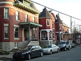
The architecture of the neighborhood is a mixture of large, wood framed and brick Victorian
houses and working class shotgun house
s, which often sit right next to each other. In recent years the area has attracted many professionals because of its proximity to downtown and the Baxter Avenue/Bardstown Road and Barret Avenue commercial corridors which include arts galleries, eclectic shopping, and night life.
National Products, a small factory at the corner of Breckinridge Street and Baxter Avenue, produces more disco ball
s than any other factory in the world. The stretch of Baxter Avenue between Highland Avenue and Broadway is known as one of Louisville's most popular destinations with its mix of bars, restaurants, galleries and shops. The Barret Avenue commercial corridor is an emerging art zone due to the large number of galleries.
The neighborhood is home to the Original Highlands Art and Music Festival. Held on Baxter Avenue each September, the festival features local and national music acts along with art and vendor booths.
The Original Highlands' boundaries are East Broadway on the north, Bardstown Road/Baxter Avenue on the east, Rufer Avenue on the south and Barret Avenue on the west. The Original Highlands Neighborhood Association also works closely with residents on Ellwood Avenue, located just to the south of Winter Avenue.
Louisville, Kentucky
Louisville is the largest city in the U.S. state of Kentucky, and the county seat of Jefferson County. Since 2003, the city's borders have been coterminous with those of the county because of a city-county merger. The city's population at the 2010 census was 741,096...
, USA. The neighborhood was built on land surveyed in 1774 and granted to Colonial William Preston, surveyor of Fincastle County, Virginia
Fincastle County, Virginia
Fincastle County, Virginia, was created in 1772 from Botetourt County, the boundaries of which extended all the way to the Mississippi River. Fincastle County was abolished in 1776, and divided into three new counties—Montgomery County, Washington County, and Kentucky County .Although no county...
. He died in 1781, and eventually his son, Major William Preston, and wife moved onto the land in 1814 and established a plantation called the "Briar Patch". The 1819 construction of the Louisville and Bardstown Turnpike (now Bardstown Road) would eventually lead to many people moving to the area. Before the American Civil War
American Civil War
The American Civil War was a civil war fought in the United States of America. In response to the election of Abraham Lincoln as President of the United States, 11 southern slave states declared their secession from the United States and formed the Confederate States of America ; the other 25...
the area was agricultural and attracted many German immigrants, and was known as New Hamburg.
Formal subdivision began after the land was inherited by Preston's daughter, Susan Preston Christy (after whom Christy Avenue is named). In 1869, Sydney J. Rogers subdivided Hepburn Avenue between Barrett and Baxter. Interest in the neighborhood picked up with the extension of a horse-drawn
Horsecar
A horsecar or horse-drawn tram is an animal-powered streetcar or tram.These early forms of public transport developed out of industrial haulage routes that had long been in existence, and from the omnibus routes that first ran on public streets in the 1820s, using the newly improved iron or steel...
streetcar line to Highland Avenue in 1871. The next subdivision was Hughes Addition, starting in 1875. Much of the rest of the land was subdivided by William Preston Johnson by 1891. The last was the Barr Subdivision in 1896.
Cherokee Park
Cherokee Park is a municipal park located in Louisville, Kentucky, United States. It was designed, like 18 of Louisville's 123 public parks, by Frederick Law Olmsted, the father of landscape architecture...
in 1891. Almost all of the land was developed by 1895. The vast majority of houses in the Original Highlands were constructed between 1860 and 1895, especially in the last 11 years of that period, during which 600 were built. The dwellings from before 1884 were mostly located along Breckinridge (formerly Howard), Christy, Baxter and Barret.
The area was simply called the Highlands because it sits on a ridge between the middle and south forks of Beargrass Creek
Beargrass Creek
Beargrass Creek is the name given to several forks of a creek in Jefferson County, Kentucky. The Beargrass Creek watershed is the largest in the county, draining over ....
, above the Ohio River
Ohio River
The Ohio River is the largest tributary, by volume, of the Mississippi River. At the confluence, the Ohio is even bigger than the Mississippi and, thus, is hydrologically the main stream of the whole river system, including the Allegheny River further upstream...
flood plain. Today eight other neighborhoods in the area on the same ridge are also collectively called The Highlands
The Highlands (Louisville)
The Highlands is an area of Louisville, Kentucky which contains a high density of nightclubs, eclectic businesses, and many upscale and fast food restaurants. It is centered along a three-mile stretch of Bardstown Road and Baxter Avenue and is so named because it sits atop a ridge between the...
. The Original Highlands name has developed to distinguish it from these neighborhoods; the Highlands sometimes specifically refers to this neighborhood.
The architecture of the neighborhood is a mixture of large, wood framed and brick Victorian
Victorian architecture
The term Victorian architecture refers collectively to several architectural styles employed predominantly during the middle and late 19th century. The period that it indicates may slightly overlap the actual reign, 20 June 1837 – 22 January 1901, of Queen Victoria. This represents the British and...
houses and working class shotgun house
Shotgun house
The shotgun house is a narrow rectangular domestic residence, usually no more than 12 feet wide, with doors at each end. It was the most popular style of house in the Southern United States from the end of the American Civil War , through the 1920s. Alternate names include shotgun shack,...
s, which often sit right next to each other. In recent years the area has attracted many professionals because of its proximity to downtown and the Baxter Avenue/Bardstown Road and Barret Avenue commercial corridors which include arts galleries, eclectic shopping, and night life.
National Products, a small factory at the corner of Breckinridge Street and Baxter Avenue, produces more disco ball
Disco ball
A disco ball is a roughly spherical object that reflects light directed at it in many directions, producing a complex display...
s than any other factory in the world. The stretch of Baxter Avenue between Highland Avenue and Broadway is known as one of Louisville's most popular destinations with its mix of bars, restaurants, galleries and shops. The Barret Avenue commercial corridor is an emerging art zone due to the large number of galleries.
The neighborhood is home to the Original Highlands Art and Music Festival. Held on Baxter Avenue each September, the festival features local and national music acts along with art and vendor booths.
The Original Highlands' boundaries are East Broadway on the north, Bardstown Road/Baxter Avenue on the east, Rufer Avenue on the south and Barret Avenue on the west. The Original Highlands Neighborhood Association also works closely with residents on Ellwood Avenue, located just to the south of Winter Avenue.
Demographics
As of 2000, the population of the Original Highlands was 1,580 , of which 89.4% are white, 6.8% are listed as other, 2.7% are black, and 1.1% are Hispanic. College graduates are of the 34.3% population, people w/o a high school degree are 12.6%. Males outnumber females 53.7% to 46.3%.See also
- History of Louisville, KentuckyHistory of Louisville, KentuckyThe history of Louisville, Kentucky spans hundreds of years, with thousands of years of human habitation. The area's geography and location on the Ohio River attracted people from the earliest times. The city is located at the Falls of the Ohio River...
- List of Registered Historic Places in Jefferson County, Kentucky
- List of attractions and events in Louisville, Kentucky
External links
- The Original Highlands Neighborhood Association (OHNA) Website
- The Original Highlands Art and Music Festival Website
- The Original Highlands Silent Auction and Wine Tasting Website
- Street map of The Original Highlands
- The Original Highlands Neighborhood Plan
- http://digital.library.louisville.edu/cdm4/results.php?CISORESTMP=results.php&CISOVIEWTMP=item_viewer.php&CISOMODE=grid&CISOGRID=thumbnail,A,1;title,A,1;subjec,A,0;descri,200,0;none,A,0;20;title,none,none,none,none&CISOBIB=title,A,1,N;subjec,A,0,N;descri,200,0,N;none,A,0,N;none,A,0,N;20;title,none,none,none,none&CISOTHUMB=20%20(4x5);title,none,none,none,none&CISOTITLE=20;title,none,none,none,none&CISOHIERA=20;subjec,title,none,none,none&CISOSUPPRESS=0&CISOTYPE=link&CISOOP1=exact&CISOFIELD1=coveraa&CISOBOX1=Original+Highlands+%28Louisville%2C+Ky.%29&CISOOP2=exact&CISOFIELD2=subjec&CISOBOX2=&CISOOP3=exact&CISOFIELD3=descri&CISOBOX3=&CISOOP4=exact&CISOFIELD4=CISOSEARCHALL&CISOBOX4=&c=exact&CISOROOT=all Images of Original Highlands (Louisville, Ky.) in the University of Louisville Libraries Digital Collections]