
.gif)
Old Black (Great Smoky Mountains)
Encyclopedia
Old Black is a mountain in the Great Smoky Mountains
, located in the Southeastern United States. While often overshadowed by Mount Guyot
, its higher neighbor to the south, Old Black is the 4th-highest mountain in
Tennessee
http://www.peakbagger.com/list.aspx?lid=21450 and the 7th-highest in the Great Smoky Mountains National Park
.http://www.nps.gov/grsm/naturescience/mountains.htm The Appalachian Trail
crosses its western slope, connecting the Cosby-area trail system with the heart of the Eastern Smokies.
Like much of the Smokies crest, Old Black lies along the border between Tennessee and North Carolina
, with Cocke County and Sevier County
to the west and Haywood County
to the east. The mountain rises
4400 feet (1,341.1 m) above its northwestern base near Rocky Grove http://www.topozone.com/map.asp?lat=35.76667&lon=-83.28806 and 3300 feet (1,005.8 m) above its southeastern base near Walnut Bottom.http://www.topozone.com/map.asp?lat=35.72139&lon=-83.16306 Old Black is part of the Guyot massif, which extends deep into the interior of the Smokies. A ridge known as Pinnacle Lead intersects this massif— which comprises the eastern section of the crest of the Smokies— on the western slope of Old Black, giving Old Black a triangular shape similar to that of Tricorner Knob
to the south.
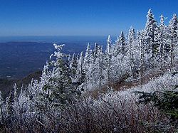
Old Black gets its name from the dense Southern Appalachian spruce-fir forest
that coats its higher elevations. From afar, this forest takes on a dark green character, especially in cooler months when contrasted with the brown hardwood
forest in lower elevations. This forest also adds to Old Black's blunt appearance— that of a low pyramid with a wide base.
metamorphic rock common throughout the Smokies.
The rock is part of the Ocoee Supergroup, which was formed from ocean sediments nearly a billion years ago. The mountain was created over 200 million years ago during the Appalachian orogeny, when the North American and African plates collided, thrusting the rock upward.
 Arnold Guyot first measured the elevation of Old Black on his survey of the crest of the Smokies in the late 1850s. Guyot measured the mountain's elevation at 6373 feet (1,942.5 m), missing the modern measurement by just three feet. While Guyot initially named the mountain "Mount Henry" after the director of the Smithsonian Institution
, "Old Black" was the name that stuck.
Laura Thornborough, a writer who made several excursions to the area in the 1930s, recalled the thick spruce forest that dominates in the Eastern Smokies:
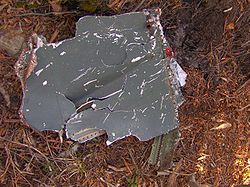
In 1984, an F-4 Phantom fighter plane crashed into the ridge between Inadu Knob and Old Black. Some of the wreckage from this crash remains scattered about the area, with a number of fragments located in an area along the Appalachian Trail about a quarter-mile west of the trail's junction with the Snake Den Ridge Trail
. A short spur trail winds through the wreckage.
In 1935, the CCC
constructed a segment of the Appalachian Trail
across the western slope of Old Black.
 Like most of the key peaks of the Eastern Smokies, Old Black can only be reached via a lengthy hike. The mountain is just over six miles (10 km) from the nearest parking lot at the Cosby
Campground. The quickest route involves following the Snake Den Ridge Trail out of Cosby (the trailhead is behind Campsite B51) for 5.3 miles (8.5 km) to the Appalachian Trail
junction at Inadu Knob. From this junction, Old Black is nearly a mile to the northwest. The trail comes to within less than a 10th of a mile from the summit, but the thickness of the forest atop the mountain will considerably slow any bushwhack attempt, and make off-trail navigation difficult.
As the Appalachian Trail crosses Old Black's western slope, various clearings allow for spectacular views of Cocke County and Sevier County
, Tennessee to the north and northwest. Along the mountain's northeast slope, near a clearing used for a high-altitude helicopter landing pad, much of the Eastern Smokies and the Balsam Mountains can be seen, including Mount Sterling and Luftee Knob. Some of the finest views of Mount Guyot
can be seen from this point.
Great Smoky Mountains
The Great Smoky Mountains are a mountain range rising along the Tennessee–North Carolina border in the southeastern United States. They are a subrange of the Appalachian Mountains, and form part of the Blue Ridge Physiographic Province. The range is sometimes called the Smoky Mountains or the...
, located in the Southeastern United States. While often overshadowed by Mount Guyot
Mount Guyot (Great Smoky Mountains)
Mount Guyot is a mountain in the eastern Great Smoky Mountains, located inthe southeastern United States. At above sea level, Guyot is the fourth-highestsummit in the eastern U.S., and the second-highest in the Great Smoky Mountains National Park...
, its higher neighbor to the south, Old Black is the 4th-highest mountain in
Tennessee
Tennessee
Tennessee is a U.S. state located in the Southeastern United States. It has a population of 6,346,105, making it the nation's 17th-largest state by population, and covers , making it the 36th-largest by total land area...
http://www.peakbagger.com/list.aspx?lid=21450 and the 7th-highest in the Great Smoky Mountains National Park
Great Smoky Mountains National Park
Great Smoky Mountains National Park is a United States National Park and UNESCO World Heritage Site that straddles the ridgeline of the Great Smoky Mountains, part of the Blue Ridge Mountains, which are a division of the larger Appalachian Mountain chain. The border between Tennessee and North...
.http://www.nps.gov/grsm/naturescience/mountains.htm The Appalachian Trail
Appalachian Trail
The Appalachian National Scenic Trail, generally known as the Appalachian Trail or simply the AT, is a marked hiking trail in the eastern United States extending between Springer Mountain in Georgia and Mount Katahdin in Maine. It is approximately long...
crosses its western slope, connecting the Cosby-area trail system with the heart of the Eastern Smokies.
Like much of the Smokies crest, Old Black lies along the border between Tennessee and North Carolina
North Carolina
North Carolina is a state located in the southeastern United States. The state borders South Carolina and Georgia to the south, Tennessee to the west and Virginia to the north. North Carolina contains 100 counties. Its capital is Raleigh, and its largest city is Charlotte...
, with Cocke County and Sevier County
Sevier County, Tennessee
Sevier County is a county of the state of Tennessee, United States. Its population was 71,170 at the 2000 United States Census. It is included in the Sevierville, Tennessee, Micropolitan Statistical Area, which is included in the Knoxville-Sevierville-La Follette, TN Combined Statistical Area. The...
to the west and Haywood County
Haywood County, North Carolina
-National protected areas:* Blue Ridge Parkway * Great Smoky Mountains National Park * Pisgah National Forest -Major Highways & Roads:* Interstate 40* U.S. Highway 19* U.S. Highway 23* U.S. Highway 74* U.S...
to the east. The mountain rises
4400 feet (1,341.1 m) above its northwestern base near Rocky Grove http://www.topozone.com/map.asp?lat=35.76667&lon=-83.28806 and 3300 feet (1,005.8 m) above its southeastern base near Walnut Bottom.http://www.topozone.com/map.asp?lat=35.72139&lon=-83.16306 Old Black is part of the Guyot massif, which extends deep into the interior of the Smokies. A ridge known as Pinnacle Lead intersects this massif— which comprises the eastern section of the crest of the Smokies— on the western slope of Old Black, giving Old Black a triangular shape similar to that of Tricorner Knob
Tricorner Knob
Tricorner Knob is a mountain in the Great Smoky Mountains, located in the Southeastern United States. It has an elevation of 6,120 feet , with 160 feet of clean prominence. The Appalachian Trail and Balsam Mountain Trail intersect near the mountain's summit, making Tricorner Knob the great...
to the south.
Old Black gets its name from the dense Southern Appalachian spruce-fir forest
Southern Appalachian spruce-fir forest
The Southern Appalachian spruce-fir forest is a type of montane coniferous forest that grows in the highest elevations in the southern Appalachian Mountains of the eastern United States...
that coats its higher elevations. From afar, this forest takes on a dark green character, especially in cooler months when contrasted with the brown hardwood
Hardwood
Hardwood is wood from angiosperm trees . It may also be used for those trees themselves: these are usually broad-leaved; in temperate and boreal latitudes they are mostly deciduous, but in tropics and subtropics mostly evergreen.Hardwood contrasts with softwood...
forest in lower elevations. This forest also adds to Old Black's blunt appearance— that of a low pyramid with a wide base.
Geology
Old Black comprises Thunderhead sandstone, a type of PrecambrianPrecambrian
The Precambrian is the name which describes the large span of time in Earth's history before the current Phanerozoic Eon, and is a Supereon divided into several eons of the geologic time scale...
metamorphic rock common throughout the Smokies.
The rock is part of the Ocoee Supergroup, which was formed from ocean sediments nearly a billion years ago. The mountain was created over 200 million years ago during the Appalachian orogeny, when the North American and African plates collided, thrusting the rock upward.
History
Smithsonian Institution
The Smithsonian Institution is an educational and research institute and associated museum complex, administered and funded by the government of the United States and by funds from its endowment, contributions, and profits from its retail operations, concessions, licensing activities, and magazines...
, "Old Black" was the name that stuck.
Laura Thornborough, a writer who made several excursions to the area in the 1930s, recalled the thick spruce forest that dominates in the Eastern Smokies:
As the A.T.Appalachian TrailThe Appalachian National Scenic Trail, generally known as the Appalachian Trail or simply the AT, is a marked hiking trail in the eastern United States extending between Springer Mountain in Georgia and Mount Katahdin in Maine. It is approximately long...
swings around the Tennessee side of Guyot, it passes through what is believed to be the densest stand of spruce and balsam in the Great Smokies.
In 1984, an F-4 Phantom fighter plane crashed into the ridge between Inadu Knob and Old Black. Some of the wreckage from this crash remains scattered about the area, with a number of fragments located in an area along the Appalachian Trail about a quarter-mile west of the trail's junction with the Snake Den Ridge Trail
Snake Den Ridge Trail
The Snake Den Ridge Trail is an American hiking trail in the Great Smoky Mountains National Park of Cocke County, Tennessee. Winding its way up the backbone-like crest of Snake Den Ridge, the trail connects the Cosby Campground to the Appalachian Trail and provides the quickest access to the high...
. A short spur trail winds through the wreckage.
In 1935, the CCC
Civilian Conservation Corps
The Civilian Conservation Corps was a public work relief program that operated from 1933 to 1942 in the United States for unemployed, unmarried men from relief families, ages 18–25. A part of the New Deal of President Franklin D...
constructed a segment of the Appalachian Trail
Appalachian Trail
The Appalachian National Scenic Trail, generally known as the Appalachian Trail or simply the AT, is a marked hiking trail in the eastern United States extending between Springer Mountain in Georgia and Mount Katahdin in Maine. It is approximately long...
across the western slope of Old Black.
Access
Cosby, Tennessee
Cosby is an unincorporated community in Cocke County, Tennessee, United States. Although it is not a census-designated place, the ZIP Code Tabulation Area for the ZIP Code that serves Cosby had a population of 5,201 as of the 2000 U.S. Census...
Campground. The quickest route involves following the Snake Den Ridge Trail out of Cosby (the trailhead is behind Campsite B51) for 5.3 miles (8.5 km) to the Appalachian Trail
Appalachian Trail
The Appalachian National Scenic Trail, generally known as the Appalachian Trail or simply the AT, is a marked hiking trail in the eastern United States extending between Springer Mountain in Georgia and Mount Katahdin in Maine. It is approximately long...
junction at Inadu Knob. From this junction, Old Black is nearly a mile to the northwest. The trail comes to within less than a 10th of a mile from the summit, but the thickness of the forest atop the mountain will considerably slow any bushwhack attempt, and make off-trail navigation difficult.
As the Appalachian Trail crosses Old Black's western slope, various clearings allow for spectacular views of Cocke County and Sevier County
Sevier County, Tennessee
Sevier County is a county of the state of Tennessee, United States. Its population was 71,170 at the 2000 United States Census. It is included in the Sevierville, Tennessee, Micropolitan Statistical Area, which is included in the Knoxville-Sevierville-La Follette, TN Combined Statistical Area. The...
, Tennessee to the north and northwest. Along the mountain's northeast slope, near a clearing used for a high-altitude helicopter landing pad, much of the Eastern Smokies and the Balsam Mountains can be seen, including Mount Sterling and Luftee Knob. Some of the finest views of Mount Guyot
Mount Guyot (Great Smoky Mountains)
Mount Guyot is a mountain in the eastern Great Smoky Mountains, located inthe southeastern United States. At above sea level, Guyot is the fourth-highestsummit in the eastern U.S., and the second-highest in the Great Smoky Mountains National Park...
can be seen from this point.
External links
- Great Smoky Mountains National Park Trail Map - Large file in .pdf format.
- Old Black -Peakbagger.com
- South Beyond 6000 in the Eastern Smokies - Information provided by the Carolina Hiking Club for climbing Old Black and other nearby high peaks.