

Tricorner Knob
Encyclopedia
Great Smoky Mountains
The Great Smoky Mountains are a mountain range rising along the Tennessee–North Carolina border in the southeastern United States. They are a subrange of the Appalachian Mountains, and form part of the Blue Ridge Physiographic Province. The range is sometimes called the Smoky Mountains or the...
, located in the Southeastern United States. It has an elevation of 6,120 feet (1,865 m), with 160 feet (48 m) of clean prominence.http://www.peakbagger.com/peak.aspx?pid=7774 The Appalachian Trail
Appalachian Trail
The Appalachian National Scenic Trail, generally known as the Appalachian Trail or simply the AT, is a marked hiking trail in the eastern United States extending between Springer Mountain in Georgia and Mount Katahdin in Maine. It is approximately long...
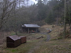
and Balsam Mountain Trail intersect near the mountain's summit, making Tricorner Knob the great crossroads of the Eastern Smokies. The Tricorner Knob Shelter, which occupies a flat area on the mountain's southern slope, provides a key rest stop for Appalachian Trail thru-hikers.
Like much of the Smokies crest, Tricorner Knob is on the border between Tennessee
Tennessee
Tennessee is a U.S. state located in the Southeastern United States. It has a population of 6,346,105, making it the nation's 17th-largest state by population, and covers , making it the 36th-largest by total land area...
and North Carolina
North Carolina
North Carolina is a state located in the southeastern United States. The state borders South Carolina and Georgia to the south, Tennessee to the west and Virginia to the north. North Carolina contains 100 counties. Its capital is Raleigh, and its largest city is Charlotte...
. As its name implies, the mountain is at the point where the Balsam Mountains intersect the crest of the Great Smokies, creating a triangular-shaped ridge.http://www.topozone.com/map.asp?lat=35.69563&lon=-83.25408&size=m&u=4&datum=nad27&layer=DRG Three counties intersect at the summit of Tricorner, with Sevier County
Sevier County, Tennessee
Sevier County is a county of the state of Tennessee, United States. Its population was 71,170 at the 2000 United States Census. It is included in the Sevierville, Tennessee, Micropolitan Statistical Area, which is included in the Knoxville-Sevierville-La Follette, TN Combined Statistical Area. The...
, Tennessee to the west, Haywood County
Haywood County, North Carolina
-National protected areas:* Blue Ridge Parkway * Great Smoky Mountains National Park * Pisgah National Forest -Major Highways & Roads:* Interstate 40* U.S. Highway 19* U.S. Highway 23* U.S. Highway 74* U.S...
, North Carolina to the northeast, and Swain County, North Carolina to the southeast. The mountain rises appx. 3300 feet (1,005.8 m) above its western base at the mouth of Buck Fork, along the Little Pigeon River
Little Pigeon River (Tennessee)
The Little Pigeon River is a river located entirely within Sevier County, Tennessee.It rises from a series of streams which flow together on the dividing ridge between the states of Tennessee and North Carolina inside the boundary of the Great Smoky Mountains National Park. The river is subdivided...
.http://www.topozone.com/map.asp?lat=35.69558&lon=-83.32379&datum=nad27&u=4&layer=DRG&size=m&s=50 Tricorner is the 9th-highest mountain in Tennessee and the 27th-highest mountain in North Carolina.http://www.americasroof.com/6000.shtml
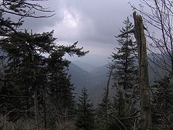
Tricorner Knob's remote situation in the dense Southern Appalachian spruce-fir forest
Southern Appalachian spruce-fir forest
The Southern Appalachian spruce-fir forest is a type of montane coniferous forest that grows in the highest elevations in the southern Appalachian Mountains of the eastern United States...
of the Eastern Smokies has left it largely untouched by human history. Arnold Guyot measured its elevation on his survey of the crest of the Smokies in 1859, placing Tricorner's elevation at 6188 feet (1,886.1 m). Other than surveyors and the occasional naturalist, the mountain was devoid of human visitors until a segment of the Appalachian Trail was constructed across its western slope in 1935. An isolated spring on the mountain's southern slope was the key reason behind its selection for the back country campsite where the Tricorner Knob Shelter sits today. Laura Thornborough, a writer who visited the mountain in the late 1930s, called Tricorner Knob one of the last "true wilderness areas, where one can commune with nature and leave the cares of the world behind."
Access
Snake Den Ridge Trail
The Snake Den Ridge Trail is an American hiking trail in the Great Smoky Mountains National Park of Cocke County, Tennessee. Winding its way up the backbone-like crest of Snake Den Ridge, the trail connects the Cosby Campground to the Appalachian Trail and provides the quickest access to the high...
winds 5.3 miles (8.5 km) up the ridge to its junction with the Appalachian Trail. From this junction, Tricorner is 3.7 miles (6 km) away, with the trail first crossing the slopes of Old Black
Old Black (Great Smoky Mountains)
Old Black is a mountain in the Great Smoky Mountains, located in the Southeastern United States. While often overshadowed by Mount Guyot, its higher neighbor to the south, Old Black is the 4th-highest mountain in...
and Mount Guyot
Mount Guyot (Great Smoky Mountains)
Mount Guyot is a mountain in the eastern Great Smoky Mountains, located inthe southeastern United States. At above sea level, Guyot is the fourth-highestsummit in the eastern U.S., and the second-highest in the Great Smoky Mountains National Park...
. The Balsam Mountain Trail is a 6 miles (9.7 km) trail connecting the Appalachian Trail in the west with the Benton MacKaye Trail
Benton MacKaye Trail
The Benton MacKaye Trail or BMT is a footpath nearly in length in the Appalachian Mountains in the southeastern United States and is blazed by a white diamond, 5" across by 7" tall...
to the east. The latter can be accessed via a sharp bend in Straight Fork Road, a rugged gravel road rising out of Cherokee, North Carolina. From this bend, Tricorner Knob is just over 10 miles (16.1 km) away. A 15 miles (24.1 km) section of the Appalachian Trail connects Tricorner Knob with Newfound Gap
Newfound Gap
Newfound Gap is a mountain pass located near the center of the Great Smoky Mountains National Park of the southern Appalachian Mountains in the United States of America. Situated along the border of Tennessee and North Carolina, the state line crosses the gap, as does U.S...
in the Central Smokies.
The Tricorner Knob Shelter can accommodate 12 people.http://home.nps.gov/applications/parks/grsm/ppdocuments/2002.pdf Overnight campers are required to get a permit from the park service. The shelter is approximately halfway between the Peck's Corner Shelter to the west and the Cosby Knob Shelter to the northeast.
External links
- Great Smoky Mountains National Park Trail Map - Large file in .pdf format.
- Tricorner Knob Shelter
- Tricorner Knob - Peakbagger.com
- South Beyond 6000 in the Smokies - Details on climbing Tricorner Knob and other nearby mountains. Provided by the Carolina Hiking Club.